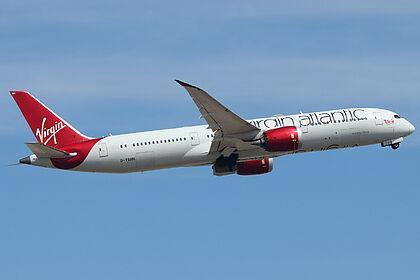
#406B48

Above MaidstoneAboveMaidstone
2025-05-21

Flight:
ICAO code:
Registration: G-VAHH
Type: BOEING 787-9 Dreamliner
Operator: Virgin Atlantic
Direction: 90° (East)
Speed: 380.0 kmh
Altitude: 12875 ft
Category: Heavy

Route:
🛫: London -
🛬: Bangalore -
🤖: Autopilot engaged

Previously seen: 104 times

Track:
globe.adsb.fi/?icao=406b48

Photo by: Jan Seler
Link: hooks.geekyco.de/ps/406b48

📡 Flight Radar Mechelen 🇧🇪RadarMechelen
2025-05-14

Flight:
Registration: G-VAHH
ICAO code:
Callsign:
Operator: Virgin Atlantic
Type: BOEING 787-9
Country: 🇬🇧
From: to
Speed: 954 kmh
Altitude: 11582 m
Distance: 9.5 km
Angle ∆: 50.7°
Direction ->: WNW
Track:
tinyurl.com/267l56wz
History:
radarbox.com/data/mode-s/406B48
flightradar24.com/data/aircraf
Photos:
jetphotos.com/photo/keyword/G-
Seen: 67x

📡 Flight Radar Mechelen 🇧🇪RadarMechelen
2025-04-23

Flight:
Registration: G-VAHH
ICAO code:
Callsign:
Operator: Virgin Atlantic
Type: BOEING 787-9
Country: 🇬🇧
From: to
Speed: 853 kmh
Altitude: 11582 m
Distance: 8.7 km
Angle ∆: 53.1°
Direction ->: WNW
Track:
tinyurl.com/24k2ddbw
History:
radarbox.com/data/mode-s/406B48
flightradar24.com/data/aircraf
Photos:
jetphotos.com/photo/keyword/G-
Seen: 66x

📡 Flight Radar Mechelen 🇧🇪RadarMechelen
2025-04-20

Flight:
Registration: G-VAHH
ICAO code:
Callsign:
Operator: Virgin Atlantic
Type: BOEING 787-9
Country: 🇬🇧
From: to
Speed: 925 kmh
Altitude: 12192 m
Distance: 4.3 km
Angle ∆: 70.4°
Direction ->: WNW
Track:
tinyurl.com/29c2dybf
History:
radarbox.com/data/mode-s/406B48
flightradar24.com/data/aircraf
Photos:
jetphotos.com/photo/keyword/G-
Seen: 65x

📡 Flight Radar Mechelen 🇧🇪RadarMechelen
2025-04-14

Flight:
Registration: G-VAHH
ICAO code:
Callsign:
Operator: Virgin Atlantic
Type: BOEING 787-9
Country: 🇬🇧
From: to
Speed: 879 kmh
Altitude: 12184 m
Distance: 8.2 km
Angle ∆: 56.0°
Direction ->: WNW
Track:
tinyurl.com/233whrb2
History:
radarbox.com/data/mode-s/406B48
flightradar24.com/data/aircraf
Photos:
jetphotos.com/photo/keyword/G-
Seen: 64x

📡 Flight Radar Mechelen 🇧🇪RadarMechelen
2025-02-21

Flight:
Registration: G-VAHH
ICAO code:
Callsign:
Operator: Virgin Atlantic
Type: BOEING 787-9
Country: 🇬🇧
From: to
Speed: 796 kmh
Altitude: 11575 m
Distance: 7.1 km
Angle ∆: 58.5°
Direction ->: WNW
Track:
tinyurl.com/2dnbkq3s
History:
radarbox.com/data/mode-s/406B48
flightradar24.com/data/aircraf
Photos:
jetphotos.com/photo/keyword/G-
Seen: 63x

📡 Flight Radar Mechelen 🇧🇪RadarMechelen
2025-01-31

Flight:
Registration: G-VAHH
ICAO code:
Callsign:
Operator: Virgin Atlantic
Type: BOEING 787-9
Country: 🇬🇧
From: to
Speed: 852 kmh
Altitude: 11575 m
Distance: 8.9 km
Angle ∆: 52.6°
Direction ->: WNW
Track:
tinyurl.com/28ztbugc
History:
radarbox.com/data/mode-s/406B48
flightradar24.com/data/aircraf
Photos:
jetphotos.com/photo/keyword/G-
Seen: 62x

📡 Flight Radar Mechelen 🇧🇪RadarMechelen
2025-01-19

Flight:
Registration: G-VAHH
ICAO code:
Callsign:
Operator: Virgin Atlantic
Type: BOEING 787-9
Country: 🇬🇧
From: to
Speed: 959 kmh
Altitude: 12184 m
Distance: 9.7 km
Angle ∆: 51.6°
Direction ->: WNW
Track:
tinyurl.com/266s7n3j
History:
radarbox.com/data/mode-s/406B48
flightradar24.com/data/aircraf
Photos:
jetphotos.com/photo/keyword/G-
Seen: 61x

📡 Flight Radar Mechelen 🇧🇪RadarMechelen
2025-01-18

Flight:
Registration: G-VAHH
ICAO code:
Callsign:
Operator: Virgin Atlantic
Type: BOEING 787-9
Country: 🇬🇧
From: to
Speed: 906 kmh
Altitude: 11575 m
Distance: 8.0 km
Angle ∆: 55.2°
Direction ->: WNW
Track:
tinyurl.com/25ckgv8x
History:
radarbox.com/data/mode-s/406B48
flightradar24.com/data/aircraf
Photos:
jetphotos.com/photo/keyword/G-
Seen: 60x

📡 Flight Radar Mechelen 🇧🇪RadarMechelen
2024-12-11

Flight:
Registration: G-VAHH
ICAO code:
Callsign:
Operator: Virgin Atlantic
Type: BOEING 787-9
Country: 🇬🇧
From: to
Speed: 910 kmh
Altitude: 11582 m
Distance: 5.5 km
Angle ∆: 64.7°
Direction ->: WNW
Track:
tinyurl.com/24hjjlsx
History:
radarbox.com/data/mode-s/406B48
flightradar24.com/data/aircraf
Photos:
jetphotos.com/photo/keyword/G-
Seen: 59x

📡 Flight Radar Mechelen 🇧🇪RadarMechelen
2024-12-06

Flight:
Registration: G-VAHH
ICAO code:
Callsign:
Operator: Virgin Atlantic
Type: BOEING 787-9
Country: 🇬🇧
From: to
Speed: 696 kmh
Altitude: 12192 m
Distance: 8.2 km
Angle ∆: 56.1°
Direction ->: WNW
Track:
tinyurl.com/28jr8r4f
History:
radarbox.com/data/mode-s/406B48
flightradar24.com/data/aircraf
Photos:
jetphotos.com/photo/keyword/G-
Seen: 58x

📡 Flight Radar Mechelen 🇧🇪RadarMechelen
2024-11-29

Flight:
Registration: G-VAHH
ICAO code:
Callsign:
Operator: Virgin Atlantic
Type: BOEING 787-9
Country: 🇬🇧
From: to
Speed: 853 kmh
Altitude: 11278 m
Distance: 9.2 km
Angle ∆: 50.9°
Direction ->: WNW
Track:
tinyurl.com/2de7m2xz
History:
radarbox.com/data/mode-s/406B48
flightradar24.com/data/aircraf
Photos:
jetphotos.com/photo/keyword/G-
Seen: 57x

📡 Flight Radar Mechelen 🇧🇪RadarMechelen
2024-09-19
📡 Flight Radar Mechelen 🇧🇪RadarMechelen
2024-09-18
📡 Flight Radar Mechelen 🇧🇪RadarMechelen
2024-09-17
📡 Flight Radar Mechelen 🇧🇪RadarMechelen
2024-09-16
📡 Flight Radar Mechelen 🇧🇪RadarMechelen
2024-09-02
📡 Flight Radar Mechelen 🇧🇪RadarMechelen
2024-08-17
📡 Flight Radar Mechelen 🇧🇪RadarMechelen
2024-08-03
📡 Flight Radar Mechelen 🇧🇪RadarMechelen
2024-08-02

Client Info

Server: https://mastodon.social
Version: 2025.04
Repository: https://github.com/cyevgeniy/lmst