#AirNow

2024-11-09

Dangerous air quality hits New York as brush fires erupt in #Northeast

Firefighters battled brush fires in #NewJersey and Brooklyn.

ByIvan Pereira
November 9, 2024,

"#NewYorkCity officials issued an air quality alert Saturday morning amid several #brushfires burning in the U.S. northeast, including one in #Brooklyn's largest park the previous night.

The city's Office of Emergency Management said the Air Quality Index (#AQI) is forecast to reach 101-150 on Saturday. Under those conditions, the air is not safe for people with sensitive breathing issues and the elderly, according to the federal government's #AirNow resource."

Read more:
abcnews.go.com/US/dangerous-ai

#Wildfires #NortheastWildfires #ClimateDiary #ClimateCrisis #AirQuality #NewYork #NewJersey

2024-11-04

In other news, here are some #weather websites that I visit frequently -- some of them very useful when it comes to #wildfires and #AQI...

#ZoomEarth | Live Weather Map & Hurricane Tracker
zoom.earth/

National Weather Service [#NWS]
weather.gov/

World Weather Map - Interactive weather map.
map.worldweatheronline.com/

#Windy: Wind map & weather forecast
windy.com/

#AirNow Fire and Smoke Map
fire.airnow.gov/

World's Air Pollution: Real-time Air Quality Index [#WAQI]
waqi.info/

#ClimateChange #Weather #Wildfires #AirQuality #WorldWeather #Climate
#ExtremeWeather

2024-10-29

The #AirNow #Fire and #Smoke Map provides information that you can use to help protect your health from #wildfire smoke.

New in Version 4

"The U.S. Environmental Protection Agency [#EPA] and the U.S. #ForestService are pleased to bring you this updated AirNow Fire and Smoke Map, with even more information you can use to protect yourself from wildland fire smoke. In addition, this version features an updated display that allows you to get a quick glance at information, tailored user interfaces for both desktop and mobile, and faster loading.

How To Use This Map

"The AirNow Fire and Smoke Map provides information that you can use to help protect your health from wildfire smoke."

Map:
fire.airnow.gov/

More info:
airnow.gov/

#ClimateChange #ClimateCrisis #Drought #WildfireSeason #Wildfires #Smoke #AirQuality #AirQualityAlert #AirIsLife #AQI

2024-10-29

#NorthShore brush fires sent smoke to #Boston β€” and eluded #AirQuality readers

Story by Steph Solis
October 28, 2024

"The smoke from brush fires around #Salem wafted over Boston on Monday, puzzling residents who got no indication of it from air quality readings on their phones.

"Why it matters: As #ClimateChange makes wildfires more likely and severe in the U.S., #Massachusetts residents will have to learn to detect the signs and protect themselves.

"Catch up quick: Firefighters are battling brush fires across #Salem, #Peabody and #Lynn, sending smoke as far south as Foxborough.

"More than 130 acres of brush have burned since Saturday, NBC Boston reported.

"Between the lines: Smoke inhalation can harm people with all sorts of health conditions, from those with asthma and emphysema to heart attack survivors.

"It's especially risky for children, whose lungs are still developing, says Anthony Wexler, director of the Air Quality Research Center at UC Davis.

"Multiple studies show air pollution can hurt lung development.

"How it works: The smoke smell caught locals' attention in the morning, as opposed to Monday afternoon, because smoke stays close to the ground after the Sun sets, Wexler says.

Once the Sun rises, it warms up the ground and mixes low-lying air with cleaner air above, causing the smoke to dissipate as the day progresses.

"Yes, but: The smoke didn't show up on some air quality readings, like the ones on iPhones.

"That's because the state and federal governments only have a few air quality monitors in a given community. If a plume of smoke passed through your neighborhood but missed the monitor, the reading will end up lower.

"Commercial air quality readers like #PurpleAir monitors are inexpensive and more common, so they can give better readings, Wexler notes.

"#AirNow, the federal government's service, also has better readings on its smoke and fire map."

msn.com/en-us/weather/topstori

#AirIsLife #WildfireSeason
#ExtremeDrought #ClimateCrisis #NorthShoreOfMassachusetts
#EssexCountyMassachusetts
#SalemMA #MiddletonMA #LynnMA
2024-10-29

#Salem High School dismisses early as brush fires cause unhealthy air quality

Tuesday morning was the worst the air quality has been since the first significant fire broke out in Salem, based on data from the EPA

By Thea DiGiammerino and Alysha Palumbo
Published October 29, 2024

"''The fire itself is not the danger. It’s the air quality this morning,' said Chris O’Donnell, Salem Public Schools Director of Communications. 'As we arrived on campus this morning we could smell quite a bit of smoke. There’s always initial concern but we made it clear that the fire is not the danger.'

"According to the Environmental Protection Agency's #AirNow Fire and Smoke Map, air quality in Lynn had reached #HazardousLevels - over 300 PPM - early Tuesday morning, the worst alert level listed and considered an emergency. As of mid-morning it had dropped into the 'very unhealthy' level - between 201 to 300 PM - a category where the risk of health effects is increased for everyone. Levels may fluctuate depending on the fires and weather conditions. The public is advised to limit outdoor activities when possible.

"This is the second day of air quality concerns from the fire. On Monday the smell of smoke was strong all over the #Boston area due to a weather phenomenon called #inversion. That's when warm air traps cool air and smoke close to the ground, and that can be a concern for air quality because #wildfire smoke has been shown to carry #pollutants."

necn.com/news/local/air-qualit

#AirLisLife #WildfireSeason
#ExtremeDrought #ClimateChange
#ClimateCrisis #NorthShore
#NorthShoreOfMassachusetts
#EssexCountyMassachusetts
#SalemMassachusetts #AirQualityAlert

Edge πŸ‡¨πŸ‡¦πŸ‡²πŸ‡½πŸ‡ΊπŸ‡¦πŸ³οΈβ€πŸŒˆczarbucks@vmst.io
2024-07-05

Welcome for #Friday, July 5th here in #Asheville. The NWS keeps flirting with rain forecasts, but of course it never clears the mountains and actually arrives here. (Forecast high of 90F with thunderstorms.)

Big issue this morning is air quality, which at CzarBucks Corporate Headquarters was reported at 93. (Yet Buncombe County is still allowing open burning.)

If you're out today, please hydrate, and be "careful" of the air, however one can.

#Airnow.gov #AQI

A screencap from airnow.gov, the government's national map of air quality.  I didn't include most of the western states, but was looking for the source of all the smoke and it might actually be anywhere.

Much of the eastern half (and up from TX) is yellow, with locations of orange and red, indicating even worse air.  Please be careful if you're outside, and avoid exertion if you can.  Definitely NOT good for lungs.
Chuck Darwincdarwin@c.im
2024-06-09

According to #AirNow,
a coalition between the U.S. government and tribal agencies that monitors air quality,
Friday's air quality was expected to be the worst
in southern California and southern Nevada, eastern Texas, and in parts of Mississippi and Tennessee

c.im/@cdarwin/1125879006863731

fire.airnow.gov

Ozzie D, NP-hard :bikepump: :vegan:ozdreaming@infosec.exchange
2024-05-20

Here comes #smoke season. I know folks in the northwest & midwest don't need any PSAs about this, but for east coasters, a reminder that near-realtime air quality monitoring is available at airnow.gov (the fire and smoke map is at fire.airnow.gov/). Canada's version is at weather.gc.ca/airquality/pages.

The #EPA updated air quality standards and the Air Quality Index (#AQI) this year, lowering fine-particle (PM2.5) thresholds at a couple of breakpoints on their scale; more details here: epa.gov/system/files/documents

#airpollution #wildfire #airnow #n95 #masks

Chris WarwickChrisWarwick@mas.to
2024-05-15

@Aminorjourney @geerlingguy
Thanks... I looked into the integration and API and (for anyone who's wondering) the coverage is pretty much exclusively North America. There are apparently monitoring stations in other countries (at some US embassies) but nothing in Northern Europe. #HomeAssistant #Airnow

SemiRandomSevens :firefox:SemiRandomSevens@techhub.social
2023-07-18

For the first day in too many, the government home of the U.S. Air Quality Index says my air quality is 'Good'. A pleasing improvement from when it was 'Very Unhealthy'. Searchable site of air quality data. #airquality #breathing #airnow

airnow.gov/

Edge πŸ‡¨πŸ‡¦πŸ‡²πŸ‡½πŸ‡ΊπŸ‡¦πŸ³οΈβ€πŸŒˆczarbucks@vmst.io
2023-07-16

#AirNow is showing a huge swath of bad air again, diagonally from NW Canada, down to St Louis and beyond in the States.

Be safe, and plan your day, if you're able to.

gispub.epa.gov/airnow/?showgre

Keith Iveykcivey
2023-06-30

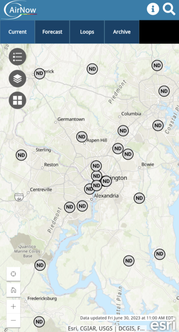
appears to be having problems. Not updated since noon.

AirNow map of DC area with all monitors shown as gray circles with ND (no data).
2023-06-28

Somehow... the code for one of these blocks - should be talking to the other block...

#AirNow
AirNow.gov

AirNow.gov Current Air Quality - 2 sections + color blob map.

Text section shows 
-- Primary pollutant : PM2.5 of 193 "Unhealthy"...

-- Secondary section below shows Ozone range Good. With subtext: "Enjoy your outdoor activities"

Hence my post comment: the 2 sections should talk before making conflicting recommendations.
Edge πŸ‡¨πŸ‡¦πŸ‡²πŸ‡½πŸ‡ΊπŸ‡¦πŸ³οΈβ€πŸŒˆczarbucks@vmst.io
2023-06-12

Yes, we again again breathe the air, according to both #PurpleAir and #AirNow. Hoping others find the same relief, and Canada sees an end to their spate of #fires
#Asheville #NC

A screencap of the Purple Air application, showing Asheville with an AQI of 16, Canton at 0, and other local cities at similar low, green (good) readings.  Purple Air must not notice Canton's paper mill...
2023-06-08

A government smoke map for northeast US. A very large area affected, with the worst numbers in the Philadelphia to Washington, DC, range.
fire.airnow.gov/
--
#AirNow #Philadelphia #WashingtonDC #smoke #map

Screenshot of the current map as described in the toot, with colored dots representing the smoke pollution in the air at many locations.
Keith Iveykcivey
2023-06-08

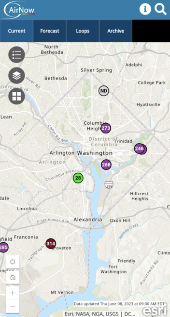
The maroon PM2.5 level for "DC" is actually in Franconia. The DC monitors on AirNow are purple. Not that that makes a real difference. There's also a green dot in Arlington because that monitor doesn't measure particulates, only ozone.

Map of DC area should 4 purple dots in DC, 1 green in Arlington, and 1 maroon in Franconia.
Ed W8EMV :city_ann_arbor:w8emv@a2mi.social
2023-06-07

Reading air quality stats. It appears to be that you should look at at least 3 web sites to get a complete picture of Ann Arbor.

1) EPA "Airnow" airnow.gov/?city=Ann%20Arbor&s
2) PurpleAir (a sensor you can buy) map.purpleair.com/1/mAQI/a10/p
3) City of Ann Arbor "Air Quality in Ann Arbor" analytics.a2gov.org/superset/d

The EPA sensors aren't everywhere; the PurpleAir sensors are mostly in affluent areas; and several of the City of Ann Arbor sensors are offline.

#AirQuality #AirNow

2023-05-10

Despite the smoke overhead, it looks like we aren’t seeing meaningful impacts to ground-level air quality at the moment, though. #epa #airnow #airpollution #purpleair

Map from U.S. EPA AirNow showing that the nowcast AQI is good at monitors in the Washington, DC region.Map from PurpleAir showing that PM2.5 concentrations in the Washington, DC region are generally low to moderate.

Client Info

Server: https://mastodon.social
Version: 2025.04
Repository: https://github.com/cyevgeniy/lmst