Satellites Reveal The Power Of Ocean Swell
--
https://www.esa.int/Applications/Observing_the_Earth/Space_for_our_climate/Satellites_reveal_the_power_of_ocean_swell <-- shared technical article
--
https://doi.org/10.1073/pnas.2513381122 <-- shared paper
--
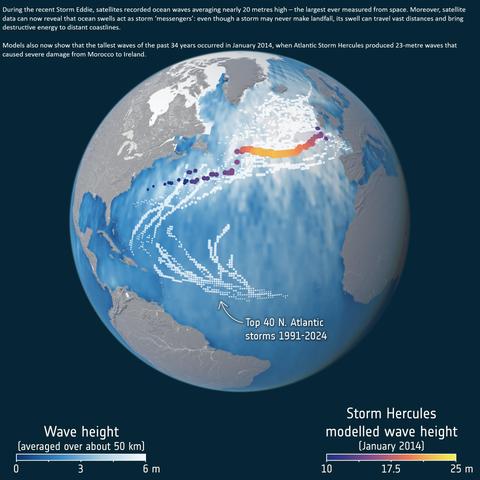
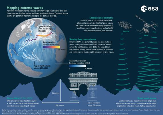
“During recent storms, satellites recorded ocean waves averaging nearly 20 metres high – the largest ever measured from space. Moreover, satellite data now reveal that ocean swells act as storm ‘messengers’ - even though a storm may never make landfall, its swell can travel vast distances and bring destructive energy to distant coastlines...
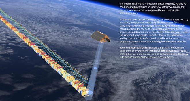
This record merges data from satellites such as #SARAL, #Jason3, #Copernicus #Sentinel 3A and 3B, Copernicus #Sentinel6 Michael Freilich, #CryoSat and #CFOSAT…”
#GIS #spatial #mapping #remotesensing #earthobservation #satellite #ocean #marine #oceanwaves #waves #swell #storm #extremeweather #risk #hazard #impacts #humanimpacts #coast #coastline #longswells #energy #erosion #weather #longwaves #ESA #ClimateChangeInitiative #CCI #SeaState #meteorology #coastalengineering #mitigation #ESA
@europeanspaceagency
#CryoSat
85 new subglacial lakes detected below Antarctica.
#ESA:
"
Grönland: subglaziale Überflutung bricht durch die Oberfläche der Eisschicht
"
"Anhand von Daten mehrerer Erdbeobachtungssatelliten .. haben Forschungsteams entdeckt, dass eine enorme Flut unter dem grönländischen Eisschild mit solcher Wucht nach oben gedrückt hat, dass sie den Eisschild aufgebrochen hat .."
30.7.2025
#Arktis #Cryosat #Eis #EO #Erdbeobachtung #Grönland #Klimakrise #Klimawandel #Raumfahrt #Satelliten #Sentinel1 #Sentinel2 #SpaceFlight
Un satellite européen repère 7 milliards de tonnes d’eau sous l’Antarctique : un vaste lac souterrain se vide sans prévenir.
https://media24.fr/2025/07/26/un-satellite-europeen-trouve-une-surprise-de-7-milliards-de-tonnes-sous-la-glace-de-lantarctique-dans-ces-lacs-souterrains-qui-se-vident-de-leur-eau-douce-sans-prevenir/
#Space #Astrophysics #SubglacialLakes #IceDynamics #CryoSat #SeaLevelRise
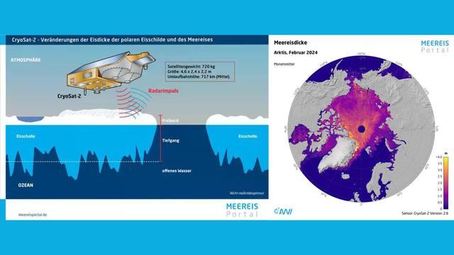
Im langjährigen Mittel sind etwa 7 % der globalen Ozeanfläche von #Meereis bedeckt. Satelliten wie #CryoSat-2 (ESA) erfassen aus über 700 km Höhe kontinuierlich hochaufgelöste Höhenprofile der Meereisoberfläche. Diese #Satellitendaten ermöglichen die Analyse von Veränderungen und Trends und sind grundlegend für das Verständnis klimarelevanter Prozesse in den #Polarregionen. Radaraltimeter messen präzise den Abstand zwischen Satellit und Eisoberfläche. #Klimaforschung
➡️ https://www.meereisportal.de/wissen/meereismessungen/messungen-aus-dem-weltall
ESA And NASA Deliver First Joint Picture Of Greenland Ice Sheet Melting
--
https://www.esa.int/Applications/Observing_the_Earth/FutureEO/CryoSat/ESA_and_NASA_deliver_first_joint_picture_of_Greenland_Ice_Sheet_melting <-- shared technical article
--
https://doi.org/10.1029/2024GL110822 <-- shared paper
--
[Visualising the latest results from ESA's CryoSat radar altimeter, consistent with measurements from NASA's ICESat-2 laser altimeter]
--
#GIS #spatial #mapping #remotesensing #earthobservation #cryosphere #Greenland #icesheet #melting #CryoSat #satellite #ICESat2 #spatiotemporal #spatialanalysis #Jakobshavn #glacier #ice #snow #radar #laser #iceloss #climatechange #altimeter #elevation #topography #height
@ESA @nasa
#FYI via #PeterCarter #CryoSat #ESA
Greenland Ice Sheet Shrinking at Incredible Rate
"Greenland ice sheet seen melting in real-time from Earth orbit
Agreement from two satellites CryoSat-2 and ICESat-2m. Between 2010 and 2023, Greenland lost 563 cubic miles (2,347 cubic kilometers) of ice, which is enough to fill Lake Victoria, Africa's largest lake."
#climate #ClimateScience #ClimateEmergency #ClimateCrisis #ClimateBreakdown #climatecatastrophe #ExtremeWeather
esa_cryosatの14周年を祝うツイート。14年間の地球の氷、水、海底のモニタリングを称賛し、継続と価値を祝っている。 #CryoSat
https://x.com/esa/status/1777239074266390756
Zum Jahreswechsel gibt es eine runde Sache. Und zwar die Folge 70. Diesmal mit der Geschichte des Forschungssatelliten #CryoSat, dessen Mission leider schon nach 308 Sekunden endete. https://digitaleanomalien.de/70-cryosat-und-die-dritte-stufe/ #podcast #space #weltraum
#ClimateCrisis: Antarctic ice shelf demise https://www.esa.int/Applications/Observing_the_Earth/Copernicus/Sentinel-1/Antarctic_ice_shelf_demise
"New research, based largely on information from the @CopernicusEU #Sentinel-1 and #ESA’s #CryoSat #satellite missions, has revealed alarming findings about the state of #Antarctica's ice shelves: 40% of these floating shelves have significantly reduced in volume over the past quarter-century."
Glacier Mass Loss Between 2010 And 2020 Dominated By Atmospheric Forcing [aka higher air temperatures]
--
https://doi.org/10.1029/2023GL102954 <-- shared paper
--
#GIS #spatial #mapping #remotesensing #satellite #ESA #CryoSat #radar #altimeter #elevation #change #swathprocessing #accuracy #precision #GlacierMassBalance #climatechange #glacial #glacier #melting #airtemperature #model #modeling #ice #global #spatialanalysis #3dmodeling #massloss
📢Are you a #CryoSat user and want data quality info at hand for your studies and applications? What kind of info would you find useful? We need your feedback to improve your QC reports! 🛰️❄️✅👇
---
RT @esa_cryosat
‼️ #CryoSat data users. We need your feedback! 🫵
👇👇👇👇👇👇
👉https://earth.esa.int/eogateway/news/cryosat-data-users-we-need-your-feedback 👈
https://twitter.com/esa_cryosat/status/1651846961908314117
#ESA:
"#CryoSat reveals #ice loss from #glaciers" ".. shrunk by a total of 2% in just 10 years."
".. scientists have used a particular technique of processing CryoSat data to reveal that glaciers lost a whopping 2720 Gigatonnes of ice between 2010 and 2020."
"Their research also demonstrates that higher air temperatures are responsible for 89% of this ice loss."
https://agupubs.onlinelibrary.wiley.com/doi/epdf/10.1029/2023GL102954
#Eis #Eisschmelze #Gletscher #Klimakrise #Klimawandel
26.4.2023
Best of luck!! 🤞🛰️❄️🛩️
---
RT @esa_cryosat
❄️ The Antarctic adventure begins 🛩️ Introducing the intrepid team of researchers descending on the south pole to improve satellite observations of Antarctic ice. In a week's time they'll be on the ice & in the air taking measurements to validate #CryoSat & #ICESat2 overhead /1
https://twitter.com/esa_cryosat/status/1597601429241630721
RT @esaoperations: 🛰 #CryoSat's close call – read the full story on how the satellite studying 🌎Earth's ice this week avoided a collision w…
RT @esaoperations: 🛰 #CryoSat's close call – read the full story on how the satellite studying 🌎Earth's ice this week avoided a collision w…
RT @esaoperations: It took a number of teams to maneouvre #CryoSat: the Space Debris office, flight dynamicists & satellite operation manag… source: https://twitter.com/esa/status/1017393732868505600
RT @esaoperations: It's confirmed, #CryoSat's🛰 2nd manoeuvre will take place tomorrow, Thursday, at 07:55 CEST! Haven't been glued to our t… source: https://twitter.com/esa/status/1017100470475616257
RT @esaoperations: Yesterday, for the 2nd time this year, teams @ESA's @ESA_EO control room altered the path of #CryoSat🛰️ preventing a col… source: https://twitter.com/esa/status/1016654118096719877
With some 250 million measurements over 6 years the #CryoSat mission has given us the most accurate #3D view ever of #Antarctica's vast ice sheet and floating ice shelves.
Details: http://www.esa.int/Our_Activities/Observing_the_Earth/CryoSat/New_view_of_Antarctica_in_3D https://twitter.com/esa/status/995579147220119552/photo/1 source: https://twitter.com/esa/status/995579147220119552
