#Derwent
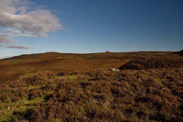
Derwent edge looking towards Coach and Horses with Black Tor on the far left. #derwent #peakdistrict #hiking #nature
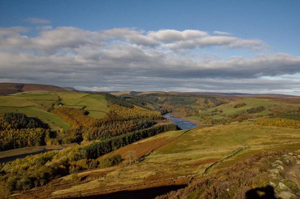
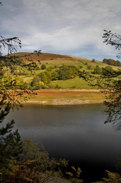
View of Derwent/Ladybower reservoir +- 5m below normal. Note the uncovered remains of one the houses destroyed for the building of the dam. In the background the Derwent Edge towers over the rolling heath and farmland. #peakdistrict #uk #derwent #peakdistrictlandscape #peakdistrictnationalpark #nature #landscape #hiking
Our lovely Solange was on holiday and took a detour to Derwent Pencil Museum with her kids: let's get immersed in the world of #pencils with them, shall we? ✏️
Listen to our latest episode here: https://thecword.show/2025/04/16/s16e03-local-little-museums/
Hathersage is a tourist destination because of the scenery of the Hope and Derwent valleys, its literary connections and easy access by train or road from Sheffield and Manchester. Its visitors come to swim (open-air heated swimming pool, with cafe open all year[15]), climb (Stanage Edge, which with other nearby edges have been the nursery for many famous British rock and mountain climbers) or ramble in its river valleys or hillwalk on its open moors. Hathersage Moor is the site of the Carl Wark hillfort and Higger Tor; both are now within the Sheffield boundary.
Presenting "Remembering Derbyshire"
#Derbyshire
#Peakdistrict
#Hathersage
#Wynnantpass
#Snakepass
#Ladybowerdam
#Derby
#Bakewell
#Buxton
#Castleton
#Landscapephotography
#Derwent
#Bamford
#Mamtor
#Eyam
#Derbyshiredales
#Glossop
#Hathersage
#Edale
#Chatworthhouse
#ai
#aiart
#generativeart
#aiartcommunity
#digitalartwork
The Howden Reservoir is a Y-shaped reservoir, the uppermost of the three in the Upper Derwent Valley, England. The western half of the reservoir lies in Derbyshire and the eastern half is in Sheffield, South Yorkshire; the county border runs through the middle of the reservoir, following the original path of the River Derwent. The longest arm is around 1+1⁄4 mi (2.0 km) in length. The reservoir is bounded at the southern end by Howden Dam; below this, the Derwent flows immediately into Derwent Reservoir and subsequently the Ladybower Reservoir. Other tributaries include the River Westend, Howden Clough and Linch Clough.
Presenting "Remembering Derbyshire"
#Derbyshire
#Peakdistrict
#Hathersage
#Wynnantpass
#Snakepass
#Ladybowerdam
#Derby
#Bakewell
#Buxton
#Castleton
#Landscapephotography
#Derwent
#Bamford
#Mamtor
#Eyam
#Derbyshiredales
#Glossop
#Hathersage
#Edale
#Chatworthhouse
#ai
#aiart
#generativeart
#aiartcommunity
#digitalartwork
For full experience, click the 3 dots top right/Open in browser/Play/Maximize with Sound On.
The Peak District is an upland area in central-northern England, at the southern end of the Pennines. Mostly in Derbyshire, it extends into Cheshire, Greater Manchester, Staffordshire, West Yorkshire and South Yorkshire. It is subdivided into the Dark Peak, moorland dominated by gritstone, and the White Peak, a limestone area with valleys and gorges. The Dark Peak forms an arc on the north, east and west of the district, and the White Peak covers central and southern areas. The highest point is Kinder Scout (2,087 ft (636 m)). Most of the area is within the Peak District National Park, a protected landscape designated in 1951
Presenting "Remembering Derbyshire"
#Derbyshire
#Peakdistrict
#Hathersage
#Wynnantpass
#Snakepass
#Ladybowerdam
#Derby
#Bakewell
#Buxton
#Castleton
#Landscapephotography
#Derwent
#Bamford
#Mamtor
#Eyam
#Derbyshiredales
#Glossop
#Hathersage
#Edale
#Chatworthhouse
#ai
#aiart
#generativeart
#aiartcommunity
#digitalartwork
For full experience, click the 3 dots top right/Open in browser/Play/Maximize with Sound On.
Winnats Pass is a hill pass and limestone gorge in the Peak District of Derbyshire, England. The name is a corruption of 'wind gates' due to the swirling winds through the pass. It lies west of the village of Castleton, in the National Trust's High Peak Estate and the High Peak borough of Derbyshire. The road winds through a cleft, surrounded by high limestone ridges. At the foot of the pass is the entrance to Speedwell Cavern, a karst cave accessed through a flooded lead mine, and which is a popular tourist attraction
Presenting "Remembering Derbyshire"
#Derbyshire
#Peakdistrict
#Hathersage
#Wynnantpass
#Snakepass
#Ladybowerdam
#Derby
#Bakewell
#Buxton
#Castleton
#Landscapephotography
#Derwent
#Bamford
#Mamtor
#Eyam
#Derbyshiredales
#Glossop
#Hathersage
#Edale
#Chatworthhouse
#ai
#aiart
#generativeart
#aiartcommunity
#digitalartwork
A #colouredpencils demonstration I did using #Derwent #Lightfast pencils. #drawing
https://artdragon86.wordpress.com/2020/02/24/coloured-pencils-violin-demonstration/
https://artdragon86.wordpress.com/2020/02/24/coloured-pencils-violin-demonstration/
Client Info
Server: https://mastodon.social
Version: 2025.07
Repository: https://github.com/cyevgeniy/lmst


