#KryvyiRih

2025-11-18

In the distant 2016, when I was a member of an environmental NGO in Kryvyi Rih (Ukraine), I started using satellite Earth Observation data to monitor the condition of large industrial tailings ponds.

At that time, environmental regulations required these storage facilities to be either flooded or at least kept moist to prevent dust storms.
Industrial operators often ignored these rules, leaving huge dry surfaces exposed — which created massive dust pollution affecting nearby communities.

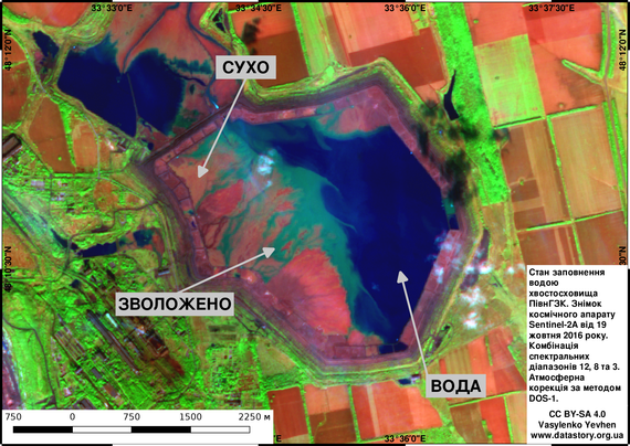
Using Sentinel-2 and Landsat-8 imagery with false-color composites, I developed a simple but effective method to map dry, moist, and water-covered zones of tailings ponds.

Local residents and journalists were absolutely delighted! Industrial companies, on the other hand… reacted very differently 🤣

These maps are from 2016–2017 and show several tailings facilities around #KryvyiRih.

#RemoteSensing #EarthObservation #Sentinel2 #OpenData #EnvironmentalMonitoring
#Tailings #Mining #DustPollution #GIS #QGIS #Ukraine #Landsat
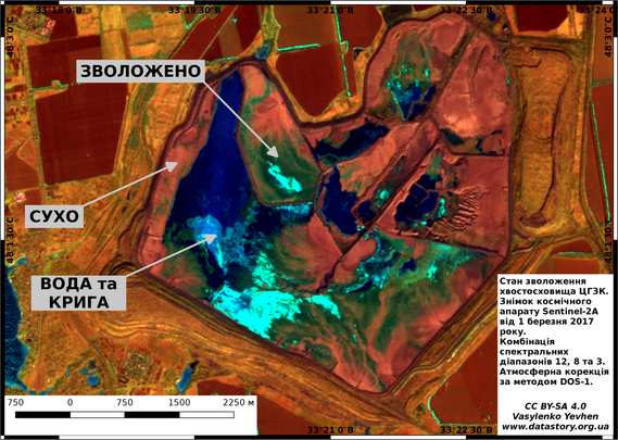
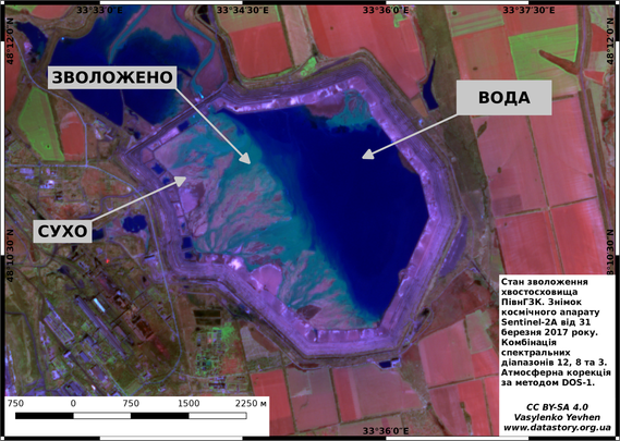
СУХО → DRY
ЗВОЛОЖЕНО → MOIST
ВОДА та КРИГА → WATER & ICE
Moisture conditions of the CGZK tailings storage facility.
Sentinel-2A image from 1 March 2017.
Spectral composite: bands 12, 8, and 3.
Atmospheric correction: DOS-1.Moisture conditions of the Northern Mining & Processing Plant (PivnGZK) tailings storage facility.
Sentinel-2A image from 31 March 2017.
Spectral composite: bands 12, 8, and 3.
Atmospheric correction: DOS-1.Water-filling conditions of the Northern Mining & Processing Plant (PivnGZK) tailings storage facility.
Sentinel-2A image from 19 October 2016.
Spectral composite: bands 12, 8, and 3.
Atmospheric correction: DOS-1.
2025-11-15

📘 A small milestone for my independent research project

I’m honestly a bit shocked.
When I published the first version of my hydrogeochemical monograph on May 27 (v0.72), and then the updated version on August 4 (v0.75), I expected almost no reactions at all.

Today, the combined statistics on Zenodo show:
- 1,400 downloads
- almost 3,000 views

For a niche, highly technical, openly accessible monograph created by one person — this is far beyond anything I imagined.

Thank you to everyone who found the work useful enough to download, save, or read it.
Your interest is the only reason this project keeps growing.

#Geochemistry #Hydrogeology #MineWater #PHREEQC #EnvironmentalGeochemistry #Groundwater #Metasomatism #RStats #QGIS #OpenScience #IndependentResearch #SvystunovaGully #KryvyiRih #WaterPollution #Contamination #Mining #Zenodo

(Full Zenodo record — in the ALT of the second image, for anyone interested.)

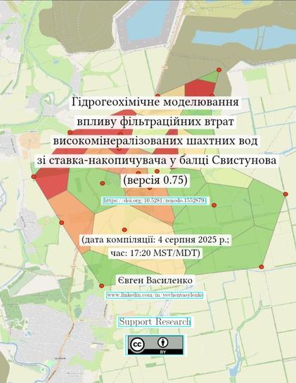
Zenodo's statistics for 2025, Nov. 15.Title page of the monograph published on Zenodo (https://zenodo.org/records/16741148)
2025-11-11

🏙️ The Hellish Trade Zones
(Ukrainian: “Торговельні пекельні зони”)

An older piece from 2017 — but still relevant today.
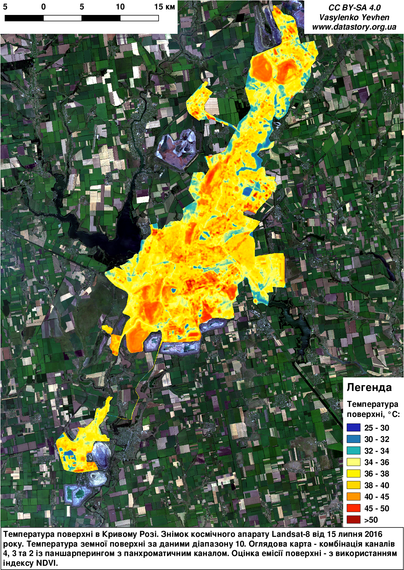
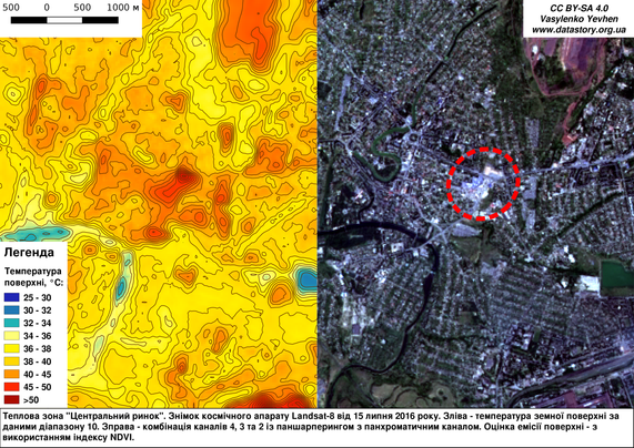
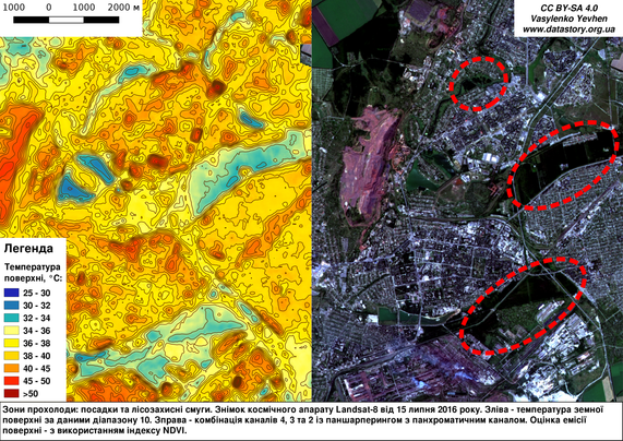
Using Landsat-8 thermal imagery, I explored how urban heat islands form in large commercial and industrial areas completely devoid of vegetation.

These “hellish trade zones” show surface temperatures exceeding 45–50 °C, while nearby shelterbelts and green spaces remain much cooler.
The visual storytelling approach — combining satellite data, maps, and simple explanations — helped raise public awareness about urban greening and environmental health in my city.

📍 Location: Kryvyi Rih, Ukraine
🛰️ Data: Landsat-8 (July 15, 2016), thermal band 10 + NDVI
🔗 More: datastory.org.ua/%d1%82%d0%be%

#UrbanHeatIsland #RemoteSensing #Landsat #UrbanEcology #ClimateChange #EnvironmentalData #UrbanGreening #Geospatial #GIScience #OpenScience #DataVisualization #Ukraine #Sustainability #KryvyiRih #UrbanHealth

Surface temperature map of Kryvyi Rih derived from Landsat-8 thermal band 10.“Central Market” — one of the city’s hottest urban spots, over 45 °C.Cooler zones correspond to shelterbelts and forest strips that mitigate local heat.
2025-11-10

🧪 Mine water + fresh water ≠ simple average

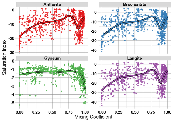
When high mineralized mine waters mix with fresh groundwater, mineral reactions don’t behave linearly.

The graphs below show how saturation indices for selected minerals respond to dilution:
🔹 Copper sulfates (Antlerite, Brochantite, Langite) display clear peaks and drops.
🔹 Gypsum remains undersaturated — yet falls sharply at high dilution.

Each “dip” or “window” reflects a short-lived equilibrium where new mineral phases may form or dissolve — revealing the hidden dynamics of technogenic metasomatism in aquifer systems.

📖 Draft monograph (v0.75) available on Zenodo:
🔗 zenodo.org/records/16741148

#Geochemistry #Hydrogeology #MineWater #PHREEQC #EnvironmentalGeochemistry #Groundwater #Metasomatism #RStats #QGIS #OpenScience #IndependentResearch #SvystunovaGully #KryvyiRih #WaterPollution #Contamination #Mining

Four scatter plots showing changes in mineral saturation indices (Antlerite, Brochantite, Gypsum, Langite) versus mixing coefficient between mine and fresh waters. Each graph includes hundreds of data points and a smooth trend line. Copper sulfates display strong non-linear peaks and drops, while gypsum remains slightly undersaturated across all dilution levels.
2025-11-10

🌬️ Dust for Everybody, Free of Charge…!

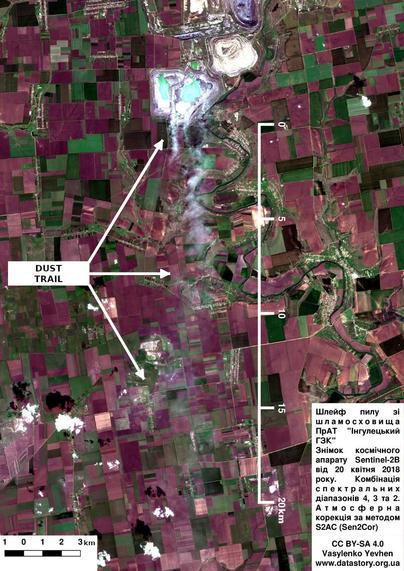
This is the English translation of my earlier article analyzing the recurring dust storms caused by tailings and waste dumps in the Kryvyi Rih Iron Ore Basin.

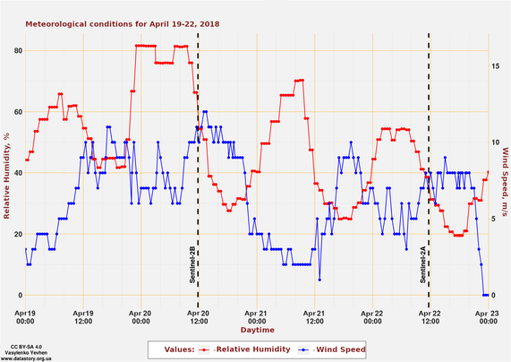
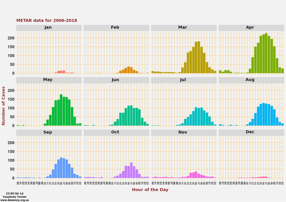
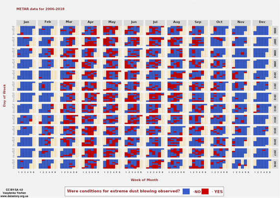
Using large meteorological datasets and satellite observations, I demonstrated that extreme dust emissions coincide with the region’s dry spring winds — a seasonal pattern that persists year after year.

The findings challenged local industrial “dust control” programs, showing that their methods do not reflect real climatic conditions.
The publication sparked a wide public debate, meetings of the municipal working group, and eventually led to updates in enterprise dust-suppression policies.

📎 The article is here:
datastory.org.ua/dust-for-ever

#EnvironmentalScience #RemoteSensing #AirPollution #DustEmission #MiningImpact #ClimateData #KryvyiRih #IndependentResearch #OpenScience #Sustainability #RStats #QGIS #METAR #NOAA

Dust trails from the tailings ponds of the “Ingulets Mining and Processing Plant”Meteorological conditions in Kryvyi Rih region on April 19-22, 2018Number of cases of observed wind speed “7 m/s and more” combined with relative humidity “60% and less”Days when meteorological conditions conducive to extreme dust blowing from tailings ponds were observed
2025-11-10

🌊 Hydrological patterns in the Inhulets River Basin

I’m working on a large-scale study of the technogenic impact on the Inhulets River system (Ukraine).
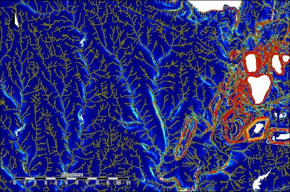
The workflow combines R + SAGA GIS + QGIS for geomorphometric and hydrological analysis.

Over the past week, I’ve been refining digital elevation models and tracing surface runoff connectivity — not an easy task in a region reshaped by century of mining.

The map below shows one of the calmest and most “well-behaved” areas, far from the mining zone.
As for the drainage network over the mining areas… let’s just say it’s geological chaos down there 😄

🛰️ Data: Copernicus DEM (GLO-30)
🧭 Tools: SAGA GIS (Terrain Analysis), R, QGIS

#Hydrology #Geomorphometry #SAGAGIS #QGIS #RStats #DEM #GIScience #EnvironmentalModeling #MiningImpact #Geodata #InhuletsRiver #Ukraine #KryvyiRih #Copernicus #CopernicusDem

Extracted drainage network and real surface area patterns for the western part of the Inhulets Basin. Generated in SAGA GIS using the Terrain Analysis module.
2025-11-09

🌳 Random Forests and Living Trees

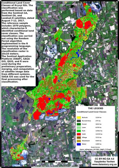
English translation of my earlier article on applying satellite imagery and machine learning to map urban land cover.

What started as a local research project in Kryvyi Rih turned into something much larger — the results sparked a heated discussion among residents, officials, and industry representatives about the real condition of green buffers around large industrial sites.

The methodology developed during that work is still being used today — adapted for new environmental and urban projects.

🔗 datastory.org.ua/random-forest

#RemoteSensing #MachineLearning #LandCoverMapping #UrbanEcology #EnvironmentalMonitoring #RandomForest #GeospatialAnalysis #GIS #RStats #SAGAGIS #QGIS #IndependentResearch #OpenSource #EnvironmentalDataScience #KryvyiRih #LULC

Map of Kryvyi Rih showing land cover classification (2017) produced with Sentinel-1A, Sentinel-2A, and Landsat-8 data using the Random Forest algorithm in R. Green areas indicate vegetation; red tones show industrial and built-up zones.
2025-09-07

Ukraine’s main government building is hit as Russia ramps up attacks.

“For the first time, the government building, roof and upper floors were damaged due to an enemy attack,” said Ukrainian Prime Minister Yulia Svyrydenko.

Moscow fired more than 800 drones and 13 missiles at Kyiv, Odesa, Kremenchuk, Kryvyi Rih and Zaporizhzhia, Ukrainian officials said.

mediafaro.org/article/20250907

#Ukraine #Russia #WarInUkraine #Kyiv #Odesa #Kremenchuk #KryvyiRih #Zaporizhzhia

DionyZack 🍉✊🏽♀️🌿dionyzack.bsky.social@bsky.brid.gy
2025-09-03

🕸glané sur le net🕸 Ukraine. Comment travaillent les enseignant·es à 60 kilomètres du front: Malgré le danger permanent et le manque d'enseignant·es, les éducateurs et les éducatrices de la ville frontalière de Kryvyi Rih continuent… #Ukraine #Éducation #Enseignants #KryvyiRih #SoutienÉducatif

Ukraine. Comment travaillent l...

Associazione Peacelinkpeacelink@sociale.network
2025-08-17

#TCC #Ucraina
Tra il 30 giugno e il 7 luglio 2025, la Russia ha effettuato una serie di attacchi con droni contro centri di reclutamento (TCC) nelle città di #Kharkiv, #Zaporizhzhia, #Poltava, #KryvyiRih e #Kremenchuk.
Gli obiettivi: danneggiare le strutture, provocare vittime e interrompere le procedure di mobilitazione. il Ministero della Difesa sta promuovendo la digitalizzazione di servizi e l’accesso remoto per ridurre la necessità di presenza fisica nei centri.

#WarInUkraine
#КривийРіг
#KryvyiRih

У Кривому Розі справжнє пекло, зникло світло: у місті щонайменше 20 прильотів

#WarInUkraine
#КривийРіг
#KryvyiRih

Russian missile strike hit the city of Kryvyi Rih

鉄道事故関連ニュースtrainaccident@news.hostdon.ne.jp
2025-06-24

(Geminiで要約)
クリヴィー・リフで路面電車が脱線寸前に
2025年6月20日、ウクライナのクリヴィー・リフ市ソボルノスティ通りで、路面電車が環状線で脱線寸前になる事故が発生しました。この情報はTelegramチャンネル「トルハ・クリヴィー・リフ」が報じています。
事故発生時に乗客がいたかどうかは不明です。
クリヴィー・リフの路面電車は歴史が長いものの、一部の車両はソビエト時代に製造されたもので、外観や技術的な状態から老朽化が進んでいることがわかります。そのため、古い電気交通機関による事故が頻繁に発生しています。 #KryvyiRih
ukr.net/ru/news/details/dnipro

鉄道事故関連ニュースtrainaccident@news.hostdon.ne.jp
2025-06-23

(Geminiで要約)
ウクライナ、クルィヴィーイ・リーフ市で路面電車が脱線し木に衝突、4名負傷
2024年6月22日、ウクライナのクルィヴィーイ・リーフ市で路面電車が脱線し、街路樹に衝突する事故が発生しました。この事故により、4人が負傷しました。
事故は、Svyato-Mykolaivska通りで発生。路面電車がカーブを曲がる際に脱線し、制御を失って道路脇の木に衝突しました。衝突の瞬間は監視カメラに捉えられており、路面電車が突然軌道を外れて木に激突する様子が記録されています。
負傷した4人のうち、2人は病院での治療が必要と診断され、残りの2人は現場で応急処置を受けました。地元の警察が事故原因の詳細な調査を進めています。 #KryvyiRih
dp.informator.ua/ru/v-krivom-r

鉄道事故関連ニュースtrainaccident@news.hostdon.ne.jp
2025-06-23

(Geminiで要約)
クルィヴィーイ・リーフ市で路面電車が脱線し木に衝突、運転手が重体、乗客も負傷
2025年6月19日、クルィヴィーイ・リーフ市で路面電車が脱線し木に衝突する事故が発生しました。この事故により、女性運転手が重体となり、乗客も負傷しました。 #KryvyiRih
ukr.net/news/details/dnipro/11

鉄道事故関連ニュースtrainaccident@news.hostdon.ne.jp
2025-06-23

(Geminiで要約)
クリヴィー・リフで路面電車が脱線、負傷者あり
ウクライナのクリヴィー・リフ市で、路面電車がスピードを出したまま脱線する事故が発生しました。この事故により、少なくとも1名が負傷しました。
事故は5月27日の午後に発生し、路面電車がカーブを曲がる際に線路から外れ、近くの電柱に衝突しました。衝突の衝撃で、車両前部が大きく損傷しました。
負傷した乗客は病院に搬送されましたが、命に別状はないと報じられています。事故原因については現在調査中ですが、速度超過が関係している可能性が指摘されています。
この事故により、路面電車の運行に一時的な影響が出ました。 #KryvyiRih
hirchytsya.com.ua/u-kryvomu-ro

鉄道事故関連ニュースtrainaccident@news.hostdon.ne.jp
2025-06-23

(Geminiで要約)
クリヴィー・リフで路面電車が脱線し木に衝突、負傷者多数
ウクライナのクリヴィー・リフ市で、数十人を乗せた路面電車がレールを外れて木に衝突する事故が発生しました。この事故により、多数の負傷者が出ています。
公開された写真や動画からは、路面電車が大きく損傷している様子がうかがえます。事故原因など詳細は報じられていませんが、地元当局が調査を進めているものとみられます。負傷者の正確な人数や容態についても、現時点では不明です。 #KryvyiRih
incident.obozrevatel.com/crime

鉄道事故関連ニュースtrainaccident@news.hostdon.ne.jp
2025-06-23

(Geminiで要約)
クリヴィー・リフ市で路面電車が脱線、運転手がキャビンに挟まれる事故が発生
2024年6月22日、土曜日にクリヴィー・リフ市ユゴク地区で路面電車が脱線し、運転手がキャビンに挟まれる事故が発生しました。
この事故は、ユゴク地区の第14学校付近で発生し、路面電車は完全に線路を逸脱しました。事故後、救助隊が現場に駆けつけ、特殊な道具を使って運転手をキャビンから救出しました。救出された運転手は、すぐに病院に搬送されたとのことです。
事故原因については、現在調査中です。 #KryvyiRih
svoi.kr.ua/ru/novosti/tramvay-

2025-04-23

Wednesday, April 23 2025

The Kyiv Independent [unofficial] Russia’s war against Ukraine A view of damage after a Russian guided aerial bomb hit a residential neighborhood in Zaporizhzhia on April 22, 2025. The Russian strike killed a 69-year-old woman and injured 38 others, including children. (Zaporizhzhia Regional Military Administration/Handout/Anadolu via Getty Images) Putin offers US to freeze Ukraine war along current front line, FT reports. This could be the first formal indication from Russian […]

activitypub.writeworks.uk/2025

Smoke rises over the site of reported explosions at a Russian weapons arsenal in Vladimir Oblast on April 22, 2025
2025-04-16

#Ukraine #Zelensky #KryvyiRih

"Ukraine's Zelensky Honours Victims of Russian Strike In Hometown | Subscribe to Firstpost | N18G" [ ± 1min]
by Firstpost

youtube.com/shorts/ygvlKNVGv3c

Quote by Fp:
"Apr 12, 2025
Ukrainian President Volodymyr Zelensky visited his hometown, Kryvyi Rih, on April 11, 2025, after a deadly Russian missile strike killed 19 people, including children. During the visit, he placed flowers at the site to honour the victims and show solidarity with the grieving community. He also met with wounded soldiers in a nearby hospital, thanking them for their bravery and handing out medals."

#SlavaUkraini ! #HeroyamSláva!
#Crush the #RussianTerroristState

Client Info

Server: https://mastodon.social
Version: 2025.07
Repository: https://github.com/cyevgeniy/lmst