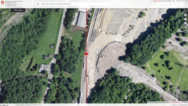
3D reconstruction of Birch Glacier collapse: Last Wednesday, the #Birch Glacier in Switzerland collapsed beneath debris, burying parts of the evacuated village of #Blatten. Using #Swisstopo’s openly available #RapidMapping geodata, professionals quickly produced detailed pre- and post-event...
https://spatialists.ch/posts/2025/06-01-3d-reconstruction-of-birch-glacier-collapse/ #GIS #GISchat #geospatial #SwissGIS
#RapidMapping
Storymap sur le cyclone Chido à #Mayotte
avec les images Pléiades Néo (Airbus) mis à disposition par @ignfrance et les ressources mises à disposition par le GDACS / @cnes #MaCarteIGN
#Copernicus #RapidMapping - via @jmviglino
https://macarte.ign.fr/carte/PK2rNd/Cyclone-tropical-a-Mayotte
### Unwetterfolgen Schweiz
Wer sich für die Folgen der letzten #Unwetter in der #Schweiz interessiert, bekommt hier eine gute Bildquelle.
"#Rapid #Mapping ist eine Dienstleistung des Bundes zur zeitgerechten Erhebung und Bereitstellung von Geodaten (z. B. Luft- oder Satellitenbilder) für die Ereignisbewältigung und –dokumention im Fall von Naturereignissen. Die zuständigen Stellen auf allen föderalen Stufen (Bund, Kantone, Gemeinden) werden bei der Beurteilung und Dokumentation der Auswirkungen von Naturereignissen aktiv unterstützt."
https://www.rapidmapping.admin.ch/index_de.html
Aktuell gibt es Bilder zu folgenden Ereignissen:
- Hochwasser #Wallis
- Hochwasser/#Rutschungen #Tessin
- Hochwasser- / #Murgangsituation im #Misox #Kanton #Graubünden
Die Autobahn #A13 ist übrigens inzwischen wieder vollständig wiederhergestellt.
https://blog.astra.admin.ch/wir-muessen-auch-das-unvorstellbare-in-betracht-ziehen/
#Unwetterfolgen #Unwetter #Schweiz #Erdrutsche #Murgänge #Klimawandel #Klimakrise #Starkregen #BAFU #swisstopo #Hochwasser #Karten #Landkarten #RapidMapping
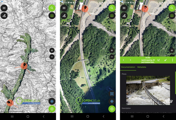
The impacted list is long, and the work is immense, but we can help.
Photographing damaged houses and infrastructure is vital for effective disaster response. This helps assess damage, plan rescues, and allocate resources efficiently. Documenting damaged vehicles also adds valuable insights. @qfield Rapid Mapper empowers volunteer citizens to contribute to quicker, coordinated emergency responses.
Join us in making a difference! https://buff.ly/3zyg1aS
RT by @CopernicusEU: The @CopernicusEMS #RapidMapping Module, when activated, delivers monitoring products for assessing the damage caused by floods, wildfires, earthquakes, etc.
🔗https://emergency.copernicus.eu/mapping/ems/rapid-mapping-portfolio
⬇️Image of flooded areas in eastern Latvia in April 2023 (#EMSR657)
[2024-03-14 11:44 UTC]
#Hochwasser #Überflutung #Flut #Flood #Weather #HeavyRain
Due to strong #jetstream which, since end of November, dumped one moist Atlantic Low after the other over middle and Northern Germany, her Northern rivers were overflowing since before Christmas. Newsreporting and live ticker never said how big the actual affected area is. But it felt like a third of the country at least – just from the persistent presence in my news feed and in my mind.
Today, I pondered how I could get figures for hectare if journalists don't report them... first, I thought of #NASA GRACE drought monitoring which could maybe be used in reverse or whatever. But then I found something better: Germany had activated @CopernicusEU to monitor several rivers in their program #RapidMapping. Since the activation, #Sentinel 🛰️ takes a photo every day and the software guesstimates flooded hectare, flooded roads, rails and affected number of people.
You can find your own country's past or active Copernicus activations here https://rapidmapping.emergency.copernicus.eu/
Germany's current one for Lower Saxony is here https://rapidmapping.emergency.copernicus.eu/EMSR712/download
The hectares flooded, 46365, appear to be 0.12% of the country's area 357600 km2
Okay. Not a third of the country, then 😁
RT @CopernicusEMS: #InternationalFirefightersDay
Today our thoughts are with the firemen & firewomen community!👨🚒
It brings us immense pride to have contributed to 6⃣5⃣9⃣ #RapidMapping operations worldwide🌍since 2012 in support of emergency management activities
#rescEU https://t.co/giMhAq2uJ9
🐦🔗: https://n.respublicae.eu/eu_echo/status/1654044272700583938
RT @GAF_Munich: Sucessful Kick-Off of the new working period & 6-year contract of the @CopernicusEMS #rapidmapping #EmergencyService & greetings from all participants of the consortium of #EU #EarthObservation companies under the lead of @e_geos last week in #Rome @EU_ScienceHub @EU_Commission
🐦🔗: https://n.respublicae.eu/CopernicusEU/status/1638500003659370497
The #EUSpace 🇪🇺🛰️ Programme is playing an important role in supporting emergency responders in #Türkiye 🇹🇷
So far, the #RapidMapping module of @CopernicusEMS has delivered 5⃣1⃣ maps
⬇️Kahramanmaras🗺️
More about the #EMSR648 activation👇
http://emergency.copernicus.eu/EMSR648
🐦🔗: https://n.respublicae.eu/defis_eu/status/1623983069328732161
The #EUSpace 🇪🇺🛰️ Programme is playing an important role in supporting emergency responders in #Türkiye 🇹🇷
So far, the #RapidMapping module of @CopernicusEMS has delivered 5⃣1⃣ maps
⬇️Kahramanmaras🗺️
More about the #EMSR648 activation👇
https://emergency.copernicus.eu/mapping/list-of-components/EMSR648
🐦🔗: https://n.respublicae.eu/EU_ScienceHub/status/1623983580023078912
.@CopernicusEMS ha fornito dati cruciali per aiutare i soccorritori a valutare i danni della frana a #Casamicciola, sull'isola di #Ischia.
#EMSR643 #CEMS
👇
http://emergency.copernicus.eu/EMSR643
RT @CopernicusEMS: #CEMS #Highlight of the past week
Within the #EMSR643 #RapidMapping activation, our new Aerial Component🛩️ provided key data to help emergency responders assess the damage from the mudflow in #Casamicciola, on the island of #Ischia🇮🇹
More at👇
🔗https…
🐦🔗: https://n.respublicae.eu/i/web/status/1599717284058042370
#CEMS #Highlight of the past week
Within the #EMSR643 #RapidMapping activation, our new Aerial Component🛩️ provided key data to help emergency responders assess the damage from the mudflow in #Casamicciola, on the island of #Ischia🇮🇹
More at👇
🔗https://emergency.copernicus.eu/EMSR643
🐦🔗: https://n.respublicae.eu/i/web/status/1599668402993315843
RT @CopernicusEMS: #CEMS activities during the #2022WildfireCrisis🔥
📍Focus: #Greece🇬🇷
Our #RapidMapping service was activated 1⃣1⃣ times by @GSCP_GR between 1 June & 30 September 2022 and delivered a total of 3⃣2⃣ maps💡
RT @CopernicusEMS: #CEMS activities during the #2022WildfireCrisis🔥
📍Focus: #Germany🇩🇪
Our #RapidMapping service was activated 5⃣ times by @BBK_Bund between 1 June & 30 September 2022 and delivered a total of 1⃣3⃣ maps💡
RT @CopernicusEMS: #CEMS activities during the #2022WildfireCrisis🔥
📍Focus: #Italy🇮🇹
Our #RapidMapping service was activated 3⃣ times by @DPCgov between 1 June & 30 September 2022 and delivered a total of 8⃣ maps💡
Read our latest Information Bulletin at👇
https://emergency.copernicus.eu/mapping/ems/information-bulletin-163-exceptional-mobilisation-copernicus-emergency-management-service-during
🐦🔗: https://nitter.eu/CopernicusEU/status/1595722991802925056
RT @CopernicusEMS: #CEMS activities during the #2022WildfireCrisis🔥
📍Focus: #France🇫🇷
Our #RapidMapping service was activated 3⃣ times by @SecCivileFrance between 1 June & 30 September 2022 and delivered a total of 3⃣3⃣ maps💡
🐦🔗: https://nitter.eu/CopernicusEU/status/1595666492842016768
RT @CopernicusEMS: #CEMS activities during the #2022WildfireCrisis🔥
📍Focus: #Spain🇪🇸
Our #RapidMapping and Risk & Recovery Mapping #RRM colleagues were activated 22 times by @proteccioncivil between 1 June & 30 September 2022, delivering a total of 146 maps
🐦🔗: https://nitter.eu/CopernicusEU/status/1595308996247814145
RT @CopernicusEMS: Are you interested in learning more about the possible future evolution of the #CEMS components which enabled us to monitor the 2022 #WildfireCrisis❓
🔥#EFFIS
⏲️#RapidMapping
🗺️Risk & Recovery Mapping #RRM
Register for the #CEMS General Assembly at👇
https://emergency.copernicus.eu/mapping/ems/cems-assembly-2022
🐦🔗: https://nitter.eu/EU_ScienceHub/status/1573296071409041408
RT @CopernicusEMS: Are you interested in learning more about the possible future evolution of the #CEMS components which enabled us to monitor the 2022 #WildfireCrisis❓
🔥#EFFIS
⏲️#RapidMapping
🗺️Risk & Recovery Mapping #RRM
Register for the #CEMS General Assembly at👇
https://emergency.copernicus.eu/mapping/ems/cems-assembly-2022
🐦🔗: https://nitter.eu/CopernicusEU/status/1573226621133365250
RT @CopernicusEMS: Since the beginning of July 2022, we received 3⃣9⃣ activations as a consequence of the #WildfireCrisis that affected Europe
➡️For the first time in 8⃣ weeks, our #RapidMapping had no activation🗺️ in progress during the past weekend‼️
🔗 https://emergency.copernicus.eu/mapping/list-of-activations-rapid
🐦🔗: https://nitter.eu/CopernicusEU/status/1564193064851218432

