Peak beak
https://www.universalhub.com/2025/peak-beak
#Quincy #Squantum #birds #ibis #egret #ShesSeenAFew
#Squantum
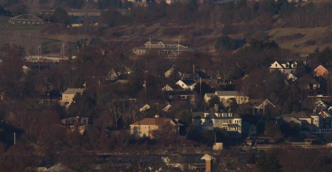
Spectacle Island of Boston Harbor Islands National Park and the Squantum section of Quincy MA photographed from Buck Hill. The landscape fools the eyes here as there are several miles of Boston Harbor which cannot be seen, making this appear as one continuous land mass. Squantum is a little over six miles from Buck Hill while Spectacle Island is over eleven miles. On Spectacle Island, the visitor center building can clearly be seen, as can the dock out in front (left in the photo) with light posts. The frame of a special event tent on the island can be seen to the upper left. At the top of the frame, some of the stone seawall for Deer Island can be seen.
I am including a second image that includes a key to the structures that I have identified in this post.
1 - Spectacle Island Visitor Center
2 - Spectacle Island dock
3 - Spectacle Island tent frame
4 - 132 Crabtree Rd, Quincy MA
5 - 124 Crabtree Rd, Quincy MA
6 - 94 Crabtree Rd, Quincy MA
7 - 25 Woodbriar Rd, Quincy MA
8 - 78 Knollwood Rd, Quincy MA
9 - 72 Knollwood Rd, Quincy MA
10 - 75 Knollwood Rd, Quincy MA
11 - 13 Hillcrest Rd, Quincy MA
12 - 84 Knollwood Dr, Quincy MA
13 - 49 Sonoma Rd, Quincy MA
#BuckHill #BlueHills #BlueHillsReservation #Boston #BostonMA #BostonHarborIslands #Quincy #QunicyMA #Squantum #SquantumMA #Spectacle #SpectacleIsland #Landscape #LandscapePhotography #Photography #LongDistanceObservations #OlympusEM5 #CanonFD #500mm
A bizarre #sedimentary feature
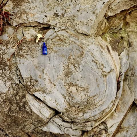
Some layers in the #Neoproterozoic #Squantum Member of the #Roxbury #Conglomerate have been rolled up like a pie crust, into a tube. If this were a #tillite, as it once was thought to be, then it could have been caused by the drag of a #Gaskiers #glacier over the till. These rocks are mostly interpreted as deposited by submarine debris flows these days, in which case they could’ve been deformed during a slump and flow. Site of a field trip for #UMassBoston.
A small #outcrop of the #Squantum Member of the #Roxbury #Conglomerate
These #rocks are in the #BostonBay Group, which is currently dated to #Neoproterozoic. The Squantum Member was interpreted as a #tillite, possibly associated with the #Gaskiers #glaciation, although there a scant signs like scratched pebbles or faceted cobbles. It is currently commonly interpreted as a #debrite (debris flow). Details in captions.
#geology #glacier #turbidite #Quincy #Boston #Massachusetts #NewEngland
View about eastward over #Quincy Bay, #Squantum on the left, just south of #Boston, #Massachusetts USA
#NewEngland #Fujifilm my #photo #landscape
18/2 @ 5.6 1/950 s ISO 200 X-H1
Anomalous pebble in layered #sedimentary #rock
An angular pebble is conformably surrounded by argillaceous and sandy layers in this #photograph of the #Neoproterozoic #Squantum Member of the #Roxbury Conglomerate. The wide range of clast sizes led to an interpretation as a #glacial #tillite thru the 1970s, but the Squantum Member is now mostly interpreted as a #debrisFlow (#debrite or #turbidite). My #photo.
Deformed bedding in meta#sedimentary #rocks
The horizontal bedding of the #Squantum Member of the #Roxbury Conglomerate (#Neoproterozoic, #Boston Bay Group) has been disturbed locally.
In the #glacial #tillite interpretation of the Squantum (favored through at least the 1970s), the distortion might be caused by glaciotectonic drag at the ice base. The current interpretation as a #debrite or #turbidite would probably attribute the deformations to synsedimentary slumping. My #photo. #fieldTrip
Rapid changes in #clast size in #sedimentary #rocks
The #Neoproterozoic #Squantum Member of the #Roxbury Conglomerate (#Boston Bay Group) transitions from sandstone, to almost-clast-supported conglomerate, to laminated argillite…in about 25 cm. Fifty years ago, it was interpreted as a #glacial deposit and called the Squantum #Tillite, presumably associated with the #Gaskiers Glaciation. Paucity of evidence (e.g., few scratches or faceted clasts) suggests a debris flow. My #photo.
The #glacier went that-a-way
The #striations on this face of the #Ediacaran (ca. 560 Ma) #Squantum Member of the #Roxbury #Conglomerate were probably left by the #Pleistocene #Laurentide ice sheet, which retreated ca. 12 ka. The striations have the right orientation, from northwest to southeast.
The Squantum Member was once interpreted as a (#glacial) #tillite. The most common contemporary model is a peri-#Gondwana #debrite (#turbidite).
Interbedded argillaceous & tuffaceous #sediments
These photos are of #Cambridge #Argillite, exposed above the #Squantum Member of the #Roxbury Conglomerate (#Neoproterozoic). Prior to the 1970s or so, the Squantum Member was interpreted as #glacial sediments; it's now broadly interpreted as debris flows, with the Cambridge being distal turbidites overlying it. I lead a field trip here for #UMassBoston. See captions.
#outcrop #fieldTrip #photo #rocks #tuff #Fufjilm #Venus 65mm #macro #Quincy


