upgraded my processor just from an i5-6400 to an i5-12000 and repeated an ODM map of 350 images that had taken 90 minutes, it took 25 minutes! amazing! Wish I'd done this before I processed 18 jobs of total nearly 7,000 images earlier this week
#WebODM
been runnning lots of huge datasets on #WebODM and started to have problems. This page was a big help for someone who does not understand Docker! I did have to look up the commands to run them from the command line, but it all looks to be running a lot smoother again now.
OpenDroneMap/WebODM
V2.8.3
---
- Improve console output management
- Avoid locking users out of a map with an invalid crop
- Configurable worker count
- Overhaul/cleanup of main Dockerfile
- Multispectral fixes + crop fixes
- Fix thermal RGB exports
---
OpenDroneMap/WebODM
V2.8.1
---
- Cleanup empty projects when quota = 0
- Orphaned project folders handling
- Plugin enable/disable "fix"
- Fix layer ordering in project map view, display annotations only for first task
- Intersection over area project map display
- Cluster mode utils
- Camera thumb zoom
- Pan support, mobile support for zoom/pan
---
OpenDroneMap/WebODM
V2.7.3
---
- Respect processing nodes visibility permissions
- Pass requests to Gunicorn via HTTP 1.1
- Replace zipfly --> zipstream-ng
- Share Project Links
---
WebODM auto-align feature - looks pretty neat, this software is amazing
OpenDroneMap/WebODM
V2.7.2
---
- Add user search
- Add hosted instance link alert
- Add 172.16 /12 as Private IP Range
- Fix thermal layer name in project map view, add compact feature, onboarding settings
---
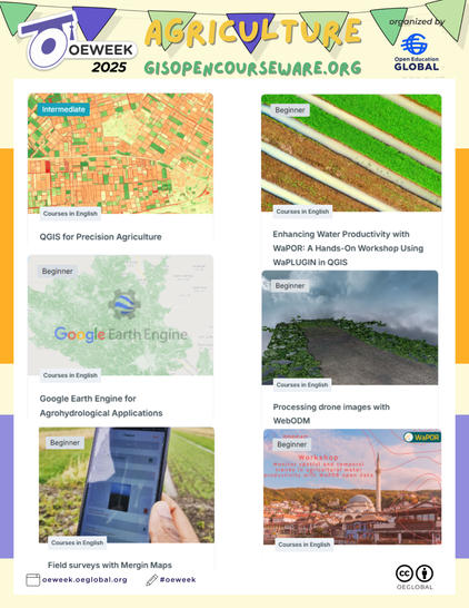
Day 4 of #OpenEducationWeek 2025! Highlighting courses for #agriculture: https://courses.gisopencourseware.org/
🌾 #QGIS for Precision Agriculture
💧 Enhancing Water Productivity with WaPOR #WaPlugin in QGIS
🌐 #GEE for Agrohydrological Applications
🚁 Processing Drone Images with #WebODM @OpenDroneMap
📱 Field Surveys with @merginmaps
OpenDroneMap/WebODM
V2.7.1
---
- Update README.md
- Geolocation file download, task thumbnails, task alignment support
...
---
OpenDroneMap/WebODM
V2.7.0
---
- Simultaneous map items display and swipe view
- Fix contours, objdetect plugins
- Handle PIL decompression bomb error
...
---
OpenDroneMap/WebODM [Windows native]
v2.7.0 Build 111
---
- Update WebODM to v2.7.0 (main)
- Update NodeODM to v3.5.4 (tag)
---
#OpenDroneMap #WebODM #WebODMForWindowsNative #ODMUpdatesBot
OpenDroneMap/WebODM
V2.6.0
---
- Update gunicorn to 19.8.0 fixing
- AI Object Detection (GeoDeep)
- Add point cloud resampling export
- Add worker max threads
- Update GeoDeep, more object detection classes
...
---
OpenDroneMap/WebODM
V2.5.7
---
- Add full screen button to plot gps map view
- Add warning message when 999 images are selected
- Dronedb plugin fix
- Handle import chunk retries
- Reduce memory usage in DEMs rasterization
- More memory optimizations for RGB/HSV conversion, duplicate filename uploads
- More consistent hillshading across zoom levels
- JS bundle optimization, placeholder loading screens
...
---
OpenDroneMap/WebODM
V2.5.6
---
- group installations instructions
- Update README.md
- feat: instructions of GPU acceleration
- unitBackward fix
- Create BIGTIFF output during export if needed
- Hide Add Project button when user doesn't have permissions
- Public edits
- Links for 3D meshes support
...
---
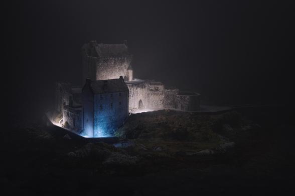
Eilean Donan
The cliché of castles, but I think I've made a distinctive photo of it.
200 frames from all around shot on the droneybird, processed in WebODM, re-lit and camera parameters chosen in Blender and finished in Luminar Neo.
Prints, cards and more via the website: https://shiny.photo/photo/Eilean-Donan-2d46ad8e4088e90fb041e64a5bc486a7
#photography #photogrammetry #3d #blender #scotland #castle #landscape #fog #night #highlands #WebODM @OpenDroneMap
OpenDroneMap/WebODM [Windows native]
v2.5.5 Build 106
---
- Update WebODM to v2.5.5 (main)
- Update NodeODM to v3.5.3 (tag)
---
#OpenDroneMap #WebODM #WebODMForWindowsNative #ODMUpdatesBot
Heritage in Tarmac
A tribute to a favoured old road - three fragments of the historical Devil's Elbow route through Glenshee presented as a triptych.
I flew the droneybird up and down over a mile of the A93, used #WebODM to build a 3D model of the glen, Blender to compose and relight each frame consistently and finished in Luminar Neo.
#photography #photogrammetry #Blender #art #scotland #road #heritage #perthshire @OpenDroneMap
OpenDroneMap/WebODM
V2.5.5
---
- Add flight path preview when selecting images
- Minor fix for lightning plugin
- Restore the Cesium Ion Plugin
- Fix docker-compose command
- Add plugin to get align from WCS service (geoserver)
- Safari Fixes, delete fix
...
---
Fedizens!
Please help us figure out if folks would appreciate automatic failover from other feature types to ORB when there is an Out-Of-Memory (OOM) situation to help ensure you get a processed dataset and can continue to troubleshoot after.
Fediverse Poll included for folks not part of our Discourse Community yet, and link to our Community below:
https://community.opendronemap.org/t/request-for-feedback-would-you-want-automatic-graceful-failover-to-orb/21134


