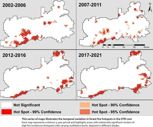
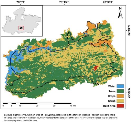
Environmental & Anthropogenic Influences On Fire Patterns In Tropical Dry Deciduous Forests
--
https://doi.org/10.1038/s41598-025-98051-7 <-- shared paper
--
#GIS #spatial #mapping #wildfire #fire #busgfire #nvironmental #anthropogenic #influences #humanimpacts #deciduous #forests #firepatterns #spatialanalysis #tropical #ecosystems #management #tree #vegetation #spatiotemporal #hotspots #india #Satpura #tiger #reserve #ecogeography #geography #factors #parameters #drivers #temperature #precipitation #rainfall #model #modeling #bayesian #framework #slope #water #hydrology #infrastructure #mitigation #monitoring #preparedness #forestfires
#anthropogenic
Alteration of Catchments and Rivers, and the Effect on Floods: An Overview of Processes and Restoration Actions: The bibliographic review performed here aimed to assess the degradation of the natural regulation services of watersheds, which allowed us to identify significant alterations to runoff and streamflow. #flood #anthropogenic #water #flooding https://www.mdpi.com/2073-4441/17/8/1177
Alteration of Catchments and Rivers, and the Effect on Floods: An Overview of Processes and Restoration Actions: The bibliographic review performed here aimed to assess the degradation of the natural regulation services of watersheds, which allowed us to identify significant alterations to runoff and streamflow. #flood #anthropogenic #water #flooding https://www.mdpi.com/2073-4441/17/8/1177
Latitudinal gradients of snow contamination in the Rocky Mountains associated with anthropogenic sources. #pollution #water #snow #anthropogenic https://www.sciencedirect.com/science/article/abs/pii/S0269749125004671
Latitudinal gradients of snow contamination in the Rocky Mountains associated with anthropogenic sources. #pollution #water #snow #anthropogenic https://www.sciencedirect.com/science/article/abs/pii/S0269749125004671
Introduction - Geoethics For The Future
--
https://doi.org/10.1016/B978-0-443-15654-0.00034-7 <-- shared link to volume
--
[disclaimer: sharing of this link should not be seen as an endorsement]
#anthropocene #geoethics #global #anthropogenic #change #socialgeosciences #societal #relevance #geosciences #GIS #spatial #mapping #spatialanalysis #ethics #geology #resources #naturalresources #ecosystems #ecology #water #earthscience #humanimpacts #Interdisciplinary #sustainability #risk #hazard #responsibilities #interaction
#Survival of Eurasian #lynx in the human-dominated landscape of #Europe
#OpenAccess
#ConservationBiology
#IllegalKilling was the main cause of #mortality (33.8%), and mortality rates were similar in protected and hunted populations (8.6% and 7.0% per year, respectively). Due to the low natural mortality rates in protected and hunted populations, #anthropogenic causes of mortality are likely close to additive, such that maintaining or increasing refuge #habitat with little human #disturbance is critical to lynx #conservation.
https://conbio.onlinelibrary.wiley.com/doi/10.1111/cobi.14439
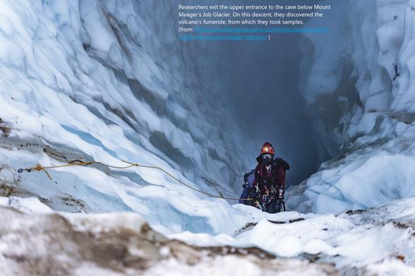
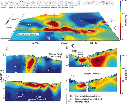
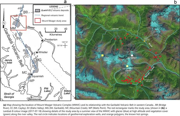
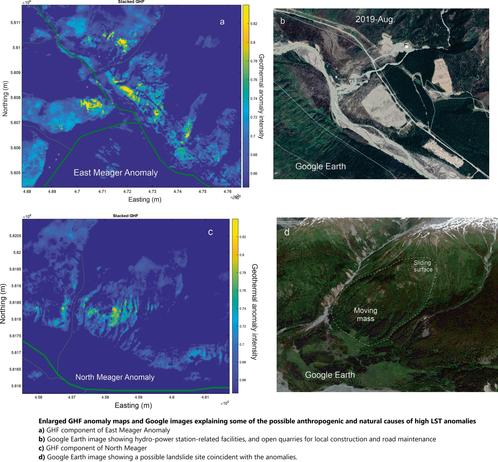
Identification Of Geothermal Anomalies From Landsat Derived Land Surface Temperature, Mount Meager Volcanic Complex, British Columbia, Canada
--
https://doi.org/10.1016/j.rse.2025.114649 <-- shared paper
--
“Highlights:
• A novel method for detecting geothermal components from solar energy dominated LST.
• Using LST time series to eliminate temporal variant solar energy input.
• Uncertainty in anomaly identification quantified by probability measure.
• Capable of revealing LST anomalies caused by geothermal, anthropogenic and surface processes..."
#GIS #spatial #mapping #britishcolumbia #BC #solar #geothermal #remotesensing #earthobservation #LST #spatialanalysis #spatiotemporal #naturalresources #volcanic #geology #geostatistics #landsurfacetemperature #satellite #geothermalheatflux #GHF #energybalance #calculation #model #MountMeager #Landsat #landsat8 #hotspring #landslide #massmovement #engineeringgeology #spring #seep #anthropogenic #HEP #hydropower #monitoring #risk #hazard
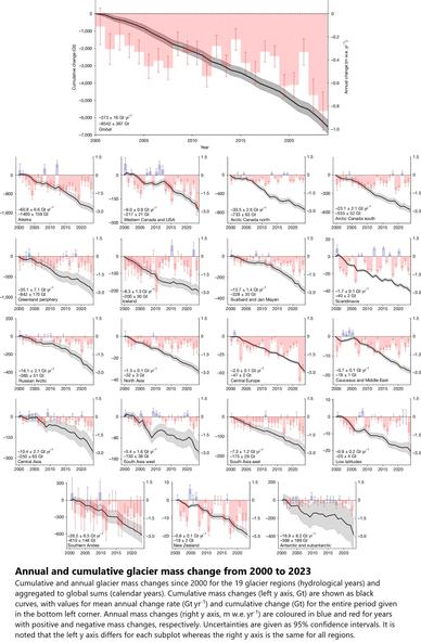
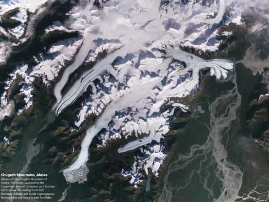
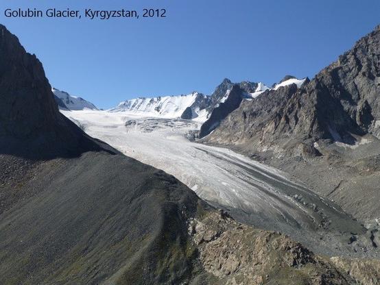
video overview - glacier ice loss over two decades
#GIS #spatial #mapping #GlacierMassBalanceIntercomparison #glacial #glacier #global #cryosphere #regional #frehwater #water #resources #waterresources #watersecurity #sealevel #sealevelrise #SLR #rate #change #spatialanalysis #spatiotemporal #ice #snow #loss #massloss #greenland #antarctic #icesheet #anthropogenic #climatechange #melt #melting #risk #hazard #geohazard #geology #engineeringgeology #marine #terrestrial #ecosystems #watercycle #masschange #insitu #remotesensing #local #observation #model #modeling #projection
Glacier Melt Intensifying Freshwater Loss And Accelerating Sea-Level Rise
--
https://www.esa.int/Applications/Observing_the_Earth/FutureEO/CryoSat/Glacier_melt_intensifying_freshwater_loss_and_accelerating_sea-level_rise <-- shared technical article
--
https://doi.org/10.1038/s41586-024-08545-z <-- shared paper
--
#GIS #spatial #mapping #GlacierMassBalanceIntercomparison #glacial #glacier #global #cryosphere #regional #freshwater #water #resources #waterresources #watersecurity #sealevel #sealevelrise #SLR #rate #change #spatialanalysis #spatiotemporal #ice #snow #loss #massloss #greenland #antarctic #icesheet #anthropogenic #climatechange #melt #melting #risk #hazard #geohazard #geology #engineeringgeology #marine #terrestrial #ecosystems #watercycle #masschange #insitu #remotesensing #local #observation #model #modeling #projection
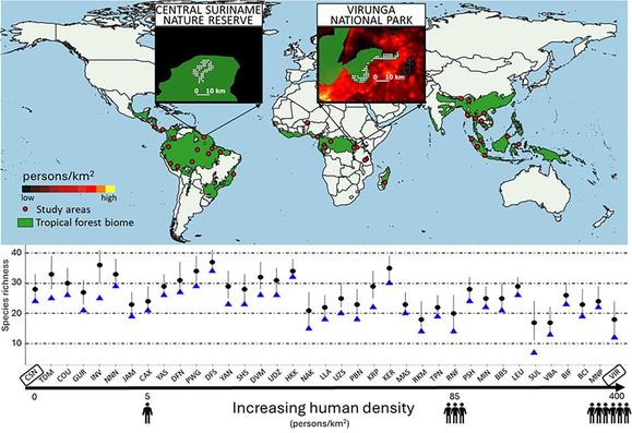
Extinction in tropical forests. This study uses a standardized pan-tropical dataset of 239 mammal species from 37 forests in 3 continents to reveal selective #extinction occurring within #TropicalForests triggered by #anthropogenic pressure in the broader landscape #plosbiology https://plos.io/4jVaeyZ
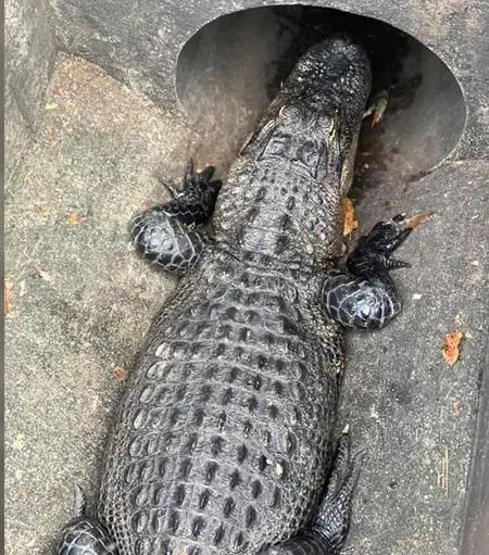
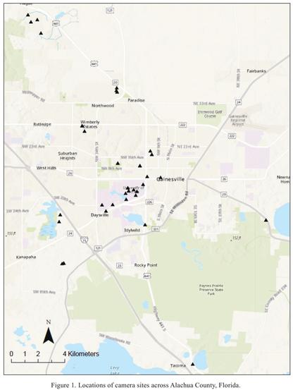
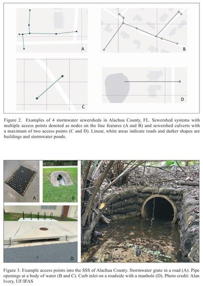
Vertebrate Diversity In Stormwater Sewer Systems Of Alachua County, Florida
--
https://www.eaglehill.us/URNAonline2/access-pages/075-Ivory-accesspage.shtml <-- shared paper
--
[not NYC, but Florida, a fascinating Friday afternoon read for me…]
--
#urbanization #urbanisation #animal #Vertebrate #Diversity #StormwaterSewerSystems #AlachuaCounty #Florida #humaninpacts #urbananimals #subterranean #tunnels #monitoring #cameratraps #anthropogenic #mapping #spatial #spatialanalysis #amphibians #reptiles #birds #mammals #raccoons #alligator #urban #urbanplanning
Levels of microplastics in human brains may be rapidly rising, study suggests
"The exponential rise in microplastic pollution over the past 50 years may be reflected in increasing contamination in human brains, according to a new study."
"The human body is widely contaminated by microplastics. They have also been found in blood, semen, breast milk, placentas and bone marrow. The impact on human health is largely unknown, but they have been linked to strokes and heart attacks".
>>
https://www.theguardian.com/environment/2025/feb/03/levels-of-microplastics-in-human-brains-may-be-rapidly-rising-study-suggests
#plastics #anthropogenic #microplastics #nanoplastic #contamination #MNP #polyethylene #PolymerBasedParticulates #body #OneHealth #pollution
https://www.pdx.edu/research/news/microplastics-widespread-seafood-oregonians-eat-psu-study-finds
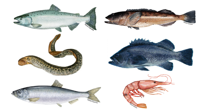
“We found that the smaller organisms that we sampled seem to be ingesting more #anthropogenic, non-nutritious particles,” Granek said. “Shrimp and small fish, like herring, are eating smaller food items like #zooplankton…and these anthropogenic particles may resemble zooplankton and thus be taken up for animals that feed on zooplankton.”
Declining body size is a widely anticipated response to #anthropogenic #ClimateChange, but how general is it? @lbuckley &co use a >50-year study of montane #grasshoppers to show that size shifts depend on both elevation & species’ seasonal timing #plosbiology https://plos.io/3CEBrF6
Oceanic Evasion Fuels Arctic Summertime Rebound Of Atmospheric Mercury And Drives Transport To Arctic Terrestrial Ecosystems
--
https://doi.org/10.1038/s41467-025-56300-3 <-- shared paper
--
#GIS #spatial #mapping #mercury #Hg #contamination #summerrebound #arctic #summertime #atmospheric #transport #contaminate #terrestrial #ecosystems #Hg0 #model #modeling #framework #spatialanalysis #spatiotemporal #concentrations #seaice #atmosphere #river #riverine #GDAS #GEOS #GEOSChem #MERRA2 #GTMM #global #NDVI #remotesensing #cycling #marine #ocean #water #hydrology #seawater #icemelt #anthropogenic #coast #coastal #tundra #permafrost #climatechange #evasion #vegetation #uptake #mitigation
#Microplastics contaminate popular #seafood, study shows
1,806 #anthropogenic #particles were found in 180 of 182 individuals with #fibers being most abundant, followed by #films and #fragments.
https://www.nationofchange.org/2025/01/24/microplastics-contaminate-popular-seafood-study-shows/
Human use of fire has produced an era of uncontrolled burning: Welcome to the #Pyrocene
by Stephen Pyne, The Conversation, January 22, 2025
"#LosAngeles is burning, but it isn't alone. In recent years, fires have blasted through cities in #Colorado, the southern #Appalachians and the island of #Maui, along with #Canada, #Australia, #Portugal and #Greece. What wasn't burned was smoked in.
"Is this another case of a future not only dire but strange, without a narrative to join past to present or an analog for what is to come?
"I'm a historian of fire, and my reply is that we have both a narrative and an analog. The narrative is the unbroken saga of humanity and fire, a companionship that extends through all our existence as a species. The analog is that humanity's fire practices have become so vast, especially in recent centuries, that we are creating the fire equivalent of an ice age."
[...]
Welcome to the Pyrocene
"Widen the aperture a bit, and we can envision Earth entering a fire age comparable to the ice ages of the Pleistocene, complete with the pyric equivalent of ice sheets, pluvial lakes, periglacial outwash plains, mass extinctions and sea-level changes. It's an epoch in which fire is both prime mover and principal expression.
"Humanity's firepower underpins the #Anthropocene, which is the outcome not just of #anthropogenic meddling but of a particular kind of meddling, made possible by humans' species monopoly over fire. Even climate history has become a subset of fire history.
"Fires in living landscapes, fires burning lithic landscapes—the interaction of these two realms of fire has not been much studied. It's been enough of a stretch to fully include human fire practices within traditional ecology. Yet humans—the keystone species for fire on Earth—are merging the two arenas of earthly burning with a give and take that is reshaping the planet in what resembles a slow-motion #Ragnarok.
"Add up all the effects, direct and indirect: the ice driven off by fire, the areas burning, the biogeographical #migrations as biotas move to accommodate changed conditions, the collateral impacts with damaged #watersheds and #airsheds, the unraveling of #ecosystems, the pervasive power of #ClimateChange, #RisingSeaLevels, a #MassExtinction, the disruption of human life and habitats. The result is a #pyrogeography that looks eerily like an ice age for fire. You have a maturing Pyrocene.
"If you doubt it, just ask California."
Full article (it's a good read):
https://phys.org/news/2025-01-human-era-uncontrolled-pyrocene.html
#Wildfires #UncontrolledFires #HistoryOfFire #PyroceneEra #ControlledBurning #ClimateCrisis
#WrongPlaceWrongTime - it's a recurring theme, ain't it!
#Anthropogenic #MassExtinction
#ANTHROPOGENICMASSEXTINCTION
www.bbc.co.uk/programmes/a...
BBC One - Asia - Finding hope:...
Striking Satellite Images Reveal Antarctica Is 10 Times Greener Than 35 Years Ago
--
https://www.sciencealert.com/striking-satellite-images-reveal-antarctica-is-10-times-greener-than-35-years-ago <-- shared technical article
--
https://doi.org/10.1038/s41561-024-01564-5 <-- shared paper
--
#GIS #spatial #mapping #remotesensing #landsat #change #Antarctic #AntarcticPeninsula #spatialanalysis #spatiotemporal #climatechange #greening #vegetation #change #warming #satellite #browning #cryosphere #anthropogenic #warming #moss #terrestrial #ecosystems #GoogleEarthEngine #NDVI #TCG #icefree #model #modeling
