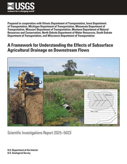
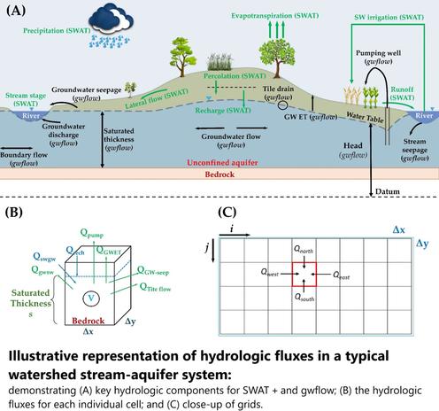
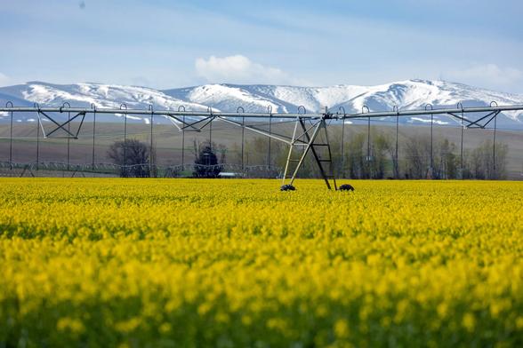
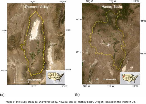
A Framework For Understanding The Effects Of Subsurface Agricultural Drainage On Downstream Flows
--
https://doi.org/10.3133/sir20255023 <-- shared USGS publication
--
#water #hydrology #mapping #framework #model #modeling #fedscience #streamflow #subsurface #soil #drainage #agriculture #farming #landuse #landcover #GIS #spatial #tiledrainage #drains #flow #waterresources #runoff #peakflow #evapotranspiration #precipitation #USA
@USGS
#evapotranspiration
Earth's Storage Of Water In Soil, Lakes And Rivers Is Dwindling - And It's Especially Bad For Farming
--
https://phys.org/news/2025-03-earth-storage-soil-lakes-rivers.html <-- shared technical article
--
https://doi.org/10.1126/science.adq6529 <-- shared paper
--
#water #hydrology #waterresources #global #management #watersecurity #soil #lake #river #snow #groundwater #agriculture #sealevelerise #SLR #climatechange #farming #overuse #waste #moisture #soilmoisture #ecology #ecosystems #storage #model #modeling #spatialanalysis #spatiotemporal #rainfall #drought #consistency #wateruse #crop #plant #vegetation #irrigation #foodsecurity #evapotranspiration #ET #surfacewater #flux #GIS #spatial #mapping #remotesensing #earthobservation #waterstorage #depletion
FARMing With Data - OpenET Launches New Tool For Farmers and Ranchers
--
https://www.nasa.gov/centers-and-facilities/ames/ames-science/farming-with-data-openet-launches-new-tool-for-farmers-and-ranchers/ <-- shared NASA article
--
https://etdata.org/ <-- shared OpenET home page
--
#GIS #spatial #mapping #OpenET #FARMing #spatialdata #spatialanalysis #spatiotemporal #farmers #agriculture #water #hydrology #NASA #USGS #waterresources #ET #evaporation #transpiration #efficiency #weather #climate #evapotranspiration #model #modeling #planning #conservation #sustainability #remotesensing #earthobservation #management #satellite #watermanagement
@USGS @nasa
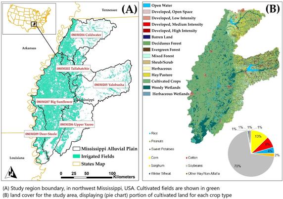
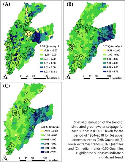
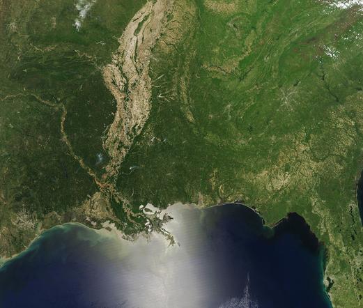
Estimation Of Groundwater Storage Loss Using Surface–Subsurface Hydrologic Modeling In An Irrigated Agricultural Region
--
https://doi.org/10.1038/s41598-025-92987-6 <-- shared paper
--
#GIS #spatial #mapping #hydrology #water #groundwater #model #modeling #estimation #waterresources #watersecurity #irrigated #agriculture #mississippi #alluvialplain #alluvial #aquifer #pump #pumping #mining #SWAT #changes #spatialanalysis #spatiotemporal #surface #subsurface #evapotranspiration #recharge #discharge #massbalance #management
OpenET Project – Estimating The Volume Of Evapotranspiration From Remote Sensing Weather & Other Data Sources
--
https://etdata.org/ <-- link to the project / data resources
--
[sharing of this post does not constitute an endorsement of this product or company]
#GIS #spatial #mapping #remotesensing #OpenET #evapotranspiration #weather #waterresources #watersecurity #watermanagement #water #hydrology #USWest #US #USA #webmaps #EarthEngine #spatialdata #API #ET #farming #agriculture #satellite #DataExplorer #sustainability #irrigation #landsat #waterbudgets #people #ecosystems #environment #groundwater #consumption #planning #budgeting #model #modeling
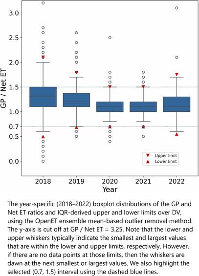
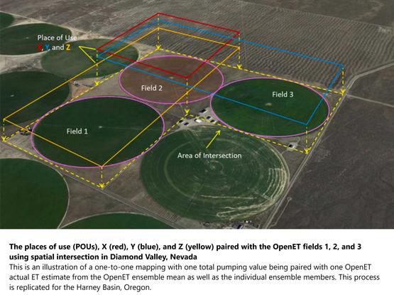
Groundwater Use Can Be Accurately Monitored With Satellites Using Remote Sensing Platform
--
https://phys.org/news/2024-09-groundwater-accurately-satellites-remote-platform.html <-- shared technical article
--
https://doi.org/10.1016/j.agwat.2024.109000 <-- shared paper
--
#GIS #spatial #mapping #groundwater #water #hydrology #remotesensing #satellite #drought #watermanagement #waterresources #watersecurity #monitoring #OpenET #evapotranspiration #model #modeling #farming #agriculture #irrigation #foodsecurity #crop #cropland #consumption #landsat #metered #efficiency #sustainability #USA
What the heck is “#CornSweat” and is it making the Midwest more dangerous?
It’s pretty much just as gross as it sounds.
"In one 2020 study, researchers from the Harvard-Smithsonian Center for Astrophysics analyzed a past summer heat wave in the Midwest and found that cropland — most of which comprised corn in this part of the country — can increase moisture in the air above it by up to 40 percent."
by Benji Jones
Aug 29, 2024
"Ah, yes, late August in the Midwest: a time for popsicles by the lake, a trip to the county fair, and, of course, extreme humidity made more miserable by … corn sweat.
"Corn sweat. It’s a thing! And people are talking about it.
The term refers to the moisture released by fields of corn during hot and sunny weather. Like all other plants, corn transpires — meaning, it sucks up water from the ground and expels it into the air as a way to stay cool and distribute nutrients. Moisture also enters the air when water in the soil evaporates. Together with transpiration, this process is called #evapotranspiration.
"So, where you find loads of plants packed tightly into one place, whether the Amazon rainforest or #Iowa, humidity can skyrocket during hot and especially sunny periods, making the air feel oppressive.
"That’s what happened this week: A late-summer #heatwave brought record and near-record temperatures to parts of the Midwest where there also happen to be vast fields of corn. With plenty of sunlight and temperatures in the high 90s, it was enough to make corn sweat, producing extremely uncomfortable weather.
"It’s not that corn sweats more than other plants — an acre releases less moisture on average than, say, a large oak tree — but the Midwest has a lot of corn in late August. In Iowa, for example, more than two-thirds of the area is farmland, and corn is the top crop (followed by #soybeans, which, by the way, also sweat)."
[...]
"Again, it’s not just crops across the #Midwest that release moisture, increase humidity, and make summers feel disgusting (I know firsthand; I grew up in Iowa). The millions of acres of #prairie that industrial farmland replaced — mostly to feed livestock and make ethanol — would have also produced loads of moisture, Basso said.
"But there are some key differences between native #ecosystems and #IndustrialFarmland, he added. '#NativePrairies are diverse ecosystems with a variety of plant species, each with different root depths and water needs, helping to create a balanced moisture cycle,' he told me. 'In contrast, corn and #soy #monocultures are uniform and can draw water from the soil more quickly.'"
#CimateChange #IndustrialAgriculture #BigAg #Wetbulb #Fieldworkers #HeatWaves
‘Corn Sweat’ and #ClimateChange Bring Sweltering #Weather to the #Midwest
The #heat is accompanied by #humidity from two sources: moist air that is streaming up from the Gulf of Mexico and a phenomenon that is sometimes called “#cornsweat.” The latter happens when #corn, #soybeans and other crops release moisture as the temperature climbs. This process, known technically as #evapotranspiration, is akin to how humans perspire in the heat.
https://www.scientificamerican.com/article/corn-sweat-and-climate-change-bring-sweltering-weather-to-the-midwest/
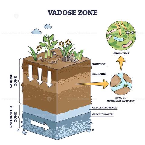
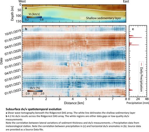
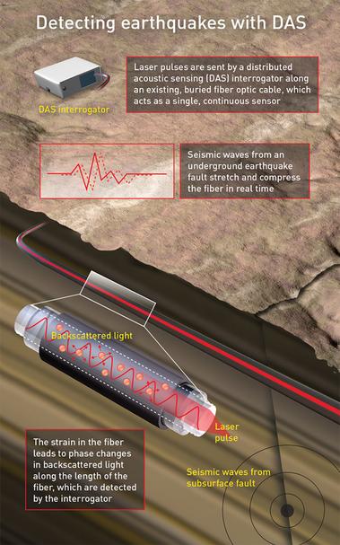
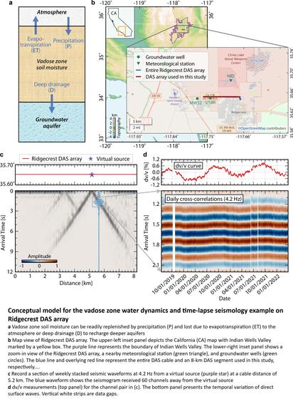
Fiber-Optic Seismic Sensing Of Vadose Zone Soil Moisture Dynamics
--
https://doi.org/10.1038/s41467-024-50690-6 <-- shared paper
--
[broadly, a 'seismic' listening technique could help researchers map water movement, moisture levels in soil, with these researchers at Caltech have figured out a way to use vibrations from passing cars to see how much water sits directly beneath the ground’s surface…]
#GIS #spatial #mapping #remotesensing #array #survey #soil #regolith #seismic #water #hydrology #waterresources #watersecurity #subsurface #vadose #vadosezone #soilmoisture #moisture #weather #precipitation #rainfall #surfacewater #groundwater #ecology #agriculture #ecosystems #spatiotemporal #model #modeling #spatialanalysis #fiberoptics #fibreoptics #evapotranspiration #insitu #climatechange #drought #extremeweather #watermanagement #semiarid #geophysics
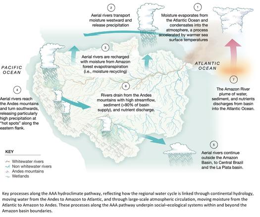
There's A Hidden Water Cycle In The Amazon We Barely Know Anything About
--
https://www.sciencealert.com/theres-a-hidden-water-cycle-in-the-amazon-we-barely-know-anything-about <-- shared technical article
--
https://www.pnas.org/doi/10.1073/pnas.2306229121 <-- shared paper / review
--
#GIS #spatial #mapping #water #hydrology #Amazon #AmazonRainForest #rainforest #brazil #peru #colombia #model #modeling #watercycle #river #stream #streamflow #freshwater #watersecurity #environment #habitat #biodiversity #forest #wetlands #hydroclimate #AAA #pathway #rainfall # #precipitation #evapotranspiration #biome #multifactor #spatialanalysis #spatiotemporal #terrestrial #aquatic #sediment #nutrients #climatechange #basin #amazonbasin #temperature #climatology #waterbalance #socialecology
Increased Carbon Assimilation And Efficient Water Usage May Not Compensate For Carbon Loss In European Forests
--
https://doi.org/10.1038/s43247-022-00535-1 <-- shared paper
--
#GIS #spatial #mapping #model #modeling #spatialanalysis #spatiotemporal #europe #european #vegetation #trees #tree #forest #forestry #biomass #warming #climatechange #ecosystem #water #evapotranspiration #primaryproduction #MODIS #satellite #wateruse #productivity #change #phenology #remotesensing #earthobservation
New Water Accounting Reveals Why The Colorado River No Longer Reaches The Sea
--
https://doi.org/10.1038/s43247-024-01291-0 <-- shared paper
--
#GIS #spatial #mapping #ColoradoRiver #ColoradoRiverBasin #CRB #USA #waterresources #USWest #irrigation #crops #feed #grass #hay #alfalfa #SaudiArabia #watersecurity #wateruse #water #hydrology #waterrights #overuse #magicwater #extraction #rationing #cropland #watercrisis #accounting #volumetric #model #river #watersupply #modeling #riparian #wetland #ET #evapotranspiration #waterbudget #regional #municipal #agriculture #commercial #industrial #cattle #cattlefeed #spatialanalysis #spatiotemporal
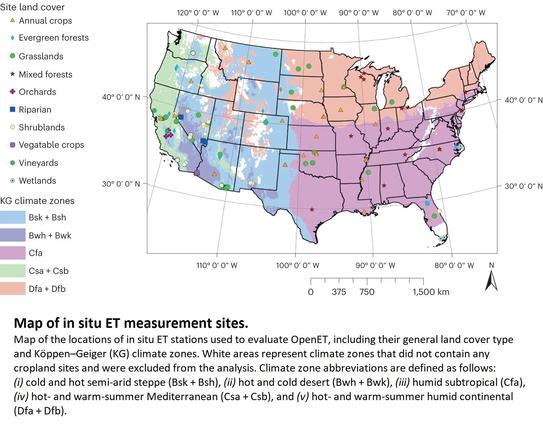
A New, Rigorous Assessment Of Remote Sensing Tool's Accuracy For Supporting Satellite-Based Water Management [NASA's OpenET]
--
https://phys.org/news/2024-01-rigorous-remote-tool-accuracy-satellite.html <-- shared technical article
--
https://doi.org/10.1038/s44221-023-00181-7 <-- shared paper
--
https://www.nasa.gov/image-article/openet-satellite-based-water-data-resource/ <-- NASA OpenET satellite-based water data home page
--
https://youtu.be/uAapAAInDpQ?si=njJfqvrtZ1MWR3CQ <-- NASA OpenET overview video
--
#GIS #spatial #mapping #water #waterresources #hydrology #watersecurity #OpenET #remotesensing #model #modeling #satellite #watermanagement #statistics #geostatistics #opendata #arid #sustainable #landsat #evapotranspiration #ET #corrleation #watermanagement #soil #plant #crops #cropland #agriculture #farming #wheat #corn #soy #rice #waterconservation #watersustainability #watersupply #NASA
@nasa
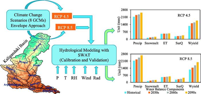
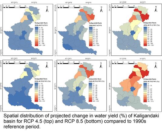
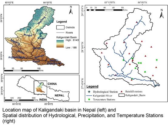
Climate Change Impact Assessment On The Hydrological Regime Of The Kaligandaki Basin, Nepal
--
https://doi.org/10.1016/j.scitotenv.2017.12.332 <-- shared paper
--
“HIGHLIGHTS
• The rise in temperature and increase in precipitation is projected in future in Kaligandaki River basin.
• The water availability in the basin is not likely to decrease during this century.
• The change in water balance in the upper sub-basins of Kaligandaki River is higher.
• The output from this research could be beneficial for water resources management..."
#GIS #spatial #mapping #Nepal #Kaligandaki #riverbasin #basin #river #hydrology #model #modeling #numericmodeling #climatechange #temperature #precipitation #ET ##waterresources #water #watersecurity #waterbalance #impactassessment #humanimpacts #freshwater #HinduKush #himalayas #SWAT #prediction #projection #cimip5 #gcm #waterbalance #snowmelt #evapotranspiration #spatialanalysis #spatiotemporal
Deforestation has big impact on regional temperatures
"...Deforestation causes warming at distances up to 60 miles away. The greater the forest clearance, the higher the temperature. This is in addition to the wider climate impact of global heating."
“We show that regional forest loss increases warming by more than a factor of four with serious consequences for the remaining Amazon forest and the people living there.”
“More and more, we are demonstrating the big benefits the forests bring to surrounding regions. For farmers, they bring cooler air and more rainfall. Until now, studies on the impact of forest clearance on heat have concentrated on local effects with a clear correlation between loss of tree cover and higher temperatures in the area where the trees were cut down. The new research went further by looking at whether there is also a warming effect over a wider area." >
https://www.theguardian.com/environment/2023/oct/30/deforestation-has-big-impact-on-regional-temperatures-study-of-brazilian-amazon-shows
Amazon deforestation causes strong regional warming
"Tropical deforestation warms the climate with negative impacts on people living nearby." >
https://www.pnas.org/doi/full/10.1073/pnas.2309123120
#drought #Bushfires #risks #NativeForests #evapotranspiration #deforestation #heatwaves #ExtremeHeatwaves #LoggingIndustry #NativeForests #LoggingIndustry #StopLogging #SaveTuckersNob
#eoChat #RemoteSensing determination of #Evapotranspiration
**Algorithms, strengths, weaknesses, uncertainty and best fit-for-purpose released by #FAO -> **https://doi.org/10.4060/cc8150en
6/
A 2021 study [3] mentioned a similar #CascadeEffect, previously studied in 2018 [4]:
"A possible reason for this 20 % decrease in #precipitation in both western-central regions, despite experiencing less #deforestation compared to the eastern sites, is the cascade effect [4].
That is, deforestation in eastern #Amazonia may be reducing #evapotranspiration, which in turn may be reducing the recycling of water vapour that is transported to the western Amazonia" [3]
4/
The authors [1] conclude
- "After the #dieback of the #rainforest, the soil moisture approaches an #alternative #equilibrium consistent with the reduced #precipitation and #evapotranspiration of the #savanna vegetation"
- "At the #CriticalPoint, the atmospheric moisture content does not suffice anymore to maintain precipitation and, thus, latent heating rates that could switch the system back into the annual wet season, resulting in a permanent dry season state"
3/
Next proposed [1] steps:
- "The heating gradient between the Atlantic Ocean and the continent weakens and impedes the annual transition into the wet season"
- A "shortened wet season and the decreasing #rainfall rates result in lower soil moisture"
- But #evapotranspiration rates "stay at a high level and further deplete the soil during the dry season" leading to an "all-year-round decrease of the soil moisture and an increasing [soil moisture deficit] before the dieback of the rainforest"
I still prefer #Graupel & #Hadoop for #WeatherBingo words but today you can add #WetBulbGlobeTemperature and #CornSweat (or #evapotranspiration) to your card. #Minnesota #Minnesauna #mnwx #HeatWave
