#forecasted

2025-11-26

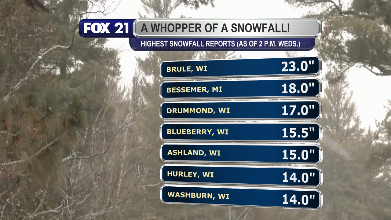
As #forecasted, the South Shore and Upper Peninsula regions have seen the most #snowfall in the #Northland, with more snow falling the rest of today and tonight.

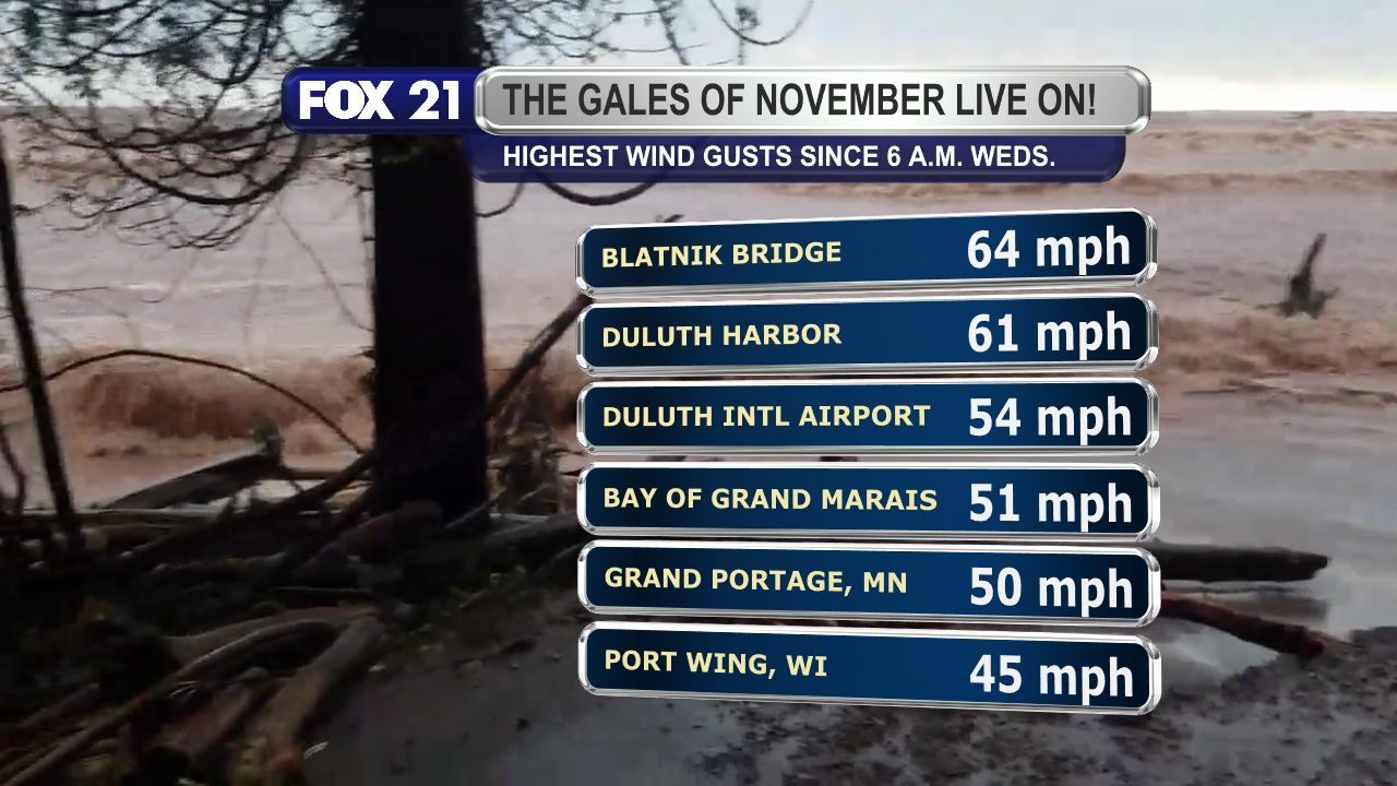
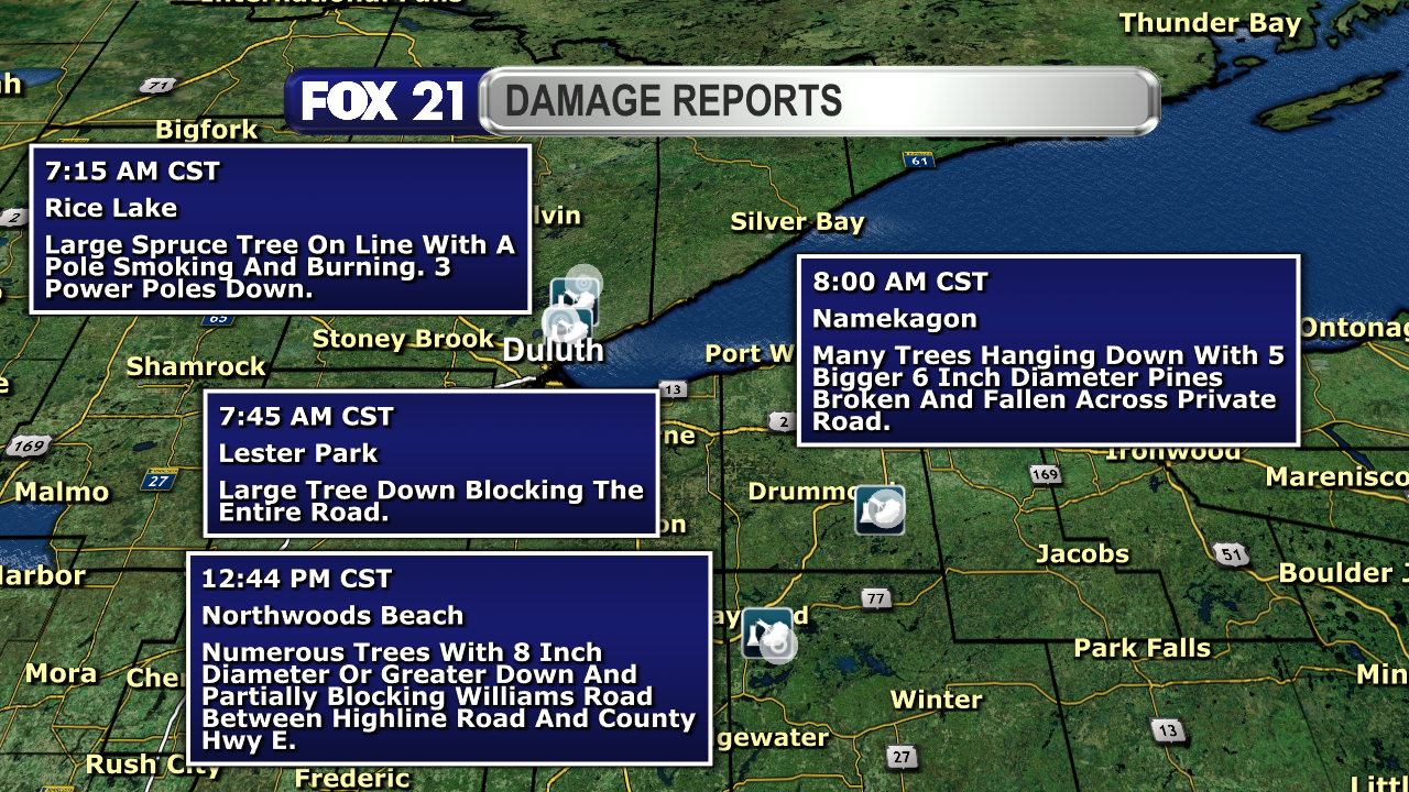
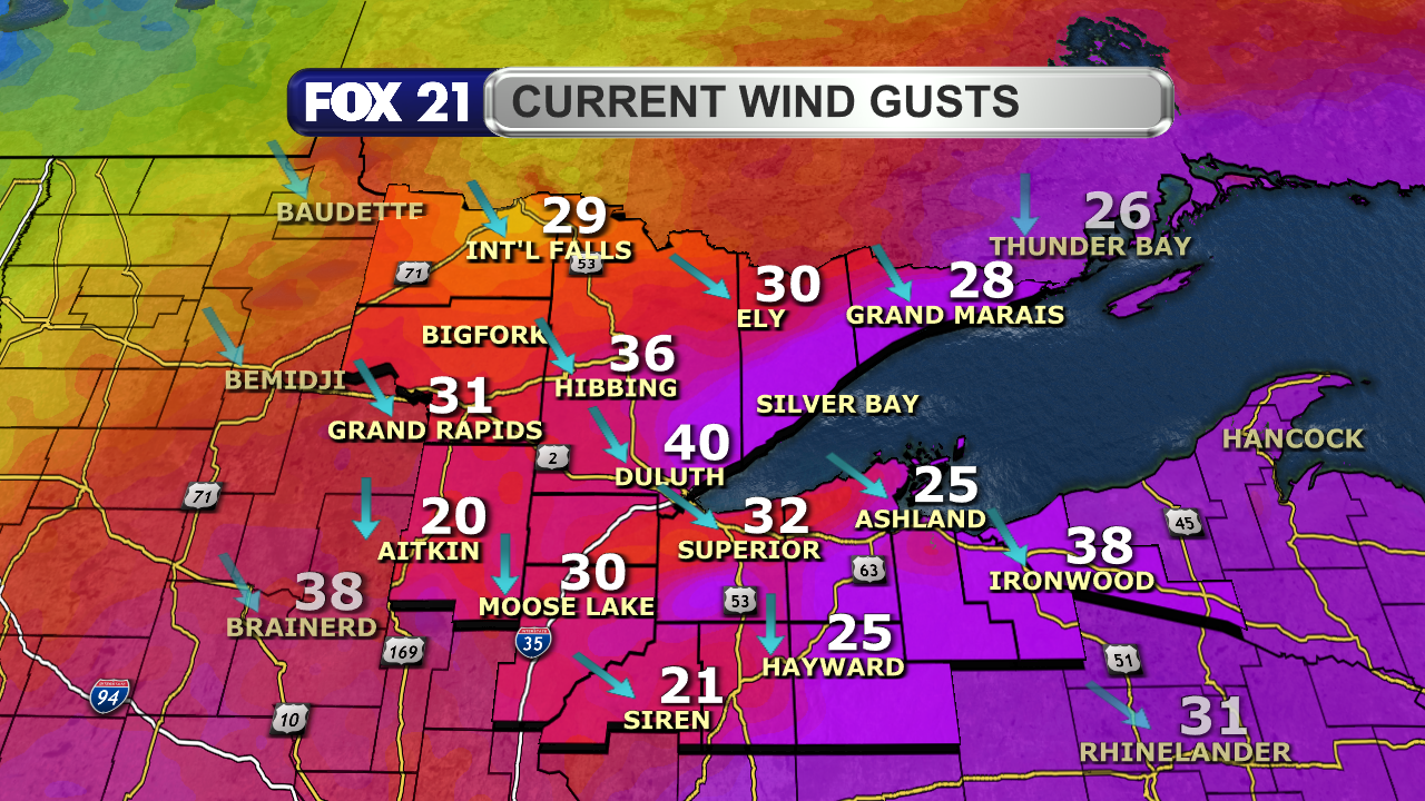
#Winds have been #strong, with #gusts of 40+ mph last night and Wednesday morning. They will slowly calm through Thursday.

#wxtooter #weather #wx #WIwx #UPwx #MNwx

As of 2 p.m. on Wednesday, November 26, 2025, the highest snowfall totals in the Northland include 23-inches in Brule, Wisconsin, 18-inches in Bessemer, Michigan, 17-inches in Drummond, Wisconsin, 15.5-inches in Blueberry, Wisconsin, 15-inches in Ashland, Wisconsin, and 14-inches in both Hurley, Wisconsin and Washburn, Wisconsin.  These areas are continuing to see snowfall through the rest of Wednesday and Wednesday night.Wind gusts have been strong since Tuesday night in the Northland.  The highest recorded gusts since 6 a.m. Wednesday, November 26, 2025, include 64-mph on the Blatnik Bridge in the Twin Ports, 61-mph at Duluth Harbor, 54-mph at Duluth International Airport, 51-mph at the Bay of Grand Marais, 50-mph in Grand Portage, Minnesota, and 45-mph at Port Wing, Wisconsin.The combination of wet snowfall and strong wind gusts have led to a number of reports of downed trees across the Northland.  Some of those reports are from the Duluth area, as well as Namekagon and Northwoods Beach in Wisconsin.  There was also a report of a downed tree that struck a 69-year-old man who was snow blowing on his property northwest of Two Harbors.  He died from his injuries.Wind gusts reported across the Northland just before 2 p.m. on November 26, 2025, range from 20 to 40 mph.  The strongest gusts were along the Lake Superior shoreline regions, as well as interior northwest Wisconsin and the Upper Peninsula.  The wind direction has shifted to the northwest and north/northwest.
2025-04-03

FINAL SNOWFALL TOTALS:

The third major #storm system to impact the #Northland this week is over.

As #forecasted, the North Shore saw the highest #snowfall totals over the past few days with 12 to 15 inches recorded.

The rest of the #Minnesota side north of Highway 2 saw the next highest totals of 6 to 10 inches.

Amounts were below 6 inches elsewhere thanks to the storm's #dryslot limiting precipitation.

#wxtooter #weather #wx #MNwx #WIwx #UPwx

The highest snowfall totals recorded from a storm system that passed through the Northland April 1 through April 3, 2025, were along the North Shore region.  They were 15.2-inches in Hovland, Minnesota, 14.4-inches in Wolf Ridge, Minnesota, 13.1-inches in Tofte, Minnesota, 12.2-inches in Grand Marais, Minnesota, 11.8-inches in Silver Bay, Minnesota, 11.7-inches near Two Harbors, Minnesota, and 9.7-inches in the Duluth, Minnesota area.Other snowfall totals recorded in the Northland away from the North Shore between April 1, 2025 and April 3, 2025, include 9-inches in Celina, Minnesota, 8.7-inches in Northome, Minnesota, 8.4-inches in Orr, Minnesota, 7-inches in Wrenshall, Minnesota, 6-inches in Washburn, Wisconsin, and 5-inches in Poplar, Wisconsin.
2025-03-05

4 P.M. #RADAR UPDATE & SNOW TOTALS:

The last of the #snow #showers from a large #storm system are moving out of the #Northland to the east.

As #forecasted, northwest #Wisconsin and the #UpperPeninsula saw the highest #snowfall totals. I expect some of them to increase as new measurements are made.

#wxtooter #weather #wx #WIwx #UPwx #MNwx

The satellite and radar over the Northland at 4 p.m. on Wednesday, March 5, 2025, shows several lines of snow showers just off the North Shore region, from Ashland County extending into Lake Superior, and over parts of the Upper Peninsula.  They are moving to the east.  Clearing skies are occurring west of Highway 53.As of 3 p.m. on Wednesday, March 5, 2025, the highest snowfall totals reported to the National Weather Service across the Northland include 10.3-inches in Ashland, Wisconsin, 10-inches in Washburn, Wisconsin and Cedar, Wisconsin, 9-inches in Gile, Wisconsin, 8.8-inches in Mellen, Wisconsin and Sarona, Wisconsin, and 8.6-inches in Maple, Wisconsin.Other snowfall totals reported to the National Weather Service across the Northland as of 3 p.m. Wednesday (Central Standard Time) include 7.2-inches in Shell Lake, Wisconsin, 7.1-inches in Ironwood, Michigan, 7-inches in Webster, Wisconsin and Herbster, Wisconsin, 6.5-inches in Hayward, Wisconsin, and 6.3-inches in Bayfield, Wisconsin.
2024-12-19

Happy #Thursday afternoon from the #Northland!

The #clipper system continues to pass through the region with a weaker punch that what was #forecasted Wednesday. The perils of a high-ratio #snowfall event...

Still, expect #slick road conditions through tonight as it remain #cool for everyone.

#wxtooter #weather #wx #MNwx #WIwx #UPwx

The satellite and radar over the Northland at 1:30 p.m. on Thursday, December 19, 2024, shows show showers over the southern two-thirds of the region, excluding the South Shore snowbelt region.  Clouds persist over the entire region.Winter weather alerts in effect across the Northland have been downgraded to a Winter Weather Advisory for Ashland, Bayfield, Burnett, Carlton, Douglas, Gogebic, Iron, southern Lake, Ontonagon, Sawyer, southern St. Louis, and Washburn counties.  They will expire no later than 9 a.m. Friday, December 20, 2024.Temperatures in the Northland just after 1 p.m. on December 19, 2024, range from 9 to 22 degrees.Wind speeds in the Northland just after 1 p.m. on December 19, 2024, range from calm to 12 mph.  Wind directions are primarily form the east and northeast.
2024-11-19

REACP OF #WET & #WINDY #STORM:

I like it when the past 24 hours of #weather have played out as #forecasted in the #Northland.

The #NorthShore saw the highest #rainfall totals, but everyone got at least around 0.50".

#Winds were also #gusty, with the highest totals near #LakeSuperior.

#wxtooter #wx #MNwx #WIwx #UPwx

The highest rainfall totals recorded in the Northland since Monday afternoon were along the North Shore.  They include Finland at 2.96-inches, Beaver Bay at 2.60-inches, Two Harbors at 2.30-inches, Grand Marais at 2.15-inches, Grand Portage at 2.13-inches, and Silver Bay at 2.05-inches.Other rainfall totals recorded in the Northland since Monday afternoon include Hovland, Minnesota at 2.03-inches, the Duluth area at 1.93-inches, Lutsen, Minnesota at 1.84-inches, Tofte, Minnesota at 1.75-inches, Hermantown, Minnesota at 1.52-inches, and Pine City, Minnesota at 1.46-inches.The highest wind gusts recorded across the Northland since Monday afternoon were 61 mph at the Blatnik Bridge in the Twin Ports, 52 mph at both Duluth International Airport and the Bay of Grand Marais, 49 mph at Thompson Hill, 48 mph at Sky Harbor, and 46 mph at Devils Island, Wisconsin.Since midnight on Tuesday, November 19, 2024, airports across the Northland recorded their highest wind gusts ranging from 26 to 46 mph.  The highest were along the North Shore, Twin Ports, and Arrowhead regions.
2024-01-03

Happy #Wednesday from the #Northland!

#Clouds have stuck around the region a bit longer than what I #forecasted Tuesday, but #clearing skies will be arriving later today.

It is a #cooler #weather day with #temperatures closer to #seasonal. Expect a #chilly night with #lows in the single digits for most of us.

#wxtooter #wx #MNwx #WIwx #UPwx

The satellite and radar over the Northland at 1:25 p.m. on Wednesday, January 3, 2024 shows clouds and some light snow showers passing through the region.  Some clearing skies are starting to filter into the area near the Canadian border and the Arrowhead.Temperatures in the Northland just before 1:30 p.m. on Wednesday, January 3, 2024 range from 15 to 28 degrees.  They are coldest near the Canadian border, warming as one heads south across the region.Compared to 1 p.m. on Tuesday, January 2, 2024, temperatures in the Northland today are running 5 to 15-degrees colder.Wind speeds in the Northland just before 1:30 p.m. on Wednesday, January 3, 2024 range from 5 to 13 mph.  Wind direction from the north and northwest.
Nick Byrd, Ph.D.ByrdNick@nerdculture.de
2023-11-13

How has gender #bias in #hiring changed from 1976 to 2020?

"selection bias in favor of male over female candidates was eliminated and, [for many jobs], slightly reversed ...starting in 2009" across "244 effect sizes from 85 field #audits and 361,645 ...job applications".

#Academics (including me) #forecasted that trajectory better than U.S. laypeople on average, but each group's average forecasts overestimated anti-female/pro-male bias by ≥ 2x?

doi.org/10.1016/j.obhdp.2023.1

#perception #reality

Description of exclusion criteria and geographic location of audit studies.The negative and slightly reversed trend in gender bias in hiring.Table 2. Results of hypothesis tests using multi-level meta-analysis.Figure 4, breaking down change in gender bias over time by gender-type of the job and Figure 7 showing the observed trend compared to forecasts of from academics and U.S. laypersons.

Client Info

Server: https://mastodon.social
Version: 2025.07
Repository: https://github.com/cyevgeniy/lmst