#Wirtual hat’s geschafft und als erster #DeepSlip bezwungen. Es hat nur fast 93 Stunden und 264 Anläufe gebraucht. 👍 Damit ist nach #DeepDip und #DeepDip2 die 3. #Trackmania oneshoot #Towermap durch. Man darf gespannt sein mit was für einem Tower die #Mapper als nächstes die #Driver #SkillTesten
#mapper
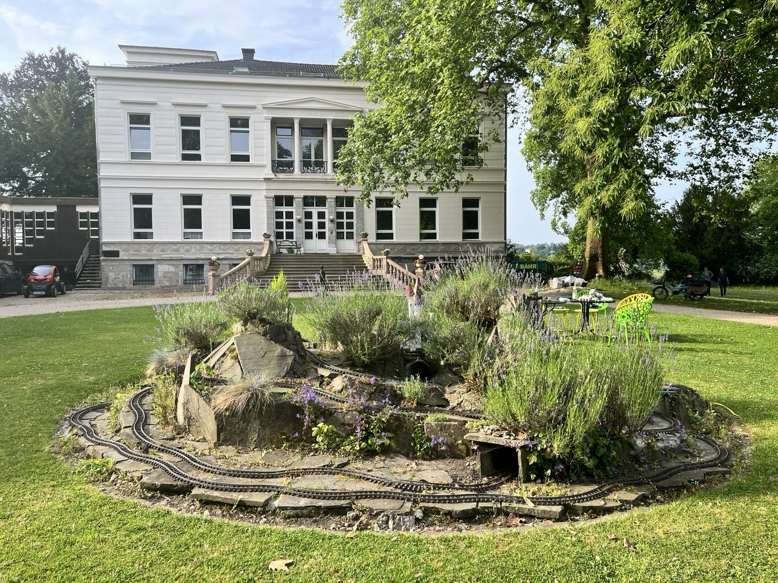
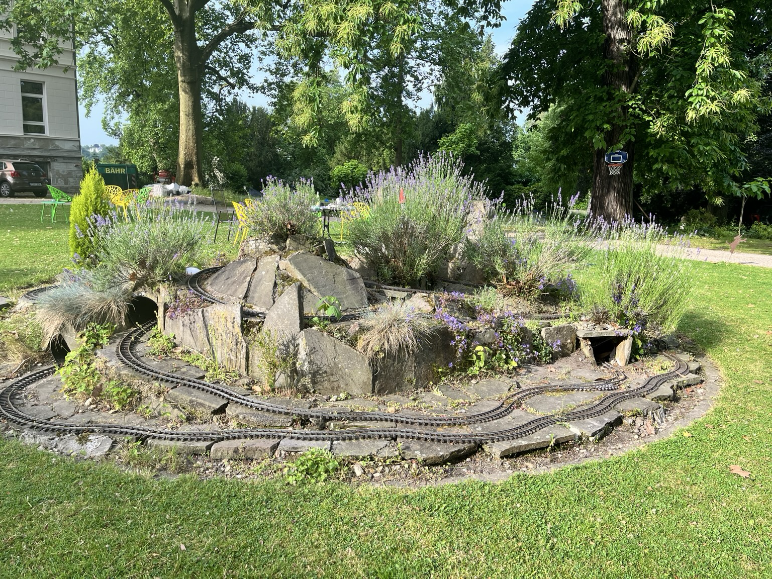
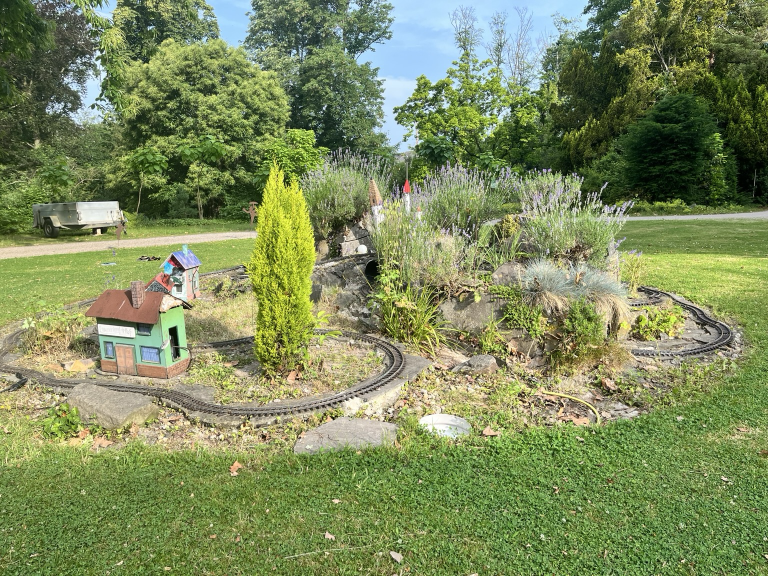
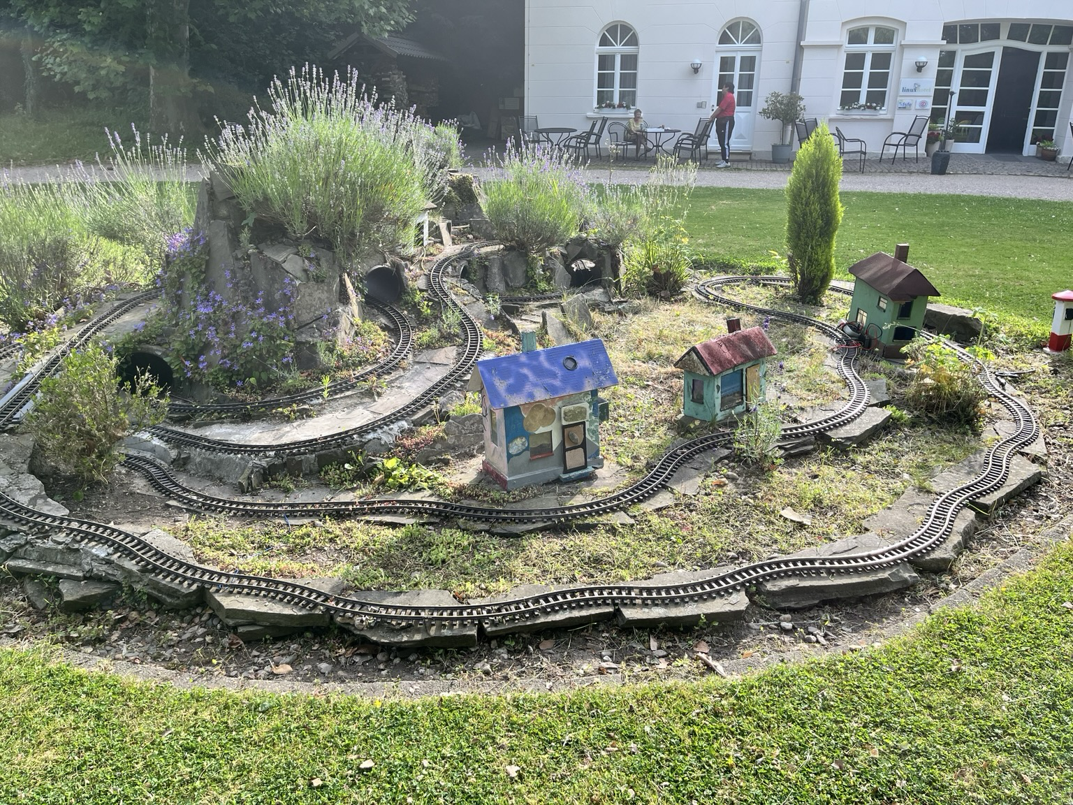
So sieht das #lummerland im @linuxhotel aktuell aus.
#mapper können sie auch noch detaillierter in der #OpenStreetMap erfassen.
For the past 2 weeks or so, I have been fiddling with #OpenLayers for #PixelMap, and finally got to a version where it works sufficiently enough. I will be tinkering more on it in the future, but I am happy with the results so far.
I'm currently trying to integrate #OpenLayers with #PixelMap, and while I spent several hours getting it to work, it finally clicked and I now have control over what I'm doing. It's weird with their documentation, being either false or outdated, I had to look for third party tutorials and forums to make it behave as I would like, and still it was hard.
We're currently assembling a team, and we need your help! Whether you're a #developer, a meticulous #mapper, a talented #graphic #designer, a #sound engineering expert, or just brimming with #creative #ideas, there's a role waiting for you here.
🔗 Join us on our mission to free the #fpsz genre! https://discord.gg/mwSrUTNDuy
#openfpsz #indiedev #gamedev #fps #fpsz #godot #starsiege #tribes
Building a DIY MSX Mega Cartridge https://hackaday.com/2024/09/07/building-a-diy-msx-mega-cartridge/ #Retrocomputing #retrocomputing #cartridge #mapper #msx
Wo bleiben die anderen Urlauber? 😊 Ich erwarte nicht, dass das lange so bleibt.
#Mapper #Momentaufnahme #Letzte7Tage #StreetComplete #OpenStreetMap

President Ferdinand R. Marcos Jr. on strengthening support for teachers and advancing education at #SONA2024 #Mapper
Bagong Pilipinas's Diary | SONA 2024
Bagong Pilipinas's Diary | SONA 2024
Measuring #methane from space only began in 2009 with the launch of the Greenhouse Gases Observing Satellite, or #GOSAT, by Japan’s Aerospace Exploration Agency.
Previously, most of the world’s methane detectors were on the ground in North America.
GOSAT enabled scientists to develop a more geographically diverse understanding of major sources of methane to the atmosphere.
Soon after, the Environmental Defense Fund, which led the development of #MethaneSAT, began campaigning for better data on methane emissions.
Through its own, on-the-ground measurements, the group discovered that the Environmental Protection Agency’s estimates of leaks from U.S. oil and gas operations were totally off.
EDF took this as a call to action. Because methane has such a strong warming effect, but also breaks down after about a decade in the atmosphere, curbing methane emissions can slow warming in the near-term.
“Some call it the low hanging fruit,” Steven Hamburg, the chief scientist at EDF leading the MethaneSAT project, said during a press conference on Friday. “I like to call it the fruit lying on the ground. We can really reduce those emissions and we can do it rapidly and see the benefits.”
But in order to do that, we need a much better picture than what GOSAT or other satellites like it can provide.
In the years since GOSAT launched, the field of methane monitoring has exploded.
Today, there are two broad categories of methane instruments in space.
#Area #flux #mappers, like GOSAT, take global snapshots. They can show where methane concentrations are generally higher, and even identify exceptionally large leaks — so-called “ultra-emitters.” But the vast majority of leaks, big and small, are invisible to these instruments.
Each pixel in a GOSAT image is 10 kilometers wide. Most of the time, there’s no way to zoom into the picture and see which facilities are responsible.
#Point #source #imagers, on the other hand, take much smaller photos that have much finer resolution, with pixel sizes down to just a few meters wide. That means they provide geographically limited data — they have to be programmed to aim their lenses at very specific targets. But within each image is much more actionable data.
But between this extremely wide-angle lens, and the many finely-tuned instruments pointing at specific targets, there’s a gap.
“It might seem like there’s a lot of instruments in space, but we don’t have the kind of coverage that we need yet, believe it or not,” Andrew Thorpe, a research technologist at NASA’s Jet Propulsion Laboratory told me. He has been working with the nonprofit #Carbon #Mapper on a new constellation of point source imagers, the first of which is supposed to launch later this yearhand, take much smaller photos that have much finer resolution, with pixel sizes down to just a few meters wide.
That means they provide geographically limited data — they have to be programmed to aim their lenses at very specific targets. But within each image is much more actionable data.
For example, #GHGSat, a private company based in Canada, operates a constellation of 12 point-source satellites, each one about the size of a microwave oven. Oil and gas companies and government agencies pay GHGSat to help them identify facilities that are leaking.
Jean-Francois Gauthier, the director of business development at GHGSat, told me that each image taken by one of their satellites is 12 kilometers wide, but the resolution for each pixel is 25 meters.
A snapshot of the Permian Basin, a major oil and gas producing region in Texas, might contain hundreds of oil and gas wells, owned by a multitude of companies, but GHGSat can tell them apart and assign responsibility.
“We’ll see five, 10, 15, 20 different sites emitting at the same time and you can differentiate between them,” said Gauthier.
“You can see them very distinctly on the map and be able to say, alright, that’s an unlit flare, and you can tell which company it is, too.”
Similarly, GHGSat can look at a sprawling petrochemical complex and identify the exact tank or pipe that has sprung a leak.
But between this extremely wide-angle lens, and the many finely-tuned instruments pointing at specific targets, there’s a gap. “It might seem like there’s a lot of instruments in space, but we don’t have the kind of coverage that we need yet, believe it or not,” Andrew Thorpe, a research technologist at NASA’s Jet Propulsion Laboratory told me.
He has been working with the nonprofit #Carbon #Mapper on a new constellation of point source imagers, the first of which is supposed to launch later this year
https://heatmap.news/technology/methanesat-edf-satellite-gosat
Хватит маппить все руками, используй Mapster
Привет, Хабр! Меня зовут Георгий, я С#-разработчик в SimbirSoft. Хочу рассказать об опыте использования библиотеки Mapster: как он может упростить разработку, сэкономить силы и частично избавиться от рутины маппинга. Данная статья подойдет и тем, кто только собирается открыть для себя мир автомаппинга, и тем, кто хочет найти для себя альтернативу используемой библиотеки. Для полного понимания, что тут будет происходить желательно обладать базовым пониманием C#, знать о существовании DI и подозревать, что рефлексия не так проста, как кажется. Ну и LINQ с EF.Core, куда же без них (хотя про них достаточно просто когда-то слышать и примерно представлять, зачем они нужны).
@stephenrobles
This is a *solid* list.
I already had:
#Facades
#HomePass
#LegoBuilder
#MacTracker
#Mapper
#Play
Trying:
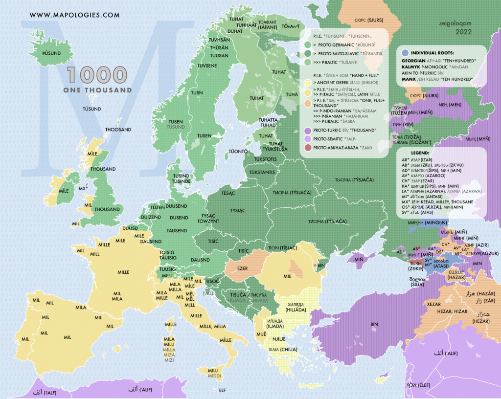
1000 followers on #instagram is a good chance to share the #map of one thousand in different languages and their #etymologies.
Be the one thousand-one: https://www.instagram.com/mapologiess
#thousand #mil #mile #tisiac #bin #tisic #ezer #tausend #tuhat #mapologies #etymlogymap #mapper
Du kannst ja mal OSM mit Hinweis-Layer aufrufen:
https://www.openstreetmap.org/#&layers=N
Scrolle und zoome in die Karte, drücke rechte Maustaste und erstelle einen Hinweis. Alternativ kannst du natürlich hier auch mal die Position posten.
Besser wäre natürlich, wenn du selbst #Mapper für #OSM werden würdest. Unter Android kannst du für den Einstieg gut die App #StreetComplete nutzen.
Finally. I needed a 3rd party extension to do it but I’ve managed to get websites to open directions in #AppleMaps instead of #GoogleMaps.
Edit: the #Mapper extension only works in #Safari so when I use #DuckDuckGo or #Firefox for #iOS, websites still default to Google but it’s a start.
Immer wenn ich bislang mit #StreetComplete auf ungemappte Objekte gestossen bin habe ich entweder #Vespucci gestarted, oder häufiger mit StreetComplete eine #OSMNote mit Foto hinzugefügt. Oft haben dann andere #Mapper diese Notes eingetragen und geschlossen, wobei meistens nicht alle Details erfasst wurden, die auf dem am Note hängenden Foto sichtbar waren. Zudem hatte ich oft noch mehr Details der Umgebung im Kopf.
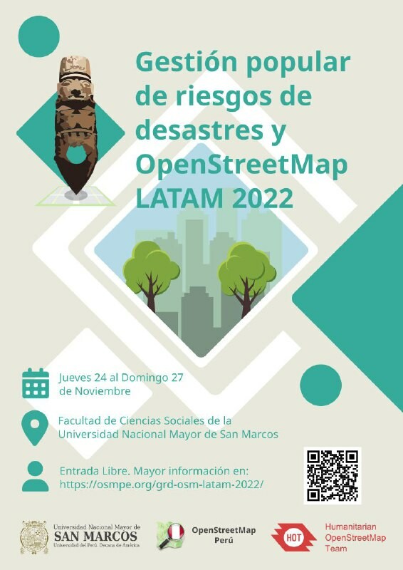
Gestión popular de riesgos de desastres y OpenStreetMap LATAM
24 al 27 de noviembre, UNMSM, Lima, Peru.
Inscríbanse: https://osmpe.org/grd-osm-latam-2022/
.
#openstreetmap #hotosm #openmapping #mapeoabierto #mapping #mapeo #trainings #taller #workshops #mapeople #mapper #mappers #mapeadores #fieldwork #trabajodecampo #socialproject #proyectossociales #drones #gestionderiesgos #riskmanagement #cartography #cartografia
#lima #unmsm
If I'd #ReImaginedTheWeb today
I'd add a #mapper, #indexer and #search to the browser
The mapper tracks of how you reached pages while browsing and can show you this as an interactive map.
The indexer takes the data from feeds, bookmarks, and the mapper and offers this data to the in-app search function.
Optionally you can allow others to subscribe to a selection of your maps, indexes, and bookmarks.
What would you change?
Client Info
Server: https://mastodon.social
Version: 2025.04
Repository: https://github.com/cyevgeniy/lmst