#surveyors #gis #australia especially #iOS give Benchmrk App a try.
#surveyors
Discover precision with top 3D laser scanning services in London! 🏙️📏
🔗 Discover more—link in bio!
https://kershmedia.co.uk/3d-scanning-surveyors-london/
#laserscanning #surveyors #londonrealestate #constructiontech #3dsurvey
Idaho Initial Point in Kuna, Idaho
A volcanic core jutting above the plain between the Snake and Boise Rivers, a marker identifies the reference point for all U.S. Government Surveys in Idaho.#surveyors #cartography #geographicmarkers #section-Atlas
Idaho Initial Point
Bassett Island in Traverse City, Michigan
This tiny island bears the name of Civil War veteran, fisherman, and local celebrity Richard Bassett.#boats #government #surveyors #fishing #localhistory #resorts #islands #civilwar #history #section-Atlas
Bassett Island
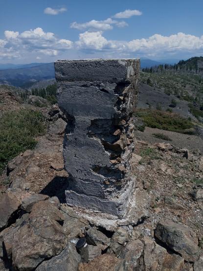
Never found a triangulation station like this before!
#geography #station #survey #surveyors
#surveyors: You know you can't actually *trust* #GIS maps, right? Don't even bother with that stuff and come to us.
Also #surveyors: Where is the label for this boundary on your web map? I really need to know the measurement here.
I’m flabbergasted and not a little impressed by the #surveyors’ precision evident on this early #NineteenthCentury cast #iron #mile marker. I have seen distances recorded to the nearest 1/4 mile (440yd resolution); distances recorded to the nearest furlong (220yd resolution); but never one recording distance to the nearest #yard!!! I wonder who needed to know it was exactly 1056yds to Stocks? #Roads #LandscapeHistory (I know I’m cheating but it’s too good not to tag with #FingerPostFriday)
Contrast my last #photo of an #old #lane with these ‘new’ ones walked today. #EighteenthCentury post-#enclosure #field lane. Unnaturally #straight courses, drawn by #Surveyors, unsympathetic to the grain of the country. They speak of #capitalism, #exploitation, the #privatisation of #land, the rise of #individualism, the debasement of #community, and the eradication of #Common #Rights. In more than one way, these lifeless lanes symbolise how we have destroyed #society in the last 200 years.
This is why you can get a 1:2000 Ordinance map for any part of the UK.
“For centuries, though, no one had set out to systematically and accurately map the British isles in their entirety. It was not until the 19th century that os created the first comprehensive, detailed picture of #Britain. Just as today’s paper os #maps fit together in a jigsaw that stretches over the country, when os began its #cartographic project around 1800 it progressed sheet by sheet. The task would take eight decades and involved considerable hardship for the hundreds of #surveyors employed to carry it out.”
#ordinance #os / #cartography / #surveying <https://economist.com/interactive/britain/2023/04/06/how-intrepid-victorian-surveyors-mapped-the-length-and-breadth-of-britain>
Surveyors and flag. #snapshot #photography #surveyors #flag
https://archive.org/details/whos-who-kenya-1982-83
Who is Who in Kenya 1982-1983 by Mutuku Nzioki; J.M. Ng'ang'a; R. G. Opondo; Talat Dar; M.B. Dar; Josaphat O. Mithiga; David M. Mbiti
Topics
#Kenya, #Kenyansociety, #Kenyanelite, #neocolonialism, #neocolonialists, #compradorbourgeoisie, #pettybourgeoisie, #KANU, #KenyaAfricanNationalUnion, #Kenyanpolitics, #politicsofKenya, #Kenyangovernment, #governmentofKenya, #educationinKenya, #Kenyaneducation, #universitiesinKenya, #Kenyanuniversities, #accountancy, #accountants, #auditing, #auditors, #architecture, #architects, #surveyors, #engineers, #engineering, #journalists, #Kenyanlaw, #lawinKenya, #Kenyanlawyers, #Kenyanlegalsystem, #librarians, #archivist, #LIS, #libraryandinformationscience, #Kenyanmuseums, #museumsinKenya, #Kenyanlibraries, #Kenyanarchives, #medicineinKenya, #Kenyanmedicine, #veterinarians, #Kenyancapitalists, #capitalisminKenya, #capitalists, #tradeunions, #tradeunionists, #Kenyanreligions, #religioninKenya, #Kenyanbourgeoisie
Nairobi: Africa Book Services (E.A.) Ltd.
