#wgs84

Kevin Karhan :verified:kkarhan@infosec.space
2025-05-02

@KathrinBB was virallem passieren wird ist "hydrostatische Rebalance".

  • Falls mensch sich fragt, warum nen Freiband nicht im Winter das Schwimmbecken entleert (Der Betonboden würde nach oben aufbrechen!), mag sich das gleiche mit bis zu 3km Eis in Grönland und bis zu 4km Eis in der Antarktis vorstellen.

In der letzten eisfreien Zeit war der #Meeresspielgel 135m über #WGS84 - "Normalnull" und die #Eifel nen #Korallenriff!

Wenn ich richtig liege lebt über die Hälfte aller Menschen und 85% aller Nahrungsmittelproduktion im Bereich ≤150m Höhe...
2024-08-27

Kennt sich jemand mit OpenLayers aus? Ich versuche Wetterdaten auf einer Karte darzustellen. Ich kann die Daten anzeigen, aber die sind West-Ost gespreizt. Irgendwas mache ich mit den Projektionen falsch (siehe im PDF unten),
- Eckkoordinaten sind wohl WGS84
- die Messdaten wurden von da per diesem proj-String auf die Ebene projiziert (???)
- für OpenLayers muss entweder mein view diese proj verwenden, oder es muss umgemapt werden ???

dwd.de/DE/leistungen/radarprod
#openlayers #wgs84 #gis

2024-07-17

No a abych šel s dobou, doplnil jsem ještě sloupečky long, lat kde jsou souřadnice přepočítány do #WGS84

Luís de Sousaluis_de_sousa
2024-07-04

Today's address on the by @jjimenezshaw at the -Europe is one the most relevant in this conference. Especially if you care about location accuracy/uncertainty.

talks.osgeo.org/foss4g-europe-

AGR Risk Intelligenceagr@pleroma.envs.net
2024-05-21
**Every map of China is wrong**
_And this is intentional…_
-- Anastasia Bizyayeva

https://medium.com/@anastasia.bizyayeva/every-map-of-china-is-wrong-bc2bce145db2

#China #GPS #WGS84 #Mapping
GripNewsGripNews
2024-05-16

🌗 StephaneP的日記 | 你以為OpenStreetMap數據使用WGS84基準?不,它不是!
➤ WGS84座標基準系統的限制與其他座標基準系統的優缺點。
openstreetmap.org/user/Stephan
本文討論了OpenStreetMap數據使用的基準系統問題。WGS84座標基準系統並不適用於所有地區,因為各板塊這些年移動了很多,所以使用靜態座標基準系統更準確。某些國家的航空影像數據使用的是當地座標基準系統,而不是WGS84。文章討論了在選擇使用哪種座標基準系統方面所面臨的挑戰。
+ 這是一篇很有趣的文章,謝謝作者的解釋。
+ 對於一般使用者來說,這些座標基準系統的差異太小,不會對他們的使用體驗產生太大影響。

2024-05-10

Karten von China sind mehrheitlich absichtlich falsch - weil China darauf besteht, ein bewusst ungenau gemachtes #Geodaten-Referenzsystem zu nutzen. medium.com/@anastasia.bizyayev #wgs84

2024-05-06

@eivind Så sant. Men likevel: dersom ein skal laga ein kart-applikasjon må ein i det minste setja seg inn i kva for ein transformasjon ein skal bruka. hæsjtægg #wgs84.

Jakob Mikschjakobmiksch
2024-05-04

Built a webmap to generate random geodata with export to or

Besides (latitude/longitude) all projections are supported dynamically by location

Thanks to this works completely in the browser and does not require server processing 🤩

Demo: jakobmiksch.github.io/random-g
Repo: github.com/jakobMiksch/random-

Sven Ruppertsvenruppert
2023-12-18

Something of personal interest is the coordinate system. This is the base for most electronic and systems like and much more

svenruppert.com/2023/12/18/wha

Sven Ruppertsvenruppert
2023-12-18

What is WGS84 – An Overview
The World Geodetic System 1984 (WGS 84) is a geodetic reference system used to describe the shape and size of the Earth. We will delve into its historical context, technical specifications, global significance, and practical applications. 

Introduction: Understanding Geodetic Reference SystemsHistorical Evolution of Ge
svenruppert.com/2023/12/18/wha

Kevin Karhan :verified:kkarhan@mstdn.social
2023-08-07

@B_Whitewind Yeah...

Basically Florida's Economy is fucked for decades if not centuries, unless it'll become a #WreckDiving & #DeepDiving spot when the poles melt away and hydrostatic rebalance will result in 135m higher #sealevel compared to #WGS84...
bikeshed.party/objects/02ed014

Kevin Karhan :verified:kkarhan@mstdn.social
2023-06-26

@glynmoody "Worst Case" based off historical data is 135m above #WGS84 based off hydrostatic rebalance and historical levels.

Aka.: The #Eifel would be a #CoralReef again!
en.m.wikipedia.org/wiki/Eifel

Andreas Scherbaumascherbaum
2019-01-08

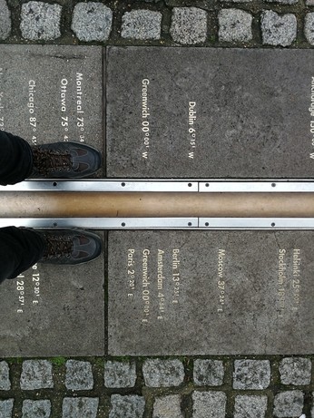
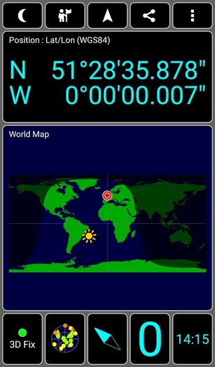
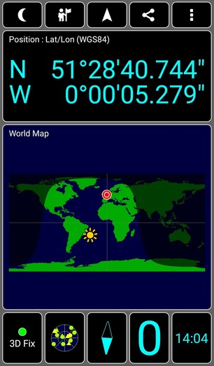
The at the Royal Observatory in is not exactly at longitude 0 - but instead about a 100 meters to the east.

That's because GPS is based on (geodetic system) and the Prime Meridian is based on the astronomical longitude

Client Info

Server: https://mastodon.social
Version: 2025.04
Repository: https://github.com/cyevgeniy/lmst