Did you feel shaking in the San Francisco Bay area this evening?
Thousands did!
That was a M3.7 earthquake about 18 km south of San Francisco at 6:38 p.m. PT.
Details (USGS): https://earthquake.usgs.gov/earthquakes/eventpage/nc73952475/executive
John Cassidy
NRCan earthquake seismologist and University of Victoria (Earth and Ocean Sciences) Adjunct Professor. Works with engineers, emergency managers, and communities to minimize the impact of #earthquakes. My thoughts/posts.
Geological Survey of Canada

John Cassidy boosted:

#Earthquake 13 mi SW of #Camano (#Washington) 22 min ago (local time 19:21:08). Updated map - Colored dots represent local shaking & damage level reported by eyewitnesses. Share your experience via:
📱http://www.emsc-csem.org/lastquake/information_channels/lastquake_app/
🌐http://m.emsc.eu/?id=1563689

Did you feel shaking on the northern #California coast this morning?
That was a M4.7 #earthquake near Ferndale, CA at 8:26 a.m. PT.
Details from the USGS (and report shaking here):
https://earthquake.usgs.gov/earthquakes/eventpage/nc73943821/executive
No tsunami threat.
https://www.tsunami.gov/

@BJDeming
Thanks for your kind words. I always enjoy the posts that you share - thank you!
@BJDeming
Thanks for this. Also - it is great to see you here!
For original notes, photos and damage reports from the Canadian side for the 1944 earthquake - see:
https://articles.adsabs.harvard.edu//full/1945JRASC..39....5H/0000005.000.html
John Cassidy boosted:

@Earthquakeguy They still remember this in Massena, as I recall from living in upstate New York. And it was in the Adirondacks that I felt a three-pointer in the early 1980s, though that was centered in New Hampshire (I was in Paul Smiths, attending the college with that name and, believe it or not, living off campus on Easy Street!). Very poorly constructed housing (an old tourist cabin) and the shaking opened kitchen cabinet doors 😎 .
Different source from this, though:
https://www.adirondackalmanack.com/2012/10/the-massena-earthquake-of-1944.html
#Earthquakes continue ~120 km off the northern end of #VancouverIsland.
Following a few dozen M3-4 earthquakes last Thursday, a M5.5 struck at 4:28 a.m. today.
No damage, no tsunami.
Details:
https://earthquakescanada.nrcan.gc.ca/recent/2023/20230917.1128/index-en.php
If you felt shaking please report it here:
https://earthquakescanada.nrcan.gc.ca/dyfi-lavr/form-en.php?eventid=20230917.1128
See live ground shaking:
https://earthquakescanada.nrcan.gc.ca/stndon/wf-fo/index-en.php#/CN.HOLB..


@Nazani
Thanks, you are exactly right - the older structures in the east are more susceptible to damage.
There are also differences in the earth - in the East the old and stable rocks transmit seismic waves more effectively (especially the high-frequency shaking that impacts smaller, rigid structures). In the West the younger and more complicated earth structure is better at absorbing seismic waves. If you haven't seen this USGS webpage, you might be interested!
https://www.usgs.gov/news/featured-story/east-vs-west-coast-earthquakes
Damaging earthquakes in eastern #NorthAmerica ?
Not so often - but, yes.
On this day in 1944 a damaging M5.8 #earthquake struck near Cornwall, #ON and Massena, #NY. Chimneys came crashing down and many masonry structures were damaged. Felt from Quebec City to New York City to Toronto. Details: http://earthquakescanada.nrcan.gc.ca/historic-historique/events/19440905-en.php… http://adsabs.harvard.edu/full/1945JRASC..39....5H

Time flies!
Today marks 125 years of seismic recording of #earthquakes in #Victoria, Canada!
On September 3, 1898, a Milne #seismograph began operation in the basement of the old Customs House building on the Victoria waterfront. It was one of the first seismographs in Canada (and one of very few operating in the world at the time):
http://science.gc.ca/eic/site/063.nsf/eng/97237.html…
Seeing through the #ocean...
This is a section of the strike-slip Queen Charlotte Fault (just to the west of Haida Gwaii) that broke 74 years ago tonight during an offshore M8.1 #earthquake.
The Pacific plate slipped ~5 m to the northwest relative to North America (this only took ~2-3 minutes). We can clearly see this #fault on the seafloor thanks to modern seafloor mapping technology. Results of this research show us where the faults are located, how much they have moved and how often.

Large earthquakes in #Canada ?
On this day in 1949, a damaging M8.1 #earthquake (one of the largest ever recorded in #NorthAmerica) struck off #HaidaGwaii. Shaking was so strong that cows were knocked off their feet and a geologist working close to the epicentre could not stand up.
Shaking was felt across most of #BritishColumbia, parts of Alberta, #washington Yukon and Alaska: https://earthquakescanada.nrcan.gc.ca/historic-historique/events/19490822-en.php

You are never far from a #lighthouse on #VancouverIsland This is historic Fisgard Lighthouse, near #Victoria.

Were you rudely awakened by shaking in northwest #Washington at 03:17 this morning?
Hundreds of people were...
That was a M3.8 #earthquake located about 40 km to the east of #Seattle. Shaking was felt to distances of ~100 km.
Details from the #PNSN/USGS:
https://earthquake.usgs.gov/earthquakes/eventpage/uw61939452/executive
More on #PacificNorthwest earthquakes:
https://pnsn.org/outreach/earthquakesources


Are you interested in #Canadian #geoscience?
#earthquakes #landslides #tsunamis #geology #mining #energy #marine geoscience and so much more?
You can find #publications from the #Geological Survey of Canada (established in 1842) via Geoscan.
Search by region, keyword, author and more:
https://geoscan.nrcan.gc.ca/starweb/geoscan/servlet.starweb?path=geoscan/geoscan_e.web
More on the GSC:
https://natural-resources.canada.ca/research-centres-and-labs/geological-survey-canada/17100

@zl2tod Thanks very much for sending this article!
After thousands of small #earthquakes were recorded, and a M5.1 yesterday (as magma was breaking rock on its way to the surface), the #volcanic eruption on the Reykjanes Peninsula, #Iceland has begun.
See the live stream at:
youtube.com/watch?v=yJfiMhqLgTY
https://www.ruv.is/english
More information from the Iceland Meteorological Office:
https://en.vedur.is/
Happy Canada Day 🇨🇦 from the Salish Sea near southern #VancouverIsland.
#Islands, sailboats and a #volcano in the #Pacific


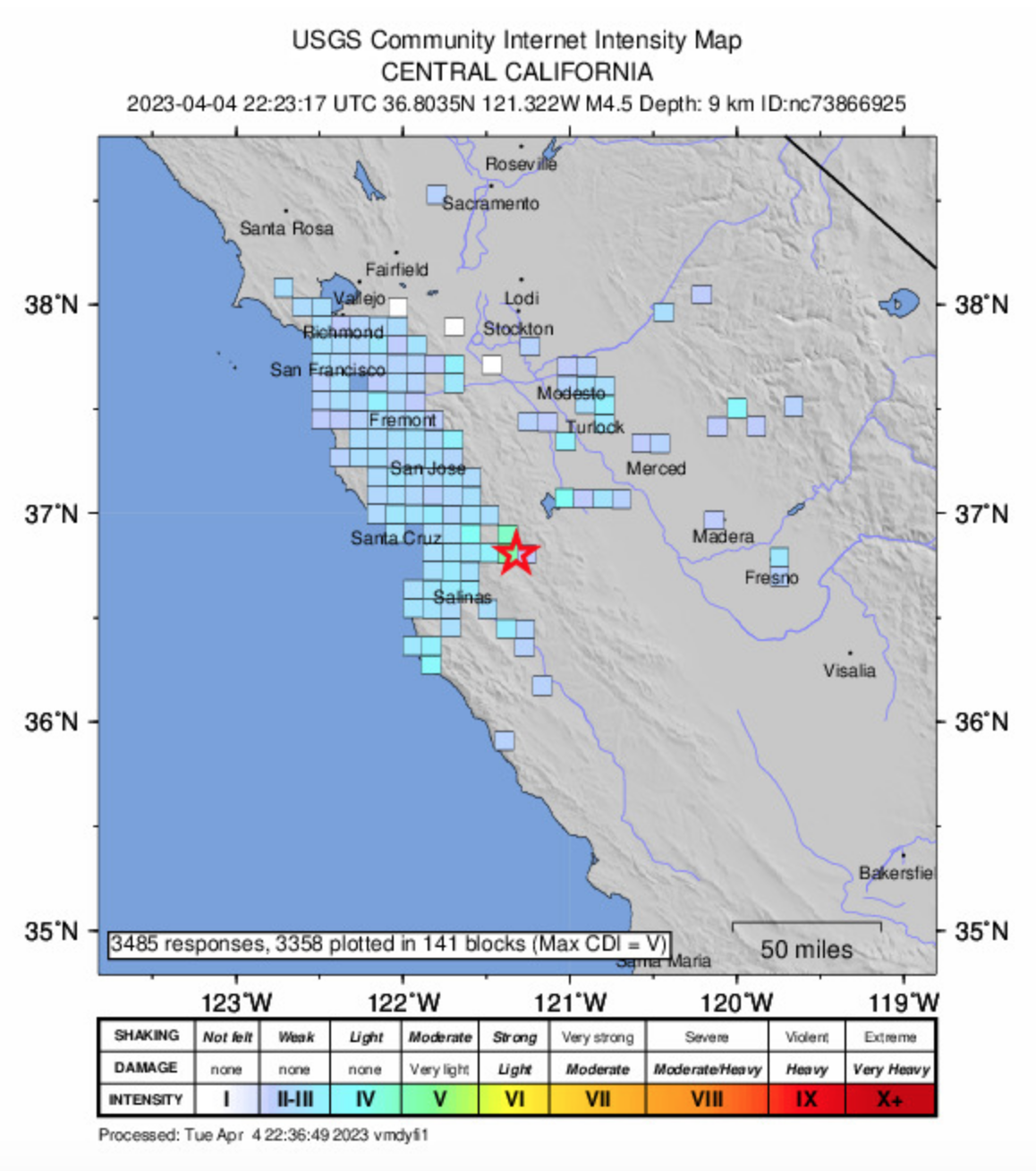
Did you feel shaking in central #California a short time ago? At 3:23 p.m. PT there was a M4.5 #earthquake located about 32 km ENE of Salinas. Shaking was felt by 1000's across central California.
Details: https://earthquake.usgs.gov/earthquakes/eventpage/nc73866925/region-info
Report #shaking here: https://earthquake.usgs.gov/earthquakes/eventpage/nc73866925/tellus
March 27, 1964 - one of the world's largest earthquakes (a M9.2 subduction #earthquake) struck southern #Alaska. Shaking was felt throughout Alaska as well as across much of #BritishColumbia and #Yukon. The resulting tsunami caused damage along the west coast from #Alaska to #California. Several coastal communities along the British Columbia coast were impacted.
More details (USGS): https://earthquake.usgs.gov/earthquakes/events/alaska1964/
Video: https://youtube.com/watch?v=L6TBcOpDLv0

Client Info
Server: https://mastodon.social
Version: 2025.07
Repository: https://github.com/cyevgeniy/lmst