#apx

2025-10-12

#APX #MIwx 048
FXUS63 KAPX 121654 CCA
AFDAPX

Area Forecast Discussion...CORRECTED
National Weather Service Gaylord MI
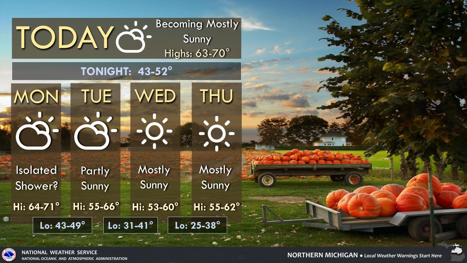
1254 PM EDT Sun Oct 12 2025

.KEY MESSAGES...

- Warmer today and Monday, more seasonable rest of the week.

- Few light showers possible Monday.

- Unsettled ~late week/next weekend?

&&

.SHORT TERM /THROUGH TONIGHT/...
Issued at 202 AM EDT Sun Oct 12 2025

Pattern Synopsis and Forecast:

Upper low lingers across NY/PA today, with no impact for us mesonet.agron.iastate.edu/p.ph

2025-10-12

#APX issues Area Forecast Discussion (AFD) at Oct 12, 12:54 PM EDT mesonet.agron.iastate.edu/p.ph

2025-10-12

#APX #MIwx 712
FXUS63 KAPX 121647
AFDAPX

Area Forecast Discussion
National Weather Service Gaylord MI
1247 PM EDT Sun Oct 12 2025

.KEY MESSAGES...

- Warmer today and Monday, more seasonable rest of the week.

- Few light showers possible Monday.

- Unsettled ~late week/next weekend?

&&

.SHORT TERM /THROUGH TONIGHT/...
Issued at 202 AM EDT Sun Oct 12 2025

Pattern Synopsis and Forecast:

Upper low lingers across NY/PA today, with no impact for us up here
in nort mesonet.agron.iastate.edu/p.ph

2025-10-12

#APX issues Area Forecast Discussion (AFD) at Oct 12, 12:47 PM EDT mesonet.agron.iastate.edu/p.ph

2025-10-12

#APX #MIwx 435
NOUS43 KAPX 121357
PNSAPX

Public Information Statement
National Weather Service Gaylord MI
957 AM EDT Sun Oct 12 2025

Northern Michigan Temperature and Precipitation Summary

Yesterday's High Temperature...12 hour Low ending 8 am EDT
24 hour Precipitation/Snowfall ending 8 am EDT
Snow Depth observed at 8 am EDT

.BR APX 1012 ES DH00/TAIRZX/DH07/TAIRZP/PPDRZZ/SFDRZZ/SDIRZZ
:.....................................................................
: mesonet.agron.iastate.edu/p.ph

2025-10-12

#APX issues Public Information Statement (PNS) at Oct 12, 9:57 AM EDT ....... mesonet.agron.iastate.edu/p.ph

2025-10-12

#APX #MIwx 514
FLUS43 KAPX 121152
HWOAPX

Hazardous Weather Outlook
National Weather Service Gaylord MI
752 AM EDT Sun Oct 12 2025

MIZ016>018-020>036-041-042-086>088-095>099-131200-
Emmet-Cheboygan-Presque Isle-Leelanau-Antrim-Otsego-Montmorency-
Alpena-Benzie-Grand Traverse-Kalkaska-Crawford-Oscoda-Alcona-
Manistee-Wexford-Missaukee-Roscommon-Ogemaw-Iosco-Gladwin-Arenac-
Western Chippewa-Central Chippewa-Southeast Chippewa-
Western Mackinac-Eastern Mackinac-
Mackinac mesonet.agron.iastate.edu/p.ph

2025-10-12

#APX issues Hazardous Weather Outlook (HWO) at Oct 12, 7:52 AM EDT mesonet.agron.iastate.edu/p.ph

2025-10-12

#APX #MIwx 350
WWUS73 KAPX 121150
NPWAPX

URGENT - WEATHER MESSAGE
National Weather Service Gaylord MI
750 AM EDT Sun Oct 12 2025

MIZ032>035-121400-
/O.NEW.KAPX.FG.Y.0001.251012T1150Z-251012T1400Z/
Wexford-Missaukee-Roscommon-Ogemaw-
750 AM EDT Sun Oct 12 2025

...DENSE FOG ADVISORY IN EFFECT UNTIL 10 AM EDT THIS MORNING...

* WHAT...Visibility one quarter mile or less in dense fog.

* WHERE...Missaukee, Ogemaw, Roscommon, and Wexford Counties.

* WHEN...Until 10 AM E mesonet.agron.iastate.edu/vtec

2025-10-12

#APX #MIwx 176
WWUS83 KAPX 121144
SPSAPX

Special Weather Statement
National Weather Service Gaylord MI
744 AM EDT Sun Oct 12 2025

MIZ016>018-020>036-041-042-086>088-095>099-121400-
Emmet-Cheboygan-Presque Isle-Leelanau-Antrim-Otsego-Montmorency-
Alpena-Benzie-Grand Traverse-Kalkaska-Crawford-Oscoda-Alcona-
Manistee-Wexford-Missaukee-Roscommon-Ogemaw-Iosco-Gladwin-Arenac-
Western Chippewa-Central Chippewa-Southeast Chippewa-
Western Mackinac-Eastern Mackinac-
Mackinac mesonet.agron.iastate.edu/p.ph

2025-10-12

#APX #MIwx 908
FXUS63 KAPX 121041
AFDAPX

Area Forecast Discussion
National Weather Service Gaylord MI
641 AM EDT Sun Oct 12 2025

.KEY MESSAGES...

- Warmer today and Monday, more seasonable rest of the week.

- Few light showers possible Monday.

- Unsettled ~late week/next weekend?

&&

.SHORT TERM /THROUGH TONIGHT/...
Issued at 202 AM EDT Sun Oct 12 2025

Pattern Synopsis and Forecast:

Upper low lingers across NY/PA today, with no impact for us up here
in north mesonet.agron.iastate.edu/p.ph

2025-10-12

#APX issues Area Forecast Discussion (AFD) at Oct 12, 6:41 AM EDT mesonet.agron.iastate.edu/p.ph

2025-10-12

National Weather Service - Gaylord, MI #MIwx #APX #NWS #WX

2025-10-12

#APX #MIwx 583
FXUS63 KAPX 120603
AFDAPX

Area Forecast Discussion
National Weather Service Gaylord MI
203 AM EDT Sun Oct 12 2025

.KEY MESSAGES...

- Warmer today and Monday, more seasonable rest of the week.

- Few light showers possible Monday.

- Unsettled ~late week/next weekend?

&&

.SHORT TERM /THROUGH TONIGHT/...
Issued at 202 AM EDT Sun Oct 12 2025

Pattern Synopsis and Forecast:

Upper low lingers across NY/PA today, with no impact for us up here
in north mesonet.agron.iastate.edu/p.ph

2025-10-12

#APX issues Area Forecast Discussion (AFD) at Oct 12, 2:03 AM EDT mesonet.agron.iastate.edu/p.ph

2025-10-12

#APX #MIwx 608
CDUS43 KAPX 120521
CLITVC

CLIMATE REPORT
NATIONAL WEATHER SERVICE
121 AM EDT SUN OCT 12 2025

...................................

...THE TRAVERSE CITY MI CLIMATE SUMMARY FOR OCTOBER 11 2025...

CLIMATE NORMAL PERIOD: 1991 TO 2020
CLIMATE RECORD PERIOD: 1896 TO 2025

WEATHER ITEM OBSERVED TIME RECORD YEAR NORMAL DEPARTURE LAST
VALUE (LST) VALUE VALUE FROM YEAR
mesonet.agron.iastate.edu/p.ph

2025-10-12

#APX #MIwx 605
CDUS43 KAPX 120521
CLIAPN

CLIMATE REPORT
NATIONAL WEATHER SERVICE
121 AM EDT SUN OCT 12 2025

...................................

...THE ALPENA MI CLIMATE SUMMARY FOR OCTOBER 11 2025...

CLIMATE NORMAL PERIOD: 1991 TO 2020
CLIMATE RECORD PERIOD: 1916 TO 2025

WEATHER ITEM OBSERVED TIME RECORD YEAR NORMAL DEPARTURE LAST
VALUE (LST) VALUE VALUE FROM YEAR
NOR mesonet.agron.iastate.edu/p.ph

2025-10-12

#APX #MIwx 604
CDUS43 KAPX 120521
CLIANJ

CLIMATE REPORT
NATIONAL WEATHER SERVICE
121 AM EDT SUN OCT 12 2025

...................................

...THE SAULT STE MARIE MI CLIMATE SUMMARY FOR OCTOBER 11 2025...

CLIMATE NORMAL PERIOD: 1991 TO 2020
CLIMATE RECORD PERIOD: 1888 TO 2025

WEATHER ITEM OBSERVED TIME RECORD YEAR NORMAL DEPARTURE LAST
VALUE (LST) VALUE VALUE FROM YEAR
mesonet.agron.iastate.edu/p.ph

2025-10-12

#APX #MIwx 609
CDUS43 KAPX 120521
CLIHTL

CLIMATE REPORT
NATIONAL WEATHER SERVICE
121 AM EDT SUN OCT 12 2025

...................................

...THE HOUGHTON LAKE MI CLIMATE SUMMARY FOR OCTOBER 11 2025...

CLIMATE NORMAL PERIOD: 1991 TO 2020
CLIMATE RECORD PERIOD: 1913 TO 2025

WEATHER ITEM OBSERVED TIME RECORD YEAR NORMAL DEPARTURE LAST
VALUE (LST) VALUE VALUE FROM YEAR
mesonet.agron.iastate.edu/p.ph

2025-10-12

#APX #MIwx 557
FXUS63 KAPX 120518
AFDAPX

Area Forecast Discussion
National Weather Service Gaylord MI
118 AM EDT Sun Oct 12 2025

.KEY MESSAGES...

- Patchy fog possible tonight

- Brief warming for Sunday and Monday

- Clouds, cooler temperatures, and brief rain chances return late
Monday into Tuesday

- Seasonal temperatures, light winds, and generally sunny skies mid
week into next weekend

&&

.SHORT TERM /THROUGH MONDAY/...
Issued at 243 PM EDT Sat Oct 11 2025 mesonet.agron.iastate.edu/p.ph

Client Info

Server: https://mastodon.social
Version: 2025.07
Repository: https://github.com/cyevgeniy/lmst