#OTD in Weather History: December 11, 2008. A significant ice storm impacted northern Massachusetts and southern New Hampshire.
NWS Boston
[Shadow of] Official Twitter Account for National Weather Service - Boston / Norton, MA.
Details: http://weather.gov/twitter
Radar showing a brief lull in rainfall over central MA/RI at this hour, but another round of moderate to heavy rainfall will move in from the west through the mid-afternoon and evening hours. This will be accompanied by strong to potentially damaging wind gusts from 50-60 mph
#OTD in Weather History: December 10-12, 1960. Blizzard conditions were reported from the mid Atlantic to New England.
Because of the active weather we will not be doing our routine weekly NOAA weather radio test at 11AM. The test will be completed tomorrow instead.
[Morning Briefing] Black ice is possible for the morning commute across parts of central/northeast MA. Otherwise...strong to damaging wind gusts with heavy rain and the potential for flooding are the focus of the forecast Wed into Wed night.
[Heavy Rain With Strong to Damaging Wind Gusts Into This Evening] Periods of rain will be heavy at times, especially late today into this evening. This may result in the potential for flooding. In addition...strong to damaging wind gusts will develop later today into the evening.
[Wed Forecast] Here is a radar simulation (not expected to be exact) from Tue evening through Wed night. A windswept rain expected, impacting both the AM & PM commutes Wed. Widespread 2-3" of rain, localized 4" amounts possible. Strong winds/power outages possible eastern MA/RI
[Wed into Wed night] An impactful storm will bring heavy rainfall and strong coastal winds to SNE. Localized urban and poor drainage street flooding is possible with 50-60 mph wind gusts near the coast. The heaviest rain and strongest wind is expected late Wed and Wed evening.
#OTD in Weather History: December 9, 2005. A rapidly intensifying winter storm brought brief blizzard conditions and hurricane force winds.
After a dry first half of the day, rain and even some high elevation freezing rain/icing are possible tonight into Tuesday. Check your forecast at https://weather.gov/boston
Quite the roller coaster of temperatures coming up with a big warm up mid week followed by much colder air for the end of the week.
Looking rather wet this week, especially Tuesday night into Wednesday night. Mostly rainfall. Low risk for some icing along and north of Route 2 and towards the Berkshires Monday night into Tuesday. More significant rainfall towards mid-week, then drier late this week.
Expecting a period of light snow overnight. Very modest event, but some will wake up to a coating to an inch of snow. Milder temperatures return tomorrow afternoon with highs in the mid to upper 40s. Gusty southwest winds for the first half of the day, especially for Cape/Islands
Several rounds of wet weather are in store over the next week. The first is a quick hitting round of light snow Saturday night, then rain late Monday into Tuesday and heavier rain on Wednesday. Check back at https://weather.gov/boston for your local forecast.
#OTD in Weather History: December 7, 1941. Today we remember the attack on Pearl Harbor which thrust the U.S. into World War II. Weather observations taken at Hickam Field noted the attack that Sunday morning.
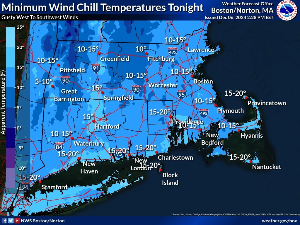
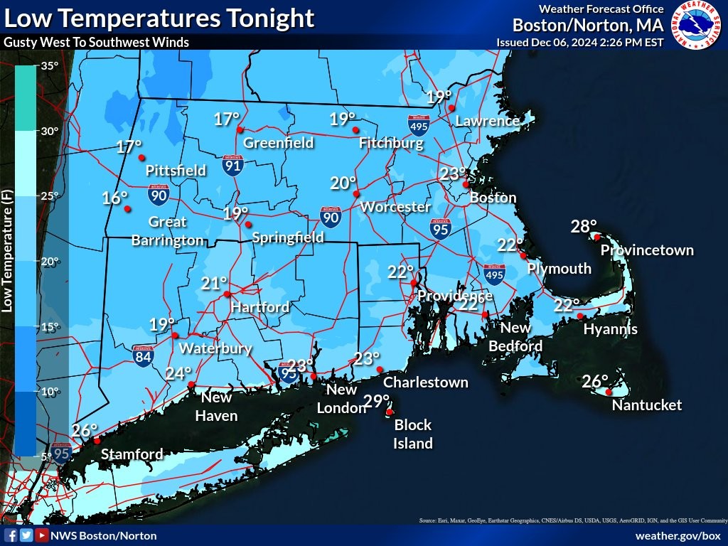
Low temperatures mainly from 15-25 degrees tonight across southern New England. However, gusty westerly winds will make it feel as much as 10-15 degrees colder.
Looking for a break from these cold temperatures?🥶 Look no further than next week when we're expecting a decent warm Tuesday into Wednesday. 🌡️
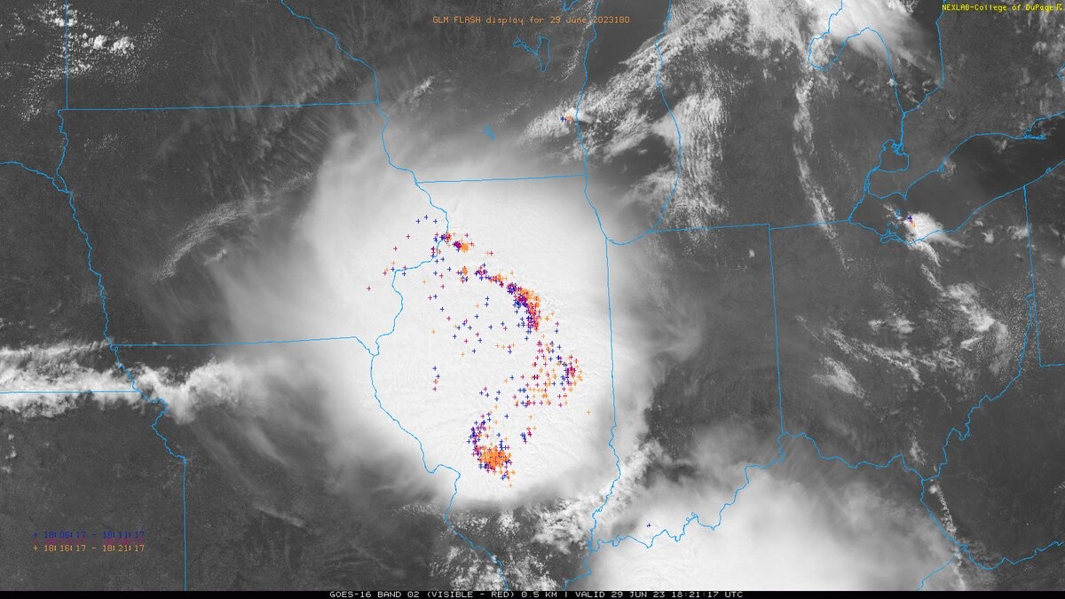
[4 PM] Tranquil weather here in Southern New England, but quite the #thunderstorm complex currently over IL into IN. Notice the bowing configuration of the #lightning flashes, indicative of a #severe wind signature.
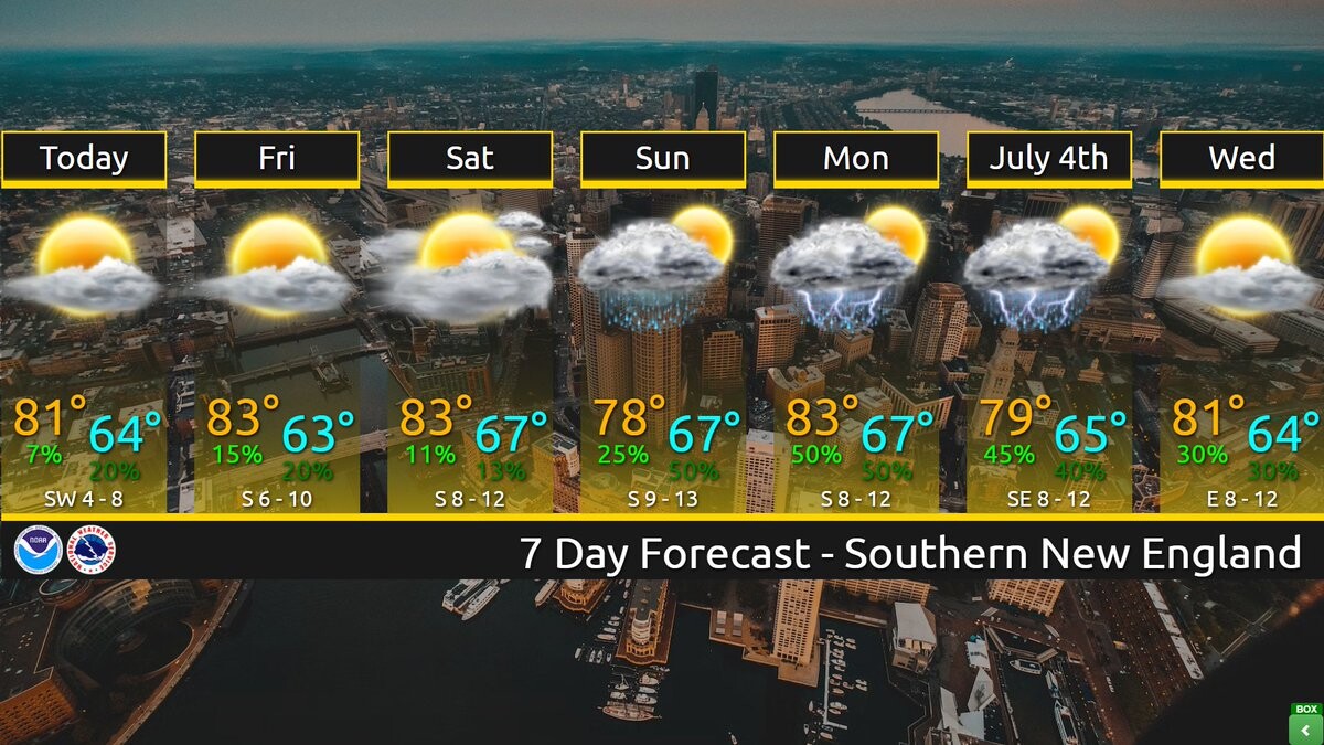
[7 Day Forecast] Mainly dry weather other than a brief spot shower today through Saturday. The humidity returns Sunday, Monday and Independence Day with the potential of scattered showers & thunderstorms especially during the afternoon and evening but not expecting a washout.
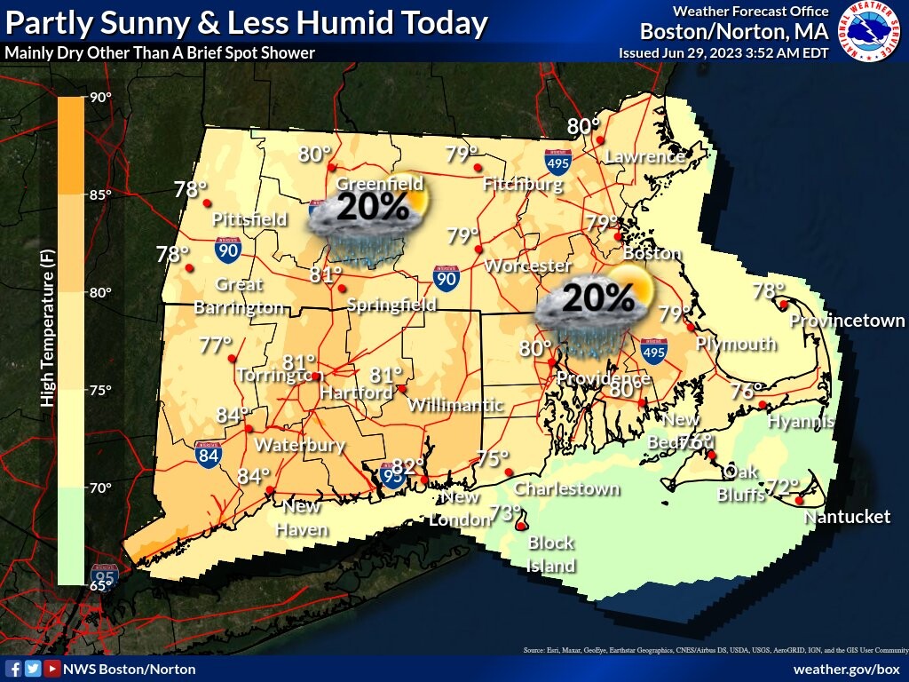
[Today] Partly sunny and a bit less humid today. Mainly dry weather expected other than perhaps a brief spot shower or two in the afternoon. Highs will generally be in the upper 70s to the lower 80s.
Client Info
Server: https://mastodon.social
Version: 2025.04
Repository: https://github.com/cyevgeniy/lmst