#ABR
#ABR #SDwx 254
NWUS53 KABR 251840
LSRABR
Preliminary Local Storm Report
National Weather Service Aberdeen SD
140 PM CDT Wed Jun 25 2025
..TIME... ...EVENT... ...CITY LOCATION... ...LAT.LON...
..DATE... ....MAG.... ..COUNTY LOCATION..ST.. ...SOURCE....
..REMARKS..
0139 PM Flood Milbank 45.22N 96.63W
06/25/2025 Grant SD CO-OP Observer
Standing water in farm fi https://mesonet.agron.iastate.edu/lsr/?by=wfo&wfo=ABR&sts=202506251839&ets=202506251839
#ABR #SDwx 254
NWUS53 KABR 251840
LSRABR
Preliminary Local Storm Report
National Weather Service Aberdeen SD
140 PM CDT Wed Jun 25 2025
..TIME... ...EVENT... ...CITY LOCATION... ...LAT.LON...
..DATE... ....MAG.... ..COUNTY LOCATION..ST.. ...SOURCE....
..REMARKS..
0139 PM Flood Milbank 45.22N 96.63W
06/25/2025 Grant SD CO-OP Observer
Standing water in farm fi https://mesonet.agron.iastate.edu/lsr/?by=wfo&wfo=ABR&sts=202506251828&ets=202506251828
#ABR #SDwx 104
NWUS53 KABR 251826
LSRABR
Preliminary Local Storm Report
National Weather Service Aberdeen SD
126 PM CDT Wed Jun 25 2025
..TIME... ...EVENT... ...CITY LOCATION... ...LAT.LON...
..DATE... ....MAG.... ..COUNTY LOCATION..ST.. ...SOURCE....
..REMARKS..
0126 PM Rain 1 NNE Watertown 44.91N 97.10W
06/25/2025 M2.50 Inch Codington SD Public
from Social Media report. https://mesonet.agron.iastate.edu/lsr/?by=wfo&wfo=ABR&sts=202506251826&ets=202506251826
#ABR #SDwx 104
NWUS53 KABR 251826
LSRABR
Preliminary Local Storm Report
National Weather Service Aberdeen SD
126 PM CDT Wed Jun 25 2025
..TIME... ...EVENT... ...CITY LOCATION... ...LAT.LON...
..DATE... ....MAG.... ..COUNTY LOCATION..ST.. ...SOURCE....
..REMARKS..
0126 PM Rain 1 NNE Watertown 44.91N 97.10W
06/25/2025 M2.50 Inch Codington SD Public
from Social Media report. https://mesonet.agron.iastate.edu/lsr/?by=wfo&wfo=ABR&sts=202506251824&ets=202506251824
#ABR #SDwx 478
NWUS53 KABR 251818
LSRABR
Preliminary Local Storm Report
National Weather Service Aberdeen SD
118 PM CDT Wed Jun 25 2025
..TIME... ...EVENT... ...CITY LOCATION... ...LAT.LON...
..DATE... ....MAG.... ..COUNTY LOCATION..ST.. ...SOURCE....
..REMARKS..
0116 PM Fog 5 S Summit 45.24N 97.05W
06/25/2025 E0.25 Mi Grant SD CO-OP Observer
Fog noted from I-29 Wilmo https://mesonet.agron.iastate.edu/lsr/?by=wfo&wfo=ABR&sts=202506251816&ets=202506251816
#ABR #SDwx 940
NWUS53 KABR 251816
LSRABR
Preliminary Local Storm Report
National Weather Service Aberdeen SD
116 PM CDT Wed Jun 25 2025
..TIME... ...EVENT... ...CITY LOCATION... ...LAT.LON...
..DATE... ....MAG.... ..COUNTY LOCATION..ST.. ...SOURCE....
..REMARKS..
1125 AM Rain 4 NE Conde 45.20N 98.04W
06/25/2025 E3.00 Inch Spink SD Public
from Social Media report. https://mesonet.agron.iastate.edu/lsr/?by=wfo&wfo=ABR&sts=202506251500&ets=202506251800
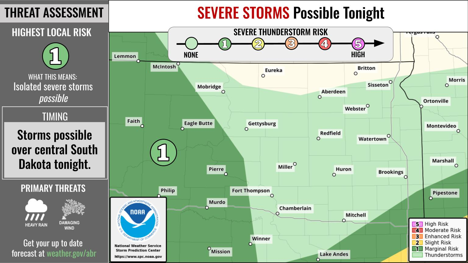
#ABR #SDwx 969
FXUS63 KABR 251744 AAC
AFDABR
Area Forecast Discussion...UPDATED
National Weather Service Aberdeen SD
1244 PM CDT Wed Jun 25 2025
.KEY MESSAGES...
- There is a 40-80 percent chance for showers and thunderstorms
today. Some storms could be strong with hail and locally strong
winds. The larger threat will be heavy rainfall with the
potential to see at least 1 inch or more of rainfall which could
lead to the possibility for localized flooding.
https://mesonet.agron.iastate.edu/p.php?pid=202506251744-KABR-FXUS63-AFDABR-AAC
#ABR #SDwx 165
WWUS83 KABR 251718
SPSABR
Special Weather Statement
National Weather Service Aberdeen SD
1218 PM CDT Wed Jun 25 2025
SDZ008-011-020-021-252030-
Roberts-Day-Codington-Grant-
Including the cities of Sisseton, Webster, Watertown, and Milbank
1218 PM CDT Wed Jun 25 2025
...AREAS OF REDUCED VISIBILITIES...
Webcams and reports indicate reduced visibilities, of a half mile
or less, due to low clouds/dense fog over portions of the higher
elevations of the S https://mesonet.agron.iastate.edu/p.php?pid=202506251718-KABR-WWUS83-SPSABR
#ABR #SDwx 347
AWUS01 KWNH 251654
FFGMPD
WIZ000-MNZ000-IAZ000-SDZ000-252300-
Mesoscale Precipitation Discussion 0513
NWS Weather Prediction Center College Park MD
1254 PM EDT Wed Jun 25 2025
Areas affected...northern IA, eastern SD, southern MN
Concerning...Heavy rainfall...Flash flooding possible
Valid 251700Z - 252300Z
Summary...Showers and thunderstorms will gradually expand in
coverage through the afternoon and intensify to support rain rates
of 1-2"/hr. This https://www.wpc.ncep.noaa.gov/metwatch/metwatch_mpd_multi.php?md=513&yr=2025
#ABR #SDwx 579
WUUS01 KWNS 251627
PTSDY1
DAY 1 CONVECTIVE OUTLOOK AREAL OUTLINE
NWS STORM PREDICTION CENTER NORMAN OK
1125 AM CDT WED JUN 25 2025
VALID TIME 251630Z - 261200Z
PROBABILISTIC OUTLOOK POINTS DAY 1
... TORNADO ...
0.02 41439581 41199717 40799855 40779936 41149985 41460005
41979997 42419963 43029844 43949614 44559426 44529297
44289229 43939188 43519181 42989180 42479205 41969238
41709292 41609374 41439581
&&
... HAIL ...
0.05 https://www.spc.noaa.gov/products/outlook/archive/2025/day1otlk_20250625_1630.html
[Перевод] Как работает OSPF
OSPF — это протокол состояния каналов, который считается самым известным протоколом из семейства протоколов внутренних шлюзов (IGP), разработанный в середине 1980-х годов рабочей группой OSPF в IETF. В этой статье мы рассмотрим основные принципы работы данного протокола маршрутизации. Статья ориентирована прежде всего на начинающих сетевых инженеров, хотя, возможно, и CCIE найдут в ней что‑то интересное.
https://habr.com/ru/companies/otus/articles/921336/
#ospf #lsa #Протокол_маршрутизации #LinkState_Protocol #LSDB #abr #ASBR #OSPF_Area
#ABR #SDwx 824
WUUS01 KWNS 251608
PTSDY1
DAY 1 CONVECTIVE OUTLOOK AREAL OUTLINE
NWS STORM PREDICTION CENTER NORMAN OK
1107 AM CDT WED JUN 25 2025
VALID TIME 251630Z - 261200Z
PROBABILISTIC OUTLOOK POINTS DAY 1
... TORNADO ...
0.02 41439581 41199717 40799855 40779936 41149985 41460005
41979997 42419963 43029844 43949614 44559426 44529297
44289229 43939188 43519181 42989180 42479205 41969238
41709292 41609374 41439581
&&
... HAIL ...
0.05 https://www.spc.noaa.gov/products/outlook/archive/2025/day1otlk_20250625_1630.html
#ABR #SDwx 444
FXUS63 KABR 251555 AAB
AFDABR
Area Forecast Discussion...UPDATED
National Weather Service Aberdeen SD
1055 AM CDT Wed Jun 25 2025
.KEY MESSAGES...
- There is a 40-80 percent chance for showers and thunderstorms
today. Some storms could be strong with hail and locally strong
winds. The larger threat will be heavy rainfall with the
potential to see at least 1 inch or more of rainfall which could
lead to the possibility for localized flooding.
https://mesonet.agron.iastate.edu/p.php?pid=202506251555-KABR-FXUS63-AFDABR-AAB
#ABR #SDwx 675
NWUS53 KABR 251537
LSRABR
Preliminary Local Storm Report
National Weather Service Aberdeen SD
1037 AM CDT Wed Jun 25 2025
..TIME... ...EVENT... ...CITY LOCATION... ...LAT.LON...
..DATE... ....MAG.... ..COUNTY LOCATION..ST.. ...SOURCE....
..REMARKS..
1000 AM Flood 1 NNW Summit 45.31N 97.04W
06/25/2025 Roberts SD Dept of Highways
Water reported over road https://mesonet.agron.iastate.edu/lsr/?by=wfo&wfo=ABR&sts=202506251500&ets=202506251500
#ABR #SDwx 615
WGUS43 KABR 251532
FLWABR
BULLETIN - IMMEDIATE BROADCAST REQUESTED
Flood Warning
National Weather Service Aberdeen SD
1032 AM CDT Wed Jun 25 2025
MNC011-SDC025-029-037-051-109-115-261530-
/O.NEW.KABR.FA.W.0003.250625T1532Z-250626T1530Z/
/00000.0.ER.000000T0000Z.000000T0000Z.000000T0000Z.OO/
Big Stone MN-Clark SD-Codington SD-Day SD-Grant SD-Roberts SD-
Spink SD-
1032 AM CDT Wed Jun 25 2025
...FLOOD WARNING IN EFFECT UNTIL 1030 AM CDT THURSDAY...
* WH https://mesonet.agron.iastate.edu/vtec/f/2025-O-NEW-KABR-FA-W-0003_2025-06-25T15:32Z
#ABR #SDwx 845
NWUS53 KABR 251533
LSRABR
Preliminary Local Storm Report
National Weather Service Aberdeen SD
1033 AM CDT Wed Jun 25 2025
..TIME... ...EVENT... ...CITY LOCATION... ...LAT.LON...
..DATE... ....MAG.... ..COUNTY LOCATION..ST.. ...SOURCE....
..REMARKS..
1000 AM Flood 3 S Ortley 45.29N 97.20W
06/25/2025 Grant SD Public
Videos sent in over Face https://mesonet.agron.iastate.edu/lsr/?by=wfo&wfo=ABR&sts=202506251500&ets=202506251500
#ABR #SDwx 478
WUUS01 KWNS 251241
PTSDY1
DAY 1 CONVECTIVE OUTLOOK AREAL OUTLINE
NWS STORM PREDICTION CENTER NORMAN OK
0739 AM CDT WED JUN 25 2025
VALID TIME 251300Z - 261200Z
PROBABILISTIC OUTLOOK POINTS DAY 1
... TORNADO ...
0.02 41439581 41199717 40799855 40779936 41149985 41460005
41979997 42419963 43029844 43949614 44559426 44529297
44289229 43939188 43519181 42989180 42479205 41969238
41709292 41609374 41439581
&&
... HAIL ...
0.05 https://www.spc.noaa.gov/products/outlook/archive/2025/day1otlk_20250625_1300.html
#ABR #SDwx 170
AWUS01 KWNH 251133
FFGMPD
WIZ000-MNZ000-IAZ000-SDZ000-NDZ000-251700-
Mesoscale Precipitation Discussion 0512
NWS Weather Prediction Center College Park MD
732 AM EDT Wed Jun 25 2025
Areas affected...eastern South Dakota, southern Minnesota, far
northern Iowa
Concerning...Heavy rainfall...Flash flooding possible
Valid 251132Z - 251700Z
Summary...Showers and thunderstorms will steadily increase in
coverage through the morning, focusing along an elevat https://www.wpc.ncep.noaa.gov/metwatch/metwatch_mpd_multi.php?md=512&yr=2025
#ABR #SDwx 946
FXUS63 KABR 251101 AAA
AFDABR
Area Forecast Discussion...UPDATED
National Weather Service Aberdeen SD
601 AM CDT Wed Jun 25 2025
.KEY MESSAGES...
- There is a 40-80 percent chance for showers and thunderstorms
today. Some storms could be strong with hail and locally strong
winds. The larger threat will be heavy rainfall with the
potential to see at least 1 inch or more of rainfall which could
lead to the possibility for localized flooding.
- https://mesonet.agron.iastate.edu/p.php?pid=202506251101-KABR-FXUS63-AFDABR-AAA