To celebrate this news it’s only fitting that we again share our Indian 🇮🇳 #geoweirdness thread
#GeoWeirdness
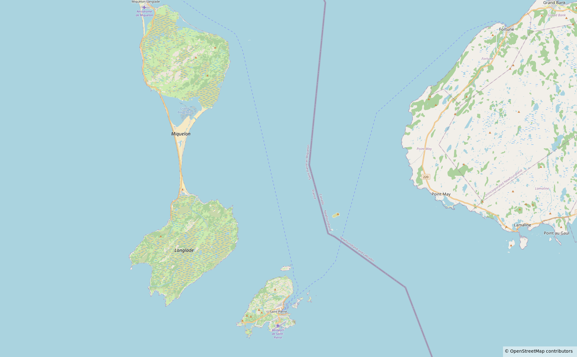
And then there's #Canada's land border with #France. Yes, really.
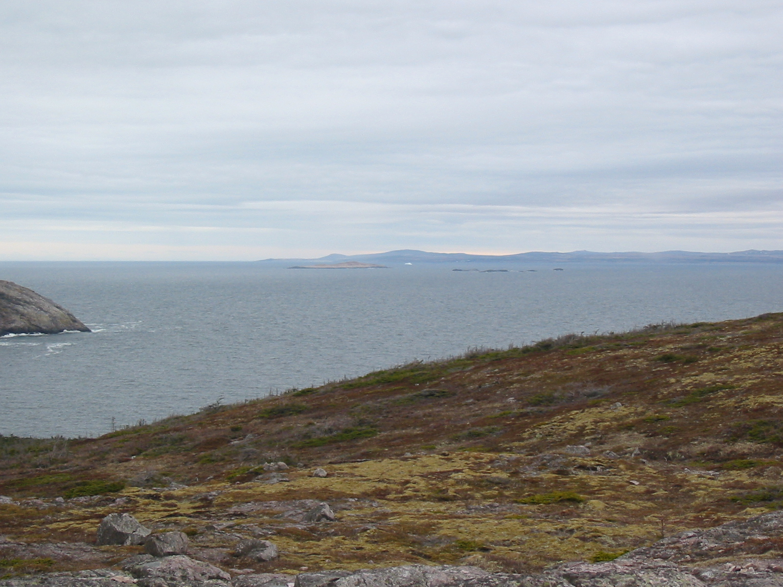
About 20 km off the coast of the Canadian island of Newfoundland is the French territory of Saint Pierre and Miquelon. The maritime boundary passes by a small uninhabited island called Green Island, but it manages to trample over one nearby tidal islet. At low tide, you could *very carefully* step along the forty or so metres of international border on this exposed rock.
So the answer would seem to be that Canada has land borders with three other countries: #USA, #Denmark and #France.
https://en.wikipedia.org/wiki/Green_Island_(Fortune),_Newfoundland_and_Labrador
(2/2)
How many other countries does #Canada have a land border with?
Obviously there's the #USA. The border between the USA and Canada is one of the longest in the world.
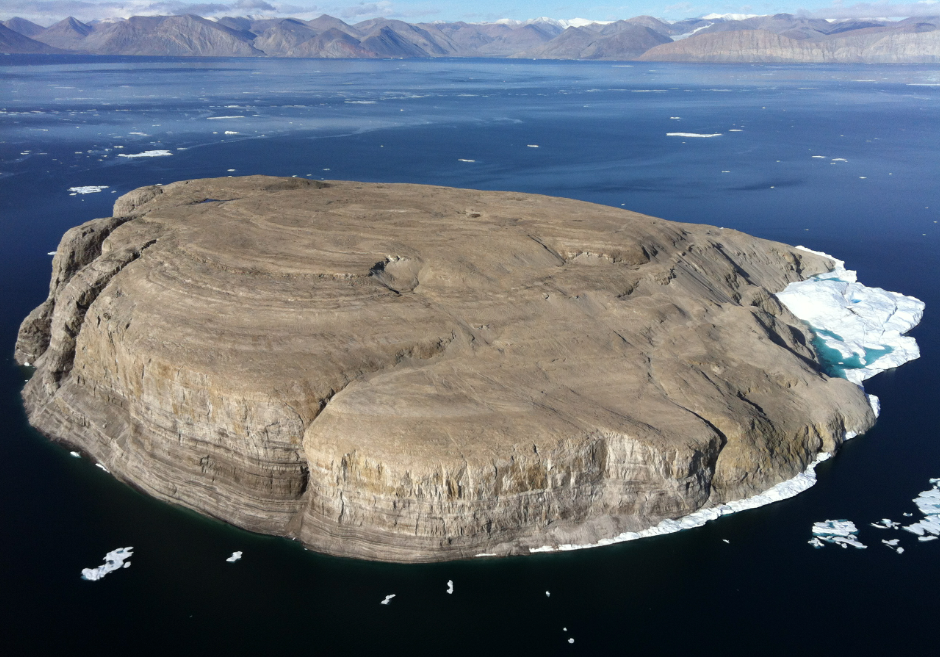
Since 2023, Canada has had a land border with #Denmark through the Danish territory of Greenland. Tartupaluk (Hans Island) straddles the maritime boundary between Ellesmere Island and Greenland. It was the subject of a friendly territorial dispute between the two countries, who finally agreed to share the island.
https://en.wikipedia.org/wiki/Hans_Island
(1/2)
A #GeoWeirdness challenge! I don't actually know the answer to this. Submissions and boosts welcome!
Sometimes two countries share a disjoint land border (e.g., Canada–USA; Spain–France; Russia–China).
What's the pair of countries where the land borders are the most distant from each other?
Conceptually, it isn't Spain–France because Andorra isn't that big. Canada–USA is about half the length of British Columbia, only I forgot about the Great Lakes being a long maritime border.
For more #GeoWeirdness fun, count how many international land borders Spain has. Also France.
A Canadian #GeoWeirdness quiz!
How many other countries does #Canada share a *land border* with?
If you reply, CW your response so you don't spoil the solution!
This week in #geoweirdness we close out our three part "Know your 'nesias" series.
In part I we looked at Micro/Poly/Melanesia
https://en.osm.town/@opencage/114313491471667657
Part II was the geographic oddities of Indonesia 🇮🇩
https://en.osm.town/@opencage/114443875625013997
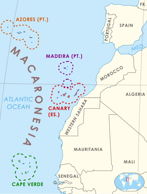
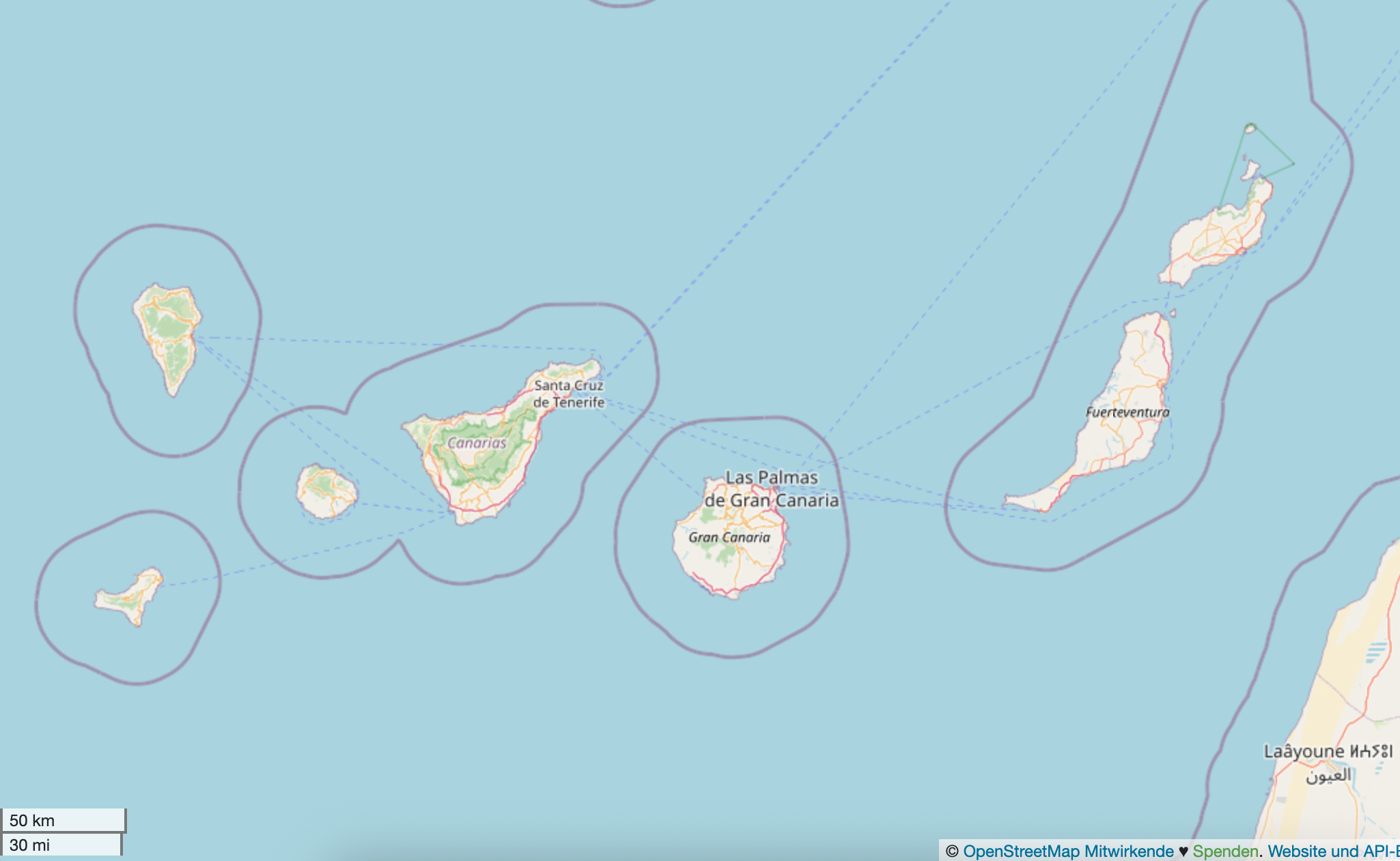
We turn our attention today to the less well-known Macaronesia, an Atlantic subregion which includes the Azores (🇵🇹), Madeira (🇵🇹), the Canary Islands (🇪🇸 🇮🇨) and Cabo Verde 🇨🇻.
1/
11/ And that brings an end not just to this thread on Macaronesia, but to all the Nesias! We hope you enjoyed this 3-part series. Thanks for reading and sharing. What geo oddities did we overlook?
Remember, this series as well as dozens more #geoweirdness threads are available on the OpenCage blog:
https://blog.opencagedata.com/geothreads
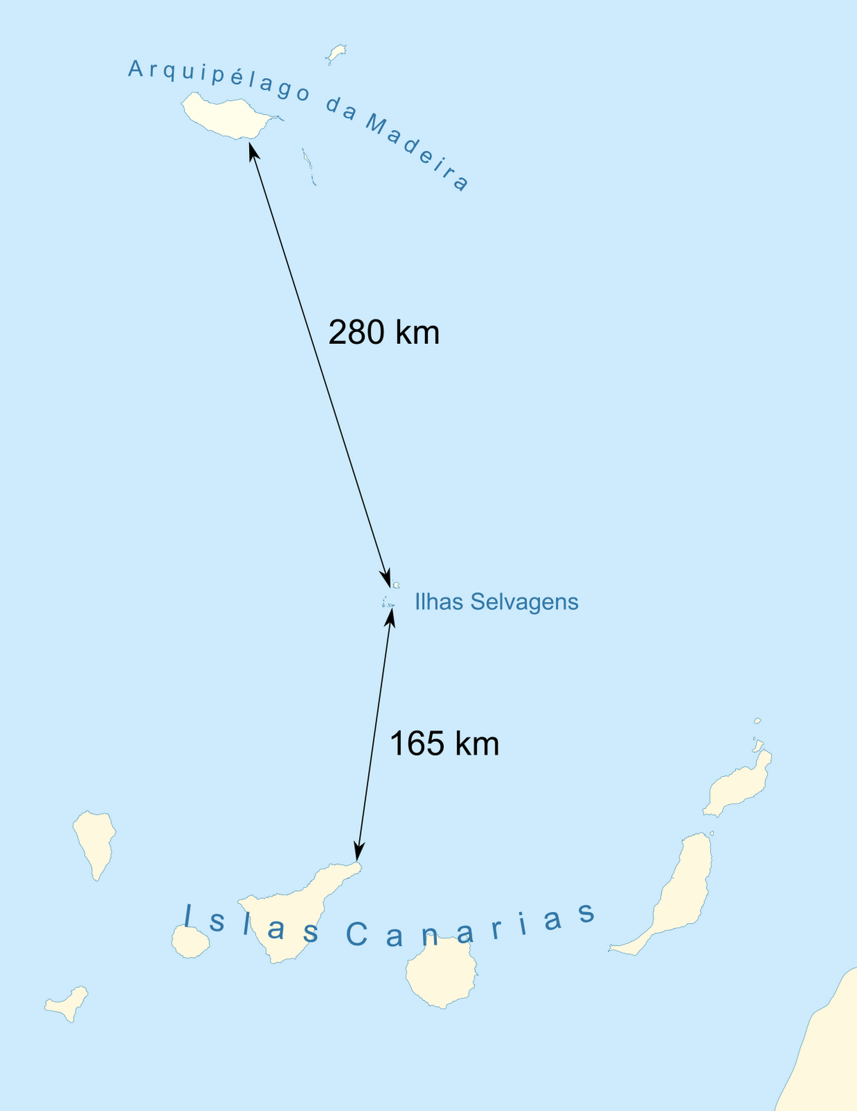
8/ Given the proximity to the Canaries, Spain 🇪🇸 has objected to Portugal's 🇵🇹 Exclusive Economic Zone around the Savage Islands.
The core of the dispute is whether these are islands or "rocks". According to article 121 of the United Nations Convention on the Law of the Sea: "Rocks which cannot sustain human habitation or economic life of their own shall have no exclusive economic zone or continental shelf.
https://en.wikipedia.org/wiki/Savage_Islands#Disputed_territory
10/ In 2013, the country formally known as Cape Verde officially changed its name to Cabo Verde 🇨🇻.
The move is seen as an assertion of national identity and was seen as an important milestone in the country’s history.
https://trendsdeeper.com/cape-verde-name-change-to-cabo-verde/
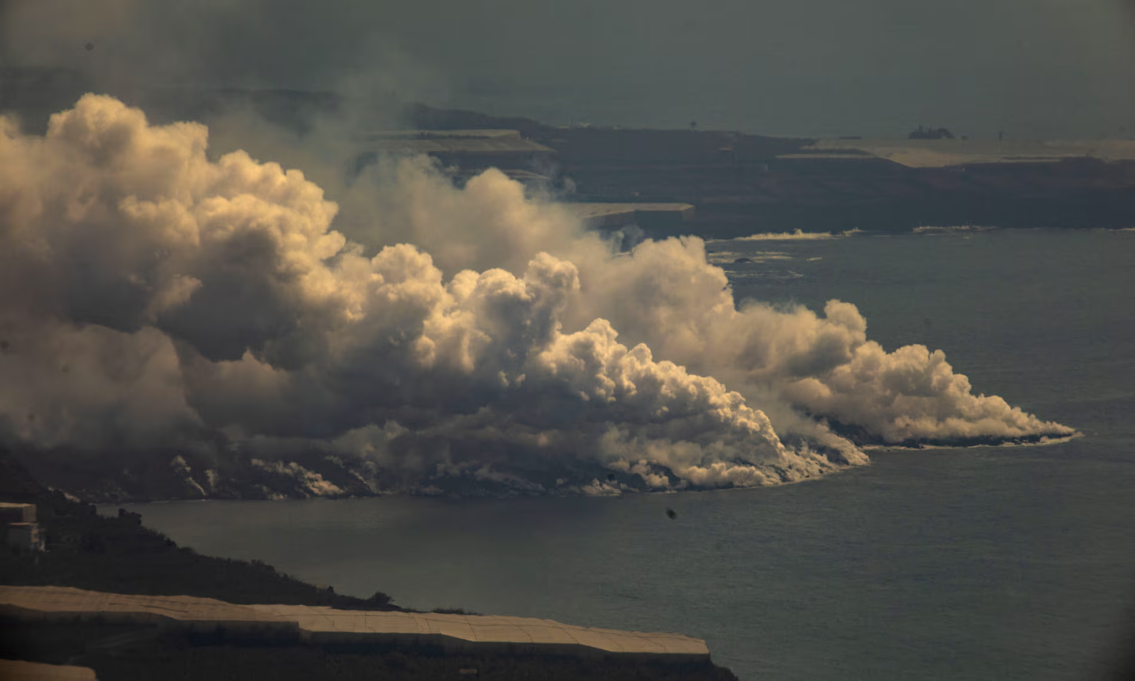
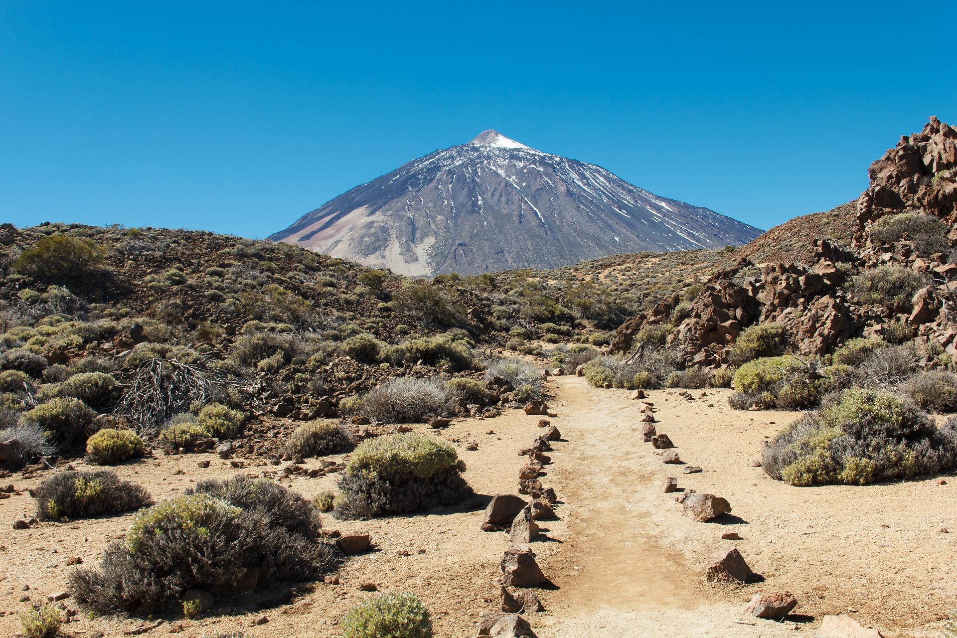
7/ While Teide formed roughly 170,000 years ago, there’s been some more recent volcanic activity in the Canary Islands that has caused some prime #geoweirdness
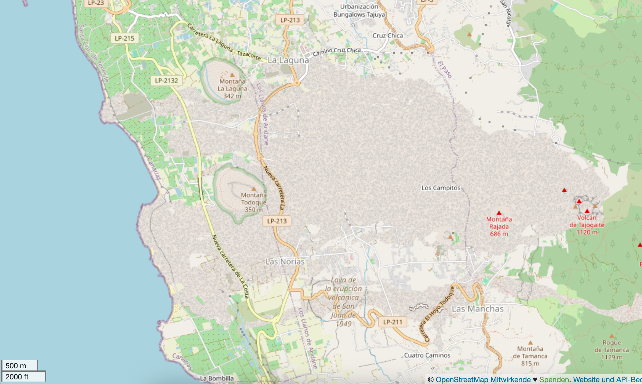
La Cumbre Vieja volcano erupted in 2021, causing lava to spew out, cool and form a 20-hectare large peninsula, increasing the size of La Palma island.
https://www.openstreetmap.org/?mlat=28.62515&mlon=-17.93316#map=14/28.62515/-17.93316
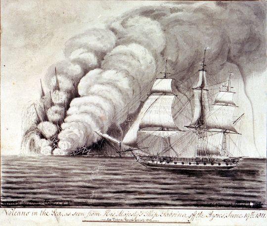
3/ Volcanic activity was the source of a bit of Azorean #geoweirdness - in 1811 a new island emerged, about 2km west of São Miguel (the largest island in the Azores).
The British 🇬🇧 ship HMS Sabrina happened to be in the area, landed on the newly named Sabrina Island, and claimed it for the UK. This lead to a a diplomatic dispute with Portugal 🇵🇹. The situation was resolved a few months later when the island eroded away.
6/ 400km south of Madeira, we have the Spanish 🇪🇸 Canary Islands which have their own ISO code: "IC" (and thus also own emoji flag: 🇮🇨
Like Mount Pico of the Azores, this non-continental region is home to the tallest peak in Spain, Mount Teide (3,715m above sea level). When taking into account the submerged part of the volcano, it’s 7,500 meters tall and the third-tallest volcano in the world.
I'll leave you with this great thread about #esc2025 along with a bit of #eurovision #eurovision2025 #geoweirdness ⤵️ https://en.osm.town/@opencage/114522432517661812
Are you ready for the most fabulous, glitzy, glamorous #geoweirdness thread of all time? 🕺💃🎤
Here in Europe there's only one thing on everyone's mind this week: the annual Eurovision Song contest. Let's consider the bizarre geographic aspects of this cultural phenomenon
https://eurovision.tv/event/basel-2025
1/

9/ Another controversy each year revolves around certain countries' participation.
Despite well-placed intentions to be a neutral, apolitical competition, the development of certain situations, for example, 🇷🇺 Russia’s invasion of Ukraine 🇺🇦 and 🇮🇱 Israel’s conflict 🇵🇸 Gaza, can cause considerable uproar about who is able to participate.
The following article outlines the debate very well:
https://www.theguardian.com/commentisfree/2025/may/16/israel-eurovision-gaza-european-broadcasting-union
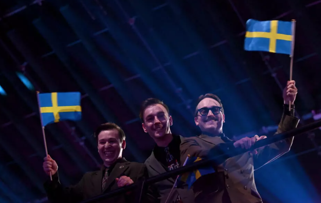
5/ One of the favorites this year is 🇸🇪Sweden’s representatives: KAJ, a comedic-musical group from the Swedish-speaking minority in Finland 🇫🇮
https://en.wikipedia.org/wiki/Swedish-speaking_population_of_Finland
Enjoy "Bara Bada Bastu" a rousing song about sauna
11/ That wraps up our look at the geographic oddness of #eurovision Thanks for reading and sharing. Enjoy the show - we can't predict who will win, but we can promise catchy tunes, weird costumes, and geo drama.
Here's a helpful party guide: https://www.missioneurovision.co.uk
For more #geoweirdness threads head over to our blog where they are all listed https://blog.opencagedata.com/geothreads
🕺💃🎶🪗🎤💃🪩🕺
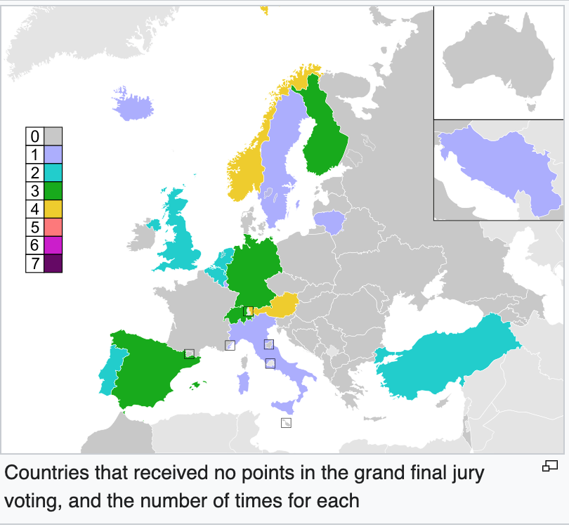
7/ Let's move on to the real source of #geoweirdness: voting.
As mentioned, points up for grabs range from 1-8, 10, 12. Much like statistic-heavy sports like cricket or baseball, Eurovision has it's own terminology. Until a change to the voting format in 2016, earning no points was referred to in delightful pseudo-French/English as having been awarded "nul points"
In 2015, Austria 🇦🇹 became the unlucky country to be the 1st host nation to receive “nul points”.
https://en.wikipedia.org/wiki/Voting_at_the_Eurovision_Song_Contest
6/ There are also interesting cases such as San Marino 🇸🇲.
Given their small population, they often select foreign performers, including artists from Italy 🇮🇹, Turkey 🇹🇷, and Germany 🇩🇪.
Unlike most countries' vote’s which are composed of 50% public televoting and 50% jury, San Marino doesn’t organise a televote.
This is because they share Italy’s phone network, and therefore, potential voters wouldn’t meet the threshold set by the EBU.
https://en.wikipedia.org/wiki/San_Marino_in_the_Eurovision_Song_Contest
Client Info
Server: https://mastodon.social
Version: 2025.04
Repository: https://github.com/cyevgeniy/lmst