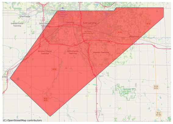
#EAS #WEA for Ingham, #MI: National Weather Service: #TORNADO WARNING in this area until 7:15 PM EDT. Take shelter now in a basement or an interior room on the lowest floor of a sturdy building. If you are outdoors, in a mobile home, or in a vehicle, move to the closest substantial shelter and protect yourself from flying debris. Check media. Source: NWS Grand Rapids MI #Ingham, #MIwx** DO NOT RELY ON THIS FEED FOR LIFE SAFETY, SEEK OUT OFFICIAL SOURCES ***
#Ingham
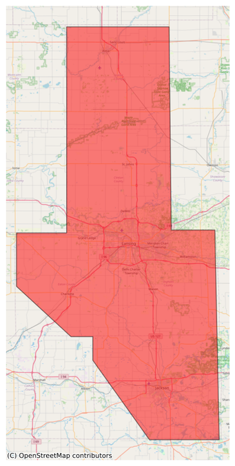
#EAS #WEA for Clinton, #MI; #Eaton, #MI; #Gratiot, #MI; #Ingham, #MI; #Jackson, #MI: National Weather Service: SEVERE THUNDERSTORM WARNING in effect for this area until 7:30 PM EDT for DESTRUCTIVE 80 mph winds. Take shelter in a sturdy building, away from windows. Flying debris may be deadly to those caught without shelter. Source: NWS Grand Rapids MI ** DO NOT RELY ON THIS FEED FOR LIFE SAFETY, SEEK OUT OFFICIAL SOURCES ***
#EAS #WEA for Clinton, #MI; #Eaton, #MI; #Gratiot, #MI; #Ingham, #MI; #Jackson, #MI: National Weather Service: SEVERE THUNDERSTORM WARNING in effect for this area until 7:30 PM EDT for DESTRUCTIVE 80 mph winds. Take shelter in a sturdy building, away from windows. Flying debris may be deadly to those caught without shelter. Source: NWS Grand Rapids MI #Clinton, #MI; #Eaton, #MI; #Gratiot, #MI; #Ingham, #MI; #Jackson, #MIwx** DO NOT RELY ON THIS FEED FOR LIFE SAFETY, SEEK OUT OFFICIAL SOURCES **
#EAS #WEA for Clinton, #MI; #Eaton, #MI; #Gratiot, #MI; #Ingham, #MI; #Jackson, #MI: Severe Thunderstorm Warning issued March 30 at 6:28PM EDT until March 30 at 7:30PM EDT by NWS Grand Rapids MI Source: NWS Grand Rapids MI #Clinton, #MI; #Eaton, #MI; #Gratiot, #MI; #Ingham, #MI; #Jackson, #MIwx** DO NOT RELY ON THIS FEED FOR LIFE SAFETY, SEEK OUT OFFICIAL SOURCES ***
#EAS #WEA for Eaton, #MI; #Ingham, #MI; #Jackson, #MI: National Weather Service: #TORNADO WARNING in this area until 6:45 PM EDT. Take shelter now in a basement or an interior room on the lowest floor of a sturdy building. If you are outdoors, in a mobile home, or in a vehicle, move to the closest substantial shelter and protect yourself from flying debris. Check media. Source: NWS Grand Rapids MI ** DO NOT RELY ON THIS FEED FOR LIFE SAFETY, SEEK OUT OFFICIAL SOURCES ***
#EAS #WEA for Eaton, #MI; #Ingham, #MI; #Jackson, #MI: National Weather Service: #TORNADO WARNING in this area until 6:45 PM EDT. Take shelter now in a basement or an interior room on the lowest floor of a sturdy building. If you are outdoors, in a mobile home, or in a vehicle, move to the closest substantial shelter and protect yourself from flying debris. Check media. Source: NWS Grand Rapids MI #Eaton, #MI; #Ingham, #MI; #Jackson, #MIwx** DO NOT RELY ON THIS FEED FOR LIFE SAFETY, SEEK OUT OF
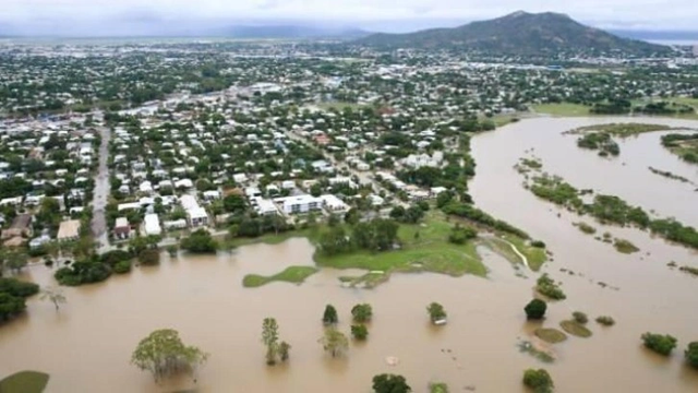
News Haber EshaHaber Şiddetli yağış Avustralya’yı vurdu!: Avustralya'nın kuzeyinde etkili olan şiddetli yağışlar nedeniyle Ingham kasabasında içinde bulunduğu teknenin alabora olması sonucu bir kadın hayatını kaybederken yükselen sel suları yerel havaalanı kapattı.
ŞİDDETLİ YAĞIŞ ÜLKENİN KUZEYİNİ ESİR ALDI!
Avustralya'nın kuzeyini şiddetli yağışlar vurdu. Queensland eyaletinin başkenti… https://www.eshahaber.com.tr/haber/siddetli-yagis-avustralya-yi-vurdu-201741.html?utm_source=dlvr.it&utm_medium=mastodon EshaHaber.com.tr #Avustralya #ŞiddetliYağış #SelFelaketi #Ingham #Brisbane
#EAS for Eaton, #MI; #Ingham, #MI: National Weather Service: #TORNADO WARNING in this area until 2:30 PM EDT. Take shelter now in a basement or an interior room on the lowest floor of a sturdy building. If you are outdoors, in a mobile home, or in a vehicle, move to the closest substantial shelter and protect yourself from flying debris. Check media. Source: NWS Grand Rapids MI** DO NOT RELY ON THIS FEED FOR LIFE SAFETY, SEEK OUT OFFICIAL SOURCES ***
#EAS for Eaton, #MI; #Ingham, #MI: National Weather Service: #TORNADO WARNING in this area until 2:30 PM EDT. Take shelter now in a basement or an interior room on the lowest floor of a sturdy building. If you are outdoors, in a mobile home, or in a vehicle, move to the closest substantial shelter and protect yourself from flying debris. Check media. Source: NWS Grand Rapids MI** DO NOT RELY ON THIS FEED FOR LIFE SAFETY, SEEK OUT OFFICIAL SOURCES ***
Details of Tropical #CycloneJasper at 4:00 pm AEST:
Intensity: category 2, sustained winds near the centre of 100 kilometres per hour with wind gusts to 140 kilometres per hour.
Location: within 55 kilometres of 16.9 degrees South, 153.7 degrees East , 880 kilometres east of #PortDouglas and 850 kilometres east of #Cairns .
Movement: southwest at 14 kilometres per hour .
Tropical Cyclone Jasper, category 2, is moving in a general westwards direction. Jasper is forecast to maintain intensity during Monday and Tuesday. Jasper is forecast to intensify to a category 3 cyclone shortly before making landfall during Wednesday, most likely between #Cooktown and #Cardwell.
Hazards:
#DamagingWinds of 90 km/h are expected to develop along the Queensland coast between #Cooktown and #Ingham, including #Cairns from Tuesday. DAMAGING WINDS of 90 km/hr may extend as far south as #Townsville or as far north as #CapeMelville depending on Jasper's exact movement.
#HeavyRainfall is expected to develop along the coast from late Tuesday.
As the cyclone approaches the coast, #AbnormallyHighTides are possible and large waves are likely along the coast.
Recommended Action:
People between Cape Melville and Townsville, including Cairns and Cooktown, should consider what action they will need to take if the cyclone threat increases.
- Information is available from your local government.
- For cyclone preparedness and safety advice, visit Queensland's Disaster Management Services website (www.disaster.qld.gov.au).
- For emergency assistance call the Queensland State Emergency Service (SES) on 132 500 (for assistance with storm damage, rising flood water, fallen trees on buildings or roof damage).


