#NCWx

Rand al'Thor 🏳‍🌈 :MTG_Card:rand__althor@kind.social
2025-06-23

Extended Weather Forecast: 23-29 June, 2025

youtu.be/Bi6_IU2Ekq8?feature=s

#wx #ncwx

Rand al'Thor 🏳‍🌈 :MTG_Card:rand__althor@kind.social
2025-06-23

Daily Weather Report: 23 June, 2025

youtu.be/iXH9YGfA7EE?feature=s

#ncwx #wx

NWS Newport/Morehead City Botnws_mhx@social.edist.ro
2025-06-23

MHX issues Area Forecast Discussion (AFD) at Jun 23, 7:31 AM EDT

mesonet.agron.iastate.edu/p.ph

#ncwx #wx

Edge 🇨🇦🇲🇽🇺🇦🏳️‍🌈czarbucks@vmst.io
2025-06-23

@BakerRL75

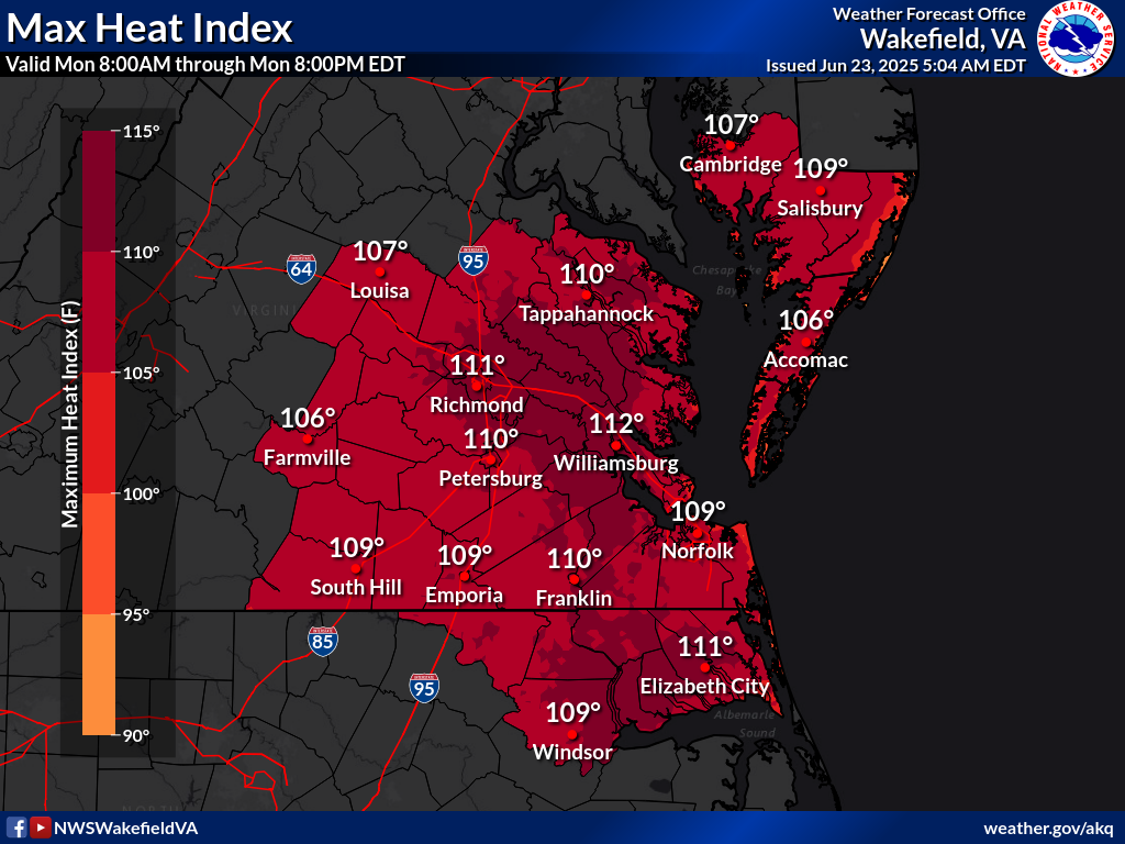
80F for the low? In NC? That's remarkable. I thought only FL was pushing those numbers.

#NCwx

2025-06-23

Boffins are having a heated debate regarding just which of Dante’s circles of hell we are in. Postcard forecast delayed.

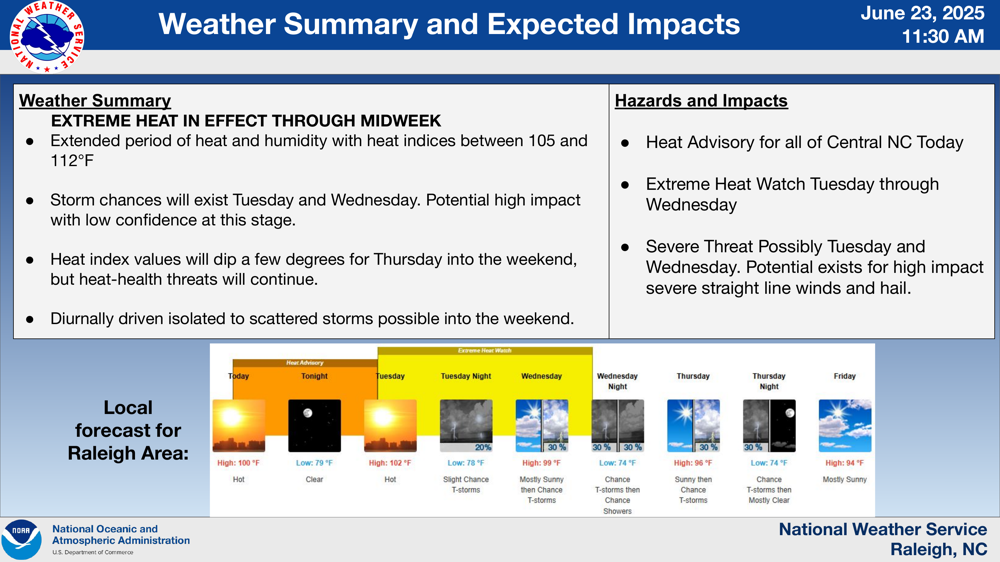
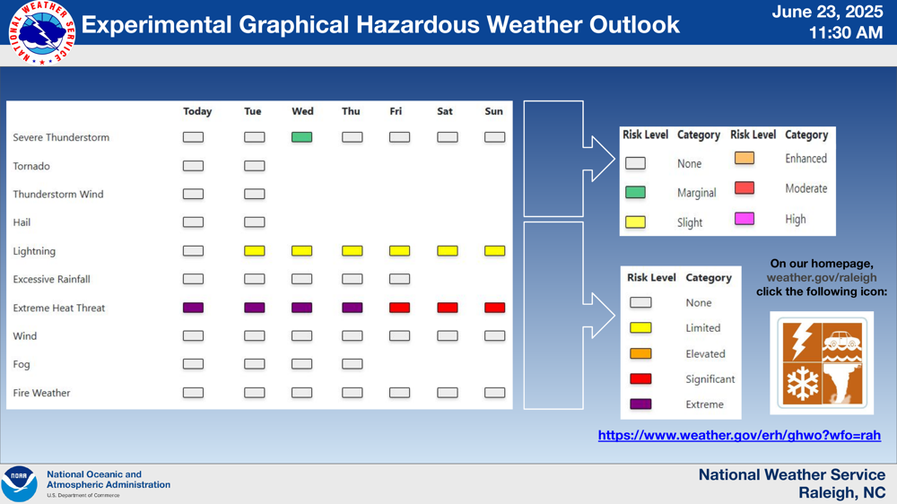
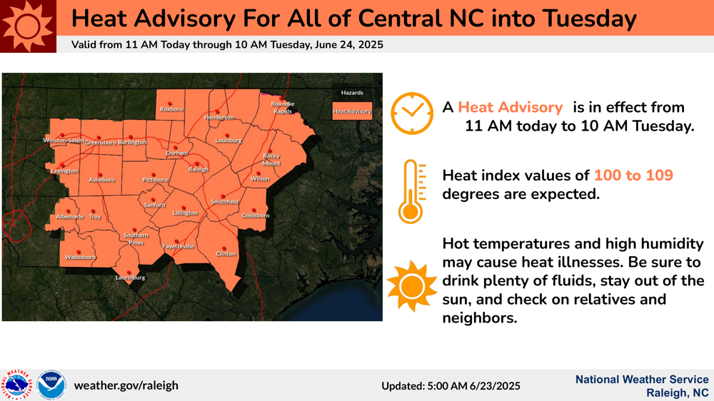
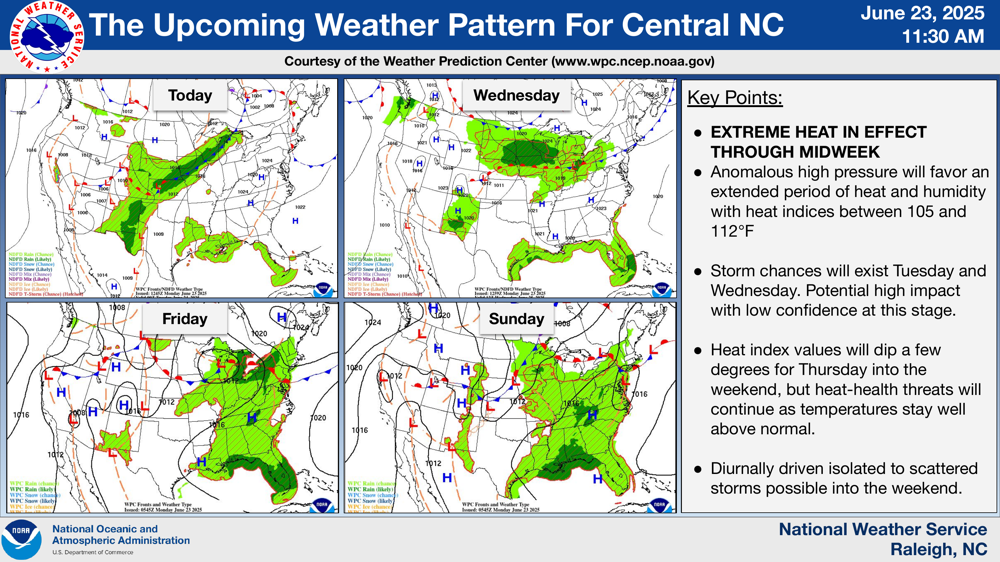
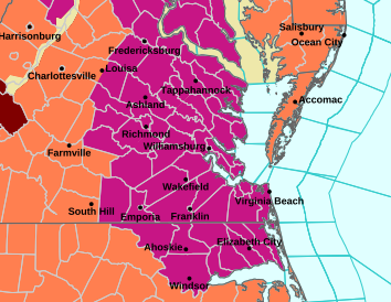
But WPC has generated a heat warning visual and boffins did get the hazard map updated.

DW made the discovery that it is possible to do garden care in the evening. It’s warm but still shade where the hells bells are to go. Sunday evening we managed a cool breeze.

#VAwx #NCwx #Circle_4

Today. Sunny, with a high near 95. Heat index values as high as 105. Southwest wind around 8 mph becoming northeast in the afternoon.

Tonight. Mostly clear, with a low around 79. Light and variable wind.

Tuesday. Sunny, with a high near 96. Heat index values as high as 106. Calm wind becoming northeast around 6 mph in the afternoon.

Tuesday Night. A slight chance of showers and thunderstorms before 2am. Mostly clear, with a low around 79. Southeast wind around 5 mph becoming calm in the evening. Chance of precipitation is 20%.216 AM EDT Mon Jun 23 2025

...EXTREME HEAT WARNING IN EFFECT FROM 10 AM THIS MORNING TO 8 PM EDT WEDNESDAY...

* WHAT...Dangerously hot conditions with heat index values up to 112 expected.

* WHERE...Bertie, Camden, Chowan, Gates, Hertford, Northampton, Pasquotank, Perquimans, and Western Currituck Counties.

* WHEN...From 10 AM this morning to 8 PM EDT Wednesday.

* IMPACTS...Heat related illnesses increase significantly during extreme heat and high humidity events.

PRECAUTIONARY/PREPAREDNESS ACTIONS...

Drink plenty of fluids, stay in an air-conditioned room, stay out of the sun, and check up on relatives and neighborsSPC does not include the mid-Atlantic states in the Day 1 discussion. 

But they have slathered us in pistachio green indicating isolated pop-up thunderstorms are possible. 

If steering currents are weak, storms will bulk up then drop their loads in place. These are the 6 inch per hour flash flooding givers!

Client Info

Server: https://mastodon.social
Version: 2025.04
Repository: https://github.com/cyevgeniy/lmst