MPX expires Cold Weather Advisory for 42 forecast zones in [MN] and Barron, Chippewa, Dunn, Eau Claire, Pepin, Pierce, Polk, Rusk, St. Croix [WI]
https://mesonet.agron.iastate.edu/vtec/f/2026-O-EXP-KMPX-CW-Y-0001_2026-01-19T17:47Z
MPX expires Cold Weather Advisory for 42 forecast zones in [MN] and Barron, Chippewa, Dunn, Eau Claire, Pepin, Pierce, Polk, Rusk, St. Croix [WI]
https://mesonet.agron.iastate.edu/vtec/f/2026-O-EXP-KMPX-CW-Y-0001_2026-01-19T17:47Z
MFR continues Air Stagnation Advisory for Eastern Curry County and Josephine County [OR] till Jan 21, 4:00 PM PST
https://mesonet.agron.iastate.edu/vtec/f/2026-O-CON-KMFR-AS-Y-0001_2026-01-19T17:47Z
MPX issues Area Forecast Discussion (AFD) at Jan 19, 11:21 AM CST
https://mesonet.agron.iastate.edu/p.php?pid=202601191721-KMPX-FXUS63-AFDMPX
The Storm Prediction Center issues Day 2 Convective Outlook at Jan 19, 17:06z
https://www.spc.noaa.gov/products/outlook/archive/2026/day2otlk_20260119_1730.html
Storm Prediction Center issues Mesoscale Discussion #28 concerning SNOW SQUALL
NHC issues Tropical Weather Discussion (TWD) at Jan 19, 6:15 PM UTC ...SPECIAL FEATURES...
https://mesonet.agron.iastate.edu/p.php?pid=202601191815-KNHC-AXNT20-TWDAT
The Storm Prediction Center issues Day 1 Fire Weather Outlook at Jan 19, 16:36z
https://www.spc.noaa.gov/products/fire_wx/2026/260119_1700_fwdy1_print.html
MPX issues Public Information Statement (PNS) at Jan 19, 9:55 AM CST ...MINIMUM WIND CHILL REPORTS...
https://mesonet.agron.iastate.edu/p.php?pid=202601191555-KMPX-NOUS43-PNSMPX
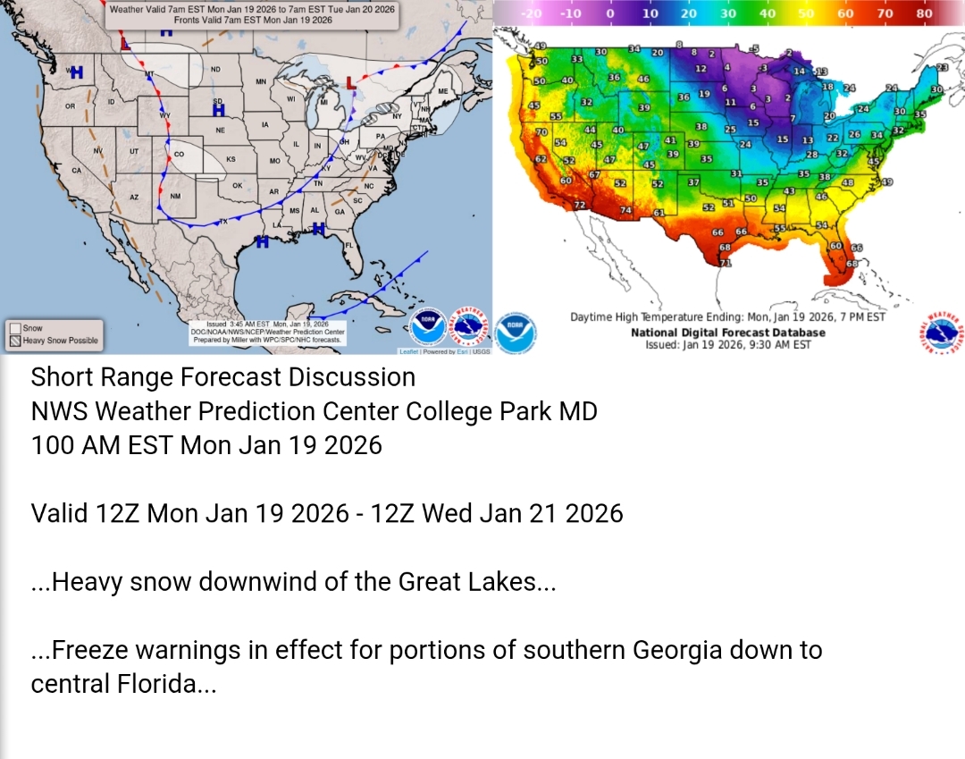
Here's today's forecast map and today's high temperature map. Check out the NWS site for more National Forecast Maps www.weather.gov/forecastmaps #weather #wx #TheOutPost #Forecast #precipitation #Temperature
Thunderstorms are not expected across the U.S. today or tonight. #WeatherAwareDay #weather #wx #SPC #TheOutpost #SevereWeather #categorical #tornado #wind #hail Additional info in alt text.

Thunderstorms are not expected across the U.S. today or tonight.
#WeatherAwareDay #weather #wx #SPC #SevereWeather #categorical #tornado #wind #hail
Additional info in alt text.

Here's today's forecast map and today's high temperature map. Check out the NWS site for more National Forecast Maps https://www.weather.gov/forecastmaps
#weather #wx #Forecast #precipitation #Temperature

Thunderstorms are not expected across the U.S. today or tonight.
#WeatherAwareDay #weather #wx #SPC #SevereWeather #categorical #tornado #wind #hail
Lake-effect Snow and Whiteout Conditions in the Great Lakes Region; Below-average Temperatures in the East
Heavy lake-effect and lake-enhanced snow will persist downwind of the Great Lakes and produce some whiteout conditions that could cause difficult travel conditions. A coastal low will produce moderate to heavy snow over parts of southern and eastern New England into the afternoon. Below average temperatures are expected across the eastern U.S., particularly with chilly morning temperatures

Here's today's forecast map and today's high temperature map. Check out the NWS site for more National Forecast Maps https://www.weather.gov/forecastmaps
#weather #wx #Forecast #precipitation #Temperature