Salt Tectonics
Salt tectonics is the study of significant thicknesses of rock salt within sedimentary basins, how and why salt structures evolve and the three-dimensional forms that result, and the physics of salt mobilization. Salt tectonics is a fascinating branch of geology in itself. A good place to start with salt tectonics is geologist Myron Cook’s video linked below. It is 25 minutes long, but it’s an easy and fun watch. I recommend it. I have recapped it below. Bonus: Look at Myron Cook’s kitchen countertops. They are some kind of conglomerate, and I have a feeling it’s the Mineral Fork tillite. Why is that exciting? See: https://c.im/@vickyveritas/109583699008268157
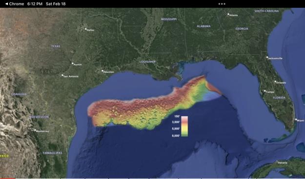
Myron Cook opens the video with a map of the Sigsbee escarpment bathymetry map that shows the water depth from light pink = 150’ to dark green = 800’ (see below). This feature lies in the Gulf of Mexico offshore of Texas and Louisiana and is 550 miles in length. A close-up look shows the pitted surface of the escarpment that -spoiler alert- is underlain by salt deposits, but how did the salt get there?
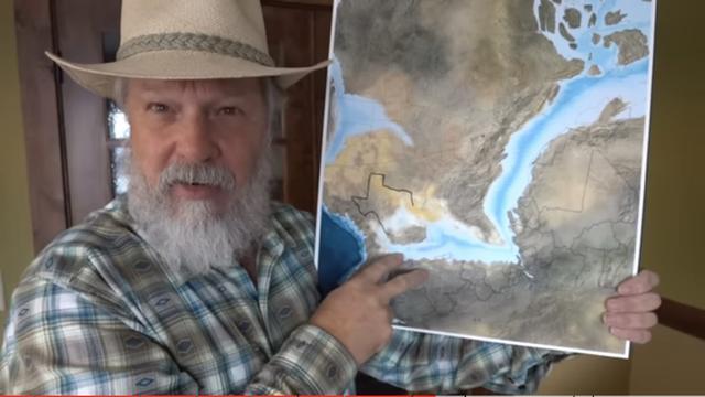
170 million years ago, the supercontinent Pangaea started to rift apart where the Gulf of Mexico is now, opening a narrow and restrictive seaway allowing the water to evaporate whilst it still was being replenished (see below). This allowed the salt in the seawater to become very concentrated and it began to precipitate and drop to the ocean floor. Over deep time (a million years), the salt depositional body, called the “mother salt,” grew to 4,000 feet thick, and on land, erosion from the Rocky Mountains and from rifting began to deposit sediments on top of the salt body.
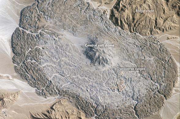
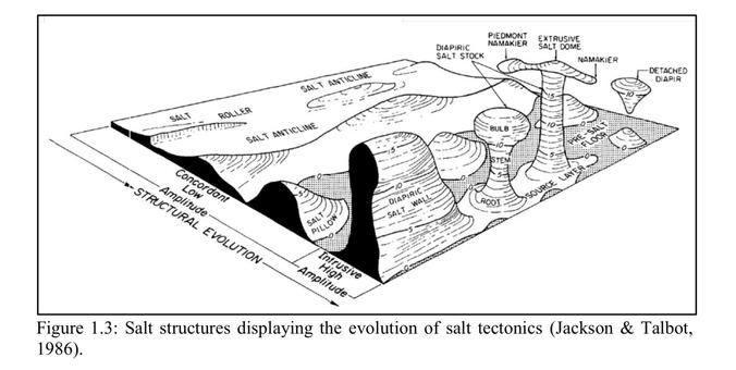
Sediments usually have a lower density than halite (salt), but after continuous loading sediment increases its density to greater than that of the halite, and that’s when salt tectonics begins. The underlying principle of salt tectonics is that salt moves from zones of higher load to zones of lower load, and the salt begins to flow, squishing and squeezing through fractures in rock, forcing its way vertically and horizontally forming 3D structures such as salt anticlines, ridges and walls, stocks, nappes, pillows, rollers, diapirs, detached diapirs, diapiric walls, extrusive domes (see below), and salt glaciers! Below is an ISS image of an oval-shaped salt glacier, about 14 km (8 mi) across, in the Zagros Mountains, Iran!
Salt bodies like the one just described can dome up causing faulting, and deflate causing subsidence and faulting. Imagine if you lived where there was a large salt body like there is in the Houston area, and it, along with all the associated growth faults (faults that form where there are large evaporate (ie salt) deposits), and groundwater and oil extraction has caused surface disruptions. See articles below for maps and details.
Finally, I posted on Upheaval Dome, Utah last week https://c.im/@vickyveritas/109876309686729772 , a feature that has been hypothesized to be caused by a salt diapir that later eroded away, or by a meteorite impact. There are salt bodies in the area, and knowing how powerful salt can be, this is likely the cause of that enigmatic feature.
Myron Cook’s video, A Gigantic and Mysterious Feature that Nobody has Heard of: https://youtu.be/y2Qqslr5ytY
More on Houston area problems: https://www.researchgate.net/publication/277003791_Growth_Faulting_and_Subsidence_in_the_Houston_Texas_Area_Guide_to_the_Origins_Relationships_Hazards_Potential_Impacts_and_Methods_of_Investigation
And more including maps: https://uh-ir.tdl.org/bitstream/handle/10657/636/Zheng%20Huang%20MS%20Thesis%20Geology.pdf?sequence=1
A tip of the hat to @rock_jockey who provided the inspiration for this post.
#SaltTectonics #Salt #Halite #SaltStructures #SaltGlacier #Houston #UpheavalDome #geology #Science


