#BridgeFire #UTwx
2/2
Values at risk in this incident include areas of cultural significance, the communities of Rainbow City and Navajo Mountain to the south and east, and the communications towers on top of Navajo Mountain. Firefighting personnel are divided into two groups. Tower Group is focusing on scouting and identifying work to be done on the mountain nearest the fire while Structure Group is establishing defensible space around values once they’ve been identified. Direct attack on the fire is not being undertaken due to potential damage to the land and risks to firefighters posed by extreme terrain, difficult roads, high winds, challenging communications, and lengthy extraction times should injury occur. Some aspects of the situation are working in favor of suppression efforts including large rocky areas and former burn scars slowing the fire’s progress. The probability of successful defense of the values at risk is high.
#BridgeFire
#NIFC #wildfires #firewx
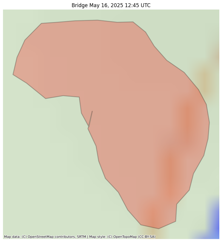
NIFC New Or Updated Wildfire Perimeter
Incident Name: Bridge
Acres: 0.2 acres
Updated: May 16, 2025 12:45 UTC
Source: IRWIN
#BridgeFire #WIwx

#NIFC #wildfires #firewx
NIFC New Or Updated Wildfire Perimeter
Incident Name: Bridge
Acres: 0.2 acres
Updated: May 16, 2025 12:45 UTC
Source: IRWIN
#BridgeFire #WIwx

#NIFC #wildfires #firewx
NIFC New Or Updated Wildfire Perimeter
Incident Name: Bridge
Acres: 0.2 acres
Updated: May 16, 2025 12:45 UTC
Source: IRWIN
#BridgeFire #WIwx
#NIFC #wildfires #firewx
NIFC New Or Updated Wildfire Perimeter
Incident Name: Bridge
Acres: 0.2 acres
Updated: May 16, 2025 12:45 UTC
Source: IRWIN
#BridgeFire #WIwx

#NIFC #wildfires #firewx
NIFC New Or Updated Wildfire Perimeter
Incident Name: Bridge
Acres: 0.2 acres
Updated: May 16, 2025 12:45 UTC
Source: IRWIN
#BridgeFire #WIwx

#NIFC #wildfires #firewx
NIFC New Or Updated Wildfire Perimeter
Incident Name: Bridge
Acres: 0.2 acres
Updated: May 16, 2025 12:45 UTC
Source: IRWIN
#BridgeFire #WIwx

#NIFC #wildfires #firewx
NIFC New Or Updated Wildfire Perimeter
Incident Name: Bridge
Acres: 0.2 acres
Updated: May 16, 2025 12:45 UTC
Source: IRWIN
#BridgeFire #WIwx

#NIFC #wildfires #firewx
NIFC New Or Updated Wildfire Perimeter
Incident Name: Bridge
Acres: 0.2 acres
Updated: May 16, 2025 12:45 UTC
Source: IRWIN
#BridgeFire #WIwx

#NIFC #wildfires #firewx
NIFC New Or Updated Wildfire Perimeter
Incident Name: Bridge
Acres: 0.2 acres
Updated: May 16, 2025 12:45 UTC
Source: IRWIN
#BridgeFire #WIwx

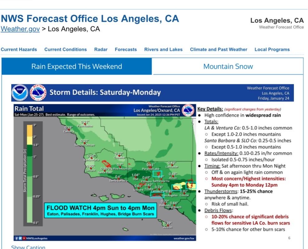
Los Angeles County has just issued Evacuation Warnings for the #FranklinFire #PalisadesFire #EatonFire and #BridgeFire burn scars due to the incoming atmospheric river. Evacuations are posted on Genasys. https://protect.genasys.com/search?z=10.944016549594256&latlon=34.10860153054726%2C-118.57288901277775 #wildfires #evacuation #LosAngelesCounty #CAwx #rain
Head's up on possible burn scar flooding. #EatonFire #FranklinFire #PalisadesFire #HughesFire #BridgeFire #Malibu #PacificPalisades #Altadena #Pasadena
NWS Los Angeles/Oxnard Forecast for Sat-Mon (Jan 25-27)
FLOOD WATCH 4pm Sun to 4pm Mon Eaton, Palisades, Franklin, Hughes, Bridge Burn Scars
#CAwx #EatonFire #PalisadesFire #FranklinFire #HughesFire #BridgeFire
LA Times: The feds closed Mt. Baldy to hiking until December 2025. Rebellion is brewing https://www.latimes.com/california/story/2024-12-18/the-feds-closed-mt-baldy-to-hiking-until-december-2025-rebellion-is-brewing #hiking #MtBaldy #wildfires #BridgeFire
#NIFC #wildfires #firewx
NIFC New Or Updated Wildfire Perimeter
Incident Name: BRIDGE
Acres: 56022.3 acres
Updated: Oct 30, 2024 20:00 UTC
Source: IRWIN
#BRIDGEFire #CAwx
#NIFC #wildfires #firewx
NIFC New Or Updated Wildfire Perimeter
Incident Name: BRIDGE
Acres: 56022.3 acres
Updated: Oct 30, 2024 20:00 UTC
Source: IRWIN
#BRIDGEFire #CAwx
The #BridgeFire continues to flare up, the Dalton Wilderness Park and various canyons filled with smoke this morning again :( The area is to be closed until the end of this year