
The eyewall of Severe Tropical Cyclone #Fina is striking the remote #Kimberley east coast about 120 km north of Wyndham, Western Australia. Seen by GEO-KOMPSAT #CycloneFina
#CycloneFina
Severe Tropical Cyclone #Fina 🌀edging across the west of Bonaparte Gulf towards remote landfall in Western Australia seen by #Himawari-9 🛰️ #CycloneFina

Northern Territory #Australia > Severe Tropical #CycloneFina has intensified into a category 4 system moving south-west towards the north-east Kimberley coast.
Current: 1.31 pm ACST Sunday 23 November 2025
Latest Track Map > https://www.bom.gov.au/warning/tropical-cyclone-forecast-track-map/IDD65011


Is there a fan club yet for the quiff on the BoM guy's head?
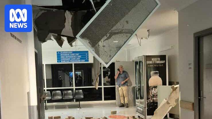
appearing on #abc #CycloneFina
Tropical Cyclone #Fina 🌀passage past the Tiwi Islands and #Darwin, Northern Territory, Australia, (0000 UTC 21 to 2150 UTC 22 Nov ~46 hour loop using GEO-KOMPSAT🛰️ infrared images) #CycloneFina #tropicalcyclonefina

Severe Tropical Cyclone Fina moves towards WA as Darwin wakes to survey the damage
Severe Tropical Cyclone Fina has passed Darwin as a category three, with the weather system’s gale-force winds leaving…
#NewsBeep #News #Headlines #AU #Australia #BOM #BureauOfMeteorology #CapeHotham #cyclone #cyclonedamage #CycloneFina #cyclonent #damagefromcyclone #darwin #Fina #northernterritory #nt #ntcyclone #severetropicalcyclonefina #tropicalcyclone #TropicalCycloneFinA
https://www.newsbeep.com/266554/

#ABCNews #Australia screenshot from the 7pm #Victorian news covering #cyclonefina.
What appears to be a #turtle #shell in a skip full of rubbish.


This is getting bigger. I was in Darwin for Cyclone Marcus in 2018. It was Cat 2 and did a lot of damage. This one is 3. Neighbour at the time said the cyclones at the edge of the season tend to be the worst (this one's early, Marcus was late). But then again Tracy was at the height of the season and it was exceptionally severe.
#CycloneFina
https://www.abc.net.au/news/2025-11-22/tropical-cyclone-fina-live-blog-saturday-november-22/106038950

Latest projections from BOM ACCESS-C and ECMWF HRES for Severe Tropical #CycloneFina. Both already a little off the mark; ACCESS closer. Official forecast track at https://www.bom.gov.au/warning/tropical-cyclone-forecast-track-map/IDD65011.
Comparison between projections from ECMWF HRES and BOM ACCESS-G for Tropical #CycloneFina. Official forecast track at https://www.bom.gov.au/warning/tropical-cyclone-forecast-track-map/IDD65011.
Convection associated with Tropical #CycloneFina. The system may be over Van Diemen Gulf, north east of Darwin, by Saturday. https://www.bom.gov.au/warning/tropical-cyclone-forecast-track-map/IDD65011
#Australia #CycloneFina > Tropical Cyclone Fina has formed north of Darwin and is moving slowly to the east north-east away from the coast.
Current: 4:11 am CST Wednesday 19 November 2025.
Latest Track Map: https://www.bom.gov.au/warning/tropical-cyclone-forecast-track-map/IDD65011
Client Info
Server: https://mastodon.social
Version: 2025.07
Repository: https://github.com/cyevgeniy/lmst