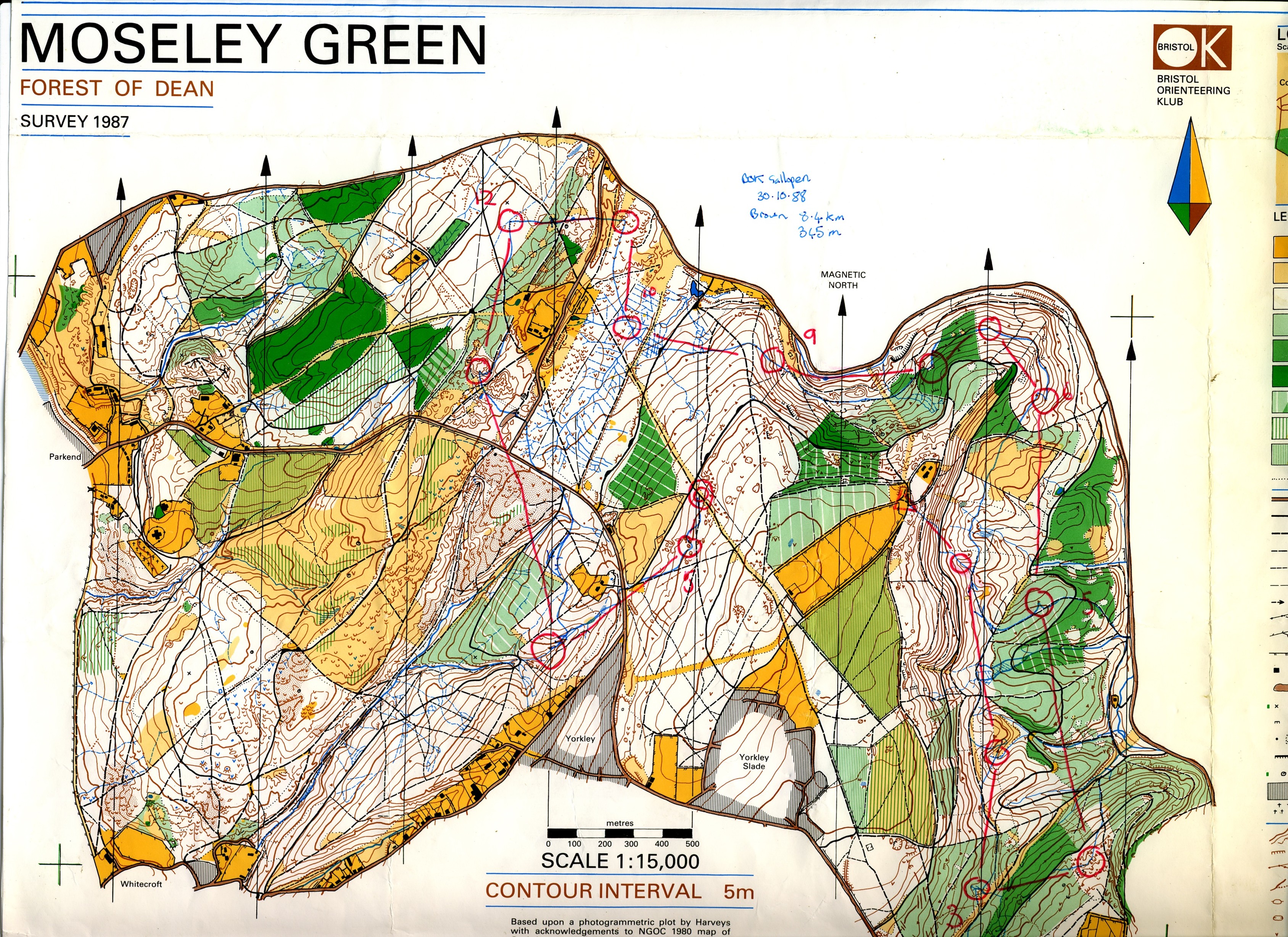
Moseley Green 1988 #BOK #ForestOfDean. The eastern part was covered by the 1973 Oakenhill Wood map of variable scale infamy. #OldOrienteeringMaps #OMaps #Orienteering
#OMaps
Wharncliffe 1978
#JK individual with M17 course. Lots of rock features in an area often wheeled out by #SYO for big events. #OldOrienteeringMaps #OMaps #Orienteering
2022 version:
www.syo.routegadget.co.uk/rg2/#233
www.geograph.org.uk/photo/3813501
Happendon Wood 🎨 Harvey Map Service 1978. This map was often displayed by Harveys at events and is beautifully scribed. Since use, the M74 was built through the area and the Douglas (west) part of the area fell out of use. Happendon is still used.
#Lanarkshire #OldOrienteeringMaps #OMaps #OrienteeringMap
Newcastleton Forest. F Jolly and Heriot-Watt University Orienteering Club 1980. HWUOC liked Sitka plantations, they mapped Blairadam a year later - I would love to see that map.
Newcastleton has had some changes since - the yellow was planted with trees soon after the event and there is a #7Stanes trail centre there now. #OldOrienteeringMaps #OMaps #Orienteering #MTB
Drumore Wood 1975 - a bit of surviving rainforest in the midst of the Loch Ard Forest, Aberfoyle. Physical!
#OldOrienteeringMaps #OMaps
Corstorphine Hill 1978
#OldOrienteeringMaps #Omaps #EUOC #Edinburgh
@esocweb
It's #Scottish6Days Week, so here is Culbin from the World Championships in 1976 and the first ever 6 Days. #Orienteering #OldOrienteeringMaps #OMaps
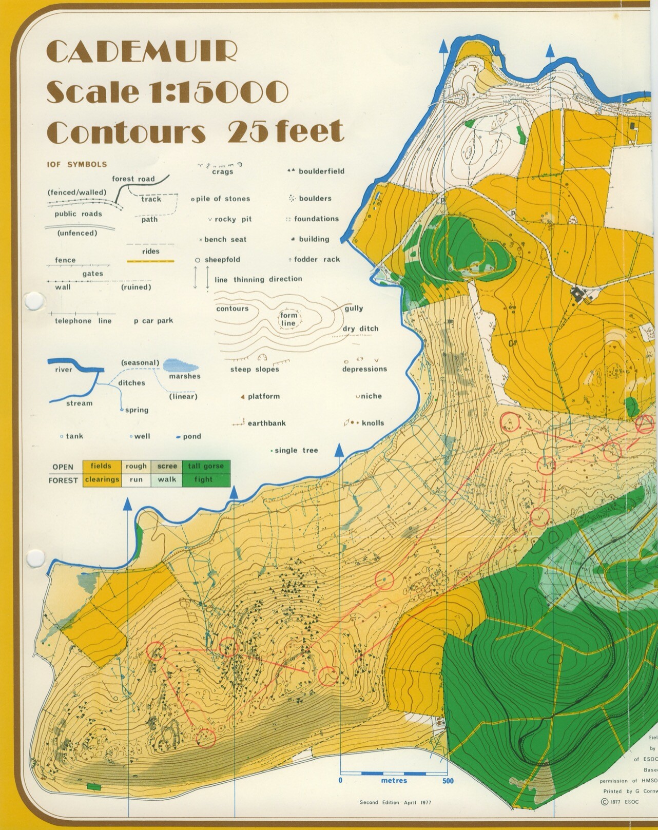
Cademuir 1977
Includes South Park (and tunnel)
#OldOrienteeringMaps #Omaps #ESOC #Peebles
Archerfield Wood - felled to make way for golf courses, one of which has been used for the #ScottishOpen this weekend. The big yellow area is Muirfield. Despite the loss of much of the area, it hosted the 2017 Scottish Championships. #OldOrienteeringMaps #Omaps.
Pollok Park 1979 - mixing it up with the Heilans and no Burrell. #OldOrienteeringMaps #Omaps #Glasgow
Penninghame 1991 - Sitka Hell by Newton Stewart, I visited the trig pillar/bagged the TuMP on the map last year and it was a struggle. 1991 6 days. I expect some of it a generation on now. #OldOrienteeringMaps #OMaps #Galloway
Rock Coppice 1979. One of those events I had to cycle to, got a lift back with Bishop's Castle High School. A lost area, now a sea of nasty keep out signs. A fragment of the Wyre Forest - very brambly. #OldOrienteeringMaps #OMaps
Fernworthy 1979. What would this look like in the Lidar era. These were 10m interval. This was the JK individual - just one day then followed by a relay and an informal race on the Monday. Longer courses went out on the moors for spectator controls.
#OldOrienteeringMaps #OMaps
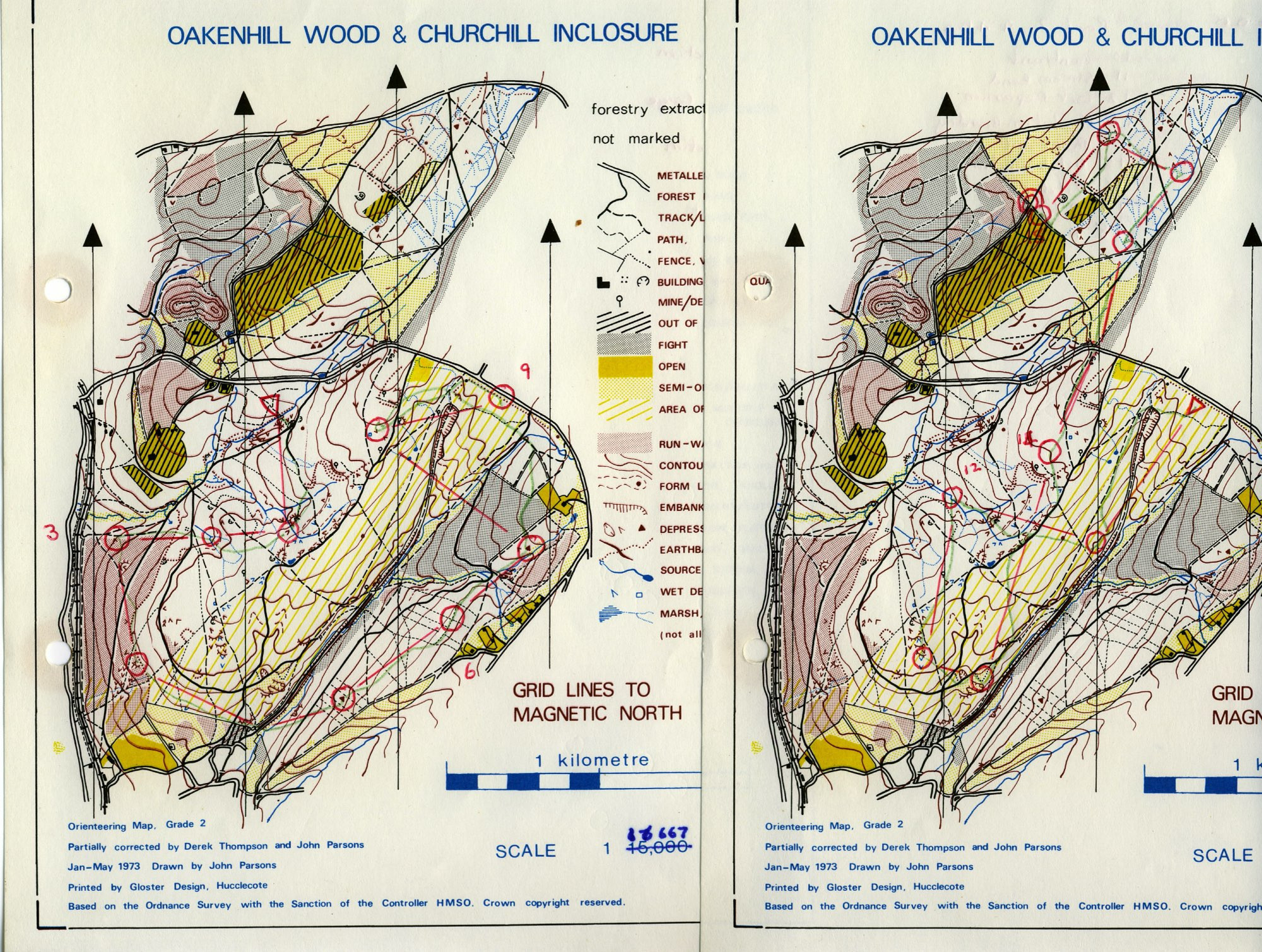
Oakenhill Wood and Churchill Inclosure 1973 with later revisions. A 1978 event, probably a NGOC Saturday event
#OldOrienteeringMaps #OMaps #ForestOfDean
Ogof Ffynnon Ddu Peter Seaward 1978. The legendary gritstone maze in the Swansea Valley. Event held in thick fog which lifted in time to help somebody beat me. #OldOrienteeringMaps #OMaps
Beechenhurst 1974-78 The anomalous club badge stands out in this very much
BristolOK
area. This is an update of the 1974 JK maps and as now it was a regular on the fixture list. #ForestOfDean #OldOrienteeringMaps #OMaps
Bannerdown 1976 P. Fielding and J Metcalfe. Schools were very active in putting on #orienteeringevents in the 1970s with Millfield and Kingswood adding to the fixture lists in #Somerset. This wood is just outside Bath. #OldOrienteeringMaps #OMaps
The Sidelands, Mike Nelson 1977
Somerset limestone terrain, no need for a blue register. Now a small part of a larger Tyntesfield map. One of the smallest maps I have ever used.
"Corstorphin Woods" D Bruce and G Barnett, Heriot Watt 1972. #OldOrienteeringMaps #Edinburgh #OMaps
#Orienteering was very popular in the 1970s and almost every University was active.
As for the spelling - did they run out of room?
Time for another map from the last days when five colours was a big deal. Soudley Ponds, 1978. The event was moved from Feb to May after a big snowfall (I was snowed in for 4 days, a big deal for the Somerset Levels.) Course is M17A
#OldOrienteeringMaps #OMaps #ForestOfDean
Client Info
Server: https://mastodon.social
Version: 2025.04
Repository: https://github.com/cyevgeniy/lmst