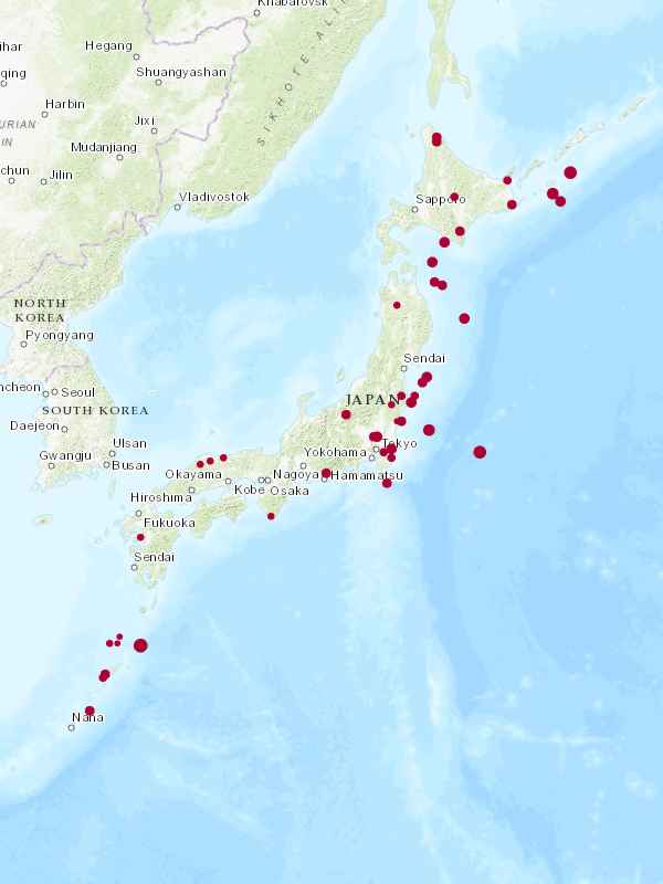
Weekly Quake Report
Reported Quakes: 50
#EarthQuake #Quake #Japan
#Quake
Daily Quakes
■■■□□□□□□□
■■■■□□□□□□
■■■■□□□□□□
■■■■□□□□□□
■■■■■□□□□□
■■■□□□□□□□
■■■□□□□□□□
#EarthQuake #Quake
Magnitude: 2.5 Intensity: 1 Depth: 10000m
■■■□□□□□□□
Details: 2026-02-12 JST 13:05:50
Location: 秋田県内陸北部 (Northern Inland of Akita Prefecture)
Map: https://www.google.com/maps/place/40°120%20N+140°3559%20E/@40.2,140.6,10z
#EarthQuake #Quake #Japan

Magnitude: 3.4 Intensity: 1 Depth: 80000m
■■■□□□□□□□
Details: 2026-02-12 JST 07:39:45
Location: 福島県中通り (Nakadori, Fukushima Prefecture)
Map: https://www.google.com/maps/place/37°2359%20N+140°480%20E/@37.4,140.8,10z
#EarthQuake #Quake #Japan

Magnitude: 5.2 Intensity: 3 Depth: 60000m
■■■■■□□□□□
Details: 2026-02-12 JST 03:00:52
Location: 北海道東方沖 (Off the east Coast of Hokkaido)
Map: https://www.google.com/maps/place/44°60%20N+147°300%20E/@44.1,147.5,10z
#EarthQuake #Quake #Japan


Author(s): Chuma
Title: Chuma's experimental archives Vol. 1
Experimental and testing maps
https://www.slipseer.com/index.php?resources/chumas-experimental-archives-vol-1.354/updates
#archival #archive #doom #joke #speedrunning #testing #voreball #vores #slipseer #quake
Title: Chuma's experimental archives Vol. 1
Experimental and testing maps
https://www.slipseer.com/index.php?resources/chumas-experimental-archives-vol-1.354/updates
#archival #archive #doom #joke #speedrunning #testing #voreball #vores #slipseer #quake

Magnitude: 4.3 Intensity: 3 Depth: 60000m
■■■■□□□□□□
Details: 2026-02-12 JST 02:28:35
Location: 青森県東方沖 (Off the east Coast of Aomori Prefecture)
Population of Aomori-ken: 1180000
Map: https://www.google.com/maps/place/41°300%20N+142°00%20E/@41.5,142.0,10z
#EarthQuake #Quake #Japan

Title: Under A Stone Blanket
Author(s): Brendy Caldwell
Date: 2022-03-01
Small tomb / crypt brick map built within a 1024^3 volume, textured with Makkon and based on Progs_dump (included). Map source is included.
https://www.quaddicted.com/db/v2/maps/02f951e263ff7695e93b7022a2449ae1a0c313a61c5d36383bebad66a2277f91
#brick #stone #tomb #mod #quake


[Перевод] Компилируем Quake, как будто на дворе 1997 год
Первые исполняемые файлы Quake ( quake.exe и vquake.exe ) программировали на HP 712-60 с NeXT и кросс-компилировали при помощи DJGPP, запущенного на DEC Alpha server 2100A. В июне 1996 года, после выпуска игры, id Software, озабоченная стагнацией NeXT, решила поменять стек разработки. Сразу после выпуска Quake мы перешли на оборудование Intergraph с Windows NT. - Джон Кармак [1] Следующие версии Quake ( winquake.exe , glquake.exe ) и QuakeWorld ( qwcl.exe и qwsv.exe ) разработаны и скомпилированы в Windows NT с помощью Visual C++ 4.X. В этой статье описываются этапы по воссозданию процесса сборки двоичных файлов Quake win32 в том виде, в котором он происходил в 1997 году.
Magnitude: 3.5 Intensity: 1 Depth: 0m
■■■■□□□□□□
Details: 2026-02-11 JST 19:36:09
Location: 宗谷地方南部 (Southern Soya Region, Hokkaido)
Clustering: 3 quakes reported in a 10km radius during the latest 7 days.
(most recent quakes in cluster, oldest to newest)
■■■■□□□□□□
■■■■□□□□□□
■■■■□□□□□□
Map: https://www.google.com/maps/place/45°00%20N+142°1159%20E/@45.0,142.2,10z
#EarthQuake #Quake #Japan

Magnitude: 3.5 Intensity: 2 Depth: 20000m
■■■■□□□□□□
Details: 2026-02-11 JST 17:36:24
Location: 静岡県西部 (Western Shizuoka Prefecture)
Map: https://www.google.com/maps/place/34°5359%20N+137°480%20E/@34.9,137.8,10z
#EarthQuake #Quake #Japan

Magnitude: 3.2 Intensity: 1 Depth: 60000m
■■■□□□□□□□
Details: 2026-02-11 JST 16:46:59
Location: 千葉県東方沖 (Off the east Coast of Chiba Prefecture)
Map: https://www.google.com/maps/place/35°2359%20N+140°240%20E/@35.4,140.4,10z
#EarthQuake #Quake #Japan
Daily Quakes
■■■■□□□□□□
■■■■■□□□□□
■■■■□□□□□□
#EarthQuake #Quake
Magnitude: 3.7 Intensity: 1 Depth: 90000m
■■■■□□□□□□
Details: 2026-02-11 JST 13:31:01
Location: 釧路地方中南部 (Central and southern Kushiro Region, Hokkaido)
Map: https://www.google.com/maps/place/43°120%20N+145°1159%20E/@43.2,145.2,10z
#EarthQuake #Quake #Japan


Dug up a Quake episode I started a long time ago. Back to work on it now!
#Quake #leveldesign #lowpoly #gamedev #trenchbroom

Magnitude: 5.1 Intensity: 1 Depth: 10000m
■■■■■□□□□□
Details: 2026-02-11 JST 03:52:15
Location: 関東東方沖 (Off the east Coast of Kanto)
Map: https://www.google.com/maps/place/35°360%20N+143°540%20E/@35.6,143.9,10z
#EarthQuake #Quake #Japan

Title: Primum non nocere & Ziggurat Sierpinski
Author(s): Scampie
Date: 2020-04-07
Two small, experimental non-combat levels. The map sources are included.
https://www.quaddicted.com/db/v2/maps/20c2ca2006a768b76aacfaaf87f76978112f7d5a03eed23325618ffe8997ece8
#abstract #experimental #map #quake
Author(s): Scampie
Date: 2020-04-07
Two small, experimental non-combat levels. The map sources are included.
https://www.quaddicted.com/db/v2/maps/20c2ca2006a768b76aacfaaf87f76978112f7d5a03eed23325618ffe8997ece8
#abstract #experimental #map #quake

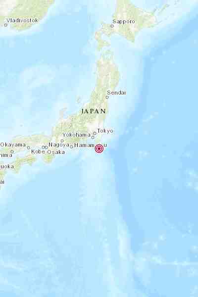
Magnitude: 3.6 Intensity: 1 Depth: 60000m
■■■■□□□□□□
Details: 2026-02-11 JST 01:12:46
Location: 千葉県南東沖 (Off the southeast Coast of Chiba Prefecture)
Map: https://www.google.com/maps/place/34°360%20N+140°1159%20E/@34.6,140.2,10z
#EarthQuake #Quake #Japan

Port of Half-Life 2 (2004) to Quake(World)
"The game is not playable from start to finish. You can play deathmatch and other odd modes."
Client Info
Server: https://mastodon.social
Version: 2025.07
Repository: https://github.com/cyevgeniy/lmst