#RapidMappingTeam

2024-02-05

RT by @CopernicusEU: #EMSR715

Since 3 February, #wildfires🔥 have been affecting a densely populated area in the Valparaiso region, in central #Chile🇨🇱

Our #RapidMappingTeam has been activated to monitor their consequences

Updates at👇
rapidmapping.emergency.coperni

🐦🔗: nitter.cz/CopernicusEMS/status

[2024-02-05 10:43 UTC]

2024-02-05

RT by @CopernicusEU: Desde el 3 de febrero, incendios forestales🔥 azotan la zona centro-sur de #Chile 🇨🇱, en particular
Valparaíso.

El #RapidMappingTeam del servicio de gestión de emergencias @CopernicusEU se ha activado para monitorear las consecuencias de los incendios.

Ver actualizaciones 👇

🐦🔗: nitter.cz/ECHO_LatAm/status/17

[2024-02-05 13:25 UTC]

2024-02-02

RT by @EU_ScienceHub: #CEMS in numbers

Over the past three years, our #RapidMappingTeam has been activated a total of 113 times in relation to #wildfires 🔥

➡️ 2022 marked the highest year for wildfire activations!

Find out more at👇
emergency.copernicus.eu/mappin

🐦🔗: nitter.cz/CopernicusEMS/status

[2024-02-02 09:25 UTC]

2024-02-01

RT by @EU_ScienceHub: In early January, our #RapidMappingTeam produced 9⃣9⃣ maps to support the efforts on the ground following the severe floods in the Lower Saxony region, #Germany 🇩🇪 #EMSR712

🔽Dataviz showing the maximum water extent between 6 and 7 January

More at👇
rapidmapping.emergency.coperni

🐦🔗: nitter.cz/CopernicusEMS/status

[2024-02-01 09:57 UTC]

2024-01-30

RT by @EU_ScienceHub: #DYK

In 2023, our #RapidMappingTeam achieved its 7⃣0⃣0⃣th activation milestone

We are proud to contribute to Emergency Management activities in Europe and beyond 🔥🚱🌊🧑‍🤝‍🧑🛰️

Find the full list of activations at👇
emergency.copernicus.eu/mappin

🐦🔗: nitter.cz/CopernicusEMS/status

[2024-01-30 11:08 UTC]

2024-01-12

RT by @UE_au_Maroc: According to >@EU_ECHO's #ERCC, 937 earthquakes above 5 M were recorded in the last 6 months of 2023

On 9 September 2023, our #RapidMappingTeam was activated in the aftermath of the #earthquake in #Morocco🇲🇦 to monitor its consequences in 8 AoIs

More👇
rapidmapping.emergency.coperni

🐦🔗: nitter.cz/CopernicusEMS/status

[2024-01-12 10:06 UTC]

Europäische Kommission - VertrEUinDE@respublicae.eu
2024-01-05

RT by @EUinDE: #EMSR713 #Floods🌊 in the #Saarland Länder, #Germany🇩🇪

Overnight, our #RapidMappingTeam delivered its Delineation Product using #Copernicus #Sentinel1🇪🇺🛰️ radar imagery

➡️A total flooded🌊 area of 131 ha has been detected

Updates at👇
rapidmapping.emergency.coperni

🐦🔗: nitter.cz/CopernicusEMS/status

[2024-01-05 09:36 UTC]

Europäische Kommission - VertrEUinDE@respublicae.eu
2024-01-03

RT by @EUinDE: #EMSR712 #Floods in #Germany 🇩🇪

Our #RapidMappingTeam has delivered a total of 4⃣0⃣ mapping products between 25 December & 3 January to support emergency responders

▶️10 updated Delineation Monitoring Products are expected to be delivered today

More👇
rapidmapping.emergency.coperni

🐦🔗: nitter.cz/CopernicusEMS/status

[2024-01-03 09:10 UTC]

2023-12-17

RT by @CopernicusEU: 🔴Update #EMSR711 #Floods in #France🇫🇷

Our #RapidMappingTeam has just delivered its Delineation Product for the #Rochefort AoI using 🛰️ radar imagery

Situation as of 15 December at 17:41 UTC:
▶️A total flooded area of 9⃣,0⃣1⃣6⃣ ha has been detected

🔗rapidmapping.emergency.coperni

🐦🔗: nitter.cz/CopernicusEMS/status

[2023-12-16 19:21 UTC]

EU Commissie in België / CommiEU4BE@respublicae.eu
2023-11-13

RT by @EU4BE: #EMSR708 #Floods in #Belgium🇧🇪

Over the weekend, our #RapidMappingTeam delivered its Delineation Product to assess the extent of the floods🌊 in the Westhoek Areas of Interest

As of 10 November:
➡️A flooded area of 5,516 ha has been detected

More at👇
rapidmapping.emergency.coperni

🐦🔗: nitter.cz/CopernicusEMS/status

[2023-11-13 09:27 UTC]

2023-11-09

RT by @europainitalia: #EMSR705 #Alluvione in #Toscana🇮🇹

Il nostro #RapidMappingTeam ha consegnato un totale di 🔟 prodotti tra il 4 ed il 9 Novembre

➡️L'estensione massima dell'evento identificata con le immagini satellitari🛰️ e' di 3,443 ettari

Maggiori informazioni al
🔗rapidmapping.emergency.coperni

🐦🔗: nitter.cz/CopernicusEMS/status

[2023-11-09 12:37 UTC]

2023-11-07

RT by @europainitalia: #EMSR705 #Alluvione in #Toscana🇮🇹

Il nostro #RapidMappingTeam ha consegnato nuovi prodotti nelle ultime ore

Al 6 Novembre, sono stati rilevati un totale di 1,690 ettari allagati🌊nelle aree di interesse di Fucecchio, Pontedera, e Orentano

🔗rapidmapping.emergency.coperni

🐦🔗: nitter.cz/CopernicusEMS/status

[2023-11-07 11:56 UTC]

2023-11-07

RT by @EUPakistan: #TogetherOneStepAhead

Before, during, and after the historic #PakistanFloods🇵🇰🌊 in 2022, we supported humanitarians on the ground, providing #floods forecasts with #GloFAS and detailed geospatial information with our #RapidMappingTeam

Read more at 👇
civil-protection-humanitarian-

🐦🔗: nitter.cz/CopernicusEMS/status

[2023-11-07 11:01 UTC]

2023-11-06

RT by @europainitalia: Aggiornamento #EMSR705 #Alluvione in #Toscana🇮🇹

Il nostro #RapidMappingTeam ha consegnato il Grading Product per l'AoI di Montemurlo

Al 5 Novembre, sono stati rilevati:
➡️194 ettari allagati🌊
➡️840 edifici colpiti🏘️

Maggiori informazioni al👇
rapidmapping.emergency.coperni

🐦🔗: nitter.cz/CopernicusEMS/status

[2023-11-06 12:06 UTC]

2023-11-04

RT by @CopernicusEU: Aggiornamento #EMSR705 #Alluvione in #Toscana🇮🇹

Il nostro #RapidMappingTeam ha consegnato il Delineation Product per l'area di Fucecchio, rilevando 284 ha allagati🌊

Nelle prossime ore sono previsti altri 6 prodotti

Maggiori informazioni al👇
rapidmapping.emergency.coperni

🐦🔗: nitter.cz/CopernicusEMS/status

[2023-11-04 17:55 UTC]

2023-11-04

RT by @CopernicusEU: #EMSR704 #Wildfire in #Spain🇪🇸

Our #RapidMappingTeam has delivered its Delineation Product for monitoring the consequences of the #IFMontitxelvo wildfire🔥

As of 3 November at 10:31 UTC:
A burnt area of 1,472 ha has been detected in the VHR 🛰️ imagery

rapidmapping.emergency.coperni

🐦🔗: nitter.cz/CopernicusEMS/status

[2023-11-04 18:21 UTC]

2023-11-03

RT by @europainitalia: Ancora alluvioni causate dal maltempo, questa volta in Toscana.

Il sistema #RapidMappingTeam di Copernicus è stato attivato per valutare i danni causati nelle zone di Prato, Fucecchio e Pontedera.

Il sistema di allerta continua il monitoraggio.

🐦🔗: nitter.cz/AParentiEU/status/17

[2023-11-03 11:28 UTC]

2023-10-19

RT by @CopernicusEU: In early September, severe flooding 🌊 hit eastern #Libya🇱🇾 devastating several areas

According to @UNOCHA as of 4 October, fatalities have reached 4,300+ & 42,000+ people have been internally displaced🧑‍🤝‍🧑

Our #RapidMappingTeam provided support to emergency responders #EMSR696

🐦🔗: nitter.cz/CopernicusEMS/status

[2023-10-19 08:54 UTC]

2023-10-15

RT by @EU_ScienceHub: Yesterday, our #RapidMappingTeam was activated for the 7⃣0⃣0⃣th time

We are proud to have supported so many Emergency Management activities worldwide🌍

Learn more about our mapping activities tomorrow at our #CEMS Annual Conference💡

👉e.copernicus.eu/CEMS_AnnualCon

🐦🔗: nitter.cz/CopernicusEMS/status

[2023-10-12 09:51 UTC]

Velocity22 🏴‍☠️Velocity2222@libretooth.gr
2023-08-29

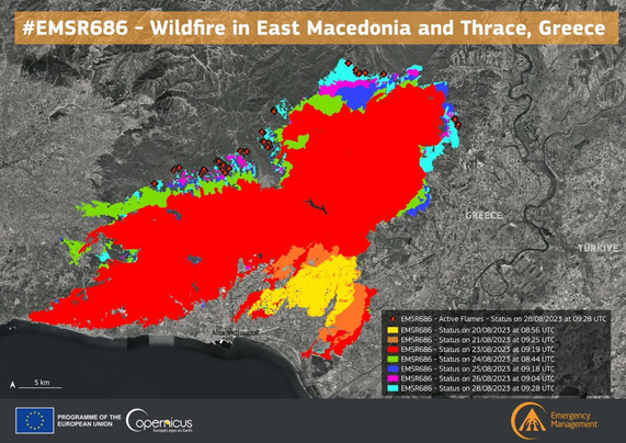
🔴Update #EMSR686 #Greece🇬🇷

Our #RapidMappingTeam delivered its 6⃣th Monitoring Product for the historic #wildfire that continues to ravage the areas north of #Alexandroupolis

🔥A total burnt area of 8⃣0⃣8⃣,7⃣ km2 has been detected, an area larger than #NewYorkCity🇺🇸
#antireport #antireportgr @antireportgr

storymaps.arcgis.com/stories/c

Client Info

Server: https://mastodon.social
Version: 2025.04
Repository: https://github.com/cyevgeniy/lmst