#Sentinel1

Olivier D'Hondt 🛰️🌍🌱tyldurd@framapiaf.org
2025-06-09

🚀 EO-Tools v2024.6.0 is out!

This update brings minor improvements and fixes:
🛠️ Added a sample EODAG config
🛰️ Orbit directory now configurable per function
📦 Improved and modernized type hints
⬆️ Dependencies upgraded

🔗 eo-tools.readthedocs.io/en/lat

#EOtools #RemoteSensing #Python #Sentinel1 #InSAR #EarthObservation #SyntheticApertureRadar
2025-05-18

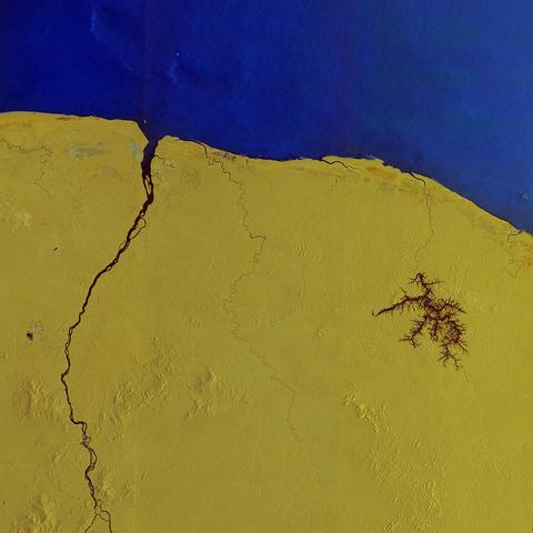
❓ Réponse de l'image mystère : il s'agit de la Guyane française photographiée par le satellite #Sentinel1 du programme #Copernicus.
Les couleurs proviennent de la combinaison de deux polarisations de l'image radar, auxquelles une couleur a été attribuée et convertie en un seul composite.
Plus d'infos : flickr.com/photos/europeanspac

Olivier D'Hondt 🛰️🌍🌱tyldurd@framapiaf.org
2025-04-24

🚀 EO-Tools 2025.4.0 is out!

🌐 New in this release:
- Support for Sentinel-1C products!
- H-Alpha dual-pol decomposition from SLCs 🛰️

📘 Dive in: eo-tools.readthedocs.io
💻 Code: github.com/odhondt/eo_tools

#EO_tools #RemoteSensing #Sentinel1 #SAR #EarthObservation #OpenSource #Python

Olivier D'Hondt 🛰️🌍🌱tyldurd@framapiaf.org
2025-04-17

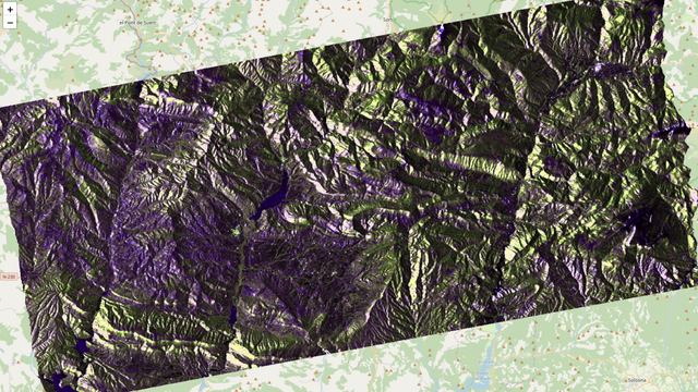
It's hard to get proper visualizations of SAR imagery due to high image dynamics. I have spent quite some time tweaking this one, which represents the parameters of the dual-pol H-alpha decomposition on the new Sentinel-1C sensor! Disclaimer: it's visually compelling, but probably not physically accurate. :)
#Sentinel1 #eo_tools #SyntheticApertureRadar #EarthObservation #python #RemoteSensing

Pseudo color image of the H-Alpha decomposition on a mountaineus area. Entropy, Alpha and intensity are represented by resp color saturation, hue and value.
Olivier D'Hondt 🛰️🌍🌱tyldurd@framapiaf.org
2025-02-11

🚀 EO-Tools 2025.2.0 is out!
No new features this time, but several fixes and code improvements.

🔹 Breaking change: to make parameter names more consistent, several function calls have changed—check the version notes and API reference for details.

📖 Full details: eo-tools.readthedocs.io/en/lat

#RemoteSensing #SAR #EarthObservation #Sentinel1 #python

2025-02-09

The way to Sentinel-1C operations
This article describes the steps from the launch of the satellite to the distribution of the images.
#remotesensing #sentinel1
sentinels.copernicus.eu/web/se

2025-01-30

On 27 January 2025, Storm Herminia struck parts of Spain, Portugal, France, the UK, and Ireland.

This image, by #Sentinel1, shows the flooded areas south and east of Rennes.

Learn more:
copernicus.eu/en/media/image-d
---
nitter.privacydev.net/Copernic

Zeitgeisty Aphorismszeitgeisty
2025-01-26

The way to passes through .

2025-01-23

Interesting look at the Mississippi River in #Sentinel1 #SAR adjacent to Herculaneum, MO. In this multi-temporal false-color composite, the yellow line is the rough and exposed ice edges left in the wake of a ship breaking through the much smoother sheet ice which appears black. The blue features in the water are ships that were acquired in summer time images, ghosts of shipping past.

SAR image of a reach on the Mississippi River where ice breaking operations are apparent.  Where the ice breaking ship has steamed through, SAR backscatter is higher due to the exposed edges of ice and crumbled ice left in it's wake.
2025-01-16

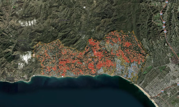
Use of Sentinel-1 satellite to assess landscape changes due to the Palisades Fire (via NASA). #PalisadesFire #RemoteImaging #Wildfires #Sentinel1

This map displays change detection imagery from areas impacted by wildfires in Southern California. Change is detected using a logarithmic difference calculation to highlight where change has occurred in Sentinel-1 Synthetic Aperture Radar (SAR) imagery between Dec. 28, 2024, and Jan. 9, 2025. In general, the forested areas impacted by fire appear red, as the structural complexity of the canopy is decreased when vegetation is burned. Urban areas appear blue, as burned buildings are more irregular in structure than rooftops. Credits: Log Difference layer generated by Alaska Satellite Facility (ASF). Source 10-m Sentinel-1 RTC products in power scale were processed by ASF DAAC HyP3 2025 using GAMMA software. Contains modified Copernicus Sentinel data 2025, processed by ESA. Wildfire perimeters courtesy of CAL FIRE
2025-01-13

Still concerning the L.A. wildfires observed through interferometric coherence evolution, a descending pass #Sentinel1 A image was acquired ~12hours after the ascending one.
So, here is a twelve-days interferometric coherence evolution 12 hours apart.
There is certainly slope effects due to incidence angle variation but some losses of coherence in twelve hours are clearly visible.

2025-01-10

Concerning the L.A. wildfires, here is a quick view of #InSAR coherence evolution between #Copernicus #ESA #Sentinel1 images of December 16 2024, December 28 2024 and January 9 2025.

Burnt area between last two dates are characterized by strong and abrupt coherence losses.
This gives an idea of the burnt surface in a twelve days delay.

2024-12-11

🛰️📷 Le satellite #Sentinel1 C a été lancé le 5 novembre pour renforcer le programme européen Copernicus. Moins d'une semaine après, voici les premières images acquises par son radar : le Svalbarg, Amsterdam et la région du Flevoland, et Bruxelles.
Via ESA

2024-12-10

📢Our research on mapping societal material stocks 🏡🚗 is now featured on the #CDSE page as a use case! #sentinel1 #sentinel2 dataspace.copernicus.eu/cases/

2024-12-10

Now that #Sentinel1-C is in orbit when can we expect the first data?

The commissioning phase is expected to take about four months, although it may extend further. For reference, Sentinel-1A took six months from its launch in April 2014 to become operational in October 2014. Thus, a little more patience may be required.

#remotesensing #earthobs

2024-12-06

🚀 Retour en vol réussi pour #VegaC ce jeudi soir.
Le vol #VV25 a placé sur orbite héliosynchrone à 700 km d'altitude le satellite d'observation radar #Sentinel1-C de l'ESA pour le programme Copernicus

ネコビデオ ビジュアル ソリューションズnvslive@mstdn.jp
2024-12-06

RT @ESA_transport: 🚀 To orbit #Sentinel1 C!

Vega-C shoots towards the stars with Copernicus Earth observer aboard.

Liftoff was at 18:20 l…

ネコビデオ ビジュアル ソリューションズnvslive@mstdn.jp
2024-12-06

RT @esa: Vega-C has successfully returned to flight carrying @CopernicusEU Earth observer #Sentinel1 C to space on 5 December 2024.

The mi…

2024-12-05

📢 Soir de lancement
🚀 #VegaC #VV25
🛰 Satellite d'observation radar #Sentinel1-C de l'ESA
⏰ 21h20 UTC
🌎 Centre spatial Guyanais, France
📷 ESA-CNES-ARIANESPACE / S-Martin
📺 Arianespace : youtube.com/live/4XVo-c9E9LQ - ESA : esawebtv.esa.int

Client Info

Server: https://mastodon.social
Version: 2025.04
Repository: https://github.com/cyevgeniy/lmst