#WDEFWeather #News12Weather #BlipCast Thursday: Another beautiful day for the area. Weather becomes less hospitable into the upcoming holiday weekend.
Details tonight on @WDEFnews12 at 5:30, 6, 7 & 11.
#WDEFWeather #News12Weather #BlipCast Thursday: Another beautiful day for the area. Weather becomes less hospitable into the upcoming holiday weekend.
Details tonight on @WDEFnews12 at 5:30, 6, 7 & 11.
#WDEFWeather #News12Weather #BlipCast Wednesday - Dry and sunny mid-week, makes for a nice change after last night's rough weather. Into the holiday weekend soon, how does the weather for outdoor activities look? That forecast tonight on @WDEFNews12.
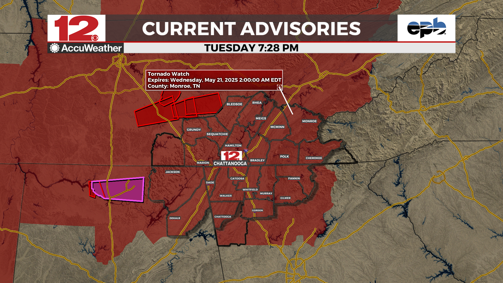
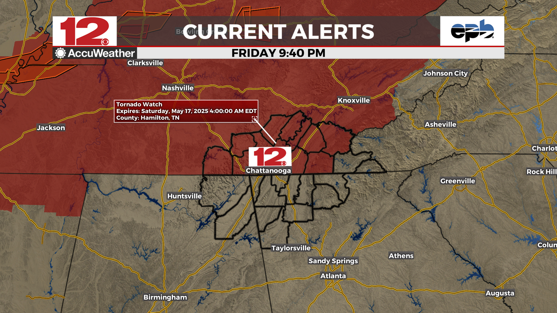
#WDEFNews12 #WDEFWeather #News12Weather - New #TornadoWatch issued for the eastern @WDEFNews12 viewing area, in effect until 2 AM EDT.
Tornado watch continues for the western viewing area until 11 PM EDT.
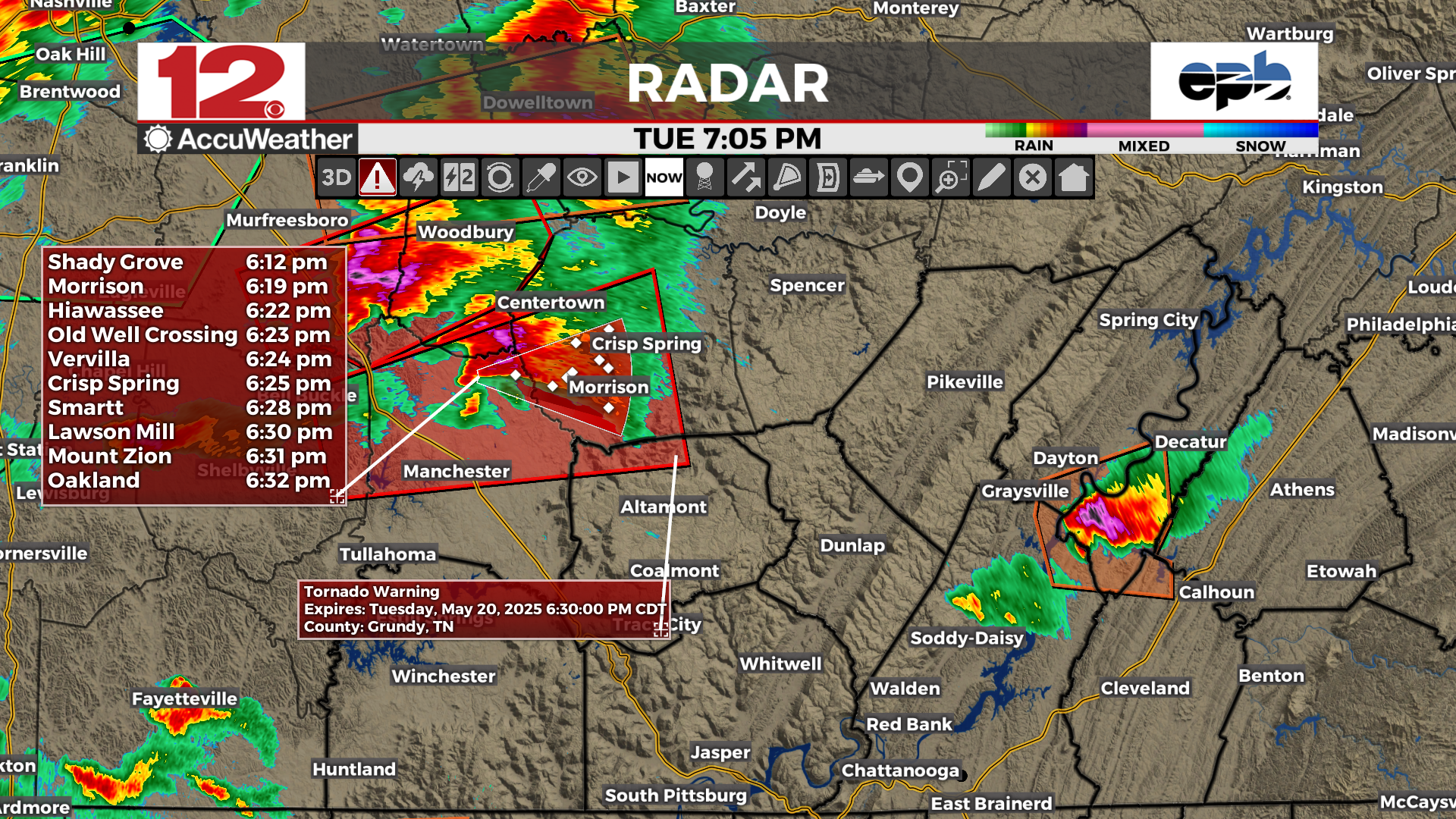
#WDEFWeather #News12Weather - #TornadoWarning for extreme NW Grundy County TN in the @WDEFNews12 viewing area. Risk for tornadoes and 1"+ hail. Most of the storm should pass north of this area. Viewers in NW Grundy County should be prepared to move to shelter.
#WDEFWeather #News12Weather #BlipCast Tuesday: Quiet for now. More storms tonight, some strong to severe. Time to remain #weatheraware through the evening hours.
Details on your forecast tonight on @WDEFNews12 at 5:30, 6, 7 & 11.
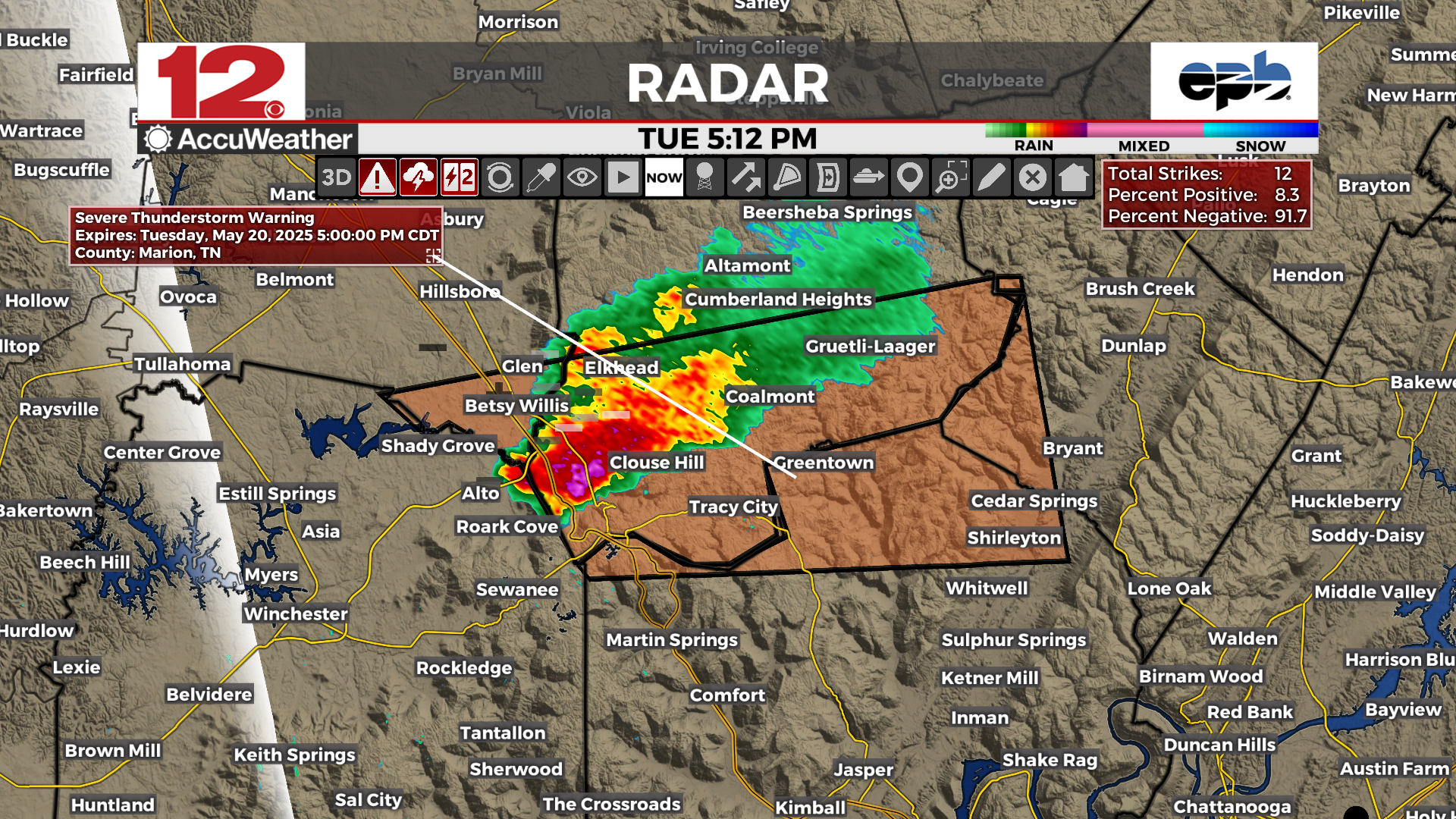
#WDEFWeather #News12Weather - Severe thunderstorm warning for Grundy, Sequatchie & Marion Counties TN. Winds of 60 MPH and quarter sized hail possible for the warned area.
This storm is not currently tornadic but could become so again at any time. Be prepared to get to shelter.
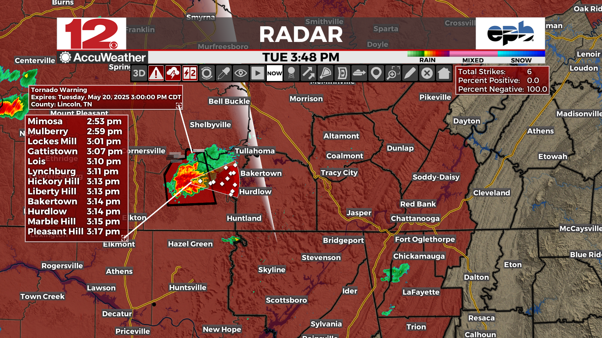
#WDEFWeather #News12Weather -- As of 3:50 PM EDT, viewers in Grundy & Marion Counties TN should monitor this tornado producing storm. If it continues on its current track, it will be crossing I-24 and moving east into the @WDEFnews12 viewing area within the hour. Be prepared to move to shelter if warnings are issued.
#WDEFWeather #News12Weather - Quiet for Monday evening, more storms possible tonight. Better potential for severe weather again on Tuesday.
Definitely a time to be #WeatherAware and we'll help you do that tonight on @WDEFNews12.
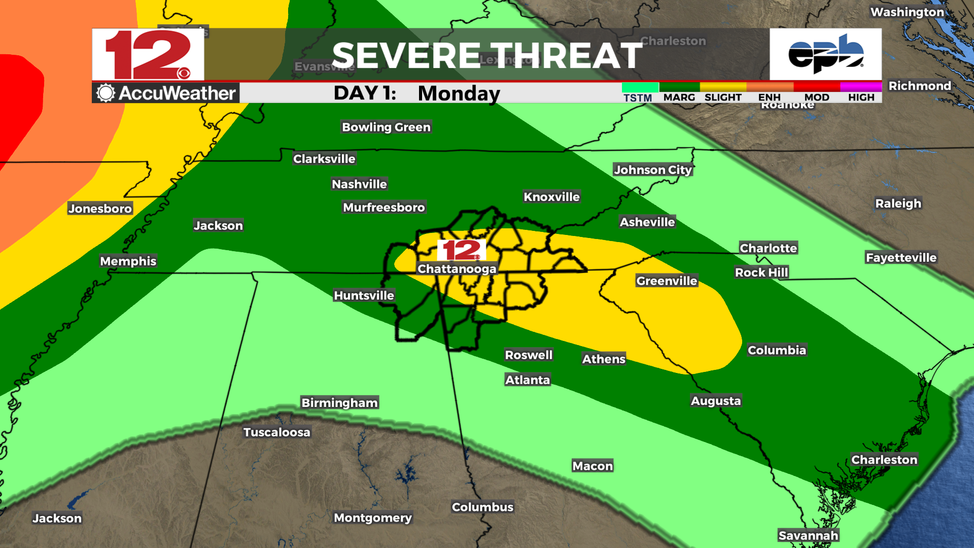
#WDEFweather #News12Weather -- Slight Risk of severe weather for Monday evening gets raised to a 3/5 Enhanced Risk on Tuesday afternoon/evening.
All modes of severe weather will be in play Tuesday: damaging winds, tornadoes and hail, with a slight risk for flash flooding.
#StayTuned and be #WeatherAware tonight and tomorrow

#WDEFWeather #News12Weather - Latest severe storm over NE Hamilton County TN has some possible rotation going on. As of 2:20 AM EDT, no word from NWS on potential tornado warning. Anything between Big Spring, Etola, Brittsville and I-75 should be ready to move to shelter if need arises.
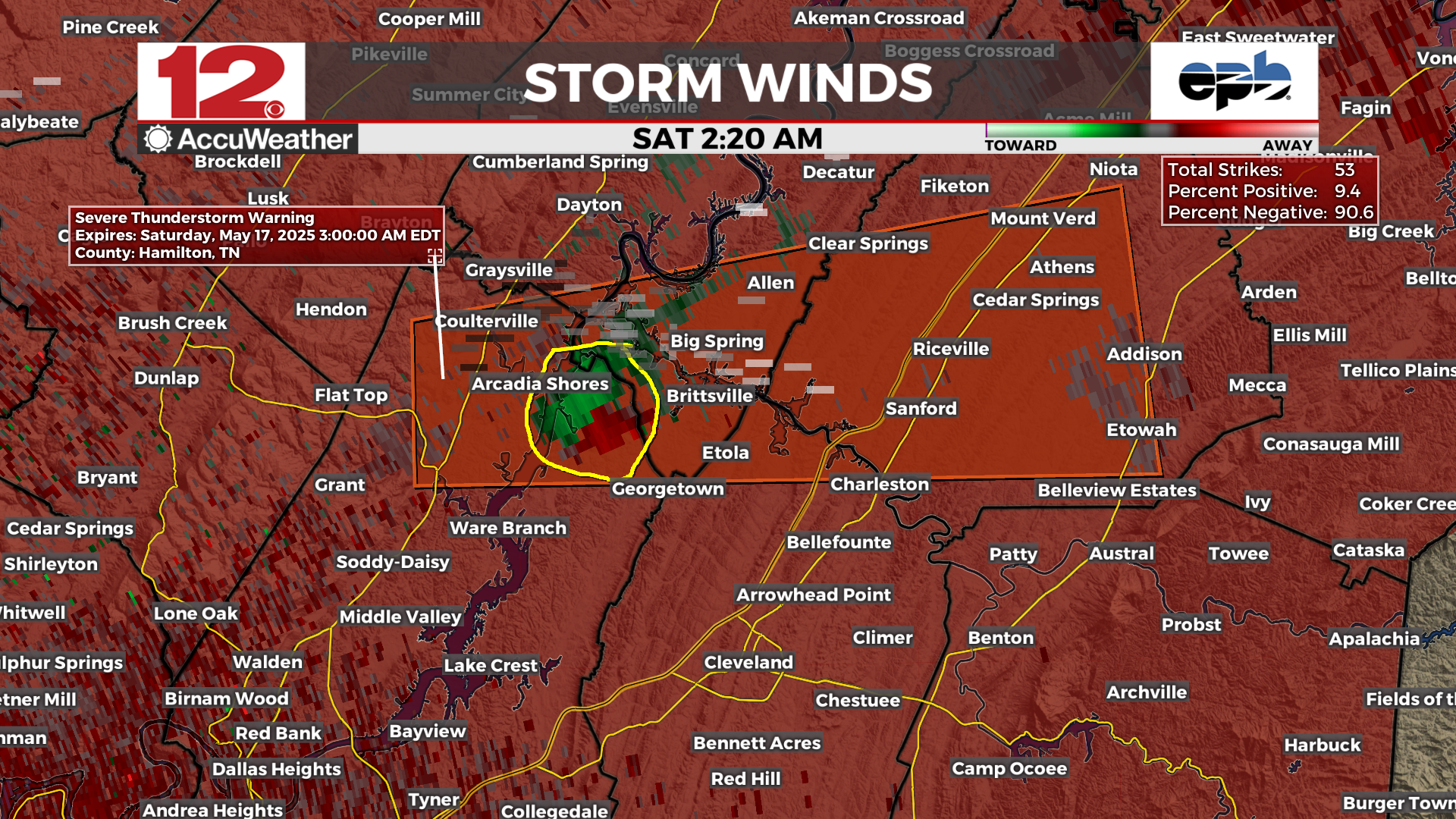
#WDEFWeather #News12Weather - Quick #severeweatherupdate for 2 AM EDT Saturday morning as more thunderstorms develop across areas north and west of Chattanooga. #TornadoWatch remains in effect until 3 AM CDT / 4 AM EDT. Time to remain #WeatherAware.
#WDEFWeather #News12Weather - Distant #lightning from the Island Cove Marina & Resort webcam on the @EPB Fiber Optics Weathercam Network very early Saturday morning as thunderstorms develop to the northwest of #ChattanoogaTN.
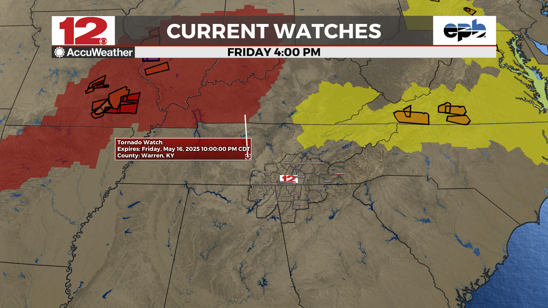
#WDEFWeather #News12Weather - #TornadoWatch 271 issued for SE Tennessee counties in the @WDEFNews12 viewing area until 3 AM CDT / 4 AM EDT Saturday.
#WDEFWeather #News12Weather - As of 4 PM EDT, no watches posted for the @WDEFNews12 viewing area. Severe threat remains in the forecast for tonight; all severe modes possible. Time to be #WeatherAware and have your #SevereWeatherPlan in place. #StayTuned
#WDEFWeather #News12Weather #BlipCast Thursday: Quiet but warm Thursday. Could be a stormy end to the week as a new storm system energizes to our northwest.
Details tonight on @WDEFNews12 at 5:30, 6, 7 & 11 and at wdef.com/weather
#wdefWeather #News12Weather #BlipCast Wednesday: Warm and humid but relatively rain free for peak of the week. More rain/thunder tonight then catching a break for the next couple of days.
Details tonight on @WDEFNews12 at 5:30, 6, 7 & 11.
#WDEFWeather #News12Weather #BlipCast Tuesday: Our latest storm system is weakening and moving off a bit, but still enough to create widespread showers and thunder.
Details tonight on @WDEFNews12 at 5:30, 6, 7 & 11.
#WDEFWeather #News12Weather - Out for a nosh and a flicker tonight, comfortable temperatures but take the rain gear just in case.

#WDEFWeather #News12Weather BlipCast Monday: More showers and thunderstorms and warmer temperatures ahead for this week.
Stay tuned for more forecast information tonight on @WDEFNews12 at 5:30, 6, 7 & 11.
#WDEFWeather #News12Weather - #Sundogs visible on either side of the setting sun on the @ChattanoogaZoo @EPB webcam system.