I really get tired of articles like this that report as social media mstters
♻️That's illegal:Woman looks up her parents' neighborhood on Apple Maps. Then she spots a mystery business#GPSMapping #WebCrawlr #TikTokMaggie #SatelliteNavigation #OrganPlaceMysteryhttps://www.dailydot.com/news/apple-maps-mystery-business/
#satellitenavigation
"Finally, my coffee break won't involve getting lost in the cosmos! 🚀🛰️ #SatelliteNavigation #LostNoMore #RidingTheWavesOfSpace"
- John online, Earth Navigation Minister
Apr 13, 1960 - The United States launches Transit 1-B, the world's first satellite navigation system.
https://en.wikipedia.org/wiki/Transit_(satellite)
Indian navigation satellite stuck in transfer orbit after propulsion failure
Satellite Signal Anti-Jamming Shield for French Rafale Fighters, Military Helicopters
#DGA #ThalesAVS #CRPA #SatelliteJamming #MilitaryTech #FrenchArmy #RafaleFighter #HelicopterTechnology #SignalJamming #DefenseInnovation #TacticalAutonomy #MilitaryAviation #FrenchNavy #HelicopterResilience #SatelliteNavigation
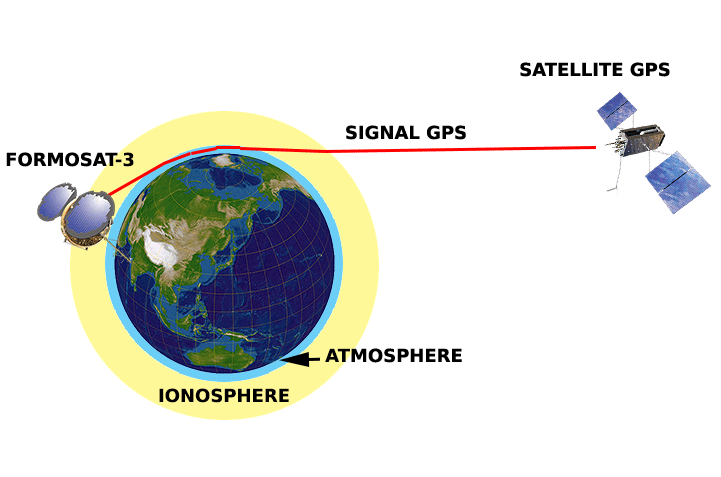
Radio occultation (Planetary science 🪐)
Radio occultation is a remote sensing technique used for measuring the physical properties of a planetary atmosphere or ring system. Satellites carrying onboard GNSS-Radio occultation instruments include CHAMP, GRACE and GRACE-FO, MetOp and the recently launched COSMIC-2.
https://en.wikipedia.org/wiki/Radio_occultation
#RadioOccultation #Radio #PlanetaryScience #SatelliteNavigation #SatelliteMeteorology
ヨーロッパ連合の地球観測と衛星航法担当のChristoph Kautzが、Ariane 6について説明。ヨーロッパの自立した宇宙へのアクセスや安全保障、科学、宇宙探査などの重要性を紹介。
https://x.com/Arianespace/status/1816819343453290563
#Ariane6 #EarthObservation #SatelliteNavigation #Europe #AccessToSpace #security #space
GNSS reflectometry (Remote sensing 🛰️)
GNSS reflectometry involves making measurements from the reflections from the Earth of navigation signals from Global Navigation Satellite Systems such as GPS. The idea of using reflected GNSS signal for earth observation became more and more popular in the mid-1990s at NASA Langley Research Center and is also known as GPS reflectometry. Research ap...
Gladys West Modelled the Earth So That We Can Have GPS
The name Gladys West is probably unfamiliar, but she was part of creating something you probably use often enough: GPS. You wouldn't think a child who grew up on a sharecropping farm would wind up as an influential mathematician, but perhaps watching her father work very hard for very little and her mother working for a tobacco company made her realize that she wanted more for herself. Early on, she decided that education was the way out. She made it all the way to the Naval Surface Warfare Center.
While she was there she changed the world with -- no kidding -- mathematics. While she didn't single-handedly invent satellite navigation, her work was critical to the systems we take for granted today.
Flying High
West had a passion for satellite altimeters. We think of a satellite being a certain height over the surface of the Earth, but that's not really accurate. The Earth's surface isn't a smooth ball. Passing over a hill or a valley means that the exact distance from the surface to the satellite changes almost constantly. Passing over water is another problem. If you want to be precise, all these things matter. And if you want to build a Global Positioning System, you want to be precise.
West modeled the Earth's exact shape based on data from the GEOS satellite. She later became the project manager for SEASAT, which used radar to measure the ocean surface. Her interest led her to work with the IBM 7030 computer to refine models of the Earth known as the geoid. This takes into account things like tidal forces and gravity to compute the true shape of the Earth, rather than simply assuming that it's a perfect sphere. An accurate geoid is an important part of today's GPS and similar navigations systems.
Full Ride
Her family did not have the money to send West to school, so she worked hard to earn a full scholarship. The top two graduating high school students got a full ride and through discipline and her intellect, graduated valedictorian in 1948.
She was excellent in all her subjects but elected to major in math. After a brief tenure teaching, she went back for a Master's degree. Even with an advanced degree, though, teaching didn't pay very well. Despite her trepidation in moving to Virginia during the 1960s, the Navy job offered her a better wage and she stayed in that job until retirement over four decades later.
Legacy
West received several awards during her time at work. In addition, she was inducted into the Air Force Hall of Fame in 2018. The Navy even produced a short video that you can see below.
Of course, many people worked on GPS -- known as NAVSTAR at its inception. It wasn't even the first system of its kind. That honor probably goes to the 1960 Transit project. But all of these systems needed accurate mathematical models of the Earth, and West was a key part of the team that made that happen. Making accurate clocks, keeping them in sync, and shrinking all the components down with a low cost have their own stories and heroes, but for the math, we can thank Gladys West.
We like knowing the stories behind the tech we use every day. We think Gladys West is even more inspiring because of her humble beginnings and the obvious determination and intellect she had to carry her so far. Gladys got her PhD after she retired, but we understand she still prefers to use paper maps.
Want to know more about GPS? We can help. Just want to use it? We've come a long way from $3,000 handheld GPS units.
#biography #featured #gpshacks #originalart #geoid #gps #measurement #navy #satellitenavigation

Radio astronomers and satellite navigation engineers are focusing their attention on the same point of the sky, looking into methods of improving both #satnav accuracy and radio astronomy. www.esa.int/Our_Activities/Nav… #satellitenavigation #Galileo #EGNOS #groundpositioningsystems
This year’s ESA–Joint Research Centre International Summer School on Global Navigation Satellite Systems is taking place in July, in the spa resort of Loipersdorf, Austria.
#SingUp www.esa.int/Our_Activities/Nav… #satellitenavigation #Galileo #EGNOS #groundpositioningsystems
#SingUp www.esa.int/Our_Activities/Nav… #satellitenavigation #Galileo #EGNOS #groundpositioningsystems
Europe has four more #Galileo #navigation satellites in the sky following their launch on an Ariane 5 rocket. After today’s success, only one more launch remains before the Galileo constellation is complete and delivering global coverage. http://www.esa.int/Our_Activities/Navigation/Galileo_launch_brings_navigation_network_close_to_completion #satellitenavigation #Galileo #EGNOS #groundpositioningsystems
Europe’s next four #Galileo navigation satellites are in place atop their Ariane 5, ready to be launched next Tuesday. Liftoff from Europe’s Spaceport in Kourou, French Guiana is scheduled for 18:36 GMT (19:36 CET, 15:36 local time), carrying Galileo satellites 19–22. http://www.esa.int/Our_Activities/Navigation/Galileo_satellites_atop_rocket_for_next_Tuesday_s_flight #satellitenavigation #Galileo #EGNOS #groundpositioningsystems
ESA is considering extending its activities to a new region of the sky via a novel type of aerial vehicle, a ‘missing link’ between drones and satellites.
High Altitude Pseudo-Satellites, or #HAPS, are platforms that float or fly at high altitude like conventional aircraft but operate more like satellites – except that rather than working from space they can remain in position inside the atmosphere for weeks or even months, offering continuous coverage of the territory below. http://www.esa.int/Our_Activities/Navigation/Crossing_drones_with_satellites_ESA_eyes_high-altitude_aerial_platforms #satellitenavigation #Galileo #EGNOS #groundpositioningsystems
High Altitude Pseudo-Satellites, or #HAPS, are platforms that float or fly at high altitude like conventional aircraft but operate more like satellites – except that rather than working from space they can remain in position inside the atmosphere for weeks or even months, offering continuous coverage of the territory below. http://www.esa.int/Our_Activities/Navigation/Crossing_drones_with_satellites_ESA_eyes_high-altitude_aerial_platforms #satellitenavigation #Galileo #EGNOS #groundpositioningsystems
Europe’s next four #Galileo #navigation satellites and the #Ariane5 rocket due to lift them into orbit are being readied for their 12 December launch from Europe’s Spaceport in Kourou, French Guiana. Tuesday saw Galileo satellites 19–22 declared ready for flight, along with their Ariane. Combined activities are now under way, culminating in the satellites meeting their rocket in the Final Assembly Building. http://www.esa.int/Our_Activities/Navigation/Galileo_quartet_fuelled_and_ready_to_fly #satellitenavigation #Galileo #EGNOS #groundpositioningsystems
Two more #Galileo #satellites have reached Europe’s Spaceport in French Guiana, joining the first pair of navigation satellites and the #Ariane5 rocket due to haul the quartet to orbit this December.
Galileos 21 and 22 left Luxembourg Airport on a Boeing 747 cargo jet on the morning of 17 October, arriving at Cayenne – Félix Eboué Airport in French Guiana on the same day. http://www.esa.int/Our_Activities/Navigation/Galileo_in_place_for_launch_then_there_were_four #satellitenavigation #Galileo #EGNOS #groundpositioningsystems
Galileos 21 and 22 left Luxembourg Airport on a Boeing 747 cargo jet on the morning of 17 October, arriving at Cayenne – Félix Eboué Airport in French Guiana on the same day. http://www.esa.int/Our_Activities/Navigation/Galileo_in_place_for_launch_then_there_were_four #satellitenavigation #Galileo #EGNOS #groundpositioningsystems
Europe’s next two #Galileo #navigation #satellites have touched down in Europe’s Spaceport in French Guiana ahead of the launch of a quartet by #Ariane5 at the end of this year.
Galileos 19 and 20 left Luxembourg Airport on a Boeing 747 cargo jet on the morning of 18 September, arriving at Cayenne – Félix Eboué Airport in French Guiana that evening. http://www.esa.int/Our_Activities/Navigation/Galileo_pair_arrives_in_French_Guiana #satellitenavigation #Galileo #EGNOS #groundpositioningsystems
Galileos 19 and 20 left Luxembourg Airport on a Boeing 747 cargo jet on the morning of 18 September, arriving at Cayenne – Félix Eboué Airport in French Guiana that evening. http://www.esa.int/Our_Activities/Navigation/Galileo_pair_arrives_in_French_Guiana #satellitenavigation #Galileo #EGNOS #groundpositioningsystems
Four of the latest set of #Galileo #navigation #satellites will be launched on #Ariane6 rockets – ESA’s first contract to use Europe’s new vehicle.
The launches are scheduled between the end of 2020 and mid-2021, using two Ariane 62 rockets – the configuration of Europe’s next-generation launch vehicle that is best suited to haul the two 750 kg navigation satellites into their orbits at 23 222 km altitude. http://www.esa.int/Our_Activities/Navigation/Galileos_set_to_fly_on_Ariane_6 #satellitenavigation #Galileo #EGNOS #groundpositioningsystems
The launches are scheduled between the end of 2020 and mid-2021, using two Ariane 62 rockets – the configuration of Europe’s next-generation launch vehicle that is best suited to haul the two 750 kg navigation satellites into their orbits at 23 222 km altitude. http://www.esa.int/Our_Activities/Navigation/Galileos_set_to_fly_on_Ariane_6 #satellitenavigation #Galileo #EGNOS #groundpositioningsystems
The last of 22 #Galileo #satellites has departed ESA’s Test Centre in the Netherlands – concluding the single longest and largest scale test campaign in the establishment’s history.
Cocooned in a protective container for its journey – equipped with air conditioning, temperature control and shock absorbers – the final Galileo satellite left the establishment by lorry on 24 August. http://www.esa.int/Our_Activities/Navigation/Last_Galileo_leaves_ESA_s_Test_Centre #satellitenavigation #Galileo #EGNOS #groundpositioningsystems
Cocooned in a protective container for its journey – equipped with air conditioning, temperature control and shock absorbers – the final Galileo satellite left the establishment by lorry on 24 August. http://www.esa.int/Our_Activities/Navigation/Last_Galileo_leaves_ESA_s_Test_Centre #satellitenavigation #Galileo #EGNOS #groundpositioningsystems
Each #Galileo #satellite must go through a rigorous #test campaign to assure its readiness for the violence of launch, airlessness and temperature extremes of Earth orbit.
Each one is despatched to a unique location in Europe to ensure its readiness prior to launch: a 3000 sq m cleanroom complex nestled in sandy dunes along the Dutch coast, filled with test equipment to simulate all aspects of spaceflight. http://www.esa.int/Our_Activities/Navigation/How_each_Galileo_satellite_is_tested_ahead_of_launch #satellitenavigation #Galileo #EGNOS #groundpositioningsystems
Each one is despatched to a unique location in Europe to ensure its readiness prior to launch: a 3000 sq m cleanroom complex nestled in sandy dunes along the Dutch coast, filled with test equipment to simulate all aspects of spaceflight. http://www.esa.int/Our_Activities/Navigation/How_each_Galileo_satellite_is_tested_ahead_of_launch #satellitenavigation #Galileo #EGNOS #groundpositioningsystems
Client Info
Server: https://mastodon.social
Version: 2025.04
Repository: https://github.com/cyevgeniy/lmst