The National Weather Service in Aberdeen issued an urgent weather message early Monday morning, warning of a heat advisory in effect from 1 PM this afternoon to 7 PM CDT this evening.
👉 Read here: https://www.mykxlg.com/news/local/heat-advisory-issued-for-south-dakota-counties-amid-rising-temperatures/article_b5ea8b3c-3224-11ef-85db-cb657372d011.html
#sdweather
🚨 A severe thunderstorm warning was issued for southwestern Roberts, southeastern Day, and northwestern Grant counties in SD until 6:30 AM CDT on Wednesday, June 12, 2024.
👉 READ more: https://zurl.co/siqi
#SDWeather #ThunderstormWarning #KXLGNews
#KXLGRadio #LiveandLocal
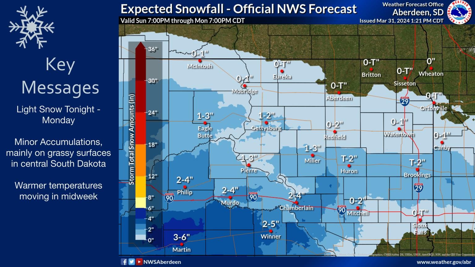
Light snow to persist through today and into Monday morning, with minor accumulations expected mainly on grassy surfaces in central SD. Warmer temperatures are forecasted for mid-week.
#SDweather #snowfall #winterforecast #KXLG #NWSAberdeen
@NWSAberdeen
Severe winter storm conditions across South Dakota, causing snow-packed and ice-covered roads along Interstates 90 and 29. Accumulating snow, refreezing precipitation, and strong winds reported #SouthDakota #WinterStorm #KXLGNews #KXLG #weather #SDWeather
https://zurl.co/3U3G
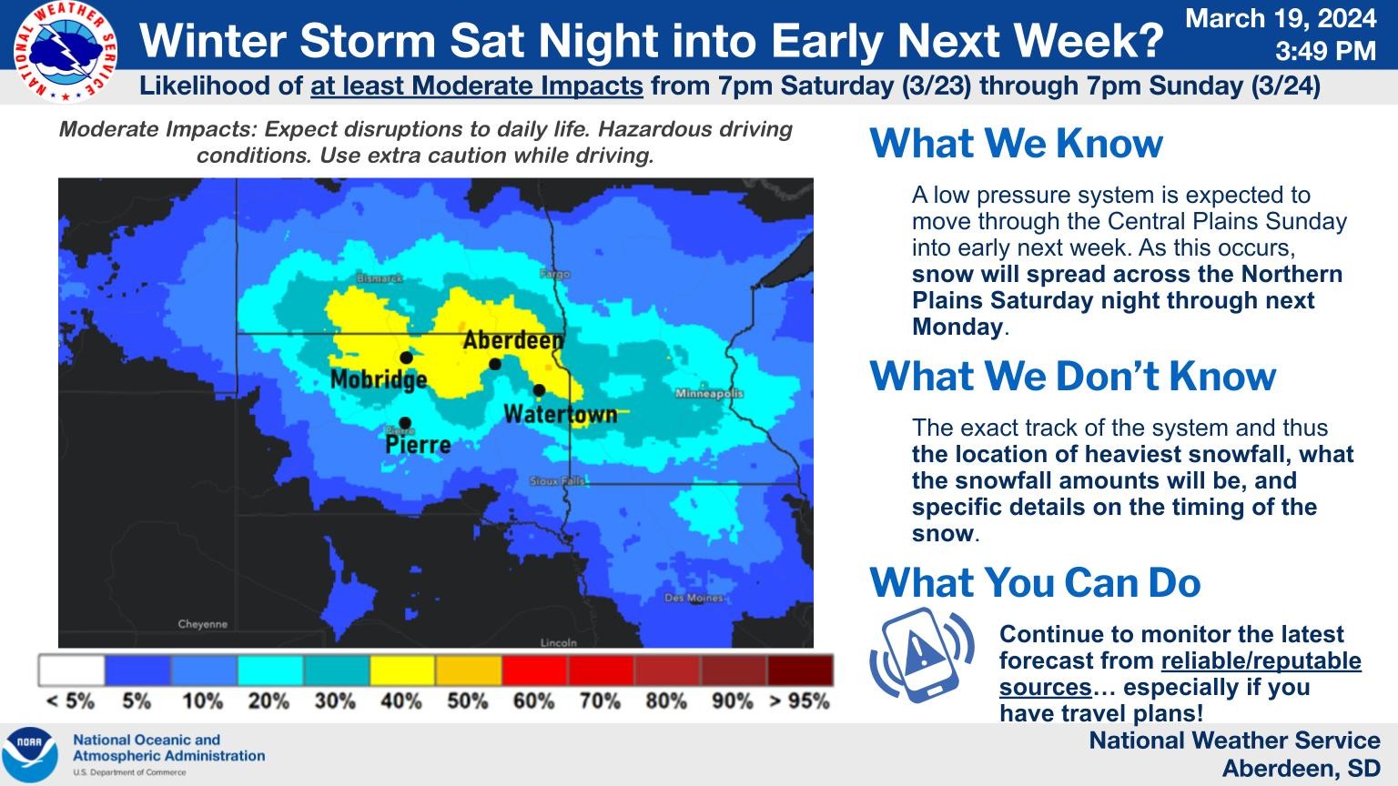
Here is the latest information concerning the upcoming storm system. Prepare and be safe. Hazardous travel conditions are expected! #NWSAberdeen #weather #sdweather #winterstorm
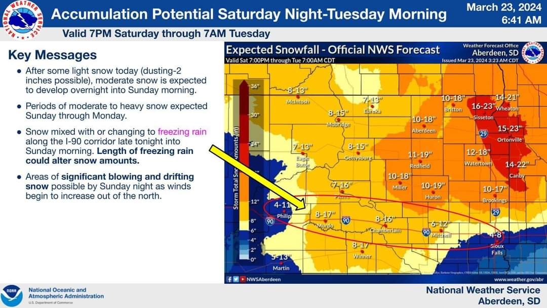
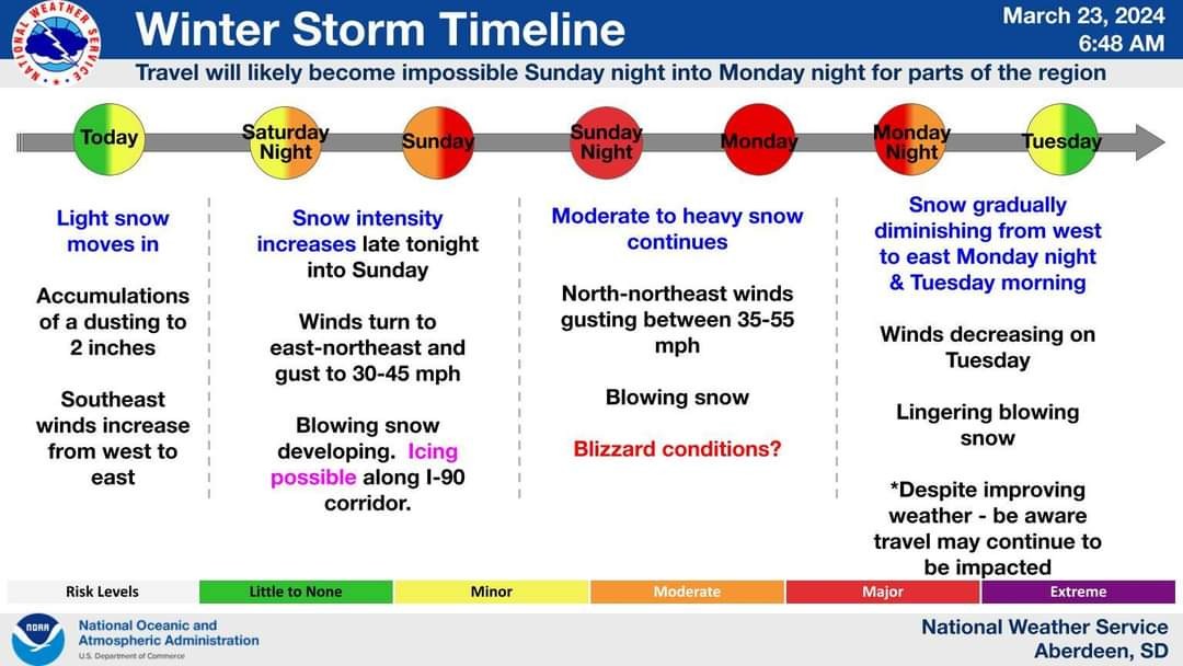
South Dakota is preparing for a severe winter storm as blizzard conditions are expected to hit portions of the state from Saturday evening through late Monday night. Stay safe and stay tuned to #KXLG for updates. #SDWeather #WinterStorm #travelsafe
https://zurl.co/wmN5
City of Watertown's Street Maintenance division takes proactive measures to ensure road safety by initiating salt brine pre-treatment ahead of the predicted snowfall. #WinterSafety #KXLGNews #KXLG #SDWeather #SDNews #winterdriving #roadsafety
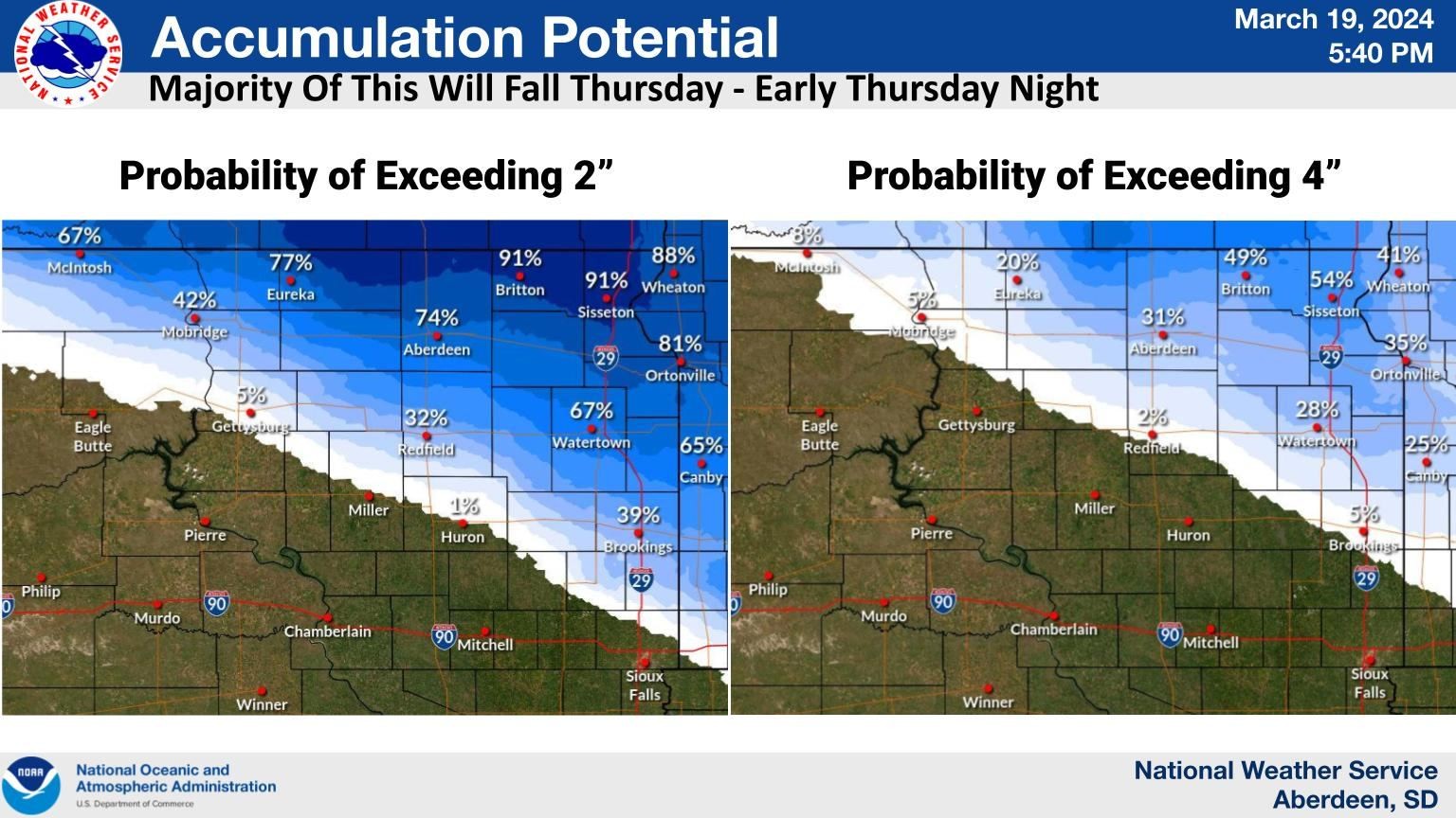
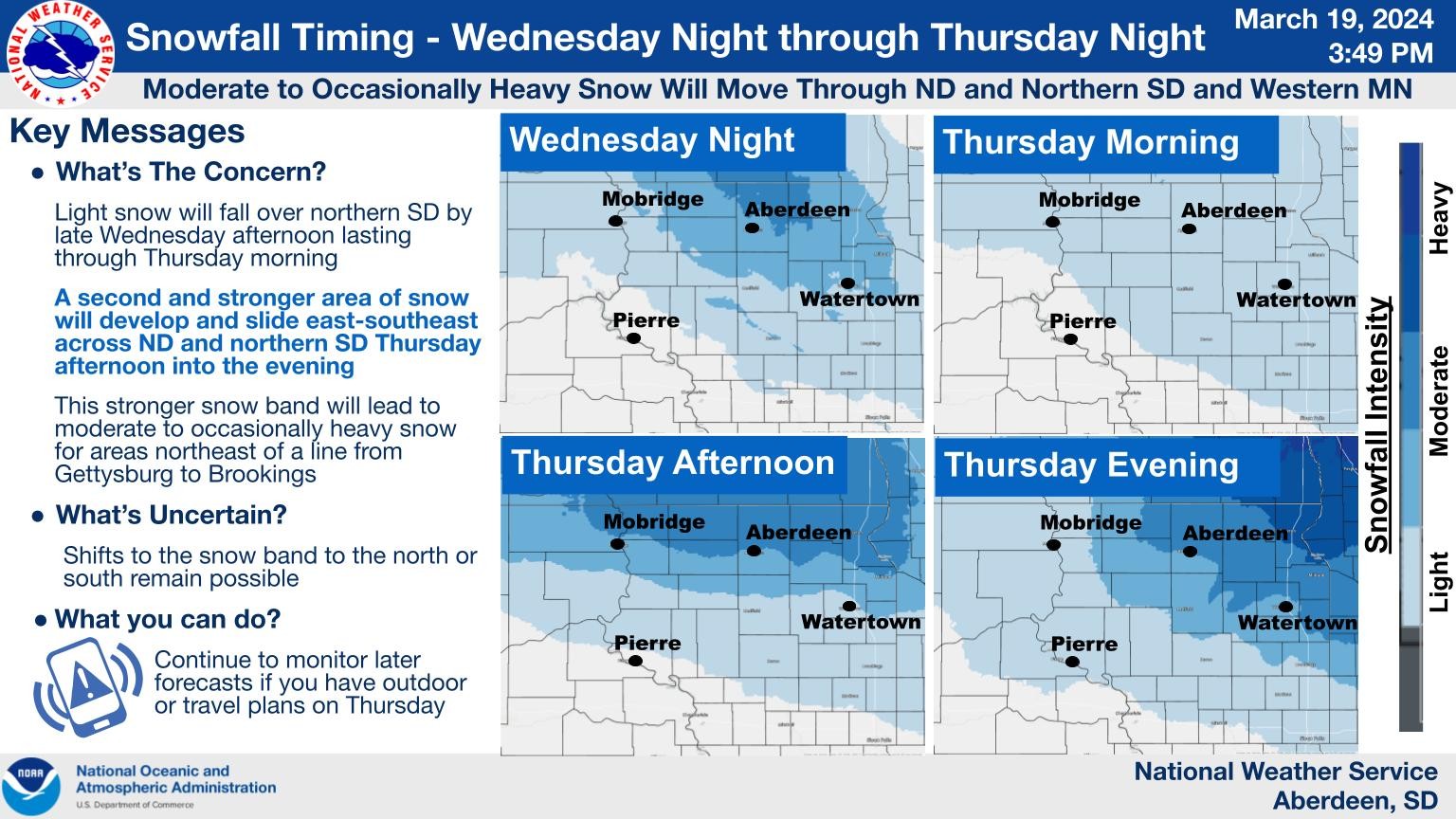
An update on some snowfall potentials. Most of the snow is expected to fall north and east of a line from McIntosh to Miller. Potentials have decreased slightly with the new forecast, but there is still a 20 to 50% chance of northeast SD receiving more than 4 inches. #SDweather
#SDwx #SDweather
192
FXUS63 KFSD 201740
AFDFSD
Area Forecast Discussion
National Weather Service Sioux Falls SD
1140 AM CST Tue Feb 20 2024
.KEY MESSAGES...
- Low (<30%) chance of patchy fog through daybreak.
- Above normal temperatures continue, perhaps rising even
further into early next week.
- Precipitation chances remain minimal with the main chance of
a sprinkle/very light precipitation late Wedn https://mesonet.agron.iastate.edu/p.php?pid=202402201740-KFSD-FXUS63-AFDFSD
#SDwx #SDweather
574
FXUS63 KUNR 201707
AFDUNR
Area Forecast Discussion For Western SD and Northeastern WY
National Weather Service Rapid City SD
1007 AM MST Tue Feb 20 2024
.KEY MESSAGES...
136 AM MST Tue Feb 20 2024
- Dry and mild conditions will persist through the week
&&
.DISCUSSION...(Today Through Monday)
Issued at 136 AM MST Tue Feb 20 2024
Current WV imagery depicts plume of upper level moisture
a https://mesonet.agron.iastate.edu/p.php?pid=202402201707-KUNR-FXUS63-AFDUNR
#SDwx #SDweather
176
FXUS63 KFSD 201122
AFDFSD
Area Forecast Discussion
National Weather Service Sioux Falls SD
522 AM CST Tue Feb 20 2024
.KEY MESSAGES...
- Low (<30%) chance of patchy fog through daybreak.
- Above normal temperatures continue, perhaps rising even
further into early next week.
- Precipitation chances remain minimal with the main chance of
a sprinkle/very light precipitation late Wedne https://mesonet.agron.iastate.edu/p.php?pid=202402201122-KFSD-FXUS63-AFDFSD
#SDwx #SDweather
379
FXUS63 KUNR 201048
AFDUNR
Area Forecast Discussion For Western SD and Northeastern WY
National Weather Service Rapid City SD
348 AM MST Tue Feb 20 2024
.KEY MESSAGES...
136 AM MST Tue Feb 20 2024
- Dry and mild conditions will persist through the week
&&
.DISCUSSION...(Today Through Monday)
Issued at 136 AM MST Tue Feb 20 2024
Current WV imagery depicts plume of upper level moisture
as https://mesonet.agron.iastate.edu/p.php?pid=202402201048-KUNR-FXUS63-AFDUNR
#SDwx #SDweather
128
FNUS63 KUNR 201003
RFDUNR
Rangeland Fire Danger Statement
National Weather Service Rapid City SD
303 AM MST Tue Feb 20 2024
.DISCUSSION...Mostly clear today with above average temperatures
in the upper 50s to low 60s. Winds will pick up across
northwestern and southwestern SD with gusts of 25 to 35 mph and
minimum RHs in northwestern and southwestern SD ranging from 30 to
40 percent.
SDZ https://mesonet.agron.iastate.edu/p.php?pid=202402201003-KUNR-FNUS63-RFDUNR
#SDwx #SDweather
076
FXUS63 KFSD 200850
AFDFSD
Area Forecast Discussion
National Weather Service Sioux Falls SD
250 AM CST Tue Feb 20 2024
.KEY MESSAGES...
- Low (<30%) chance of patchy fog through daybreak.
- Above normal temperatures continue, perhaps rising even
further into early next week.
- Precipitation chances remain minimal with the main chance of
a sprinkle/very light precipitation late Wedne https://mesonet.agron.iastate.edu/p.php?pid=202402200850-KFSD-FXUS63-AFDFSD
#SDwx #SDweather
294
CDUS43 KUNR 200839
CLIGCC
CLIMATE REPORT
NATIONAL WEATHER SERVICE RAPID CITY SD
139 AM MST TUE FEB 20 2024
...................................
...THE GILLETTE AIRPORT WY CLIMATE SUMMARY FOR FEBRUARY 19 2024...
CLIMATE NORMAL PERIOD 1991 TO 2020
CLIMATE RECORD PERIOD 9999 TO 9999
WEATHER ITEM OBSERVED TIME NORMAL DEPARTURE LAST
VALUE (LST) VALUE https://mesonet.agron.iastate.edu/p.php?pid=202402200839-KUNR-CDUS43-CLIGCC
#SDwx #SDweather
368
CDUS43 KUNR 200839
CLICUT
CLIMATE REPORT
NATIONAL WEATHER SERVICE RAPID CITY SD
139 AM MST TUE FEB 20 2024
...................................
...THE CUSTER COUNTY AIRPORT SD CLIMATE SUMMARY FOR FEBRUARY 19 2024...
CLIMATE NORMAL PERIOD 1991 TO 2020
CLIMATE RECORD PERIOD 9999 TO 9999
WEATHER ITEM OBSERVED TIME NORMAL DEPARTURE LAST
VALUE (LST) V https://mesonet.agron.iastate.edu/p.php?pid=202402200839-KUNR-CDUS43-CLICUT
#SDwx #SDweather
313
CDUS43 KFSD 200627
CLISUX
CLIMATE REPORT
NATIONAL WEATHER SERVICE SIOUX FALLS SD
1227 AM CST TUE FEB 20 2024
...................................
...THE SIOUX CITY IA CLIMATE SUMMARY FOR FEBRUARY 19 2024...
CLIMATE NORMAL PERIOD: 1991 TO 2020
CLIMATE RECORD PERIOD: 1889 TO 2024
WEATHER ITEM OBSERVED TIME RECORD YEAR NORMAL DEPARTURE LAST
VALUE (LST) VALUE https://mesonet.agron.iastate.edu/p.php?pid=202402200627-KFSD-CDUS43-CLISUX
#SDwx #SDweather
993
FXUS63 KUNR 200438
AFDUNR
Area Forecast Discussion For Western SD and Northeastern WY
National Weather Service Rapid City SD
938 PM MST Mon Feb 19 2024
.KEY MESSAGES...
1256 PM MST Mon Feb 19 2024
- Mild and dry weather will persist through the week.
&&
.DISCUSSION...(This Evening Through Monday)
Issued at 1256 PM MST Mon Feb 19 2024
Water vapor and infrared imagery show departing short https://mesonet.agron.iastate.edu/p.php?pid=202402200438-KUNR-FXUS63-AFDUNR
#SDwx #SDweather
424
FXUS63 KFSD 200438
AFDFSD
Area Forecast Discussion
National Weather Service Sioux Falls SD
1038 PM CST Mon Feb 19 2024
.KEY MESSAGES...
- Low (<30%) chance of patchy fog into Tuesday morning.
- Above normal temperatures continue, perhaps rising even
further into early next week.
- Precipitation chances remain minimal with the main chance of
a sprinkle/very light precipitation late https://mesonet.agron.iastate.edu/p.php?pid=202402200438-KFSD-FXUS63-AFDFSD
#SDwx #SDweather
230
CDUS43 KUNR 200040
CLIUNR
CLIMATE REPORT
NATIONAL WEATHER SERVICE RAPID CITY SD
540 PM MST MON FEB 19 2024
...................................
...THE EAST RAPID CITY SD CLIMATE SUMMARY FOR FEBRUARY 19 2024...
VALID TODAY AS OF 0500 PM LOCAL TIME.
CLIMATE NORMAL PERIOD 1991 TO 2020
CLIMATE RECORD PERIOD 1888 TO 2024
WEATHER ITEM OBSERVED RECORD YEAR NORMAL DEPARTURE LAST
https://mesonet.agron.iastate.edu/p.php?pid=202402200040-KUNR-CDUS43-CLIUNR
Client Info
Server: https://mastodon.social
Version: 2025.04
Repository: https://github.com/cyevgeniy/lmst