#AKfire

2025-07-03

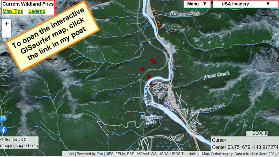
#RedFlagWarning for a large part of Alaska.

For details from NOAA - including timing - open the map, click colored area, follow the link. Since the spot you clicked might have more than one type of watch/warning, scroll down in the popup since each type of watch or warning has its own link for the details.
#AKwx #AKfire #Wildfire

Open GISsurfer map:
mappingsupport.com/p2/gissurfe

2024-06-30

#RileyFire in #Denali National Park and Preserve, Alaska.
This is burning across the Nenana River from the park village.

Map shows heat detections from MODIS and VIIRS satellites. Locations are approximate and not real time. #AKfire #Wildfire #AlaskaWX

Open GISsurfer map:
mappingsupport.com/p2/gissurfe

2023-08-07

Interactive #GIS map showing MODIS and VIIRS *heat* detections. Dark red is a detection within prior 6 hours.

This data only shows approximate locations, is not real time and sometimes is ‘false positive’. To learn more click “Map tips” upper left corner and read about MODIS and VIIRS.
#AKfire #AKwx #CanadaFire #NWTfire #Geospatial #Maps #Mapping #Leaflet #ArcGIS #WebMap

Open #GISsurfer map:
mappingsupport.com/p2/gissurfe

Client Info

Server: https://mastodon.social
Version: 2025.07
Repository: https://github.com/cyevgeniy/lmst