TIL OpenStreetMap has documentation about best practices when organising organised editing runs https://osmfoundation.org/wiki/Organised_Editing_Guidelines
Contributed my first edit to add some co-working cafes around #Taipei
TIL OpenStreetMap has documentation about best practices when organising organised editing runs https://osmfoundation.org/wiki/Organised_Editing_Guidelines
Contributed my first edit to add some co-working cafes around #Taipei
A small taste of "Hidden Order" by United Visual Artists at Casa Batllo last night.
#Barcelona #mapping
Maps Mania: Meet Language Explorer: Google’s New Open-Source Linguistic Atlas. “Google Research’s Language Explorer, is a new interactive map that anyone can use to explore the world’s languages.”
https://rbfirehose.com/2026/01/31/meet-language-explorer-googles-new-open-source-linguistic-atlas-maps-mania/So guckt das übrigens aus (meine lieblings fragen sind natürlich schon weniger)
3/3


In 5 days, @esri #Water webinar: #GIS Methods, Tools, and Workflows for Water #Resources https://tinyurl.com/4ks9vn74
#hydrology #watershed #flood #management #GIS #esri #arcgis #mapping #GISchat #geospatial @esrislgov @esritraining @urisa

Today's the day for #MappingUSA! Check your inbox for the Zoom invite link. We kick off at 2 pm ET.
Forgot to register? Do it quick here: https://openstreetmap.app.neoncrm.com/np/clients/openstreetmap/eventRegistration.jsp?event=184&

Earth MRI Acquisitions Viewer [#USGS]
--
https://ngmdb.usgs.gov/emri/ <-- shared online mapping resource
--
https://www.usgs.gov/special-topics/earth-mri <-- shared #USGS #EarthMRI home page
--
[wonderful #USGS #fedscience work!]
"Earth MRI is modernizing mapping of the Nation's surface and subsurface. We deliver high-quality data needed to understand our Nation's geology, find new critical and other mineral resources, and inform decisions about how the Nation will meet its evolving needs..."
#criticalminerals #criticalmineralsdata #hyperspectral #geologicmapping #resourceassessments #GIS #spatial #mapping #geology #opendata #minerals #mining #technology #EarthMRI #MRI #MappingResourceInitiative
@USGS


Nominations for the OSM US Board of Directors are open! If you are looking for a way to get involved in the open source mapping community, here's your chance!
Get all the details in this blog post: https://openstreetmap.us/news/2026/01/board-elections/
Check out the elections wiki for more: https://wiki.openstreetmap.org/wiki/Foundation/Local_Chapters/United_States/Elections/2026
Deadline: Feb. 8
#OpenStreetMap #OSM #nonprofit #boardservice #opendata #mapping #geospatial #GIS

Maps Mania: The Giant Pixel Art Map of New York. “Isometric NYC is a huge pixel art map of New York City – and I mean huge. Anyone who lives in, or knows NYC can spend hours exploring this map, zooming in on their favorite neighborhoods, streets, and landmarks, all reimagined in a classic old-school pixel art style.”
https://rbfirehose.com/2026/01/29/maps-mania-the-giant-pixel-art-map-of-new-york/See The Mississippi River’s Hidden History, Uncovered By Lasers
Using hyperprecise LiDAR data,. a cartographer [well, hydrographer!] maps the river’s bend and channels over time with mesmerizing results…
--
https://www.nationalgeographic.com/science/article/mississippi-rivers-hidden-history-uncovered-by-lidar <-- shared technical / media article
--
https://dancoecarto.com/ <-- shared @Daniel Coe portfolio and more
--
https://usace.contentdm.oclc.org/digital/collection/p266001coll1/id/10015/ <-- shared Harold Fisk's 1944 USACE report, “The Alluvial Valley of the Lower Mississippi River”
--
#GIS #spatial #mapping #water #hydrography #hydrology #LiDAR #remotesensing #spatialanalysis #spatiotemporal #hydrogeomorphology #Mississippi #River #Fiske #cartography #visualisation #meandering #channels #landforms #floodplains #opendata #3DEP #topography #geomorphology #levees #dikes #oxbows #channel #paleohydrology
#DanielCoe | @nationalgeographic | #USGS | #USACE


Mapping Medieval Africa - The Great Kingdoms of the West
--
https://ubiqueags.org/the-ags-globe-mapping-medieval-africa-the-great-kingdoms-of-the-west/ <-- shared technical article
--
https://www.historyextra.com/period/medieval/medieval-west-africa-history-facts/ <-- shared technical article
--
https://www.amazon.com/Medieval-West-Africa-Nehemia-Levtzion/dp/1558763058# <-- shared link to book
--
H/T #AmericanGeographicalSociety
“Medieval West Africa was dominated by three great empires - Ghana, Mali, and Songhai - that grew immensely powerful from the trans-Saharan trade routes, especially for gold and salt, fostering vibrant Islamic cultures, wealthy cities like Timbuktu, and powerful centralized governments before smaller states emerged. These empires were centers of learning, art, and distinct governance, with oral traditions preserving much of their history…”
#mapping #historicmaps #Africa #WestAfrica #Medieval #cartography #empires #kingdom #Ghana #Mali #Songhai #trading #traderoutes #Sahara #gold #salt #Timbuktu #history
@AmericanGeographicalSociety


Remote Sensing and GIS Assessment of Drought Dynamics in the Ukrina River Basin, Bosnia and Herzegovina
--
https://doi.org/10.3390/atmos17020124 <-- shared paper
--
#GIS #spatial #mapping #drought #risk #hazard #remotesensing #MODIS #satellite #earthobservation #spatialanalysis #spatiotemporal #monitoring #Ukrina #RiverBasin #Bosnia #Herzegovina #BosniaHerzegovina #water #waterresources #socioeconomic #risk #hazard #cost #economics #agriculture #foodsecurity #watersecurity #landcover #vegetation #croplands #fruit #crops #metrology #hydrology #droughtexposure #basins #riverbasins #watersheds #monitoring #mitigation #planning #droughtrisk


Suunto’s New Route Planner Is Free and Awesome
https://squeet.me/display/962c3e10-9ed4d895-dec52f661722ce58
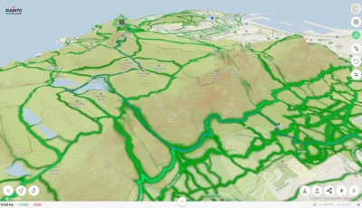
Suunto’s New Route Planner Is Free and Awesome
“Something you don’t see every day: a sports tech company actually giving away premium features for free. Suunto’s route-planning tool lets you create and download GPX files without even creating an account. No paywall, no trial period—just open the ...continues
See https://gadgeteer.co.za/suuntos-new-route-planner-is-free-and-awesome/
#Planet #Earth as a rotating cube, animated and lit using just 3kb of #HTML, #CSS and #Javascript.
https://www.thomasweibel.ch/earthcube/
#worldmap #map #mapping #geography #gis #topography #opendata #opensource #openglam #glamhack #digitalhumanities #astronomy #space #webdev @spatialists @OpendataCH
Playing around with a "purple map" of the 2025 US presidential election, starting with just #NewMexico. It's fun to see how the numbers change across my local small town, which areas voted more Republican vs. more Democrat. I used #Python and #Folium to make the #map.
https://shallowsky.com/blog/programming/2024-election-purple-map.html

#ArcGIS Field #Maps: Quick Start Guide for Tasks https://tinyurl.com/yjrnt4mh
#FieldOperations #mobile #GIS #DataCollection #esri #mapping #ArcGISApps @esri @esrislgov @arcgisapps @esritraining @urisa

Earth's Magnetic Shield Protecting The Planet From A Pelting By The Solar Wind
See how the sun's energy drives a remarkable planetary engine, the climate
--
https://youtu.be/6hD52H7rQak?si=OBGYbK8Czbi0uwlc <-- shared video
--
[‘cannibalising’ (sic) my own post (!) to bring attention to this outstanding video visualisation and overview, science education/explanation at its finest!; narrated so well (of course!) by #liamneeson !!]
#GIS #spatial #mapping #geology #structuralgeology #magneticfield #SouthAtlanticAnomaly #SAA #spaceweather #geomagnetism #risk #hazard #hardening #magneticfieldstrength #protection #CME #coronalmassejection #sun #solar #solarwind #visualisation #visualization #education #scienceeducation #overview #explanation
#NASA