#Gdal

Michael Sumnermdsumner@rstats.me
2025-06-20

#GDAL is there a way to specify an empty raster source entirely as a text string (compactly)?

I can use MEM and generate a datapointer description from an array in memory, but what about the equivalent of an empty cog? something like

"MEM:::EMPTY_COG,87,61,1,Float64,0/1/0/61/0/-1"

(I certainly don't recommend experimenting with arbitrary values for DATAPOINTER)
2025-06-18

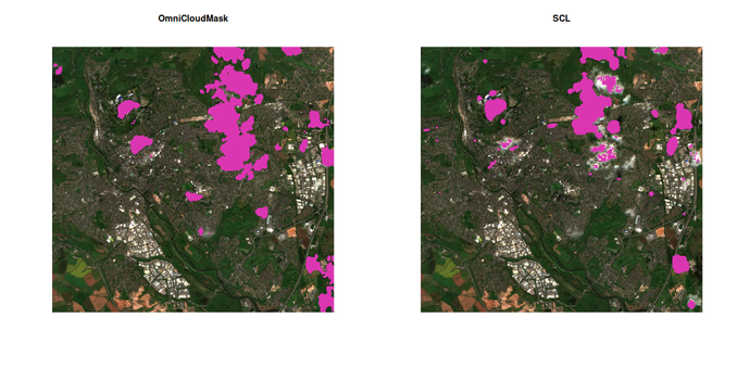
Ooh CNN-based cloud masking baked right into a VRT file. This should be fun! #rstats #rspatial #gdal #python

This is using github.com/DPIRD-DMA/OmniCloud and appears to be a massive improvement on the standard Sentinel 2A SCL band!

2025-06-17

@MichaelTBacon @eliocamp here it seems #Rspatial is innocent, #GDAL error is helpful here.

2025-06-07

GDAL modernization webinar and FAQ: The #GDAL Project Steering Committee recently hosted a webinar highlighting the major #modernization of the GDAL command-line interface, featuring the unification of commands and improved parameter consistency. You can now catch up on all the...
spatialists.ch/posts/2025/06-0 #GIS #GISchat #geospatial #SwissGIS

2025-06-04

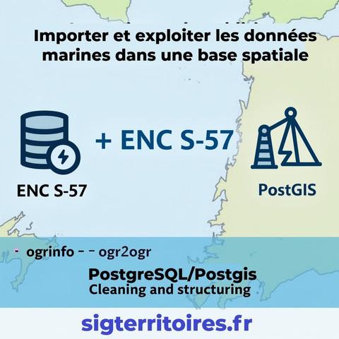
๐Ÿ†• New technical article (in English): Efficient workflow to load and explore ENC (S-57) nautical charts in PostGIS and QGIS.

๐Ÿ” Overview of the S-57 format structure
โš™๏ธ Automated import with ogr2ogr and batch scripts
๐Ÿงฉ PostGIS optimization: triggers, stored procedures & indexing
๐Ÿ—บ๏ธ QGIS-ready in minutes for fast cartographic exploration

๐Ÿ“˜ Read the article here ๐Ÿ‘‰sigterritoires.fr/index.php/en

#QGIS #PostGIS #S57 #ENC #GeoSpatial #MarineGIS #ogr2ogr #GDAL

Michael Sumnermdsumner@rstats.me
2025-06-03

Upcoming #GDAL cli modernization webinar, free registration (it's 2pm UTC, in 4.3 hours from now)

discourse.pangeo.io/t/webinar-

Damien Ayers ๐Ÿ‡ฆ๐Ÿ‡บ ๐Ÿง—omad@fosstodon.org
2025-06-02

@EvenRouault Look out #numpy, #GDAL is coming for you! ๐Ÿ˜

Even RouaultEvenRouault
2025-06-02

Quite excited by the new artihmetic band on-the-fly capabilities of github.com/OSGeo/gdal/pull/125

```python
with gdal.Open("rgb.tif") as ds:
R = ds.GetRasterBand(1)
G = ds.GetRasterBand(2)
B = ds.GetRasterBand(3)
gray = (0.299 * R + 0.587 * G + 0.114 * B).as_type(gdal.GDT_Byte)
gdal.GetDriverByName("GTiff").CreateCopy("gray.tif", gray)
```

Even RouaultEvenRouault
2025-05-29

Fun contest. Craft the smallest file (in terms of byte size) that is recognized (opened by GDAL, using any official driver of your choice) with 2147483647 x 2147483647 raster size. My current record is 27 bytes. Any improvement over that?

2025-05-27

Does GDAL have an option to throttle the rate of http requests? #gdal #rspatial

2025-05-25

With 'gdal raster calc' we can perform pixel-wise calculations on raster data. I am wondering if we could somehow also perform calculations on neighboring pixels?
To calc e.g. slope, focal min, ...
@EvenRouault #gdal

2025-05-23

If you need the latest dev versions of #gdal and #gdalraster for #rstats #rspatial development I made a docker file for that ๐Ÿ™‚:

github.com/h-a-graham/gdal-r-d

Michael Sumnermdsumner@rstats.me
2025-05-23

Kicked off a HPC job, 64 CPUs, converting global 11 variable netcdf to single var cog, from and to the local object storage.

There's 120K files to be created, and 20 minutes or so in it's up to 37K done, each is 2880x1440, Int32 (zstd, predictor 2)

Blows my mind how fast stuff is when obstacles and complications are removed
...thanks to #GDAL
and #rstats {gdalraster}, and {mirai} via {purrr}

geoObservergeoObserver
2025-05-16

GDAL: Ab v3.11 alternativ auch als neues einzelnes Programm / From v3.11 alternatively also as a new single programm geoobserver.de/2025/05/16/gdal @GdalOrg @EvenRouault pls RT

๐Ÿ’ง๐ŸŒ Greg CocksGregCocks@techhub.social
2025-05-15

โ€œEvery new geospatial tool is just GDAL in a trench coatโ€
~ @lindsey Nield of @earthmover
H/T @hobu
#GIS #spatial #mapping #GDAL #opensource #spatialanalysis #tool

Javier Jimenez Shawjjimenezshaw@mapstodon.space
2025-05-14

What do you think a is "GByte"?

You can discuss if it is 1000ยณ or 1024ยณ bytes...

but for @gdal it is... one byte! (I assume the G is from #GDAL ) But my brain cannot stop thinking in giga-bytes while reading that code.

More exactly it is defined as
`typedef unsigned char GByte;`

2025-05-12

GDAL 3.11 released with new gdal program: As of Friday, #GDAL 3.11.0 โ€œEganvilleโ€ has been released. Starting with GDAL 3.11, parts of the GDAL utilities are available from a new single gdal program which accepts commands and subcommands. This simplifies and unifies GDAL syntax.
spatialists.ch/posts/2025/05-1 #GIS #GISchat #geospatial #SwissGIS

2025-05-12

R package gdalraster 2.0 released on CRAN. This version adds bindings to the GDAL Vector API along with other new features and improvements.

Release notes: github.com/USDAForestService/g

#rspatial #gdal

Client Info

Server: https://mastodon.social
Version: 2025.04
Repository: https://github.com/cyevgeniy/lmst