Global Coffee Report: ICO relaunches Coffee Sustainability Support Database. “The new platform features interfaces with intuitive dashboards, including a dedicated Country View and Project View. According to the ICO, C2SD serves as a centralised public resource to improve access to information on more than 400 sustainability projects in coffee-producing countries.”
#mapping
I would like to invite everyone to my colleague's webinar next Tuesday where she will talk about how we - #ABMI - are #mapping #wetlands with variable water extents https://us02web.zoom.us/meeting/register/mFYs1LaSRKWmxz36JI4VWA?mc_cid=db0db659ab&mc_eid=94959c25d3#/registration
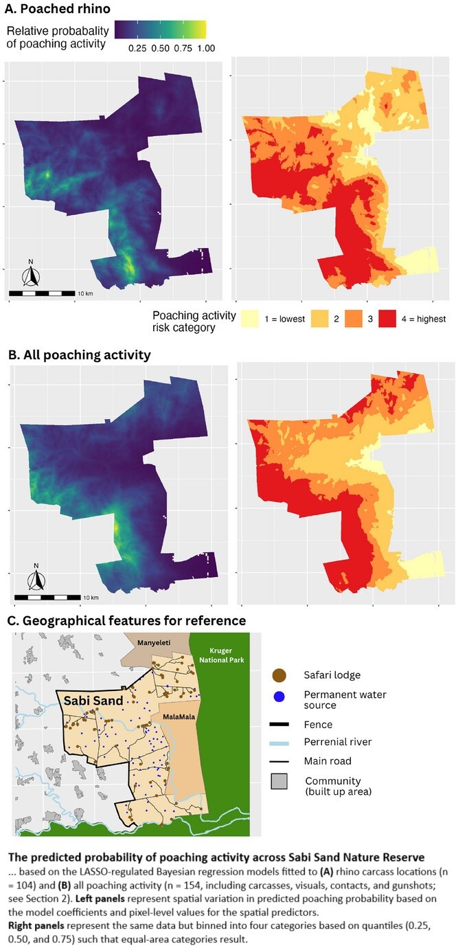
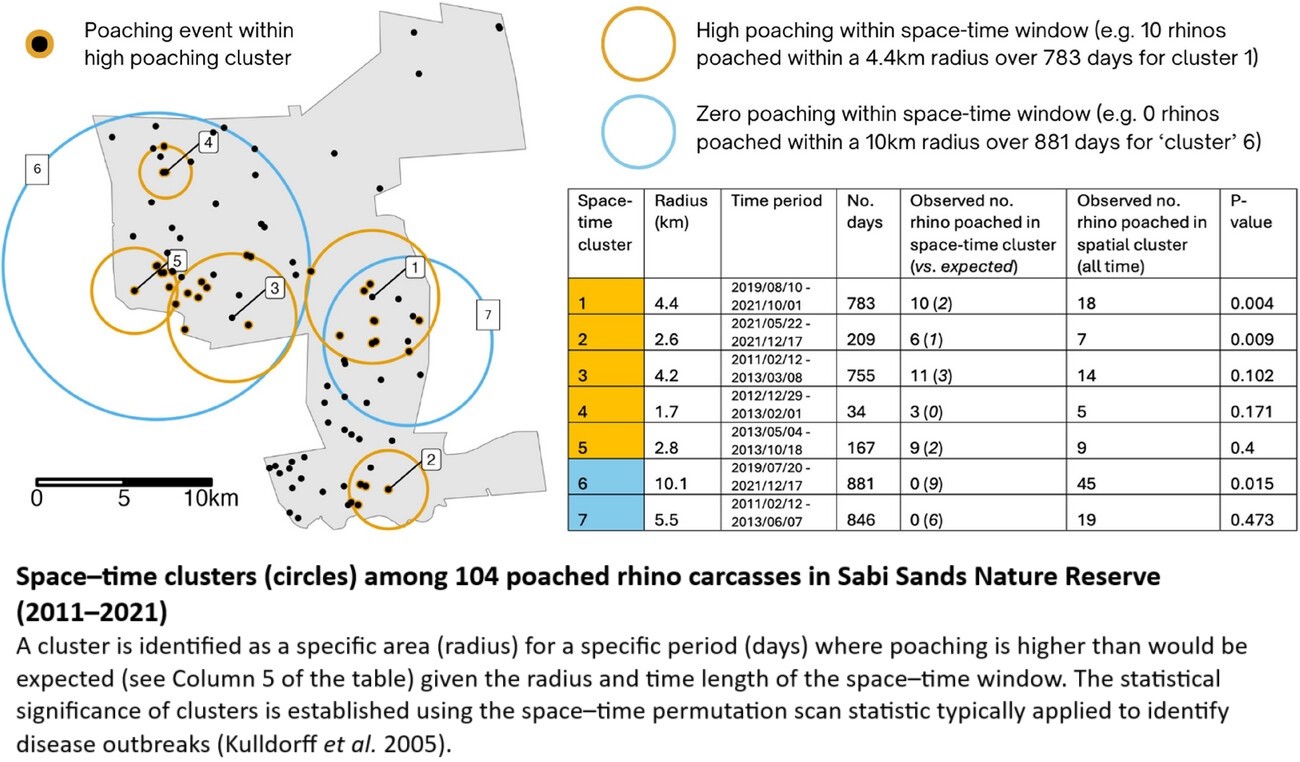
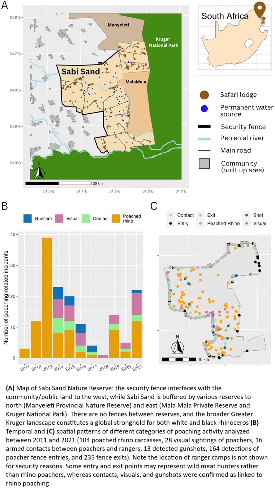
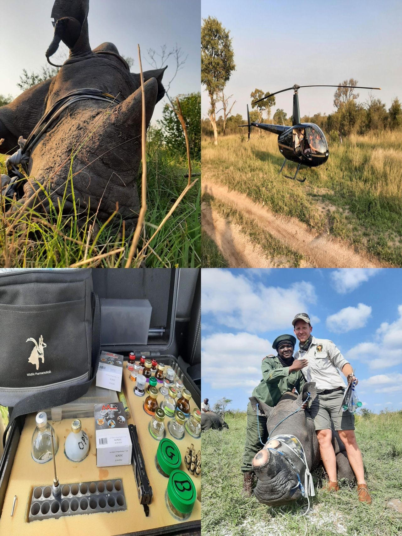
Colluding Rhino Poachers Exploit Space–Time Variation In Opportunity And Risk
--
https://doi.org/10.1111/conl.13106 <-- shared paper
--
“[R]esearch analysing over 500 rhino poaching incidents and exploring what these patterns reveal about the behaviours of poachers, rangers, and rhinos. [Their] study highlights concerning evidence of criminal syndicate infiltration, space–time targeting by poachers, and how behavioural insights can inform effective responses—from targeted dehorning to bolstering ranger resilience…”
#GIS #spatial #mapping #spatialanalysis #wildlifeconservation #wildlife #conservation #statistics #geostatistics #rhino #rhinohorn #rhinoceros #poaching #rangers #criminal #syndicate #mafia #criminalsyndicate #activity #crime #illegal #behaviour #dehorning #rangerstation #protection #humanimpacts #ecosystem #habitat #deterrencetheory #deterrence #methodology #tourist #tourism #reserve #spatiotemporal #opportunity #risk #hazard #riskassessment #Africa #SouthAfrica #alldataisspatial
@Sabi Sand Nature Reserve
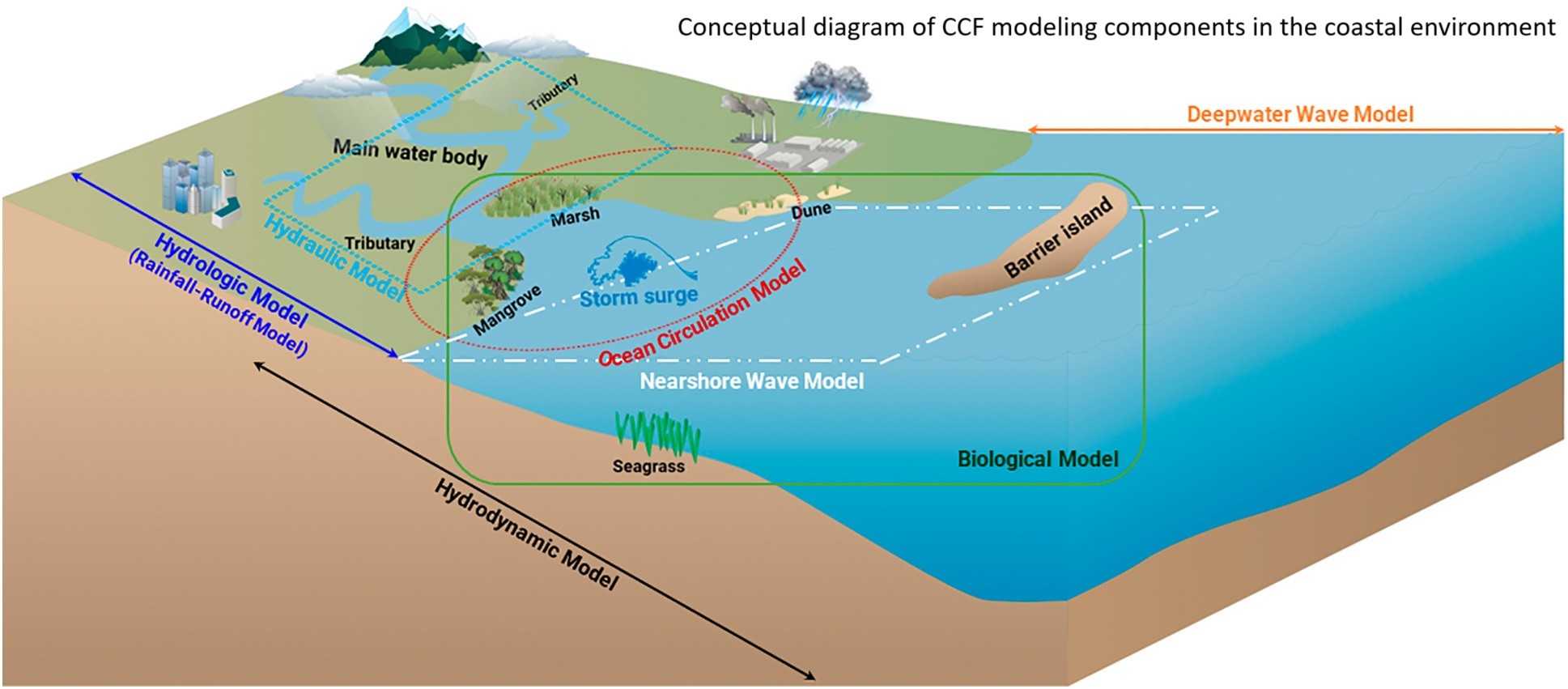
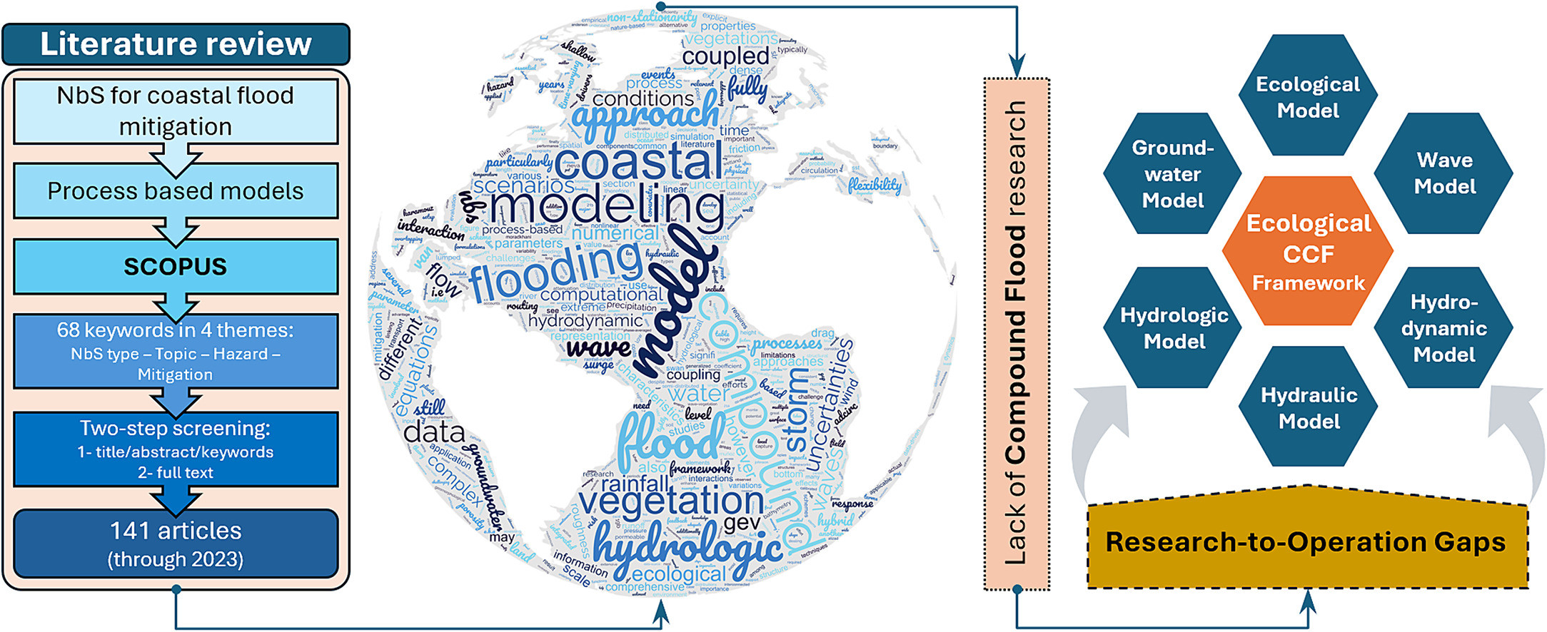
Advancing Compound Flood Modeling to Evaluate Coastal Protection Benefits of Natural Infrastructure
--
https://coastalscience.noaa.gov/news/advancing-compound-flood-modeling-to-evaluate-coastal-protection-benefits-of-natural-infrastructure/ <-- shared technical article
--
https://doi.org/10.1016/j.scitotenv.2024.173529 <-- shared paper
--
#flood #flooding #literaturesearch #compilation #coast #coastal #coastalengineering #mitigation #planning #management #framework #model #modeling #infrastructure #natural #barrier #rainfall #precipitation #climatechange #river #discharge #stormsurge #sealevel #seallevelrise #waves #tides #compoundflooding #humanimpacts #communities #publicsafety #cost #loss #economics #fedscience #fedservice #hydrology #water #marine #ocean #hydraulic #hydrodynamic #biology #ecosystems #vegetation #sedimentation #erosion #GIS #spatial #mapping #spatialanalysis #regional #local #forecasting #preparation #enduser #usecase #publicwarnings #marsh #sawmp #mangrove
@NOAA | @NOAA Ocean | @NOAA Centers for Coastal Ocean Science

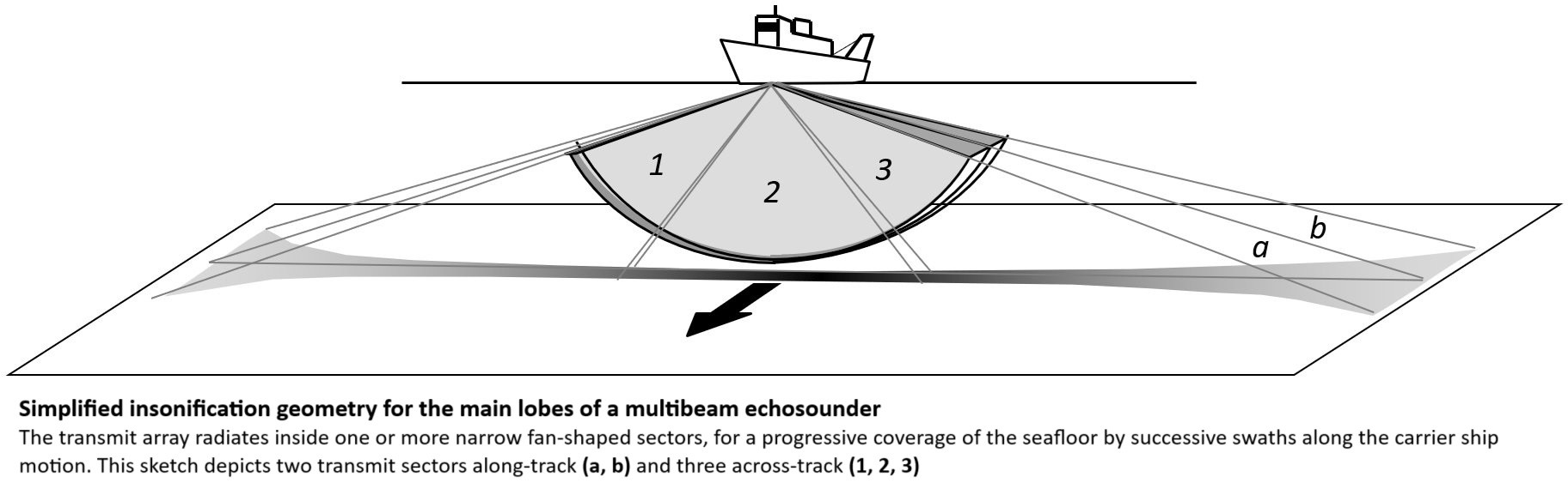
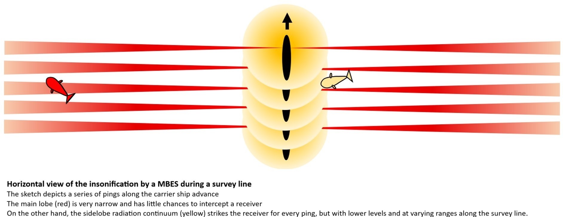
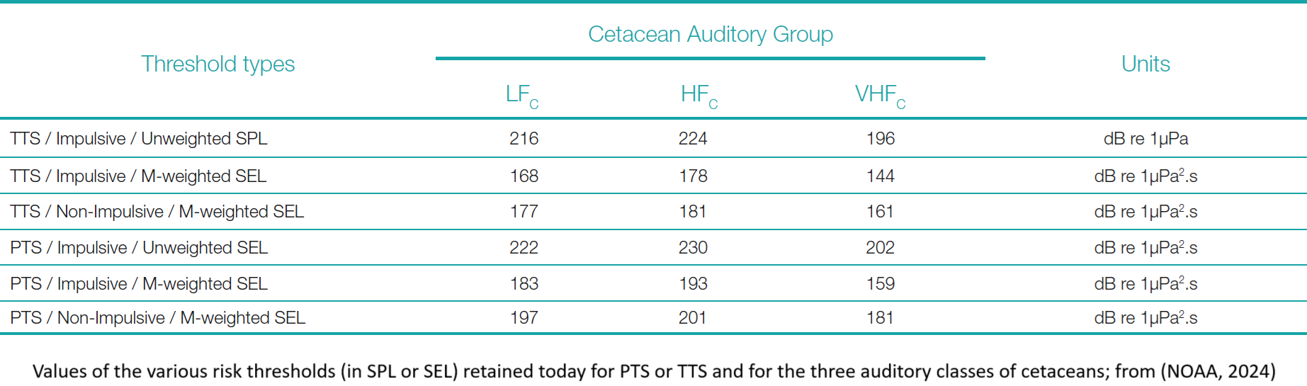
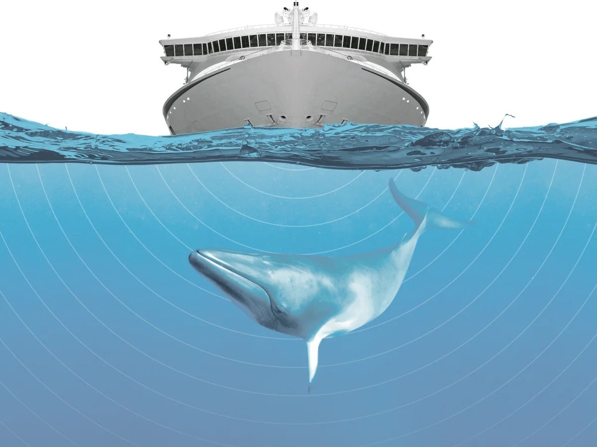
Towards A Simpler Assessment Of The Environmental Impact Of Hydrographic Echosounders
--
https://ihr.iho.int/articles/towards-a-simpler-assessment-of-the-environmental-impact-of-hydrographic-echosounders/ <-- shared paper
--
https://www.fisheries.noaa.gov/s3/2024-05/NMSFAcousticGuidance-DraftTECHMEMOGuidance-3.0-FEB-24-OPR1.pdf <-- shared NOAA 2024 guidance
--
https://doi.org/10.1098/rspb.2020.0070 <-- shared paper
--
#GIS #spatial #mapping #communityhydrography #echosounder #environmentalimpact #hydrography #marinemammals #whales #cetaceans #survey #impacts #humanimpacts #logistics #management #planning #ecosystems #seafloor #sonar #remotesensing #marine #animals #risk #hazard #multibeam #model #modeling #impactassessment #riskassessment #auditory #fish #habitat #strandings
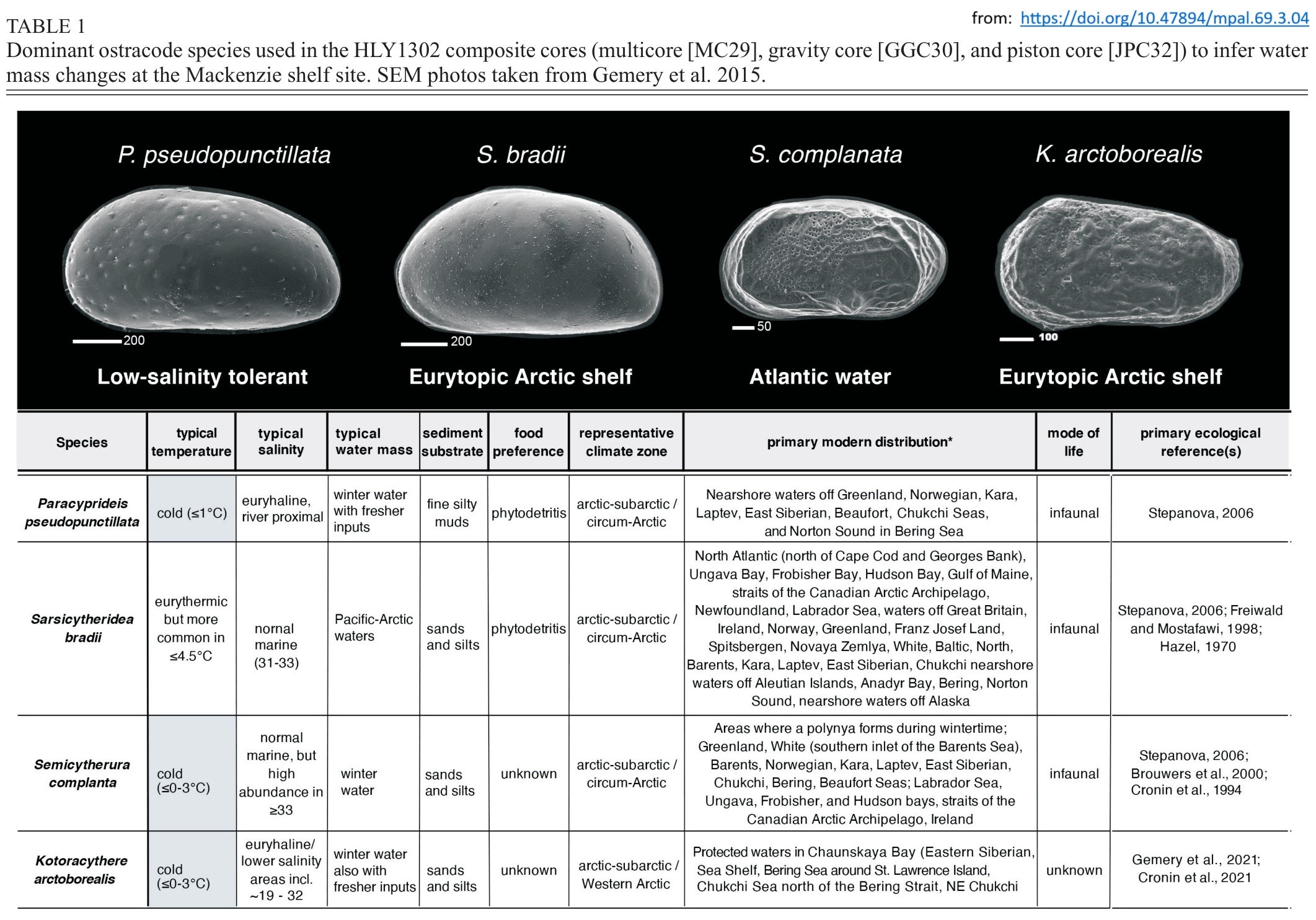
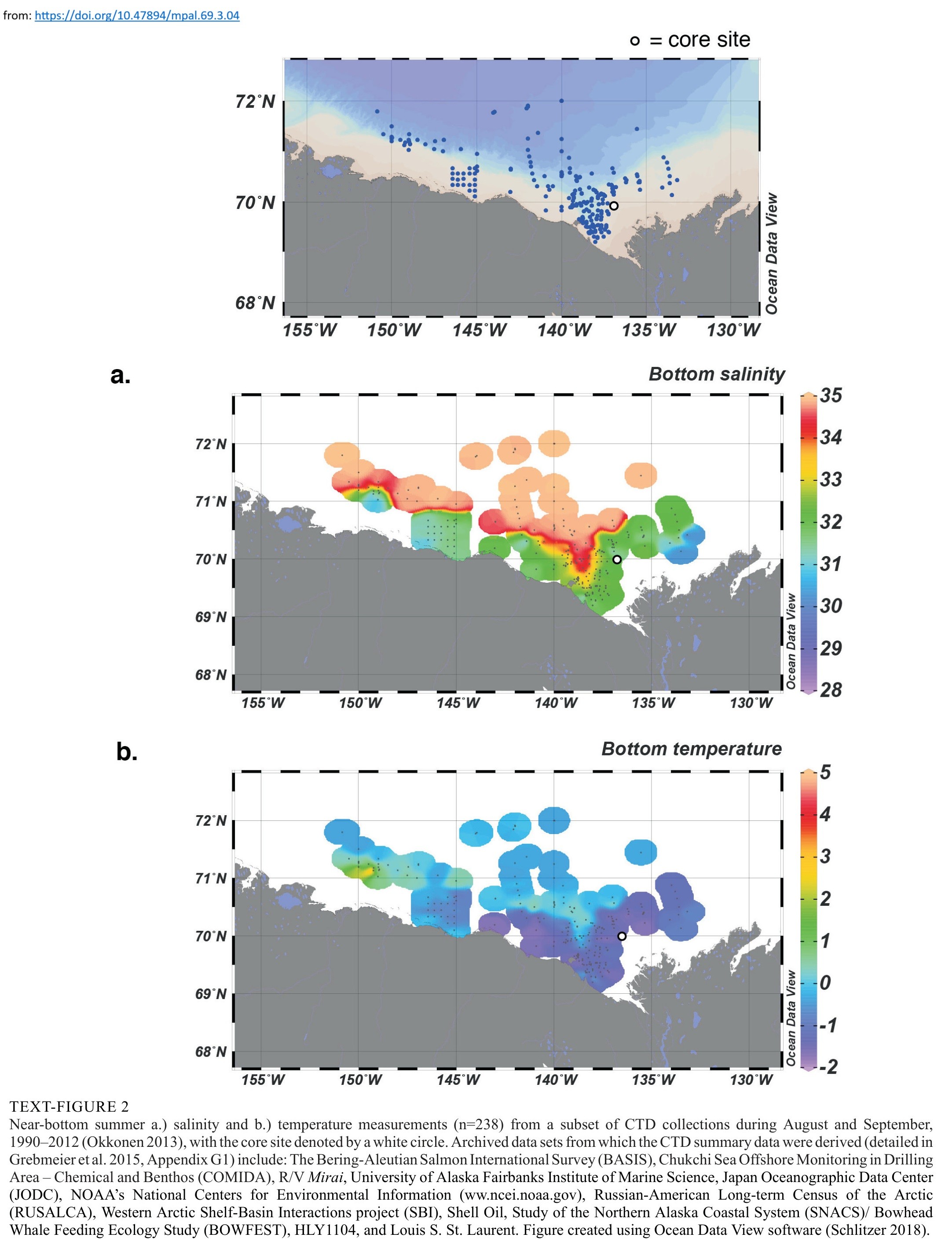
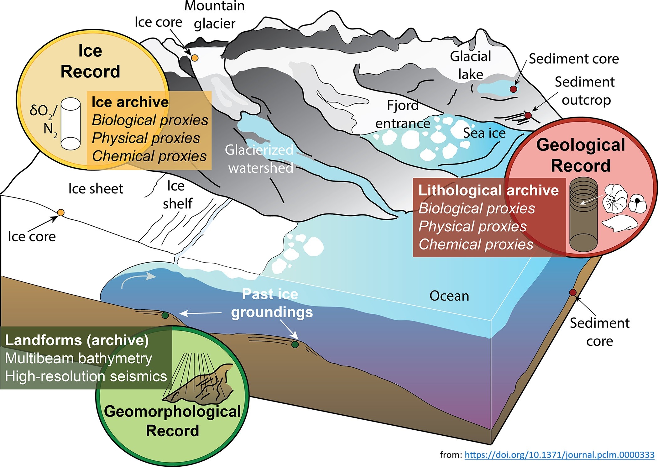
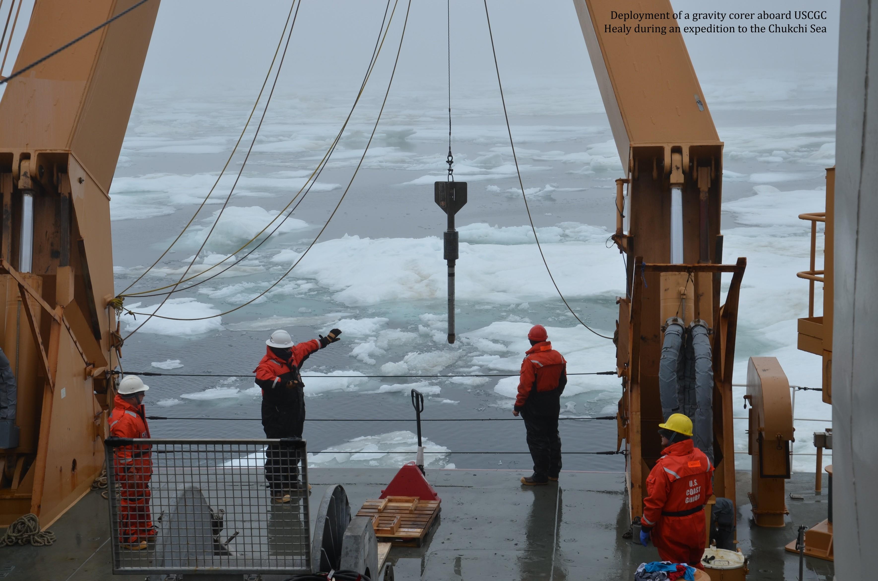
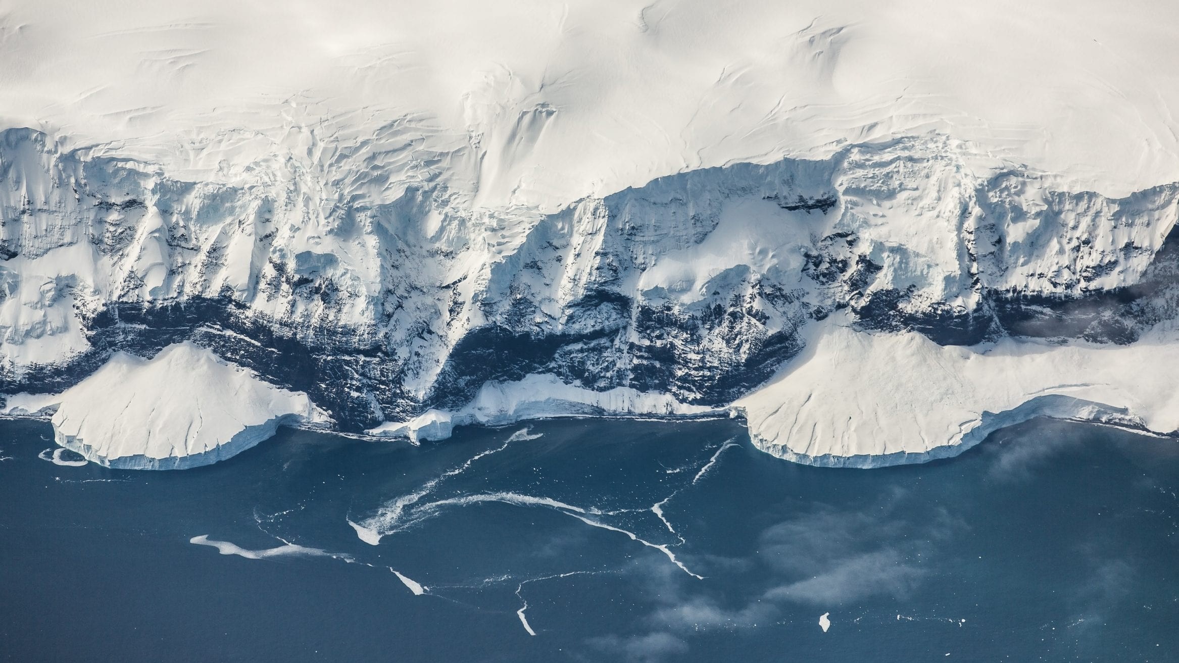
Land-Sea Linkages In The Arctic – What Is Paleoclimatology?
--
https://www.usgs.gov/programs/ecosystems-land-change-science-program/science/land-sea-linkages-arctic <-- shared technical article
--
https://doi.org/10.1371/journal.pclm.0000333 <-- shared example of paper
--
https://doi.org/10.47894/mpal.69.3.04 <-- shared example of paper
--
[who doesn’t like a good foraminifera! (memories of staring down a microscope for hours at grad school) 😊 ]
#fedscience #Paleoclimatology #Paleoecology #Paleooceanography #Icesheet #climatechange #Paleoanthropology #Seaice #Marineecosystems #GIS #spatial #mapping #spatialanalysis #model #modeling #spatiotemporal #foraminifera #arctic #change #cryosphere #ArcticOcean #glacial #interglacial #Holocene #future
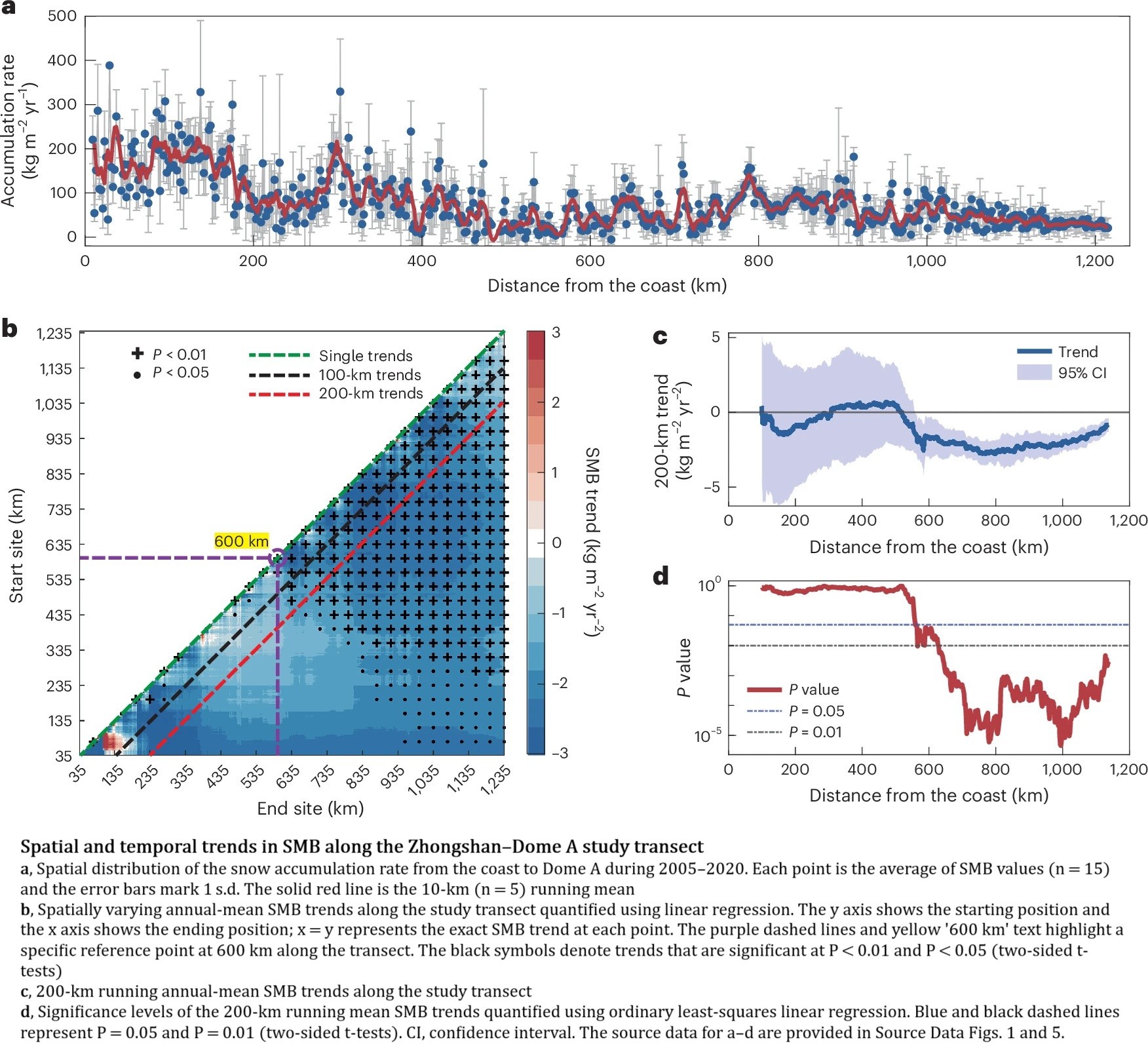
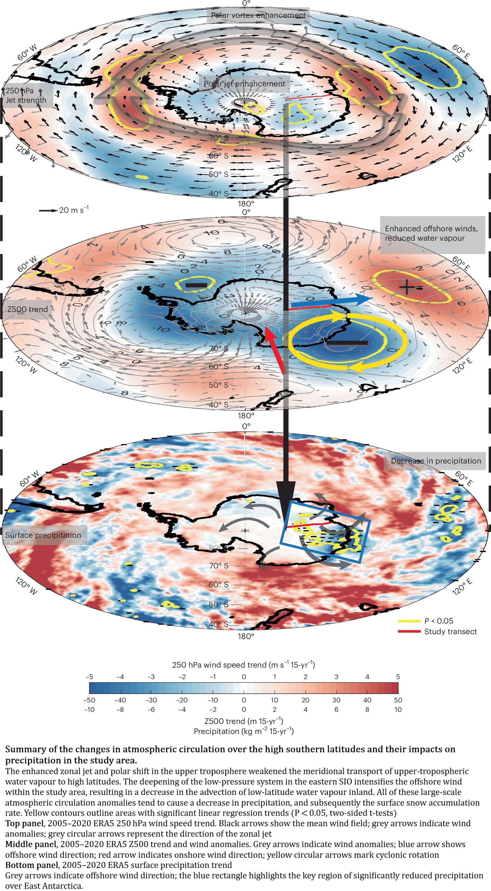
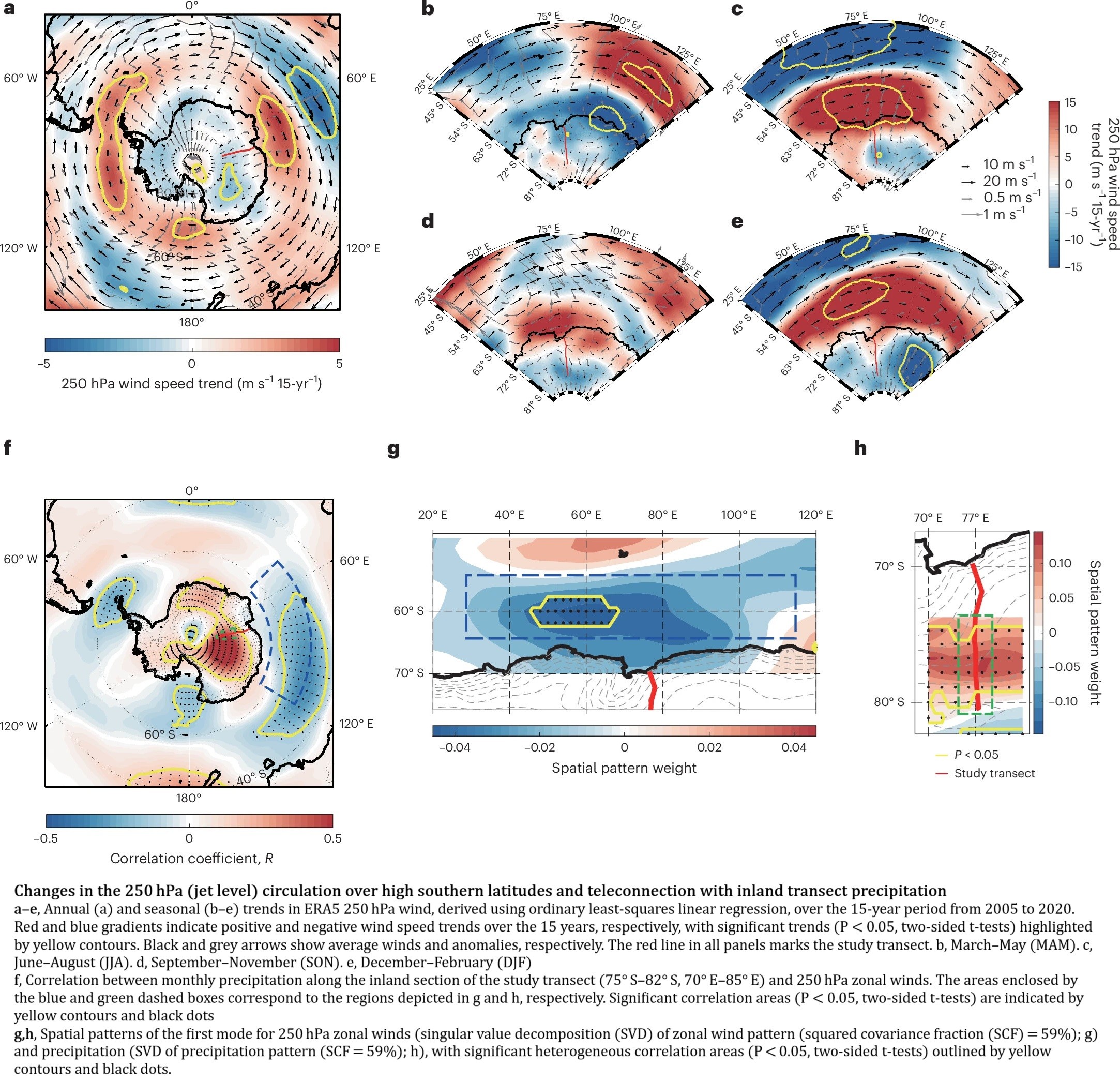
Sustained Decrease In Inland East Antarctic Surface Mass Balance Between 2005 And 2020
--
https://doi.org/10.1038/s41561-025-01699-z <-- shared paper
--
#GIS #spatial #mapping #Antarctic #EastAntarctic #icesheet #massbalance #spatialanalysis #model #modeling #spatiotemporal #water #climate #climatedynamics #monitoring #remotesensing #earthobservation #icecore #snowpit #wind #melting #water #ice #science #cryology #snow #weather #watervapour #climatemodel
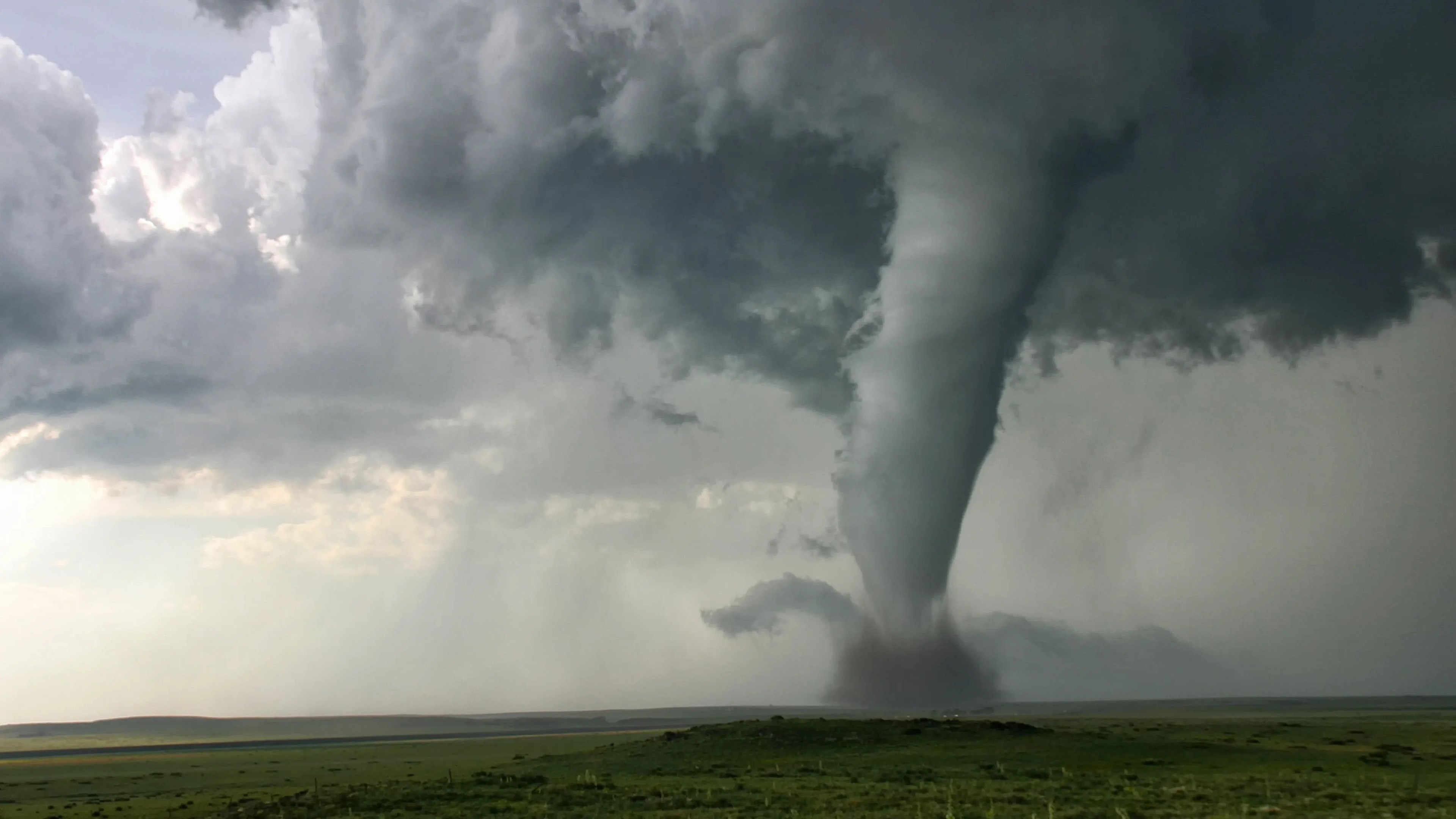
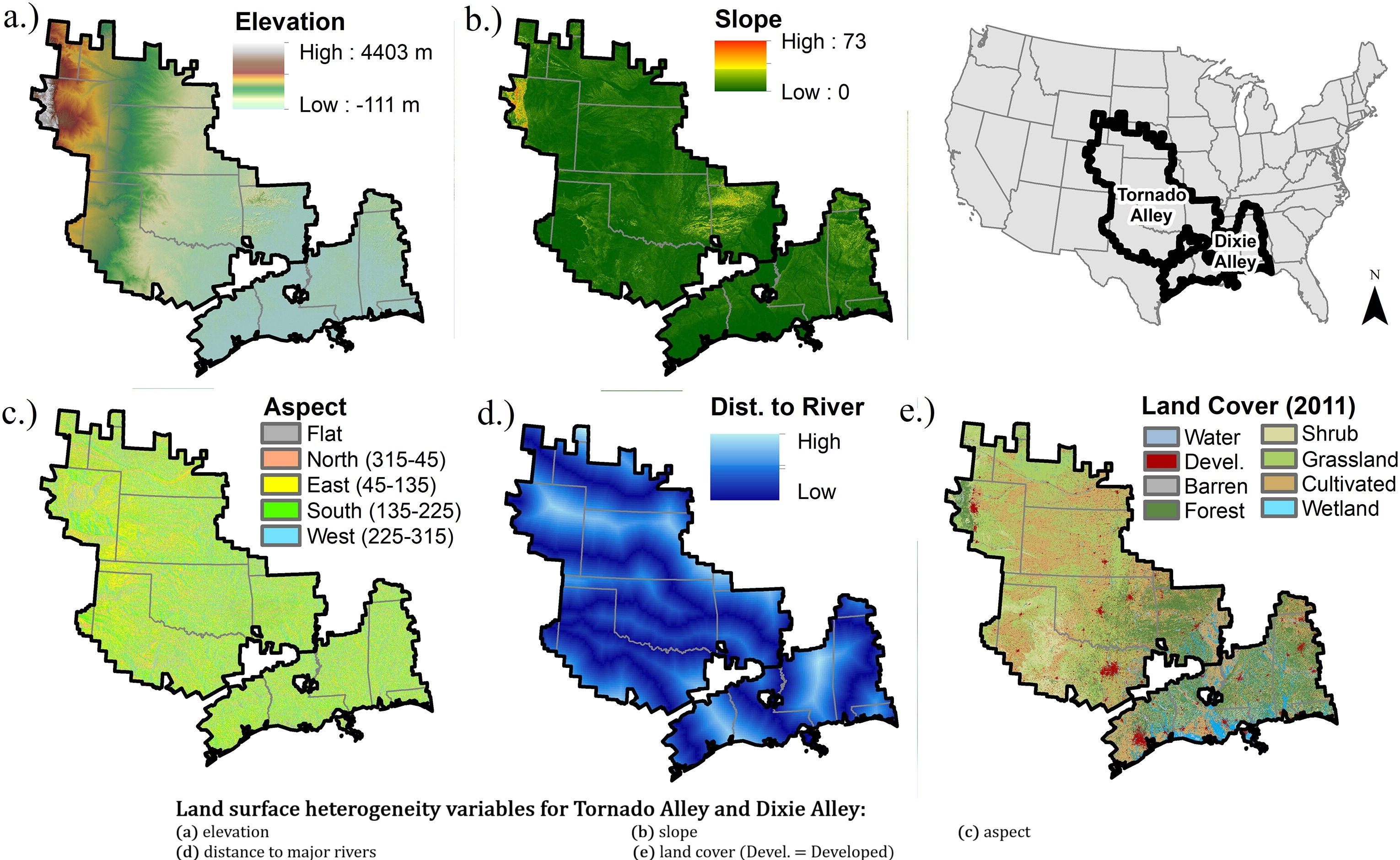
Land Surface Heterogeneity And Tornado Occurrence - An Analysis Of Tornado Alley And Dixie Alley
--
https://doi.org/10.1080/19475705.2019.1583292 <-- shared paper
--
#GIS #spatial #mapping #NLCD #climatechange #severeweather #extremeweather #environment #slope #remotesensing #landcover #extremeweather #landcover #landuse #tornado #risk #hazard #damage #cost #economics #publicsafety #infrastructure #loss #USA #TornadoAlley #DixieAlley #landsurface #topography #vegetation #spatialanalysis #model #modeling #heterogeneity #variables #parameters #factors #geostatistics #statistics #EROS #fedscience

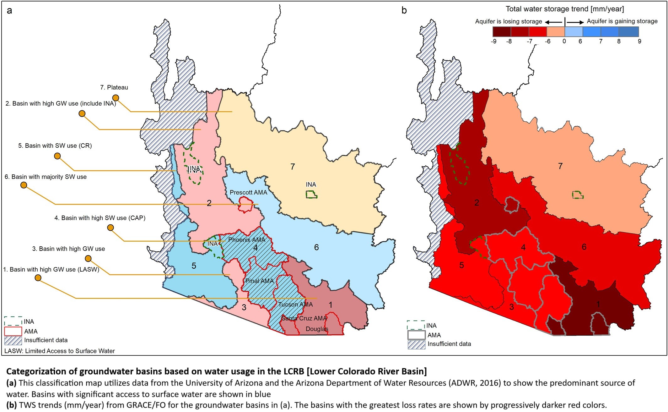
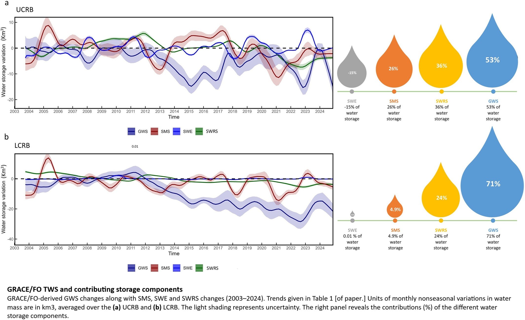
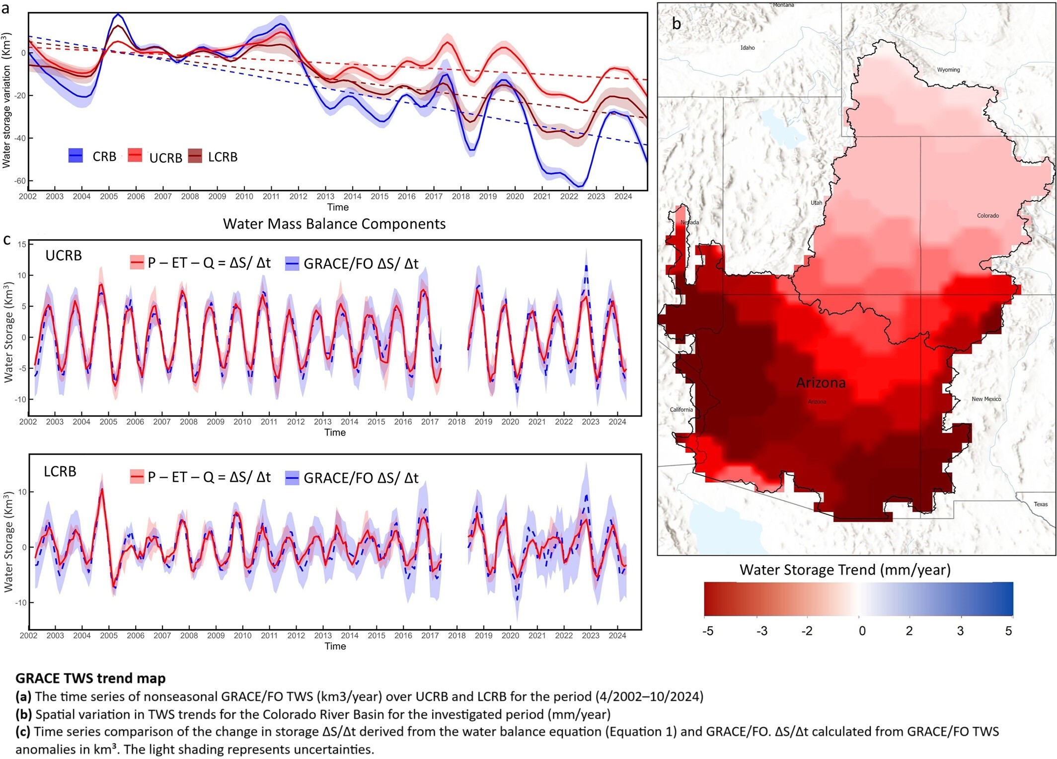
Declining Freshwater Availability in the Colorado River Basin Threatens Sustainability of Its Critical Groundwater Supplies
--
https://doi.org/10.1029/2025GL115593 <-- shared paper
--
https://www.livescience.com/planet-earth/rivers-oceans/groundwater-in-the-colorado-river-basin-wont-run-out-but-eventually-we-wont-be-able-to-get-at-it-scientists-warn <-- shared technical overview article
--
#GIS #spatial #mapping #water #hydrology #groundwater #waterresources #management #planning #ColoradoRiver #ColoradoRiverBasin #depletion #pumping #overpumping #climatechange #extremeweather #droughts #watershortage #waterstorage #remotesensing #spatialanalysis #earthobservation #satellite #spatiotemporal #GRACE #GRACEFO #model #modeling #sustainable #extraction #research
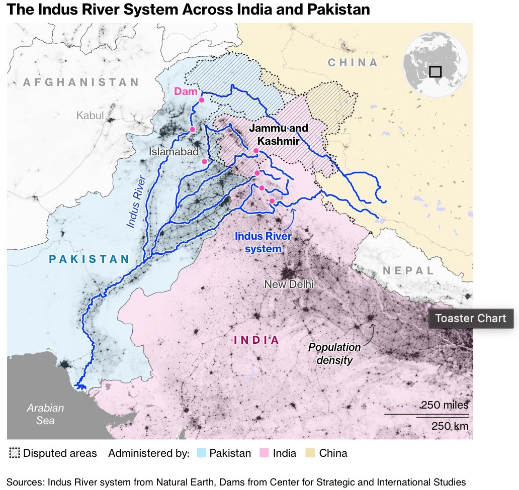
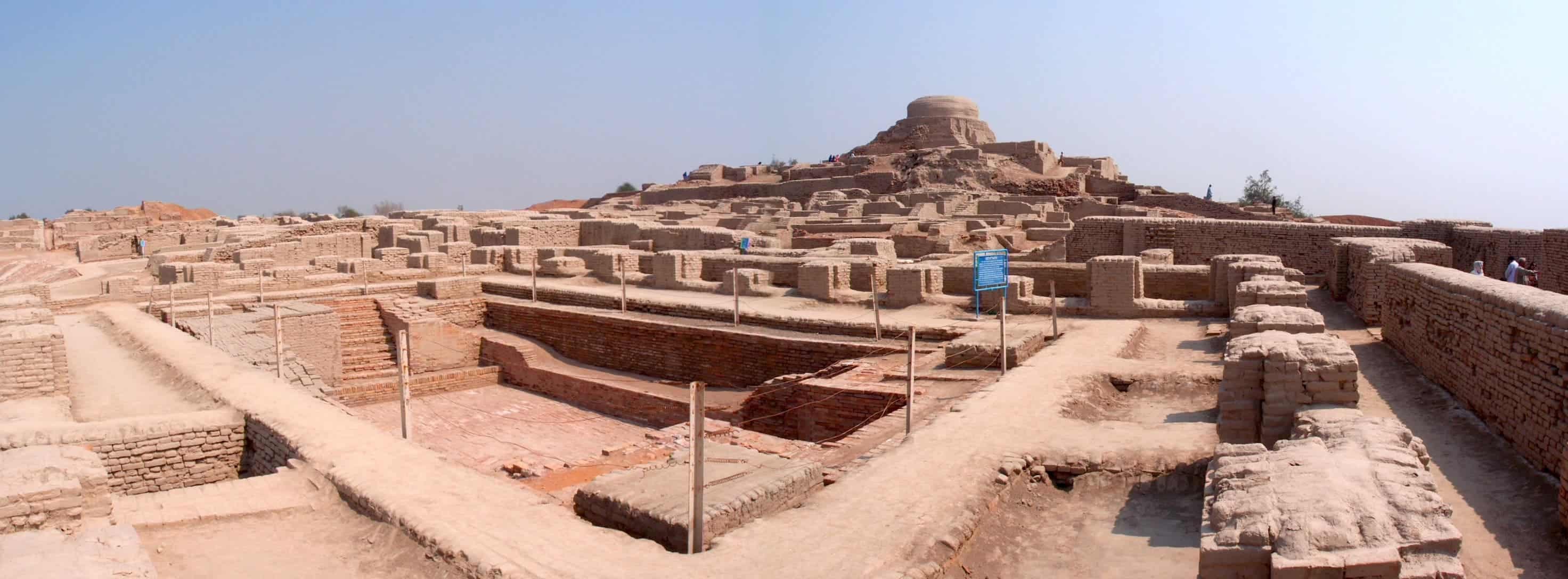
Mapping the Cradle of Civilization - How Geography Shaped the Indus Valley
--
https://americangeo.substack.com/i/166074972/mapping-the-cradle-of-civilization-how-geography-shaped-the-indus-valley <-- shared technical article
--
https://www.bbc.co.uk/programmes/p0f508nx <-- shared BBC podcast
--
#GIS #spatial #mapping #IndusWatersTreaty #IndusValleyCivilization #Harappan #agriculture #urban #cities #trade #transportation #technology #geography #BronzeAge #civilisations #hydrology #water #surfacewater #waterresources #snowmelt #watersecurity #history #ancienthistory #Indus #IndusRiver
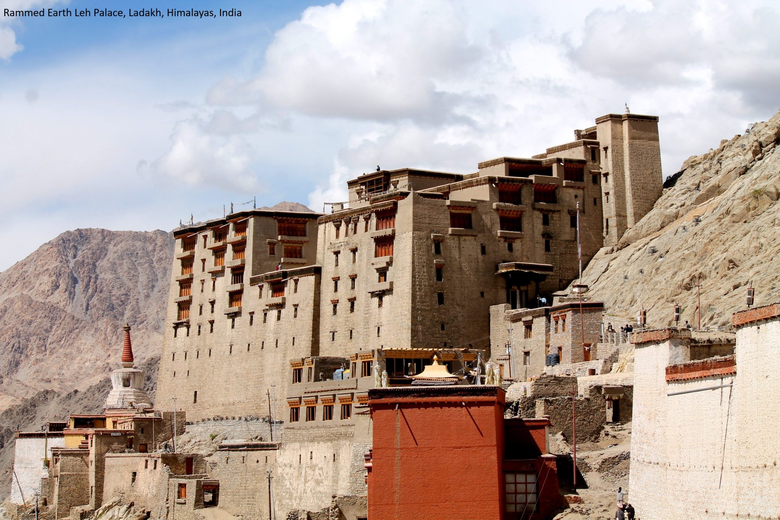
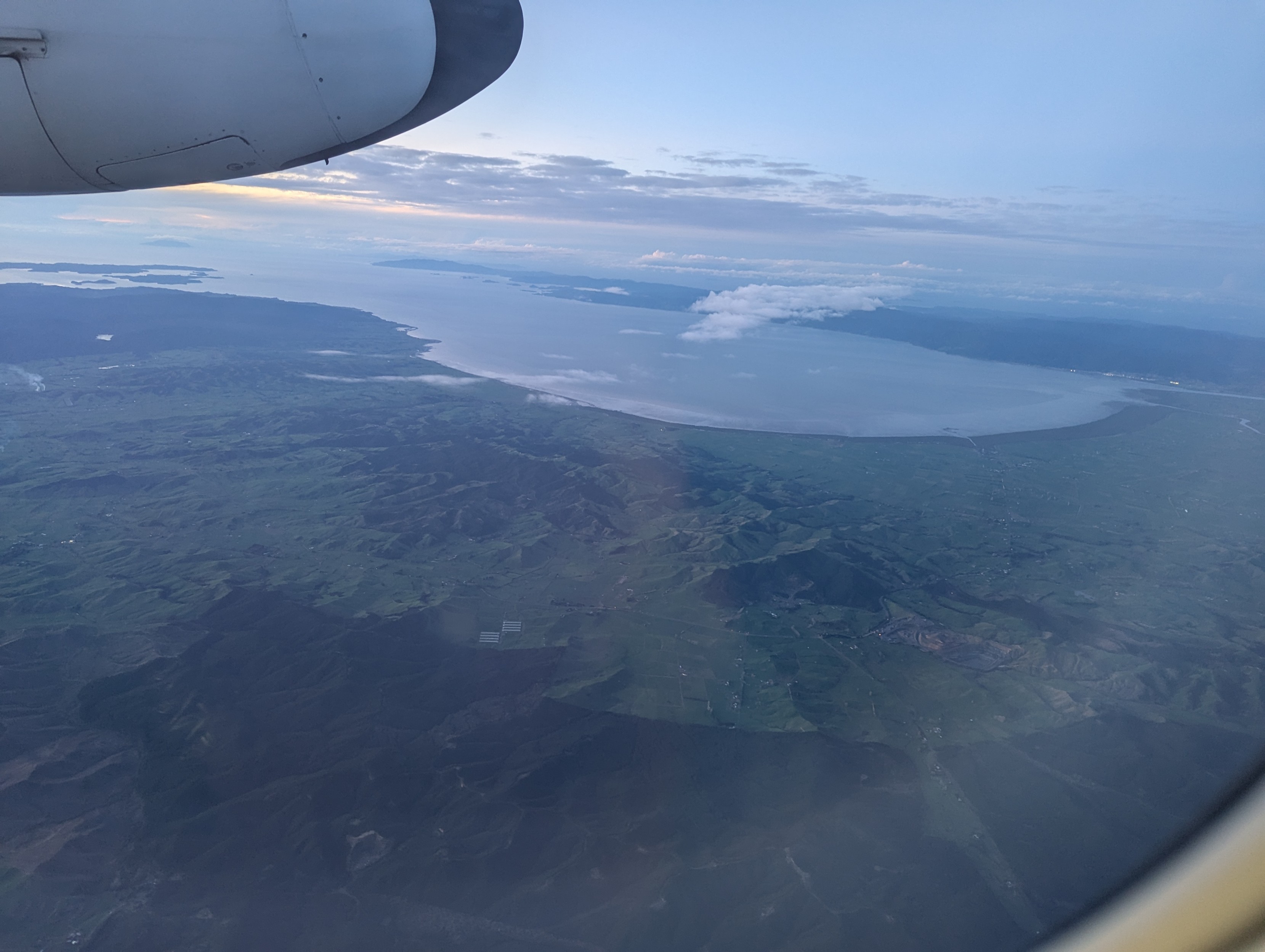
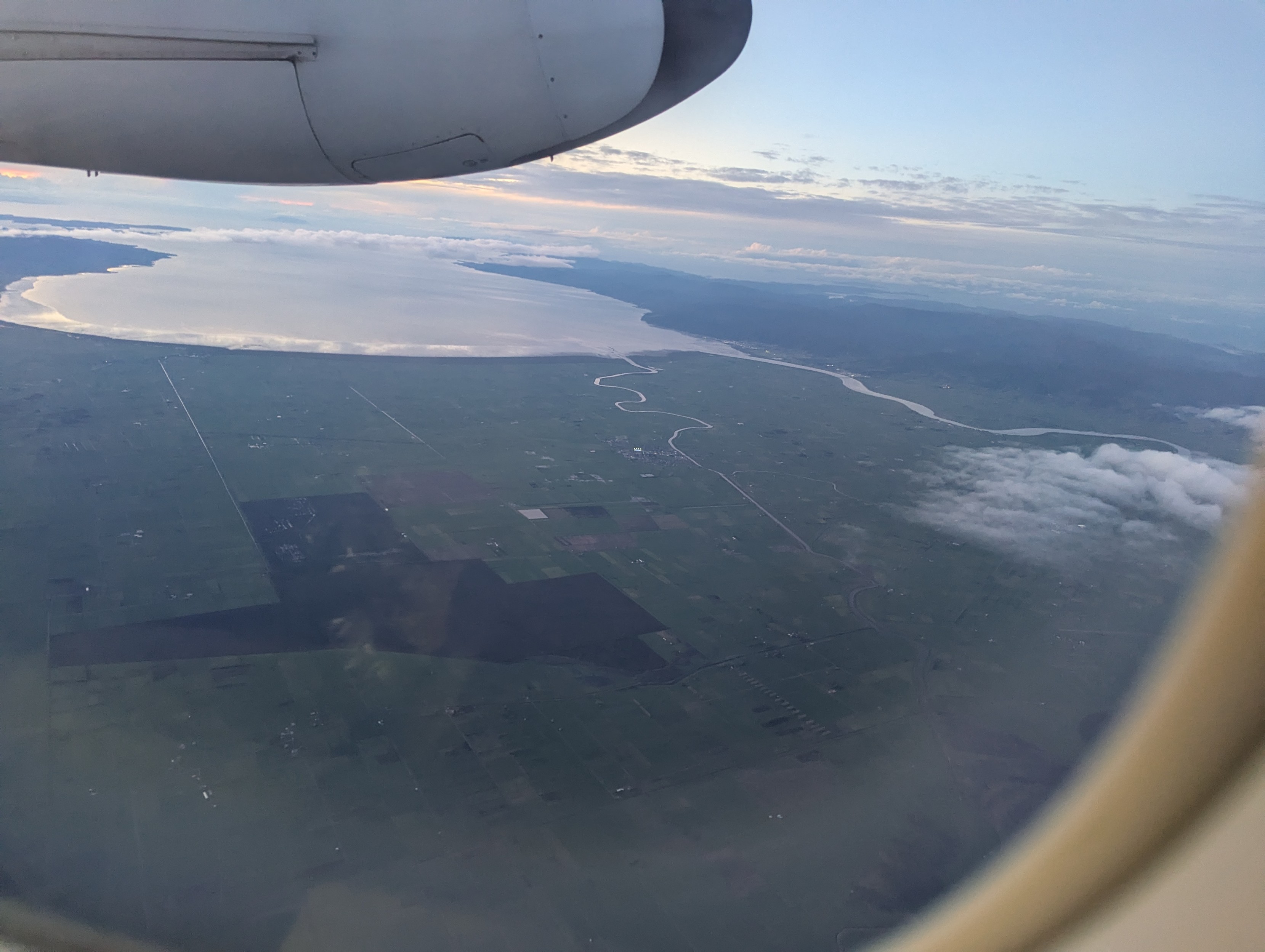
#WhereAmI ????
Clues:
• Southern Hemisphere
• the size of the aeroplane
• the geomorphology / coastline / agriculture / hydrography
#GIS #spatial #mapping #whereami #geography #geomorphology #hydrology
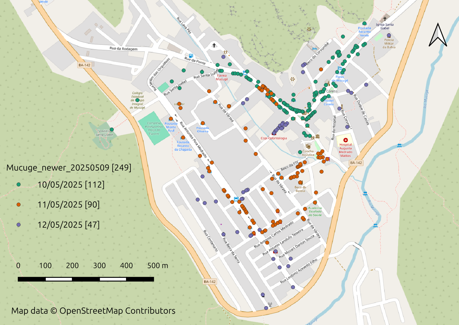
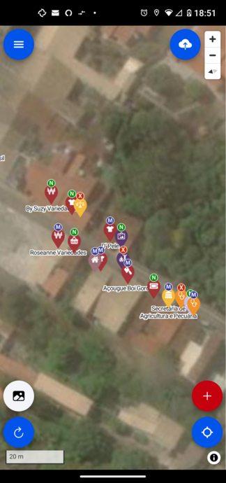
Petit récit de #mapping terrain des POI #openstreetmap #osm à mes heures perdues avec #Osm_Go! lors d’un court séjour à Mucugê, dans la Chapada Diamantina de Bahia au #bresil J’encourage d’autres cartographes OSM de terrain à partager leur propre expérience avec le mot-clé #MakeYourStayOSM!
@RegisHaubourg
@arnold_nkwabong
@Engelbertmodo
@grischard
@saliousoft
@pierzen
@vinber
?
PyQGIS-Video: Massenberechnung mit QGIS / Mass calculation with QGIS https://geoobserver.de/2025/06/19/pyqgis-video-massenberechnung-mit-qgis/ #qgis #switch2qgis #gistribe #gischat #fossgis #foss4g #OSGeo #spatial #geospatial #opensource #mapping #DataViz #gis #geo #geoObserver pls RT via @PyQgis

Kigali’s junction upgrades are critical, but without improvements in public transport, rising vehicle traffic will erase their benefits.
attn xitter @smartcityhubrw
via bsky @itsinternational.bsky.social
"Rwanda's mobility plan in seven junctions"
https://www.itsinternational.com/feature/rwandas-mobility-plan-seven-junctions
#Rwanda #Kigali #SmartCityHubRw #cityplanning #urbandesign #urbanplanning #inclusiveplanning #SDG11 #mapping #publictransit #publictransport #TrufiAssociation
WWF: The most comprehensive mapping to date of the world’s wetlands. “Now a new study aims to deliver the most accurate mapping of global wetland types to date. The revised Global Lakes and Wetlands Database provides information on the locations and extent of 33 separate wetland types.”
https://rbfirehose.com/2025/06/17/wwf-the-most-comprehensive-mapping-to-date-of-the-worlds-wetlands/
#ArcGISPro at the 2025 #Esri User Conference https://tinyurl.com/3cdnedcb
#EsriUC2025 #UC2025 #GIS #arcgis #GISChat #geospatial #mapping #spatialAnalysis @esri @esriuc @esrifederalgovt @esrislgov @arcgispro @esritraining @urisa

Our project in Toluca and Oaxaca—with Codeando México, and HOT. Community-led mapping can transform informal networks into structured, data-informed systems.
via GIZ Mexico
xitter @mapeadora @SmartCityLATAM @hotosm @CodeandoMexico
#Mexico #Oaxaca #Toluca #SalinaCruz #informaltransport #populartransport #mapping #GIS #GeospatialData #OpenStreetMap #HOTOSM #publictransit #publictransport #TransportationJustice #TrufiAssociation
City University of New York: Hunter Researchers Help Struggling Areas With Heat-Mapping Tool. “The NYC Urban Heat Portal, launched on April 15, shows how rising temperatures affect different New York City’s neighborhoods, providing a guide to the most vulnerable communities. The poorest communities in the city are also the hottest ones, because they lack shade trees and other greenery and […]
New mapping to increase Quebec homes in flood zones by about 30%
Quebec's environment minister says about 30 per cent more homes could be located in flood zones when new maps come into effect next year.
#flood #housing #mapping #Quebec #News #Canada
https://www.cbc.ca/news/canada/montreal/quebec-flood-maps-1.7560044?cmp=rss
Client Info
Server: https://mastodon.social
Version: 2025.04
Repository: https://github.com/cyevgeniy/lmst