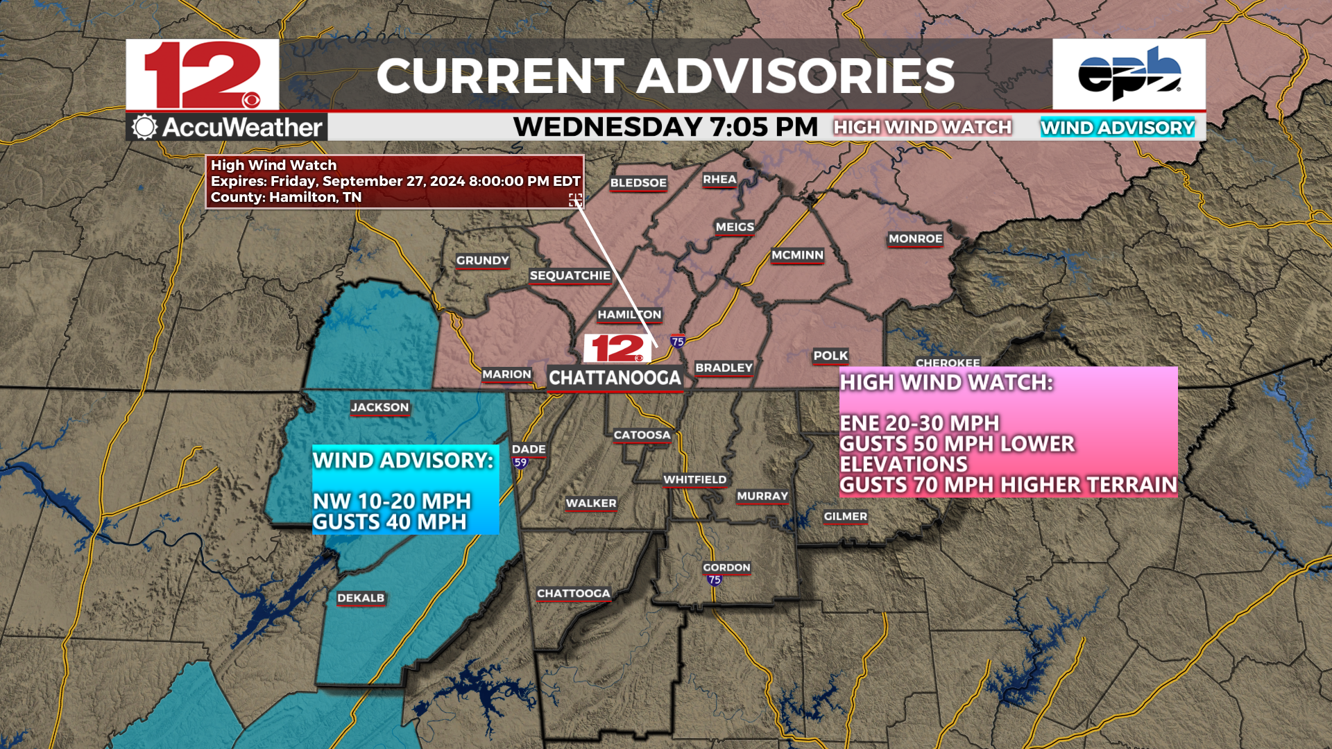
#HighWindWatch

2025-02-11

HIGH WIND WATCH,
FROM WEDNESDAY EVE (2/12) THRU FRIDAY MORN

Southwest winds 25 to 35 mph with gusts up to 60 mph possible.

WHERE: East #SFBay & #SanFrancisco Bay Shoreline, Interior Central Coast, North SF Bay Interior Mountains & Valleys, #SantaClara Valley & Eastern Hills & #SantaCruz Mountains. #California

IMPACTS: Damaging winds could blow down trees and power lines. Widespread power outages are possible. Travel could be difficult,
especially for high profile vehicles. Strong winds may move loose debris, result in minor damage property, and cause sporadic power outages. Travel could become difficult, especially for high profile vehicles. The combination of wind and moist soils will increase the risk for downed trees.

PRECAUTIONARY/PREPAREDNESS ACTIONS: Monitor the latest forecasts and warnings for updates.

Secure loose outdoor objects that could be blown around or damaged
by the wind.

#Wind #HighWindWatch #CAwx #CaliforniaWeather #NorCalWx

forecast.weather.gov/showsigwx

2025-01-09

#RedFlagWarning
#WindAdvisory
#HighWindWatch

To read details from NOAA, open the map, click colored area, follow the link. Scroll down in the popup since each type of watch or warning has its own link for the details.

Latest perimeter for the #PalisadesFire shows 17,234 acres burned. Zoom in for details.

The maps has lots of #GIS layers that you can turn on/off/restack.
You can make your own custom map links that show the data you want to see.
You can change the ‘top’ layer that is clickable to see attribute data.
Need help? Open the map and see 2 links upper left corner.
#EatonFire #SunsetFire #Geospatial #GISchat

Open GISsurfer map:
mappingsupport.com/p2/gissurfe

2025-01-04

#HighWindWatch

To read details from NOAA, open the map, click colored area, follow the link. Scroll down in the popup since the spot you clicked might have more than one type of weather watch/warning and each one has its own link for the details.
#CAwx

Open GISsurfer map:
mappingsupport.com/p2/gissurfe

Meteorologist Austen OnekWDEFAustenOnek
2024-09-25

- In the @wdefnews12 viewing area, NE Alabama under a , SE Tennessee & western North Carolina under a for gusty winds courtesy of approaching .

Winds could make travel difficult for the area Thu PM into Fri AM.

#HighWindWatch for SE Monroe County #TNwx in the @wdefnews12
viewing area. South winds 25-40 mph with gusts up to 65 mph possible at times, becoming west. Locally higher gusts possible Saturday night in the mountains and foothills of east Tennessee.

#WDEFWeather: Tennessee River Valley area bracketed by #WindAdvisory to the west and #HighWindWatch to the east as our next storm systems approach. Details tonight on #WDEFNews12.

Client Info

Server: https://mastodon.social
Version: 2025.04
Repository: https://github.com/cyevgeniy/lmst