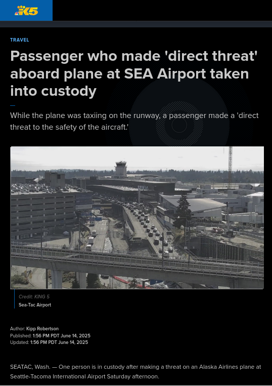
"Passenger who made 'direct threat' aboard plane at SEA Airport taken into custody" by KING5 News (NBC Seattle) - Closure of two runways at Seattle-Tacoma Int'l Airport #KSEA was due to an Alaska Airlines flight operated by subsidiary Horizon Air, with a passenger making a security threat leading to law enforcement response on the airport ramp. So the runway closures were coincidental to the protests at the airport, not because of them. https://www.king5.com/article/travel/departures-grounded-sea-airport-security-incident-runway/281-1a932ea6-9772-4e83-a326-77f54480d97c #aviation #travel #avgeek #PNW
#KSEA
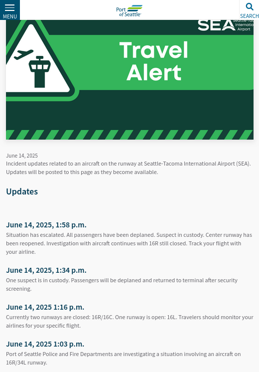
Thanks to @W1PAC for the link. At least contributing to the diversions of Seattle-bound flights was an incident with an unruly passenger that closed #SEA / #KSEA runways 16R and 16C. But the web site's timeline starts 20 minutes after Seattle-bound planes were diverting to Portland. https://www.portseattle.org/news/june-14-aircraft-incident #aviation #travel #avgeek #PNW
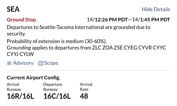
Seattle Airport #KSEA is ground-stopped by FAA due to a security issue, presumably related to protests already known to be occurring at the airport. Multiple diversions into Portland #KPDX. #aviation #travel #avgeek #PNW
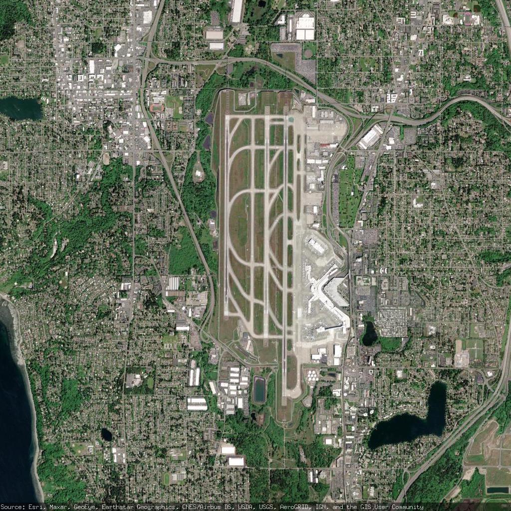
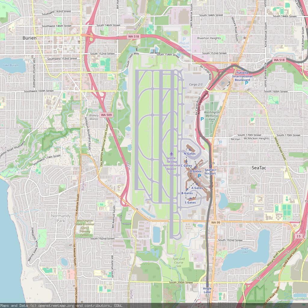
Seattle–Tacoma International Airport - Seattle, United States
https://en.wikipedia.org/wiki/Seattle%E2%80%93Tacoma_International_Airport
https://www.openstreetmap.org/#map=13/47.447943/-122.310276
#KSEA #SEA #Seattle #UnitedStates #airport #aviation #avgeeks #GIS
huh...
As of 8:38 am PDT May 19 it looks like it's snowing pretty good up at Stevens Pass US 2 in Washington state
Stevens is at 4,061 feet so I'm not surprised, and there's bands of rain down in the Puget Sound lowlands
Weether reports have stopped for the year so it's just eyeball reporting
Looks a little plowed, maybe
Here: https://wsdot.com/travel/real-time/mountainpasses/stevens
Aviation weather for Seattle Tacoma International airport (USA) is “KSEA 071953Z 23010KT 10SM SCT020 BKN041 BKN060 17/10 A3000 RMK AO2 SLP164 T01670100” : See what it means on https://www.bigorre.org/aero/meteo/ksea/en #seattle #usa #seattletacomainternationalairport #ksea #sea #metar #aviation #aviationweather #avgeek vl
This is the Forecast Discussion from KSEA / Seattle WA NWS at Sunday 04/06/2025 09:11:38 PDT
SYNOPSIS:
Front moving through Western Washington tonight with rain out ahead of the system spreading over the area today
Upper level trough behind the front Monday with the trough axis moving through Tuesday
Upper level ridge trying to build Wednesday
Next system arriving late Thursday with another upper level trough behind it for Friday
Copy-pasted from the "Deep Weather" app on my iPhone 14
This is the Forecast Discussion from KSEA / Seattle WA NWS at Tuesday 03/25/2025 14:54:53 PDT
SYNOPSIS:
The focus shifts to convection on Wednesday, with impactful weather on tap for all of western Washington
As a low pressure system approaches the Pacific Coast, showers and embedded thunderstorms are likely to form over the Olympic Peninsula throughout the mid to late morning hours
A dynamic warm front will lift across the region throughout the afternoon and into the evening, bringing a round of widespread and potentially strong thunderstorms northward
The primary threats for these storms will be hail and/or gusty winds, alongside frequent lightning and locally heavy rain
The strongest storms are currently favored to move northward east of the Puget Sound Wednesday along the I-5 corridor during the mid- to-late afternoon, likely causing impacts for the afternoon commute
Copy-pasted from the "Deep Weather" app on my iPhone 14
Stevens Pass WA, US 2
US 2 at MP 64.6: East Stevens Pass
Pass report:
Elevation 4061 ft / 1238 m
Temperature 43°F / 6°C as of 3:04 AM 03/24/2025
Snoqualmie Pass WA, I-90
I-90 at MP 52: Snoqualmie Summit
Pass report:
Elevation 3022 ft / 921 m
Temperature 42°F / 6°C as of 2:11 AM 03/24/2025
This is the Forecast Discussion from KSEA / Seattle WA NWS at Sunday 03/23/2025 09:51:55 PDT
SYNOPSIS:
An atmospheric river will continue to bring heavier precipitation through tonight, especially for the Olympics and Cascades from King County northwards
Snow levels also continue to rise this morning, however, moderate to heavy snow will continue for another couple hours at Stevens Pass before transitioning to rain
Otherwise, our friends at the Northwest Avalanche Center have an Avalanche Warning up for the Cascades
In addition, breezy winds are expected today, with gusts generally ranging 20 to 40 MPH, and near 45 MPH around Everett and Admiralty Inlet
No major forecast updates this morning
Copy-pasted from the "Deep Weather" app on my iPhone 14
This is the Forecast Discussion from KSEA / Seattle WA NWS at Tuesday 03/18/2025 09:17:39 PDT
SYNOPSIS:
Temporary weak upper level ridge building over Western Washington today. The ridge will shift east tonight with the next front approaching the area Wednesday
Front moving through Wednesday night into early Thursday morning with rain and locally windy conditions
Another system riding a somewhat strong jet stream will reach the area Thursday night into Friday followed by a system Saturday
Possible atmospheric river setting up Sunday before lifting north Monday.
Copy-pasted from the "Deep Weather" app on my iPhone 14
This is the Forecast Discussion from KSEA / Seattle WA NWS at Wednesday 03/12/2025 08:07:23 PDT
SYNOPSIS:
Satellite and radar imagery show scattered showers across western Washington this morning, with the cold front situated offshore and the low pressure center just off central Vancouver Island
This low will continue to work its way northeast into British Columbia, as such, it will slowly drag the cold front onshore
Rain will continue into tonight, devolving into scattered showers late tonight into Thursday morning. Showers will continue throughout the day on Thursday
Copy-pasted from the "Deep Weather" app on my iPhone 14
This is the Forecast Discussion from KSEA / Seattle WA NWS at Saturday 03/08/2025 08:33:08 PST
SYNOPSIS:
Satellite imagery shows atmospheric river extending from Vancouver Island southwest back to near 35N/140W
Doppler radar shows rain from about Hoquiam to Everett northward. Cloudy skies over the remainder of the area
Temperatures at 3 am/11z were in the 40s
Weak atmospheric river wobbling around over the coast and northern portions of the area this morning into the afternoon hours
Upper level trough back between 135-140W digging south this afternoon will change the orientation of the river from southwest to northeast to a little more north/south
This will push the river a little north lowering the rain chances across all but the north coast and near the Canadian border later this afternoon
Copy-pasted from the "Deep Weather" app on my iPhone 14
This is the Forecast Discussion from KSEA / Seattle WA NWS at Thursday 03/06/2025 04:35:59 PST
SYNOPSIS:
Dry, northerly, flow sets up over WA today with high pressure centered offshore (near 130W). Clearing skies have allowed temps to dip into the 30s and lower 40s early this morning with freezing temps around the south sound. Near the surface, there's patchy low clouds and fog in the interior that will burn off through the late morning. Expect plenty of sun this afternoon with highs in the low to mid 50s.
The ridge shifts inland Friday and Saturday for more dry and mild weather. The air mass will be a little warmer with highs on Saturday reaching the upper 50s to lower 60s. Morning lows will still be chilly and in the 30s
Copy-pasted from the "Deep Weather" app on my iPhone 14
This is the Forecast Discussion from KSEA / Seattle WA NWS at Monday 03/03/2025 05:55:18 PST
SYNOPSIS:
A broad upper level trough over the southwest will continue to move eastward this morning, being replaced by a brief transitory ridge nudging in tonight into Tuesday. Latest radar imagery shows a few light scattered showers over the Puget Sound interior
Light scattered showers will continue throughout the day on Monday, with the best chances over the Cascades. Weak convergence today into this evening may locally enhance precipitation amounts over the central Cascades
The ridge will build tonight into early Tuesday, allowing for a brief dry period Tuesday morning. The next upper level trough and associated surface frontal system will arrive Tuesday afternoon into Tuesday evening, with showers continuing into Wednesday
Copy-pasted from the "Deep Weather" app on my iPhone 14
This is the Forecast Discussion from KSEA / Seattle WA NWS at Saturday 03/01/2025 06:46:19 PST
SYNOPSIS:
Satellite imagery shows stratus over the offshore waters as well as areas of fog developing in the river valleys. This fog will once again be quite shallow and should burn away quickly this morning.
High temperatures will be notably cooler on the coast where mostly cloudy conditions prevail all day--in the low to mid 50s. Elsewhere, conditions will be fairly similar to yesterday, with highs in the upper 50s to low 60s. Mid to upper 60s may be possible in the Cascade valleys
Rain showers will arrive along the coast this afternoon, slowly spreading inland overnight and continuing into Sunday and early Monday. Total rainfall amounts will be on on the order of one to two tenths of an inch through most of the lowlands, with up to half an inch possible in the mountains and along the Pacific coast
Copy-pasted from the "Deep Weather" app on my iPhone 14
This is the Forecast Discussion from KSEA / Seattle WA NWS at Friday 02/28/2025 05:35:06 PST
SYNOPSIS:
Satellite imagery shows stratus along the coast slowly creeping inland through the valleys of southwestern Washington as well as down the Strait of Juan de Fuca.
Surface observations and traffic cameras are showing this to be mostly stratus,though there is sufficient low level moisture such that some patchy fog mixed in there at times.
Fog may be locally dense in some spots.
Come sunrise this morning, expect most of the western Washington lowlands to be under stratus and patchy fog. This will help moderate low temperatures this morning, bottoming out in the upper 30s to low 40s.
Today's high temperatures reaching the mid 50s to low 60s. Overnight lows again in the upper 30s to low 40s.
Copy-pasted from the "Deep Weather" app on my iPhone 14
This is the Forecast Discussion from KSEA / Seattle WA NWS at Wednesday 02/26/2025 05:57:09 PST
SYNOPSIS:
Drier and warmer conditions are expected today with upper level ridging over the region.
A weak front will approach the region on Thursday and weaken over the area, bringing some light showers to western Washington.
Conditions then look to dry out again on Friday before chances of precipitation return for the weekend and persist into early next week.
Copy-pasted from the "Deep Weather" app on my iPhone 14
This Message is from Washington State Ferries @ Monday 02/24/2025 12:40:26 PST
All ferry passengers should be prepared for possible service disruptions starting this afternoon through tomorrow morning due to high winds
Anacortes/San Juan Islands and Port Townsend/Coupeville routes:
With stronger winds in the north, we expect these routes to be most impacted by severe weather. This could include delays and cancellations.
All routes:
Passengers can expect a bumpy ride due to choppy waters. To better stabilize vessels, we may load them to full vehicle capacity and operate at slower speeds.
We will continue to closely monitor the situation and send rider alerts as changes occur. We want to thank you in advance for your patience and understanding as delays and cancellations are likely.
#WAwx #ORwx #BCwx #PNWwx #PNW #KSEA #NWS #WX #Weather #HighWinds #WSF
Flood Watch
National Weather Service Seattle WA
410 AM PST Sat Feb 22 2025
Counties: Grays Harbor-King-Lewis-Pierce-Skagit-Snohomish-Thurston
Including the cities of: Aberdeen, Tacoma, Everett, Olympia, Sedro-Woolley, Lynnwood, Edmonds, Anacortes, Seattle, Chehalis
...FLOOD WATCH REMAINS IN EFFECT FROM SUNDAY MORNING THROUGH LATE TUESDAY NIGHT...
* WHAT...Flooding caused by excessive rainfall continues to be possible
* WHERE...Portions of northwest and west central Washington, including the following counties, in northwest Washington, Grays Harbor and Skagit
In west central Washington, King, Lewis, Pierce, Snohomish and Thurston
* WHEN...From Sunday morning through late Tuesday night
* IMPACTS...Excessive runoff may result in flooding of rivers, creeks, streams, and other low-lying and flood-prone locations
Flooding may occur in poor drainage and urban areas. Landslide risk will also increase through this period
#WAwx #ORwx #BCwx #PNWwx #PNW #KSEA #NWS #WX #Weather #Flooding
Client Info
Server: https://mastodon.social
Version: 2025.04
Repository: https://github.com/cyevgeniy/lmst