#NAVSTAR

Kevin Karhan :verified:kkarhan@infosec.space
2025-07-05

@SamantazFox OFC there is.

#NOTAMs are already being issued and the airspace over the Oblast Kaliningrad is closed as in the "P.R." China or North Korea: "Intruders may be shot down without warning"...

  • Not shure if this only impacts #NAVSTAR-#GPS and #SBAS like #Galileo (which I don't count as #GNSS due to being technologically inferior to GPS to enforce #US hegemonial interests), or if #GLONASS and #BeiDou / #COMPASS are also affected. I certainly have neither time nor desire to "fuck around and find out"
Kevin Karhan :verified:kkarhan@infosec.space
2025-05-04

@ukraine OFC if a #drone is #preprogrammed then it's not susceptible to #jamming.

AwattoAnalogAwattoAnalog
2025-02-25

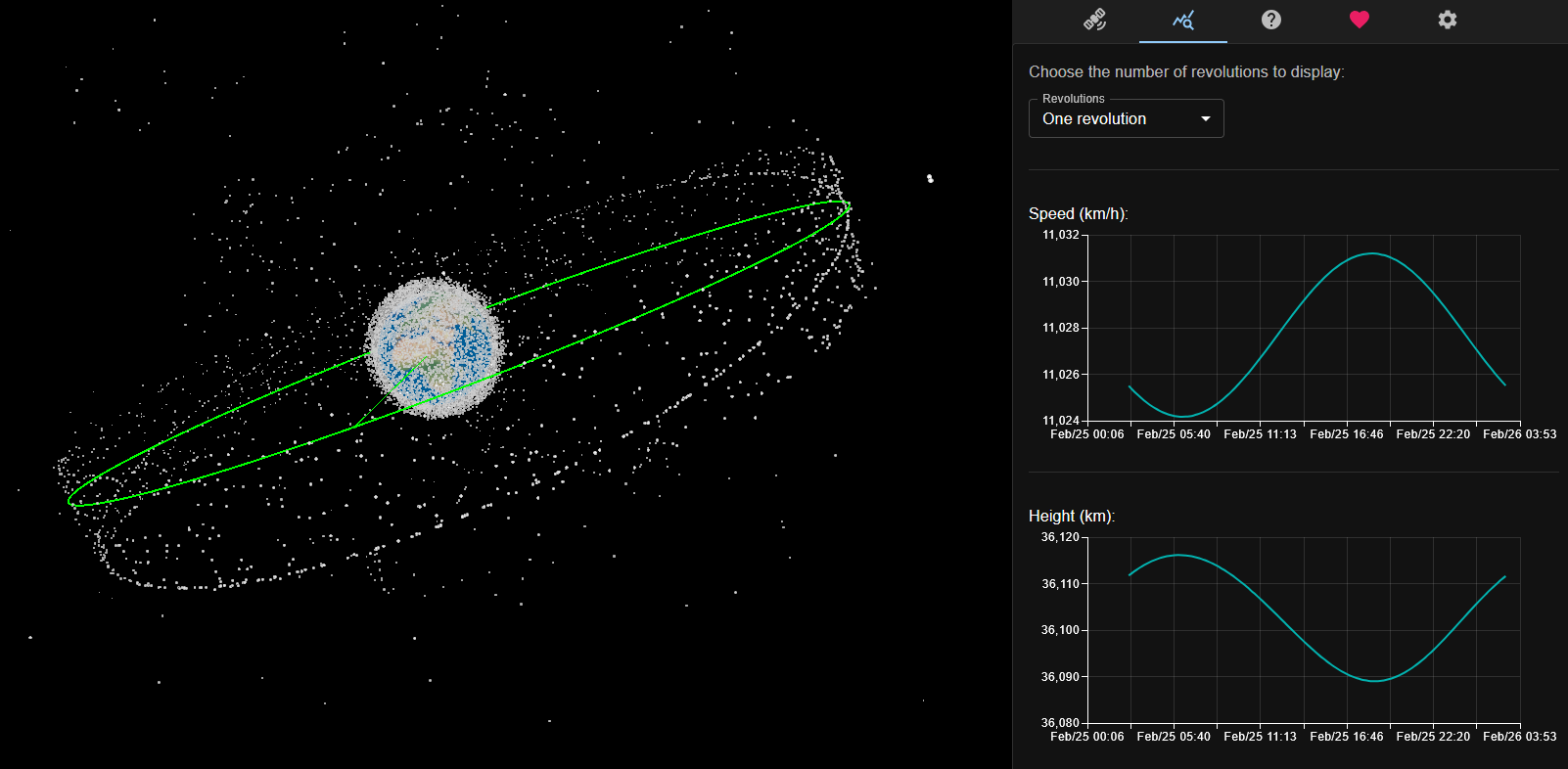
Space has become very, very cluttered.

Satellite Tracker 3D is a premier platform for real-time, 3D tracking of over 24,000 satellites directly in your browser.

Starlink satellites are noticeably closer to Earth.

Source: satellitetracker3d.com/

Kevin Karhan :verified:kkarhan@infosec.space
2024-04-30

@evawolfangel ich kann nur die üblichen Dinge an Informationen rezitieren.

  • Es gibt zzt. nur 3 GNSS: #NAVSTAR-#GPS, #GLONASS & #COMPASS!
  • #Galileo ist nur ein #SBAS, da technologisch suzerän zu GPS, weil die #EU sich #US-Hegemonialinteressen unterordnete statt auf dem aktuellen Stand der Technik etwas selbst zu enteickeln.
  • #NavIC als GNSS von Indien ist noch im Aufbau.
  • #Jammer senden entweder falsche Daten oder sehr starkes rauschen.
  • Da alle #GNSS auf demselben Prinzip arbeiten: Atomuhren auf Satelliten auf Basis deren Position und Signallaufzeit die exakte Uhrzeit und Position errechnet wird, ergeben minimale Abweichungen exponentiell größere Ungenauigkeiten.
  • Es bedarf immer mindestens 4 Satelliten pro GNSS um die Position zu bestimmen.
  • GPS wird auch als hochpräzise Zeitquelle genutzt um z.B. bei Richtfunkstrecken sowohl Frequenzen zu synchronisieren als auch präzises Beamforming basierend auf gegenseitigen Installationsort auszuüben. Mangelndes GPS-Sigbal führt zu Durchsatzreduktion.
  • Jamming und Signaldegradation wird nicht nur von #Russland als Waffe genutzt sondern ist bei GPS sogar ein Feature: Nennt sich "#SelectiveAvailability" und betrifft das zivil frei empfangbare C/A - Signal.
  • Die militärischen P/Y & W-Signale sind weitaus störresistenter moduliert. GLONASS z.B. nutzt stattdessem sogar zwei Trägerfrequenzen um Jammer zu erkennen...
  • Am meisten stört es die zivile Luftfahrt da dort quasi aisschließlich NAVSTAR-GPS genutzt word um die Position zu bestimmen, wobei kleinste Ungenauigkeiten Fehler in der Größenordnung mehrerer Kilometer erzeugen, was bei modernen Jets die quasi ausschließlich auf Instrumentenflug geflogen werden ein massives Problem ist: Auf Reiseflughöhe von ~ 10km und bei schlechtem Wetter ist eine Navigation auf Sicht quasi unmöglich...
Kevin Karhan :verified:kkarhan@infosec.space
2024-04-29

@LukaszOlejnik I guess the fact that most systems only use #NAVSTAR-#GPS and not #COMPASS & #GLONASS as well complicate things.

Sadly to appeasr #US #hegemony interests, the #EU downgraded #Galileo into a #SBAS instead of a real, independent #GNSS, making it easier to jam than GPS!

Kevin Karhan :verified:kkarhan@mstdn.social
2023-08-08

@NK30 I do track that.

AFAIK #COMPASS should work.

Not shure if #GLONASS and #COMPASS are having "Selected Availability" aka. purposeful signal degradation enabled or can do it.

#Galileo is just an #AGPS system due to being purposefully #downgraded during design to be less secure and reliable than #NAVSTAR - #GPS, which can explain worse reception!

en.wikipedia.org/wiki/Galileo_

Kevin Karhan :verified:kkarhan@mstdn.social
2023-01-14

@AufDistanz Würde mal fragen, warum man sich beim #GNSS #Galileo für technologische #Suzeränität im Vergleich zu #NAVSTAR / #GPS, #GLONASS & #COMPASS / #Beidou entschieden hat...

Client Info

Server: https://mastodon.social
Version: 2025.07
Repository: https://github.com/cyevgeniy/lmst