#PotentialTropicalStorm

2025-09-27

#Imelda #PotentialTropicalStorm #Atlantic

BULLETIN
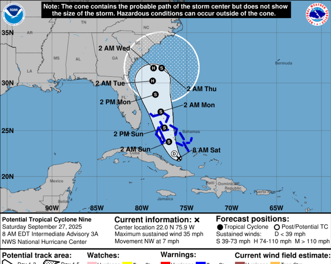
Potential Tropical Cyclone Nine Intermediate Advisory # 3A
NWS NHC Miami FL
800 AM EDT Sat Sep 27 2025

...DISTURBANCE GRADUALLY BECOMING BETTER ORGANIZED...
...EXPECTED TO BECOME A TROPICAL STORM AND PRODUCE SIGNIFICANT
RAINFALL OVER PORTIONS OF EASTERN CUBA AND THE BAHAMAS...

SUMMARY OF 800 AM EDT NFO:

LOCATION...22.0N 75.9W
ABOUT 170 MI...275 KM NW OF THE EASTERN TIP OF CUBA
ABOUT 110 MI...180 KM S OF THE CENTRAL BAHAMAS
MAXIMUM SUSTAINED WINDS...35 MPH...55 KM/H
PRESENT MOVEMENT...NW OR 315 DEGREES AT 7 MPH...11 KM/H
MINIMUM CENTRAL PRESSURE...1005 MB...29.68 INCHES

WATCHES AND WARNINGS IN EFFECT:

A Tropical Storm Warning is in effect for...
* Central Bahamas, including Cat Island, the Exumas, Long Island, Rum Cay, and San Salvador
* Portions of the northwestern Bahamas, including Eleuthera, New Providence, the Abacos, Berry Islands, Andros island, and Grand Bahama Island

DISCUSSION AND OUTLOOK: At 800 AM EDT (1200 UTC), the disturbance was centered near latitude 22.0 North, longitude 75.9 West. The system is moving toward the northwest near 7 mph (11 km/h). A north-northwestward motion is
expected to begin later today and continue through Monday. On the forecast track, the center of the system is expected to move across the central and northwestern Bahamas this weekend and approach the southeast U.S. coast early next week…

NEXT ADVISORY: Next complete advisory at 1100 AM EDT.

$$
Forecaster Reinhart

Cone of uncertainty for Potential Tropical Cyclone Imelda
2025-09-27

#Imelda #PotentialTropicalStorm #Atlantic

BULLETIN
Potential Tropical Cyclone Nine Advisory # 3
NWS NHC Miami FL
500 AM EDT Sat Sep 27 2025

...DISTURBANCE HAS BECOME A LITTLE BETTER ORGANIZED...
...EXPECTED TO BECOME A TROPICAL STORM AND PRODUCE SIGNIFICANT RAINFALL OVER PORTIONS OF EASTERN CUBA AND THE BAHAMAS...

SUMMARY OF 500 AM EDT INFO:

LOCATION...21.9N 75.8W
ABOUT 155 MI...250 KM NW OF E TIP OF CUBA
ABOUT 115 MI...190 KM S OF THE CENTRAL BAHAMAS
MAXIMUM SUSTAINED WINDS...35 MPH...55 KM/H
PRESENT MOVEMENT...NW OR 315 DEGREES AT 7 MPH...11 KM/H
MINIMUM CENTRAL PRESSURE...1007 MB...29.74 INCHES

WATCHES AND WARNINGS: The Meteorological Service of the Bahamas has issued a Tropical Storm Warning for portions of the northwestern Bahamas, including Eleuthera, New Providence, the Abacos, Berry Islands, Andros Island, and Grand Bahama Island.

DISCUSSION: At 500 AM EDT (0900 UTC), the disturbance was centered near latitude 21.9 North, longitude 75.8 West. The system is moving toward the NW near 7 mph (11 km/h). A N-NW motion is
expected to begin later today and continue through Monday. On the forecast track, the center of the system is expected to move across the central and northwestern Bahamas this weekend and approach the SE U.S. coast early next week…

NEXT ADVISORY

Next intermediate advisory at 800 AM EDT.
Next complete advisory at 1100 AM EDT.

$$
Forecaster Beven

Graphic showing cone of uncertainty for 94L Potential Tropical Storm Imelda
2025-09-26

#Imelda #PotentialTropicalStorm #Atlantic

BULLETIN
Potential Tropical Cyclone 9 Advisory # 1
NWS NHC Miami FL
500 PM EDT Fri Sep 26 2025

...TROPICAL STORM WATCHES AND WARNINGS ISSUED FOR PORTIONS OF THE BAHAMAS...

SUMMARY OF 500 PM EDT

LOCATION...20.9N 74.6W
ABOUT 55 MI...90 KM NNW OF THE EASTERN TIP OF CUBA
ABOUT 200 MI...325 KM SSE OF THE CENTRAL BAHAMAS
MAXIMUM SUSTAINED WINDS...35 MPH...55 KM/H
PRESENT MOVEMENT...NW OR 305 DEGREES AT 9 MPH...15 KM/H
MINIMUM CENTRAL PRESSURE...1008 MB...29.77 INCHES

WATCHES AND WARNINGS

The government of the Bahamas has issued a TS Warning for the central Bahamas and a TS Watch for portions of the NW Bahamas.

HAZARDS AFFECTING LAND

…WIND: Tropical storm conditions are expected in the tropical storm warning area beginning SAT night & are possible in the watch area on SUN.

…STORM SURGE: A storm surge will raise water levels by as much as 1 to 3 feet above ground level along the immediate coast in areas of onshore winds in the northwestern Bahamas. Near the coast, the surge will be accompanied by large waves.

SURF: Swells generated by both this system and Hurricane Humberto will affect portions of the Bahamas this weekend, and spread to portions of the southeast U.S. coast early next week. These swells are likely to cause life-threatening surf and rip current conditions…

NEXT ADVISORY
Next intermediate advisory at 800 PM EDT.
Next complete advisory at 1100 PM EDT.

$$
Forecaster Cangialosi

Potential track of Imelda into the Carolinas

Client Info

Server: https://mastodon.social
Version: 2025.07
Repository: https://github.com/cyevgeniy/lmst