
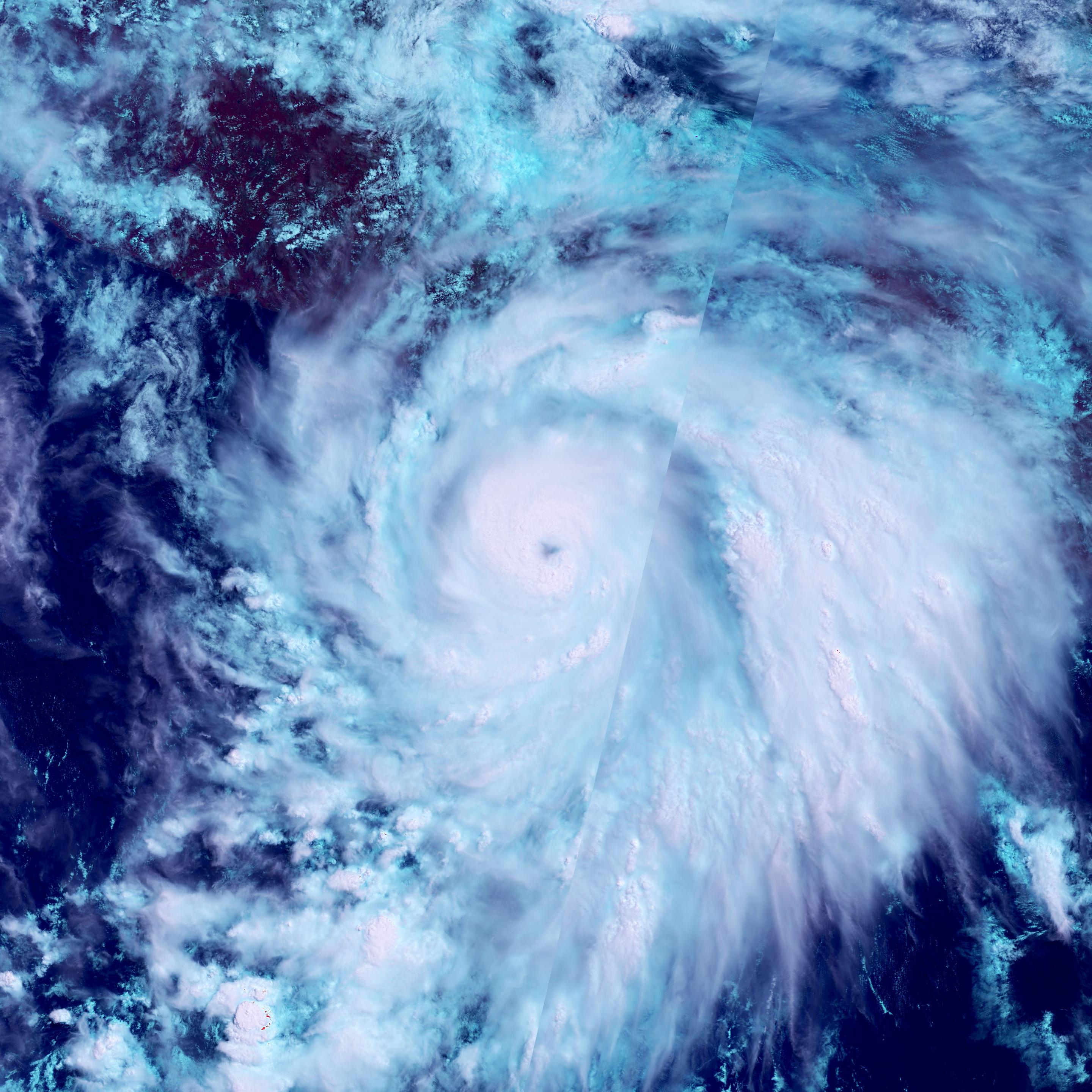
Hurrikan Melissa fegt über die Karibik hinweg
Das unten eingefügte Bild, das am 26. Oktober 2025 von der Copernicus Sentinel-3-Mission aufgenommen wurde, zeigt die „Helligkeitstemperatur“ an der Spitze des Hurrikans Melissa, als er über das Karibische Meer in Richtung Jamaika fegte, wo er voraussichtlich auf Land treffen wird.
Pressemitteilung/Bild ESA. #melissa #Sentinel3
https://www.raumfahrer.net/hurrikan-melissa-fegt-ueber-die-karibik-hinweg/
#Sentinel3


🔥Un jour sans nuages le 22 août sur l'Espagne et le Portugal et cette photo prise par le satellite #Sentinel3 révèle les cicatrices des feux sur les 2 pays (les taches marron).
via @or_bit_eye
🛰️🔥 Terrible image du #feu dans l' #Aude par le satellite #Sentinel3 hier.
Bon courage aux pompiers et aux secours
Via @or_bit_eye

Huge #wildfire (being reported as biggest in France since 1949) in #Aude region, south France seen by #Sentinel3 fire heat signature in red yesterday morning 6 August. Over 2000 firefighters tackling it. #wildfires
🛰️📷🌍 La #France sans nuages le 11 juillet par #Sentinel3.
(via @or_bit_eye)
☀️ Bonne soirée à tous avec cette photo de l'Europe prise par le satellite #Sentinel3 le 1er juillet.
L’absence généralisée de couverture nuageuse indique la présence d’un puissant système de haute pression, un modèle météorologique souvent associé à une chaleur prolongée
RT from Copernicus EU (@CopernicusEU)
Since late June 2025, much of Europe has been affected by an intense heatwave. 🌡️
This #VideoOfTheDay, based on #CopernicusEU #Sentinel3 land surface temperature data, shows values exceeding 50 °C (in deep red). 🔴🟡🟢🔵
🔗More: https://www.copernicus.eu/en/media/image-day-gallery/evolution-heatwave-across-europe
🌡️ Il fait chaud sur l'Europe. Et les données des satellites #Copernicus le confirment. Voici les températures de surface des terres et des mers relevées le 29 juin par le radiomètre du satellite #Sentinel3
📷 Données Copernicus Sentinel modifiées (2025), traitées par l'ESA

The #Sentinel3 team also just mentioned offhand that Sentenel3-NG will support twilight and night observations!
Major #Hurricane #Erick off the coast of Mexico seen early on 18 June by #Sentinel3 , the storm is currently making landfall near Corralero, Oaxaca #HurricaneErick
🤒 Record de température pour le mois de mai en Islande : à l'aéroport d'Egilsstaðir, 26,3 °C a été relevé et 19 °C à la capitale Reykjavík.
Le satellite #Sentinel3 du programme européen #Copernicus a photographié l'Islande le 16 mai, jour de ces températures record.

More stunning acquisitions by #sentinel3 of #Iceland from today. The last couple of days have been exceptionally warm with many stations showing more than 20°C.

This spectacular image of #Iceland was acquired by #Sentinel3 last Saturday. Perfect conditions to hike on top of #Snæfellsjökull glacier with some friends.
The latter part of winter was warm and light in terms of snowfall. The April mean temperature was also one of the hottest on record (4/180).


La Mer d'Aral est l'une des plus grandes preuves du réchauffement climatique et des impacts de l'activité humaine. Autrefois 4e plus grand lac au monde, elle est en train de disparaître.
📷1 en 2006 par le satellite Envisat / 📷2 par #Sentinel3 en mars 2025
Pour zoomer sur l'image de 2025 et pour plus d'explications : https://www.esa.int/ESA_Multimedia/Images/2025/04/Earth_from_Space_The_shrinking_Aral_Sea
🌍☀️ L'Espagne, le Portugal et les Pyrénées sans nuages sur cette image prise le 30 mars par #Sentinel3
Via @PlatformAdam
A nice von Kármán vortex street south of Jan Mayen today 😍🌀🌪️
Image acquired by #Sentinel3
👉🏻 https://en.m.wikipedia.org/wiki/K%C3%A1rm%C3%A1n_vortex_street

R to @CopernicusEU: Snow covering a section of the Atlas Mountains can be seen in this #Sentinel3 image acquired on 19 January 2025.
Read more:
https://www.copernicus.eu/en/media/image-day-gallery/snowfall-atlas-mountains-morocco
---
https://nitter.privacydev.net/CopernicusEU/status/1881984643781832811#m
This #Sentinel3 image acquired on 20 January 2025 shows the Sean cyclone close to the coastline.
On 20 January 2025, the Australian Bureau of Meteorology upgraded Tropical Cyclone Sean to a Category 4 storm off the coast of Western Australia.
https://www.copernicus.eu/en/media/image-day-gallery/tropical-cyclone-sean-australia
---
https://nitter.privacydev.net/CopernicusEU/status/1881621943503512041#m
The recent cold wave which swept across much of Europe has brought abundant snowfall to the Alps, transforming it into a snowy landscape ideal for winter sports enthusiasts.
This #Sentinel3 image from 14 January shows the Alps covered in snow.
https://www.copernicus.eu/en/media/image-day-gallery/snowfall-alps-currently-line-historical-averages
---
https://nitter.privacydev.net/CopernicusEU/status/1879449554602594494#m
On 11 January 2025, Madagascar and the French territory of Mayotte in the Indian Ocean were hit by Tropical Cyclone Dikeledi.
Dikeledi is visible in the Mozambique Channel in this #Sentinel3 image acquired on 13 January 2025.
Find out more:
https://www.copernicus.eu/en/media/image-day-gallery/tropical-cyclone-dikeledi
---
https://nitter.privacydev.net/CopernicusEU/status/1879085938384707986#m
Client Info
Server: https://mastodon.social
Version: 2025.07
Repository: https://github.com/cyevgeniy/lmst