#Skywarn

2025-05-22

was doing my #SkyWarn re-cert last night and shocked at how many people were joining from other NWS offices (Fargo/Grand Forks, several in Michigan/Wisconsin, etc.)

Local WFOs have been absolutely decimated and can't offer training classes they're so understaffed.

#MNWx #NDWx #WIWx #MIWx

Ed W8EMV :city_ann_arbor:w8emv@a2mi.social
2025-05-16

Washtenaw #Skywarn net shutting down at 130a, all warnings in the county have expired.

#miwx

Ed W8EMV :city_ann_arbor:w8emv@a2mi.social
2025-05-16

Report via Washtenaw #skywarn net: sirens going off in Pinckney. #miwx

Ed W8EMV :city_ann_arbor:w8emv@a2mi.social
2025-05-16

weather is happening, a rare midnight callup of the Washtenaw County #skywarn net for 2025-05-16. condition green net, with tornado watch 258 until 0500 for SE Michigan.

tuned in to the #N8DUY repeater

at 0008 the word is that the county gets impacted in about 30 minutes (or 0040 or so). weather coming from the west.

#miwx

2025-05-06

Forty-five people, including your correspondent, showed up for Metro Skywarn spotter training Saturday in Cottage Grove, suburban St. Paul.

That's thought to be a record high number of participants for a session hosted by the Southeast Metro Amateur Radio Club.

"SKYWARN spotters support their local community and government by providing the NWS and their local emergency managers with timely and accurate severe weather reports. These reports, when integrated with modern NWS technology, are used to inform communities of severe weather conditions that could threaten life and/or property."

metroskywarn.org/

We love watching the weather around here. And there's plenty of it!

#HamRadio #Skywarn #SevereWeather
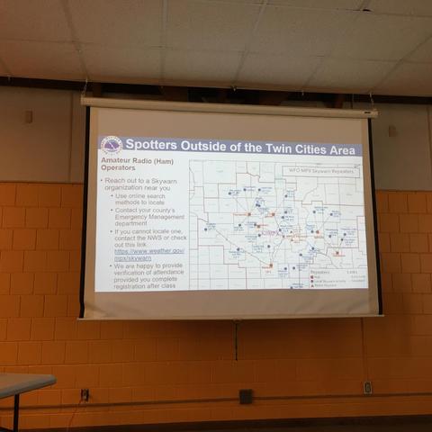
After three hours of instruction on how to recognize key features of severe weather, ham radio operators learned how to use the spotting network to deliver localized storm reports. Anything from funnel clouds and tornados to trees and power lines down and various sized hail.

Slide: Spotters Outside of the Twin Cities Area featured a map of nearby counties in east central Minnesota where radio repeaters are located.
Lloyd Colston, KC5FMkc5fm
2025-04-27

Thanks for the birthday wishes from my , . and friends.

I may be live tomorrow between 4 and 11 PM ET covering severe weather in my area, and activating #Skywarn and using #HamRadio! So stop by and say hi if I'm live. Otherwise I'll see you all later!

a person is using a radio that...

Thanks everyone for tuning into my severe weather stream today! Thanks for keeping me company while I was on the #HamRadio and running a #Skywarn net. We raided over to folkrod! Check em out here! www.twitch.tv/folkrod

Folkrod - Twitch

Ed W8EMV :city_ann_arbor:w8emv@a2mi.social
2025-03-30

Washtenaw County is under a "condition green" #skywarn net, checkins welcomed .

You can tune in on 145.15- MHz N8DUY repeater, PL 100. Or via the Internet on Broadcastify at broadcastify.com/listen/feed/1

I have heard @dzombak check in. I'll be monitoring, but not checking in just yet because my HT can hear the N8DUY repeater but can't hit it from the kitchen, and I do need to cook dinner.

#miwx

Ed W8EMV :city_ann_arbor:w8emv@a2mi.social
2025-03-30

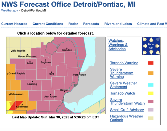
A Severe Thunderstorm Watch has been issued for Washtenaw County.

via the Washtenaw EOC via email

Storms between Fort Wayne and Kalamazoo

THE NATIONAL WEATHER SERVICE HAS ISSUED SEVERE THUNDERSTORM WATCH
75 IN EFFECT UNTIL 10 PM EDT THIS EVENING FOR THE FOLLOWING AREAS

IN MICHIGAN THIS WATCH INCLUDES 17 COUNTIES
IN SOUTHEAST MICHIGAN
BAY GENESEE HURON
LAPEER LENAWEE LIVINGSTON
MACOMB MIDLAND MONROE
OAKLAND SAGINAW SANILAC
SHIAWASSEE ST. CLAIR TUSCOLA
WASHTENAW WAYNE

#miwx #skywarn

Weather forecast for SE Michigan. Purple tint on most of SE Michigan means a severe thunderstorm watch. There is a tornado warning in dark red near Coldwater in Branch County.

From NWS Forecast Office Detroit/Pontiac MI
Ed W8EMV :city_ann_arbor:w8emv@a2mi.social
2025-03-30

@dzombak

I am listening to 145.15- PL 100, the N8DUY repeater which is the local #Skywarn repeater.

That repeater also is on Broadcastify at broadcastify.com/listen/feed/1 so if you tune that you can spot yourself as well, there's enough of a delay in the stream (it says 60 sec) that you can key up and then listen for yourself a minute later.

Ed W8EMV :city_ann_arbor:w8emv@a2mi.social
2025-03-30

Ann Arbor, Ypsilanti and vicinity:

Enhanced Risk of severe thunderstorms between 4:00 PM and 11:00 PM with wind gusts to 70 MPH or greater, large diameter hail, tornadoes, and heavy rainfall possible. Skywarn Spotter activation will likely be required.

via email from washtenaw eoc
for Sunday 2025-03-30

#miwx #skywarn

Meteorologist Austen OnekWDEFAustenOnek
2025-03-27

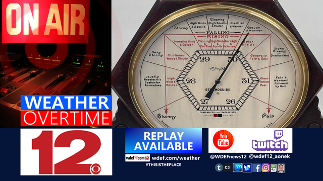
Warm and dry for the remainder of the week. Then, late on Sunday, our next chance of severe weather reaches the area. Also, severe weather training available for the viewing area. More in tonight's @WDEFNews12 .

youtu.be/0Tb0Pu87Alc

Warm and dry for the remainder of the week. Then, late on Sunday, our next chance of severe weather reaches the area. Also, severe weather #Skywarn training available for the viewing area. More in tonight's @WDEFNews12 #weatherblog #WeatherOvertime. 

https://youtu.be/0Tb0Pu87Alc
Lloyd Colston, KC5FMkc5fm@pixelfed.social
2025-03-26
Information you need regarding the Weather Enterprise ... https://www.youtube.com/live/BneDfiNu3Zc?si=BJ32_Mu-7Rrvz0X0 #Skywarn #WRN
Lloyd Colston, KC5FMkc5fm
2025-03-26

Information you need regarding the Weather Enterprise ... youtube.com/live/BneDfiNu3Zc?s

2025-03-20

Severe weather has started rolling in, and the local #HamRadio #SkyWarn net is active. Makes me wonder just how much longer both will exist. I wager at least one will be killed by Summer.

Meteorologist Austen OnekWDEFAustenOnek
2025-03-19

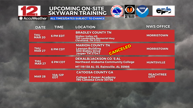
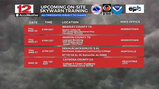
NWS Morristown TN has canceled the training session scheduled for Thu, March 27 in Marion County TN.

NWS Huntsville has rescheduled the meeting for Dekalb & Jackson Counties AL for the same date, 6 PM CDT.

NWS Morristown TN has canceled the #Skywarn #severeweatherspotter training session scheduled for Thu, March 27 in Marion County TN. 

NWS Huntsville has rescheduled the meeting for Dekalb & Jackson Counties AL for the same date, 6 PM CDT.
Victoria (K8VSY) (she/her)k8vsy@mastodon.radio
2025-03-19

today at 9:50 AM EDT (UTC-0400) was the Ohio Statewide Tornado Drill

and the local #Skywarn group #COSWN had their severe weather drill net at the same time, which I got to check in to 🙂

Stay safe everyone!

archive.ph/eLMTA

#OHwx #Ohio #weather #HamRadio #AmateurRadio #hamr #WeatherAwareness #tornado

2025-03-19

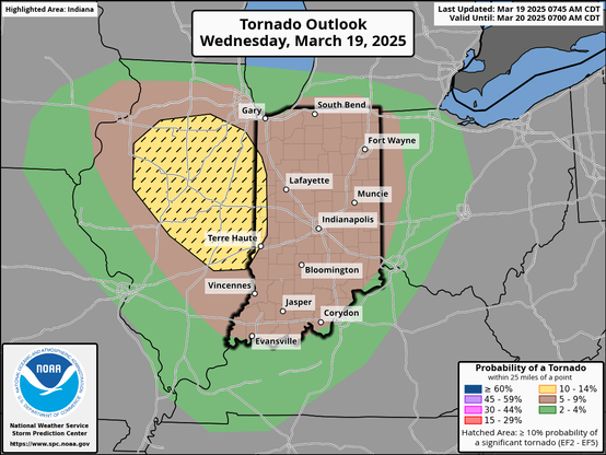
13Z SPC Day 1 outlook indicates elevated #tornado risk throughout Indiana today, with elevated risk of "significant" tornadoes along Illinois line. #INwx #severeweather #Skywarn spc.noaa.gov/products/outlook/

Map of Indiana, shaded to indicate area of various tornado probabilities.
Meteorologist Austen OnekWDEFAustenOnek
2025-03-18

-- Upcoming @nws training sessions in the @wdefnews12 area counties over the next few weeks.

Register for information at the various host NWS Offices at weather.gov

#WhatNOAADoes -- Upcoming @Nws #Skywarn #stormspotter training sessions in the @wdefnews12 area counties over the next few weeks. 

Register for information at the various host NWS Offices at weather.gov

Client Info

Server: https://mastodon.social
Version: 2025.04
Repository: https://github.com/cyevgeniy/lmst