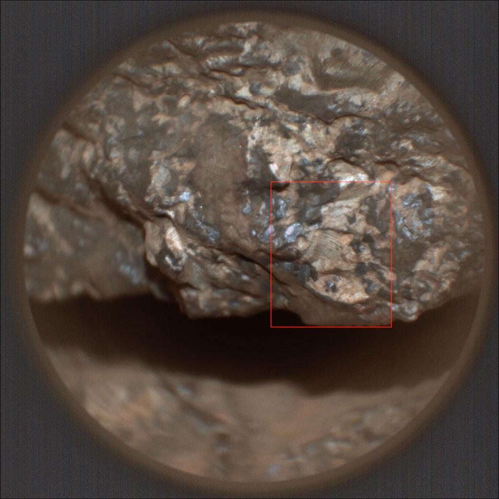
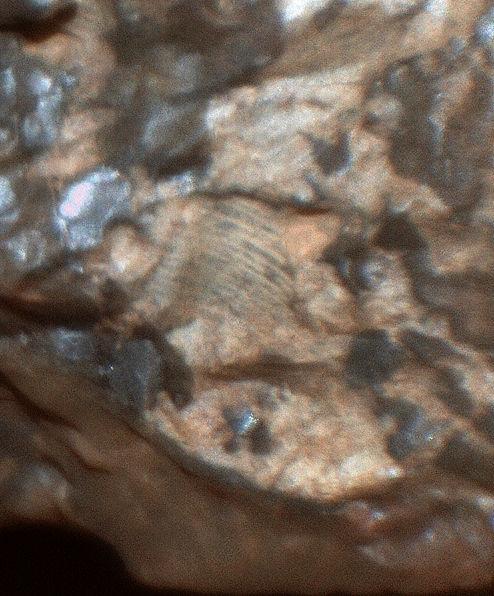
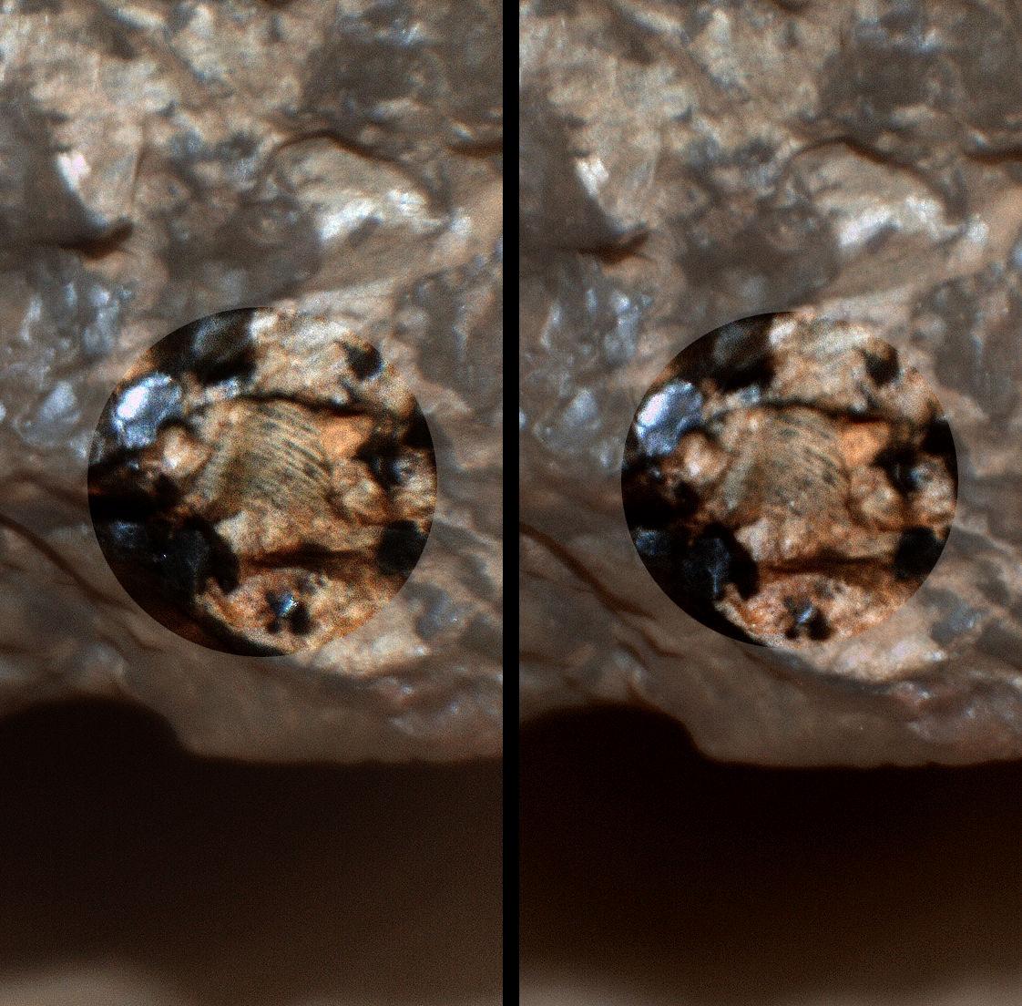
#Solarocks

2025-05-23

The latest abrasion patch on Mars. For scale the diameter of the patch is close to 5cm (2 inches). The image is a single NavCam tile from Perseverance rover and was snapped earlier today, May 23, 2025 or Mars solar day 1513 of its mission on Mars. Credits: NASA/JPL-Caltech

#Perseverance #MarsRover #M2020 #NASA #science #Space #Exploration #Solarocks #Mars

Simeon Schmaußstim3on@fosstodon.org
2025-05-22

The sun was about 13° below the horizon when the Perseverance rover captured this image of the early morning twilight on Mars back in March.
Mars' smaller moon Deimos is shining through the atmospheric haze above the Nili Planum region.

flic.kr/p/2r6neAK

Credit: NASA/JPL-Caltech/Simeon Schmauß

#Perseverance #NASA #Mars #Mars2020 #Solarocks

A grainy picture of Mars taken during astronomical twilight (the sun was 13° below the horizon). It shows a dimly lit reddish landscape with some hills at the horizon. Deimos, Mars' smaller moon shines with a small halo in the pale red-greyish sky above.
2025-05-22

Selected tiled-NavCams after Perseverance rover's drive during sol 1512 (May 22, 2025) to site 74.0. Looks like a site that's ripe for contact science.

Credits: NASA/JPL-Caltech

#Perseverance #MarsRover #M2020 #NASA #science #Space #Exploration #Solarocks #Mars

65dBnoise65dBnoise
2025-05-22

appears to be ready for some close examination of the bedrock at its new location at RMC 74.0000.

As with every change of site number, i.e. when drive numbers are reset to 0000 and the x, y, z data zeroed, localizing the rover is more difficult. Here I've done it by manual triangulation, using NAVCAM_RIGHT images whose center lines are seen on the map.

Used to draw the map, with data from 's , and

2025-05-22

Perseverance Rover on the move again. A drive on sol 1511 (May 21,2025) took the rover SSW and further down-slope. The drive duration was 143 minutes, but that included a pause to capture some images.

#Perseverance #MarsRover #M2020 #NASA #science #Space #Exploration #Solarocks #data #maps #Mars

65dBnoise65dBnoise
2025-05-21

Moving further to the south, after a quick stop at RMC 73.4346 to capture a couple of SUPERCAM images of a blueish rock.

The new path is a guess.

Processed SUPERCAM_RMI
looking SE (144°) from RMC 73.4146
LMST: 12:46:57

Quickly processed, leveled NAVCAM_RIGHT mosaic
looking ENE (72°) from RMC 73.4738
Sol 1511, LMST: 14:37:30

Originals:
mars.nasa.gov/mars2020-raw-ima

Credit: /JPL-Caltech/65dBnoise

65dBnoise65dBnoise
2025-05-20

If that major plateau, Syrtis Major Planitia, or more locally, Nili Fossae, carried water, that would, in general, flow downward towards Isidis Planitia, which is substantially lower in elevation. That in my IANAG / layman understanding could potentially create sediments in the middle-grounds where the Jezero asteroid impacted (image 1).

I think Krokodillen is a lot wider/longer than that, taking into account its stated area of ~30ha (image 2).

65dBnoise65dBnoise
2025-05-19

I wouldn't give a sh*t about a space agency whose PR dept praises the felon "Dear Leader" like they do in North Korea, but I greatly appreciate the openness of its people and their contributions to science and to and , and their exemplary modesty, considering their great personal and collective achievements in space exploration.

So, here is what has been up to, lately:

jpl.nasa.gov/news/nasas-persev

1/

Daniel Pomarèdepomarede
2025-05-19

A Stereo3D view of the boxwork structure captured today by Curiosity

To go 3D: eyes' lines of sight parallel/left image for left eye/right image for right eye.

Sol 4544 - May 19, 2025
📷: NASA/JPL-Caltech

A dual left/right stereoscopic pair of black and white photographies displaying a Martian landscape. This dual image is intended to be used to obtain a Stereo3D rendition of the scene through parallel viewing, and not cross-eyed viewing.
Daniel Pomarèdepomarede
2025-05-19

Cleanly broken by a 900 kg, nuclear-powered Martian robot

May 15, 2025 - Curiosity Sol 4541
Credits: NASA/JPL-Caltech/MSSS/fredk

A rust toned image of a broken Martian rock, revealing a bright white interior.
65dBnoise65dBnoise
2025-05-19

Veni. Vidi. Vici.

is on the move again.

The white stitched path is a guess.

Map made with using data from 's , and .

#

2025-05-18

Cludy Ascraeus Mons - ESA Mars Express

Full size video & more info: flic.kr/p/2r5pcg2
Full size image: flic.kr/p/2r5qrnh
Credit: ESA/DLR/FUBerlin/AndreaLuck CC BY

ESA Mars Express HRSC 2023-08-22
Raw Data: HO799_0000
Real Time: 4 min
Filters used as frames: RE, ND, IR, S1
Colours: RE, GR, BL

Due to the different spectral responses of these filters, I used a script created by @stim3on to deflicker the frames fosstodon.org/@stim3on/1136187

#Space #Astronomy #Mars #Solarocks #Astrodon

Daniel Pomarèdepomarede
2025-05-17

A rock garden visited today by Perseverance, by the edge of the rim of Jezero Crater

▶️ zoomhub.net/gqjb6

May 17, 2025 - Sol 1507
Credits images: NASA/JPL-Caltech/ASU

Martian rocks in the sand.Martian rocks in the sand.Martian rocks in the sand.An ochre toned mosaic of 50 images capturing a Martian landscape
65dBnoise65dBnoise
2025-05-17

Against the wind

Processed MCZ_RIGHT, FL: 110mm
looking from RMC 73.1522
Sol 1507, LMST: 11:07:13

Original: mars.nasa.gov/mars2020-raw-ima

Credit: /JPL-Caltech/ASU/65dBnoise

65dBnoise65dBnoise
2025-05-17

Against the tide

Processed, cropped MCZ_RIGHT, FL: 110mm
looking NNE (17°) from RMC 73.1522
Sol 1507, LMST: 11:08:51

Original: mars.nasa.gov/mars2020-raw-ima

Credit: /JPL-Caltech/ASU/65dBnoise

65dBnoise65dBnoise
2025-05-17

Saturdays on Mars

Processed SUPERCAM_RMI
looking NNE (13°) from RMC 73.1522
Sol 1507, LMST: 12:57:55

Original: mars.nasa.gov/mars2020-raw-ima

Credit: /JPL-Caltech/LANL/CNES/IRAP/65dBnoise

65dBnoise65dBnoise
2025-05-15

Closeup detail of the rock next to the abrasion.

Processed, rotated, cropped SHERLOC_WATSON
looking down (-74°) from RMC 73.1522
Sol 1505, LMST: 14:22:35

Original: mars.nasa.gov/mars2020-raw-ima

Credit: /JPL-Caltech/65dBnoise

65dBnoise65dBnoise
2025-05-15

Martian topoi to the north

(pronounced /'topee/)

Processed, cropped, leveled NAVCAM RIGHT+LEFT
looking NNE (27°) from RMC 73.1522
Sol 1503, LMST: 17:35:36

Cross-eyed 3D

Original: mars.nasa.gov/mars2020-raw-ima

Credit: /JPL-Caltech/65dBnoise

2025-05-15

Perseverance Views Deimos Before Sunrise: The rover captured this view of Deimos, the smaller of Mars' two moons, shining in the sky at 4:27 a.m. local time on March 1, 2025, (Sol 1433), in the dark before dawn, the rover's left navigation camera used its maximum long-exposure time of 3.28 seconds for each of 16 individual shots. In total, the image represents an exposure time of about 52 seconds. Regulus and Algieba are also seen.

#Perseverance #rover #NASA #Space #Solarocks #Mars #Deimos

2025-05-15

Curiosity Rover's current workspace, imaged on mission sol 4539 (May 14, 2025) after a drive to the west of 22.4 meters (~74 ft). The workspace mosaic was assembled from 15 overlapping Bayer reconstructed Left MastCam sub-frame images. Also attached is the detailed drive data and a screen capture of the post-drive traverse map (with scale). Image Credits: NASA/JPL-Caltech/MSSS/fredk.

#CuriosityRover #MSL #MarsRover #NASA #Science #Space #Exploration #Solarocks #Mars #data #map

Client Info

Server: https://mastodon.social
Version: 2025.04
Repository: https://github.com/cyevgeniy/lmst