
#SPC issues Day 1 Enhanced Convective Risk at Mar 15, 5:52z for IND https://www.spc.noaa.gov/products/outlook/archive/2026/day1otlk_20260315_1200.html
#SPC

Severe thunderstorms are not anticipated today. #WeatherAwareDay #weather #wx #SPC #SevereWeather #categorical #tornado #wind #hail #TheOutPost Add'l info in alt text


Severe thunderstorms are not anticipated today.
#WeatherAwareDay #weather #wx #SPC #SevereWeather #categorical #tornado #wind #hail
Add'l info in alt text


Severe thunderstorms are not anticipated today.
#WeatherAwareDay #weather #wx #SPC #SevereWeather #categorical #tornado #wind #hail
Tracking a Winter Storm; Unusual Early-Season Heat Wave in the Southwest
A major winter storm will organize across the Northern Plains today and then rapidly strengthen as it moves into the Great Lakes on Sunday. Heavy snow and blowing snow are likely to persist over the Great Lakes into Monday night. Dry and gusty winds will produce a critical fire risk across the central/southern Plains. An early heatwave will begin to intensify over the western U.S. into next week


Organized severe thunderstorms are not expected. #WeatherAwareDay #weather #wx #SPC #SevereWeather #categorical #tornado #wind #hail #TheOutPost Add'l info in alt text

Organized severe thunderstorms are not expected.
#WeatherAwareDay #weather #wx #SPC #SevereWeather #categorical #tornado #wind #hail
Tracking Late Season Winter Storms; Unusual Early-Season Heat Wave in the Southwest
Heavy snow and high winds continue in the Great Lakes and Northeast. A moderate atmospheric river will continue to bring heavy precipitation to the Pacific Northwest and northern Rockies. A major winter storm will develop across the northern High Plains tonight into Saturday and rapidly strengthen as it moves into the Great Lakes on Sunday. Above-average temperatures expected in the Southwest.

Organized severe thunderstorms are not expected.
#WeatherAwareDay #weather #wx #SPC #SevereWeather #categorical #tornado #wind #hail
Add'l info in alt text


⚠️ Details in ALT Text ⚠️ Pay attention to local meteorologists and reliable weather apps if you live in a colored area on the maps. Stay updated on the weather in your area and be prepared with a plan for severe weather. #weather #wx #SPC #WeatherAware #SevereWeather #TheOutPost

Isolated strong to severe thunderstorms may produce damaging winds across parts of the Southeast this morning into the early afternoon. A tornado can not be ruled out early with this activity. Strong wind gusts are possible across the northern Plains this afternoon as well.
#WeatherAwareDay #weather #wx #SPC #SevereWeather #categorical #tornado #wind #hail
Add'l info in alt text

Isolated strong to severe thunderstorms may produce damaging winds across parts of the Southeast this morning into the early afternoon. A tornado can not be ruled out early with this activity. Strong wind gusts are possible across the northern Plains this afternoon as well.
#WeatherAwareDay #weather #wx #SPC #SevereWeather #categorical #tornado #wind #hail
Widespread High Wind Event; Heavy Snow Expected from the Northern Plains to Northeast
Widespread high winds will continue to impact the interior Northwest, northern Plains, and Upper Midwest. Gusty winds and low relative humidity will bring critical fire weather to the central and southern Plains and south coastal Texas today. A storm tracking across the northern Plains, Great Lakes and into the Northeast U.S. will bring heavy snow and gusty winds into Saturday.

#SPC issues Day 1 Slight Convective Risk at Mar 11, 19:58z for IND https://www.spc.noaa.gov/products/outlook/archive/2026/day1otlk_20260311_2000.html

#SPC issues Day 1 Slight Convective Risk at Mar 11, 16:31z for IND https://www.spc.noaa.gov/products/outlook/archive/2026/day1otlk_20260311_1630.html

Isolated to scattered severe thunderstorms are expected today from the ArkLaTex and Lower Mississippi Valley northeastward through the Ohio Valley and Mid-Atlantic. #WeatherAwareDay #weather #wx #SPC #SevereWeather #categorical #tornado #wind #hail #TheOutPost Important info in alt text

Isolated to scattered severe thunderstorms are expected today from the ArkLaTex and Lower Mississippi Valley northeastward through the Ohio Valley and Mid-Atlantic.
#WeatherAwareDay #weather #wx #SPC #SevereWeather #categorical #tornado #wind #hail
Severe Thunderstorms and Heavy Rainfall from the Lower Mississippi Valley to the Mid-Atlantic; Active Pattern Continues in Hawaii
Scattered severe thunderstorms are expected today from the ArkLaTex and Lower Mississippi Valley through the Ohio Valley and Mid-Atlantic. Thunderstorms may produce heavy to excessive rain that could pose a flooding threat today from east Texas into New York. A powerful kona storm will continue to impact Hawaii through Saturday, bringing heavy rainfall, strong winds, and severe thunderstorms.

Isolated to scattered severe thunderstorms are expected today from the ArkLaTex and Lower Mississippi Valley northeastward through the Ohio Valley and Mid-Atlantic.
#WeatherAwareDay #weather #wx #SPC #SevereWeather #categorical #tornado #wind #hail

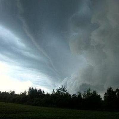
#SPC issues MCD 212 concerning TORNADO WATCH 41 [Most Prob: Tornado: 85-115 MPH, Hail: UP TO 1.25 IN, Gust: 55-70 MPH]: PARTS OF CENTRAL/SOUTHERN IN...OH...NORTHERN KY https://www.spc.noaa.gov/products/md/2026/md0212.html
#SPC issues Day 1 Slight Convective Risk at Mar 11, 12:41z for IND https://www.spc.noaa.gov/products/outlook/archive/2026/day1otlk_20260311_1300.html

#SPC issues MCD 210 concerning SEVERE POTENTIAL...WATCH POSSIBLE [watch prob: 40%] [Most Prob: Tornado: 85-115 MPH, Hail: UP TO 1.25 IN, Gust: 55-70 MPH]: PARTS OF CENTRAL/SOUTHERN IL...CENTRAL IN...WESTERN OH https://www.spc.noaa.gov/products/md/2026/md0210.html
Client Info
Server: https://mastodon.social
Version: 2025.07
Repository: https://github.com/cyevgeniy/lmst