@jccpalmer@mstdn.io I've lived in DC for 13 years now, and walk those gardens, Smithsonian, Wharf, Mall etc several times a week and it never gets old.
Dave Smith
Many hats : Geospatial / Remote Sensing / Data Science - Opinions strictly my own - (formerly) @DruidSmith on Twitter
@the_dp That sounds awesome! And I am also one who cannot resist the Swedish goodies shop at the Ikea checkout
Dave Smith boosted:
A fascinating view of Martian moon Phobos crossing the face of the Sun captured from the surface of Mars by NASA’s Perseverance rover on April 2, 2022.
Credits: NASA/JPL-Caltech/ASU/MSSS/SSI
Further reading: https://www.nasa.gov/feature/jpl/nasa-s-perseverance-rover-captures-video-of-solar-eclipse-on-mars
This 3D mosaic of Mars is pretty cool! https://murray-lab.caltech.edu/CTX/V01/SceneView/intro_c.html
Canada Climate Atlas https://canadiangis.com/the-climate-atlas.php
Nice app for comparing coordinates in different EPSG codes:
@Buxton_Vienna Enjoy your trip! I've lived in DC for 15 years and still enjoy the museums, parks and attractions!
@jgomezdans I'd hope they do - any thoughts from @jeremybowers ?
Dave Smith boosted:
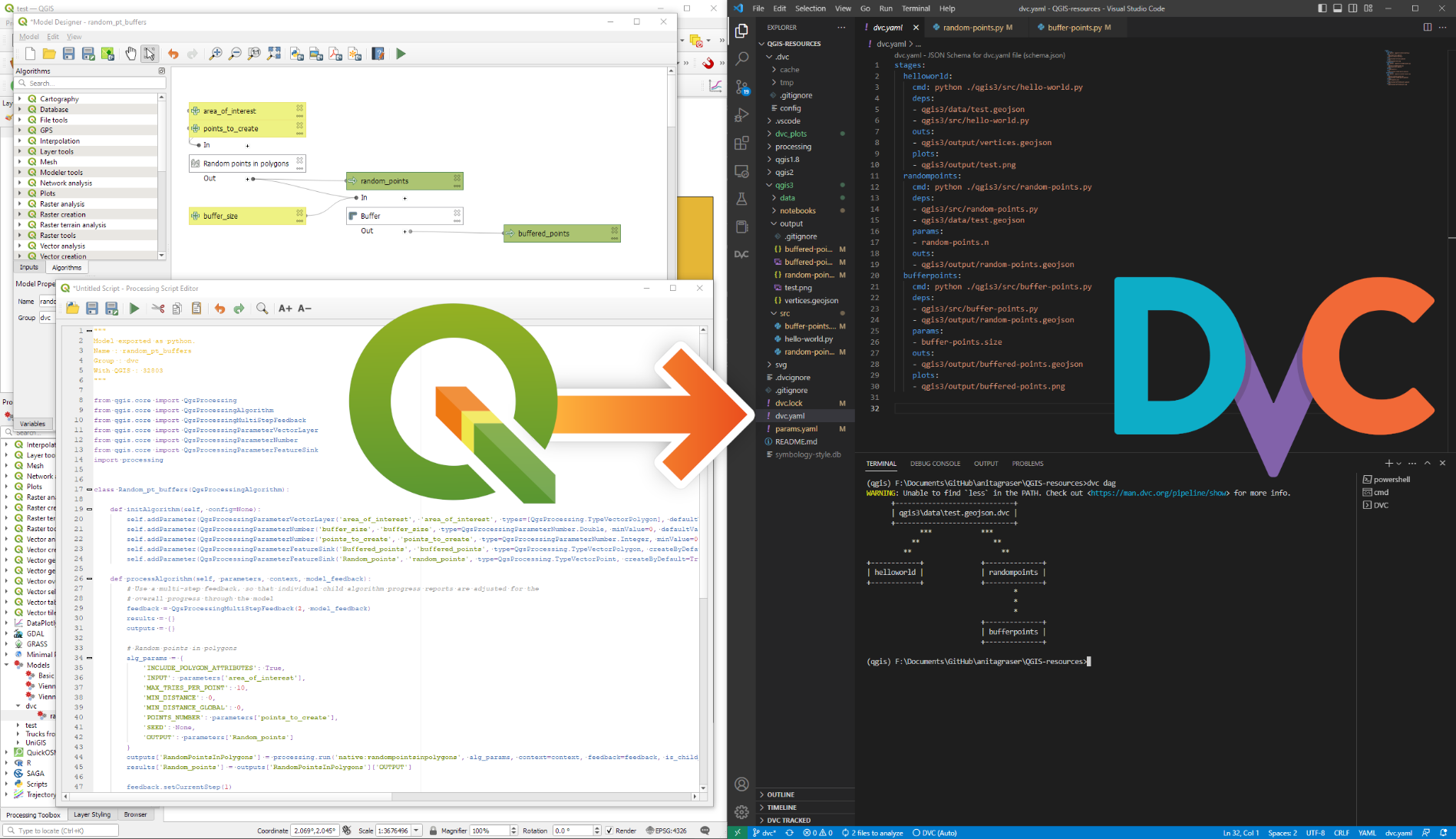
Next level :python: :qgis: #DataScience proof of concept:
Turned a simple QGIS Processing model into a #DVC data-versioned #geoprocessing workflow
"Why is this great?" you may ask ❓
DVC tracks data, parameters, and code. If anything changes, we simply rerun the process and DVC will figure out which stages need to be recomputed and which can be skipped by re-using cached results.
This can lead to huge time savings compared to re-running the whole model 👩💻🥳
@spara That would truly be something...
Handy keyboard shortcuts for #jupyter https://www.dataschool.io/jupyter-notebook-keyboard-shortcuts/
Florence Nightingale and her innovative #dataviz
https://www.bbc.co.uk/programmes/p0f3th3w
Washington post is replacing Mapbox with open source:
https://www.kschaul.com/post/2023/02/16/how-the-post-is-replacing-mapbox-with-open-source-solutions/
Dave Smith boosted:
We live in an age where (a) we can know in advance that we're going to be hit by a 1m-diameter meteor, (b) know where and when the thing is going to land, and then (c) see video of it almost instantly thanks to some random person's pocket supercomputer. Don't tell *me* we're not living in the future. https://www.walesonline.co.uk/news/uk-news/live-newly-discovered-asteroid-set-26222381
@Amonticue I feel that
Dave Smith boosted:
The toll of the disastrous Türkiye & Syria #earthquake has reached ~33,000 casualties
According to @CopernicusEMS , more than 4,000 🏘️have been damaged
⬇️Land deformation interferogram generated using #Sentinel1 🇪🇺🛰️ radar data from 28 January & 9 February
🐦🔗: https://n.respublicae.eu/defis_eu/status/1625102691008405504
Dave Smith boosted:
With MetroHero retiring, WMATA teases tracking website updates of its own: https://ggwash.org/view/88509/breakfast-links-metrohero-app-to-shut-down-wmata-promises-similar-tracking-solution https://dcist.com/story/23/02/10/metrohero-app-shutting-down-wmata-metro-bus-train-wait-times/
Dave Smith boosted:
Thick loess southwest of Broken Bow, Nebraska, sculpted by wind erosion and dissected by streams. Previous research shows coarse late Pleistocene loess in this region can be directly entrained by winds below the threshold for aeolian sand mobility. Troughs and narrow ridges are oriented NW-SE, typical of all large-scale deflation features in Central Plains loess. 3D perspectives created with #rayshader
Client Info
Server: https://mastodon.social
Version: 2025.04
Repository: https://github.com/cyevgeniy/lmst