📢Our research on mapping societal material stocks 🏡🚗 is now featured on the #CDSE page as a use case! #sentinel1 #sentinel2 https://dataspace.copernicus.eu/cases/national-scale-mapping-societal-material-stocks-using-copernicus-data
David Frantz
Asst. Prof. for Geoinformatics - Spatial Data Science, Trier University #Landsat #Sentinel2 #FORCE_EO #datascience #openscience
🚨Job Alert
@Trier University! We are hiring an Assist. Professor (w. tenure track!) in #meteorology & #climatology to strengthen our #geoscience dept. Applications are still possible until August 4! Please RT: https://uni-trier.de/fileadmin/organisation/ABT3/Stellen_Professoren/P3_24_W1_Juniorprofessur_FB_VI_Meteorologie_und_Klimatologie_englisch.pdf
David Frantz boosted:
Manufactured capital is a primary determinant of #sustainable development, with both positive and negative impacts on #wellbeing. Just where it is and how it's constituted matter for #Sustainability but are poorly documented. @davidfrantz et al. point the way forward with an elegant study on "Unveiling patterns in human dominated landscapes through mapping the mass of US built structures" in Nature Communications 14(1) https://nature.com/articles/s41467-023-43755-5
Our #openscience provides a new database for improving #SustainableLiving #circulareconomy #biodiversity #globalchange. Download the open dataset: https://zenodo.org/records/8163466. Browse through the main layers: https://ows.geo.hu-berlin.de/webviewer/us-stocks/
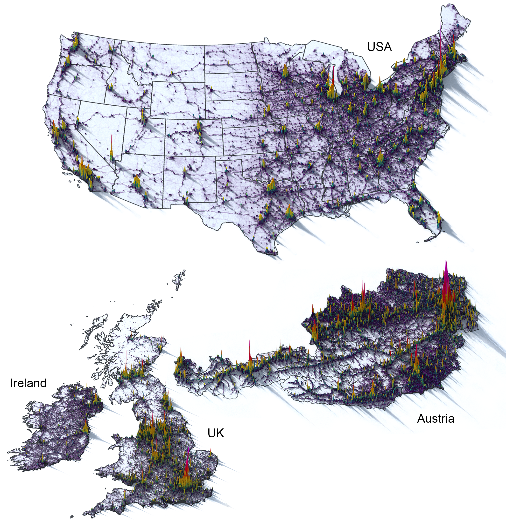
Cities are comparably resource-efficient (~90 t/ cap in the Bronx), while high material intensity is found in rural areas (up to ~40,000 t / cap). Migration reinforces this phenomenon as people leave while built structures remain.
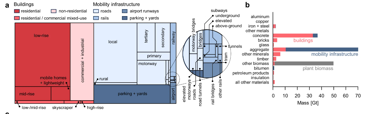
The majority of the mass is not located in dense urban centers but distributed in ubiquitous single-family houses, local roads, and parking spaces across the whole country. Only few inhabited locations have more plant biomass than built-up mass.
We integrated a lot of Earth Observation (#Sentinel2, #Sentinel1, #Landsat) and GIS data with information from industrial ecology and technical engineering to map the mass of 8 building types, 9 road/rail types in 14 construction materials at 10 m resolution for the whole CONUS.
📢Paper alert! How heavy is the USA 🇺🇸🏋️? In a nutshell: the mass of all US buildings, roads/rails, and parking spaces is ca. 130 Gt - or ~400 tonnes per person! Built structures 🏘️ are 2.6 times heavier than all plant biomass 🌳! https://nature.com/articles/s41467-023-43755-5
@naturecomms #openaccess
@Mixed_Pixels can you measure the rotation speed with this approach?
Hi Mastodon. Finally made the move :)
Client Info
Server: https://mastodon.social
Version: 2025.04
Repository: https://github.com/cyevgeniy/lmst