OpenHistoricalMap

Explore the world throughout history – and local history, and prehistory. The #TimeMachine of maps, created by people like you and dedicated to the #PublicDomain. Charter project of @OpenStreetMapUS and companion to @openstreetmap.

Learn more: osm.wiki/OHM

(Mastodon account run by @jeffme @mxn and bridged as bsky.app/profile/ohm.mapstodon )

#OpenHistoricalMap #OpenStreetMap #DigitalHumanities #OpenData #HGIS

OpenHistoricalMapohm@mapstodon.space
2025-06-17

@awinkler We also have a pretty active forum - forum.openhistoricalmap.org/ & Discord channel at OSMWorld Discord - #openhistoricalmap at discord.gg/openstreetmap

One other note - we do not use a database license for our freely-available downloads and user submissions default to CC0, although we have some flexibility around that when importing existing datasets.

#PublicDomain #Crowdsourcing #OSM #DigitalHumanities

OpenHistoricalMapohm@mapstodon.space
2025-06-17

@awinkler - please check out our wiki - wiki.openstreetmap.org/wiki/Op. That explains the very bare bones basics about OHM, but you can use almost any getting started with O*S*M tutorial, because OHM uses the OSM platform. Everything pretty much works the same way. We do have some differences in recommended tags that enable time (start_date & end_date) and we also highly encourage the sourcing of individual elements (as opposed to changesets...). We'd love to have you there!

OpenHistoricalMapohm@mapstodon.space
2025-06-14

And that’s just a couple of the many things we’ve been up to lately. Keep the feedback coming and we’ll see you on the map!

OpenHistoricalMapohm@mapstodon.space
2025-06-14

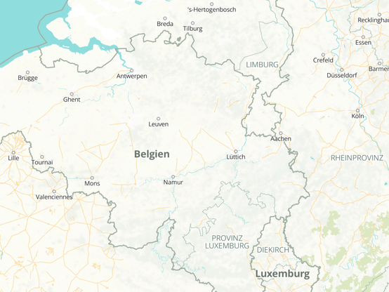
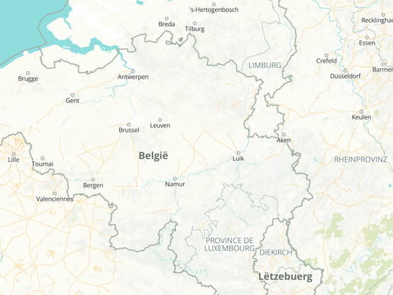
Labels on the map match your preferred language, just like the rest of the site. You can set your preferred language in settings. Now you can understand the map even if you don’t speak a language that was common halfway around the world centuries ago. For mappers, it’s a lot easier to see opportunities to improve our language coverage.

#localization #internationalization #multilingualism

Belgium, Luxembourg, Cologne, and other place labels in French as of 100 years agoBelgium, Luxembourg, Cologne, and other place labels in Dutch as of 100 years agoBelgium, Luxembourg, Cologne, and other place labels in German as of 100 years ago
OpenHistoricalMapohm@mapstodon.space
2025-06-14

Do you already contribute to @openstreetmap? You can start contributing to OpenHistoricalMap too in just a few clicks, without having to juggle yet another password for yet another mapping site. Once you have a taste of OSM #SingleSignOn via #OAuth2, you’ll never look back.

Authorization Required: Authorize OpenHistoricalMap to access your account with the following permissions? Read user preferences, Sign in using OpenStreetMap.
OpenHistoricalMapohm@mapstodon.space
2025-06-14

Just in time for #StateOfTheMapUS next week, we landed some long-awaited features on top of the many other things we quietly released on #OpenHistoricalMap over the past few months. Check out the details on the forum:

forum.openhistoricalmap.org/t/

OpenHistoricalMap boosted:

⏳ Time is running out! Submit your OSM US Public Service Scholarship application to State of the Map US by midnight ET TONIGHT (Sunday, June 8th)!

Details: openstreetmap.us/news/2025/05/

Application: docs.google.com/forms/d/e/1FAI

#SOTMUS #publicservice #OpenStreetMap

OpenHistoricalMap boosted:

Applications are open for the OSM US Public Service Scholarship to State of the Map US in Boston! Thanks to all the individuals who donated so far, we've raised enough to invite 4 scholars to Boston.

Learn more: openstreetmap.us/news/2025/05/

#SOTMUS #publicservice #OpenStreetMap

OpenHistoricalMapohm@mapstodon.space
2025-06-02

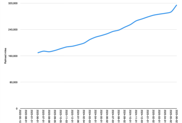
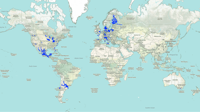
We’ve never seen such a sharp uptick in new railroad coverage like we’ve experienced in May, particularly in present-day Argentina, Finland, and Mexico.

Line graph of railroad miles by month from June 2023 to June 2025 showing a steady rise from about 170,000 to almost 320,000 railroad miles, including a sharp uptick since May 2025.Cumulative world map of everything in OpenHistoricalMap regardless of time period, highlighting railroad tracks modified in May 2025. The rail networks of Mexico, Finland, and Argentina stand out in their entirety, and to a lesser extent in various parts of Europe.
OpenHistoricalMapohm@mapstodon.space
2025-06-02

In the past month, the #OpenHistoricalMap community added 49,939 dated elements, 5,965 buildings, and 293,247¼ railroad miles. The average age of a dated element fell by 14 months, and the average year shifted over 6 months later. All this with the help of 31 new contributors – welcome!

wiki.openstreetmap.org/wiki/Op

OpenHistoricalMap boosted:
CharliePlettCharliePlett
2025-05-31

@ohm No!!! I always got annoyed mapping OSM because I couldn't save the history of places. Now I have such a place.

OpenHistoricalMap boosted:
OpenHistoricalMapohm@mapstodon.space
2025-05-31

@CharliePlett option to import green squares from #OpenHistoricalMap to OpenStreetMap? 😼 #mashup

OpenHistoricalMapohm@mapstodon.space
2025-05-31

@CharliePlett option to import green squares from #OpenHistoricalMap to OpenStreetMap? 😼 #mashup

OpenHistoricalMap boosted:
OpenHistoricalMapohm@mapstodon.space
2025-05-27

@ShionAmasato Love this example of finding information on old buildings and using OpenHistoricalMap as a place to store that data!

#DigitalHumanities #HGIS

OpenHistoricalMapohm@mapstodon.space
2025-05-27

@ShionAmasato Love this example of finding information on old buildings and using OpenHistoricalMap as a place to store that data!

#DigitalHumanities #HGIS

OpenHistoricalMap boosted:
2025-05-25

Two new themes have dropped:

For all the #train enthusiasts out there: mapcomplete.org/historic_rolli shows a map of historical locomotives and other rolling stock that are permanently placed somewhere - e.g. monuments, in a museum or just abandoned.

mapcomplete.org/historic_aircr is a similar map showing #aircraft , interlinking with #wikidata for the models.

Beware: they are dangerous: they are quite addictive to get everything right...

OpenHistoricalMap boosted:
2025-05-20

“Historians use data science to mine the past,” in PNAS, provides an overview of how historians are using computational methods to analyze digitized sources.

These methods become more essential as historians start working with more recent born digital records at scale. pnas.org/doi/10.1073/pnas.2508

OpenHistoricalMap boosted:
2025-05-14

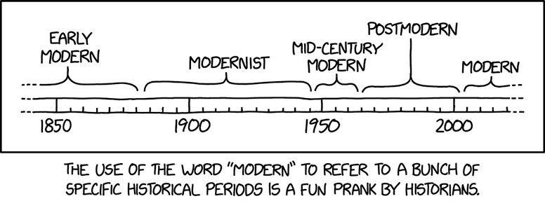
#3089 - Modern

The image is a comic strip with a horizontal timeline ranging from 1850 to 2000. Various historical periods are labeled above the timeline with braces indicating the span of each period:

- From around 1850 to the late 19th century: “Early modern”
- From the late 19th century to the mid-20th century: “Modernist”
- Around the middle of the 20th century: “Mid-century modern”
- Just after mid-century to the late 20th century: “Postmodern”
- From the late 20th century onward: “Modern”

Below the timeline, a caption reads: “The use of the word ‘modern’ to refer to a bunch of specific historical periods is a fun prank by historians.”

Hidden text: "Scholars are still debating whether the current period is post-postmodern or neo-contemporary."
OpenHistoricalMapohm@mapstodon.space
2025-05-06

@grimalkina Next month’s #StateOfTheMapUS will have a healthy mix of the human and tech sides, both grassroots and institutional, that would be relevant to those in or adjacent to #GIScience. Our friends at @OpenStreetMapUS offer discounts for academic affiliation, and they just started raising funds to hopefully offer scholarships for affected government employees too. en.osm.town/@OpenStreetMapUS/1

OpenHistoricalMap boosted:

🍎 Happy Teacher Appreciation Day! We have a special offer for educators interested in attending State of the Map US: Use code "TEACHERS-ROCK" on the Academic & Nonprofit Admission ticket option for three days of SotM US for $150!
🔗 bit.ly/sotmus2025tix

This code is only valid on May 6, 2025, for the Academic and Nonprofit ticket. A .edu email address is required during registration to take advantage of the discount.

#teacherappreciation #StateoftheMapUS #OpenStreetMap #geography

Client Info

Server: https://mastodon.social
Version: 2025.04
Repository: https://github.com/cyevgeniy/lmst