#MiningImpact

2025-11-10

šŸŒ¬ļø Dust for Everybody, Free of Charge…!

This is the English translation of my earlier article analyzing the recurring dust storms caused by tailings and waste dumps in the Kryvyi Rih Iron Ore Basin.

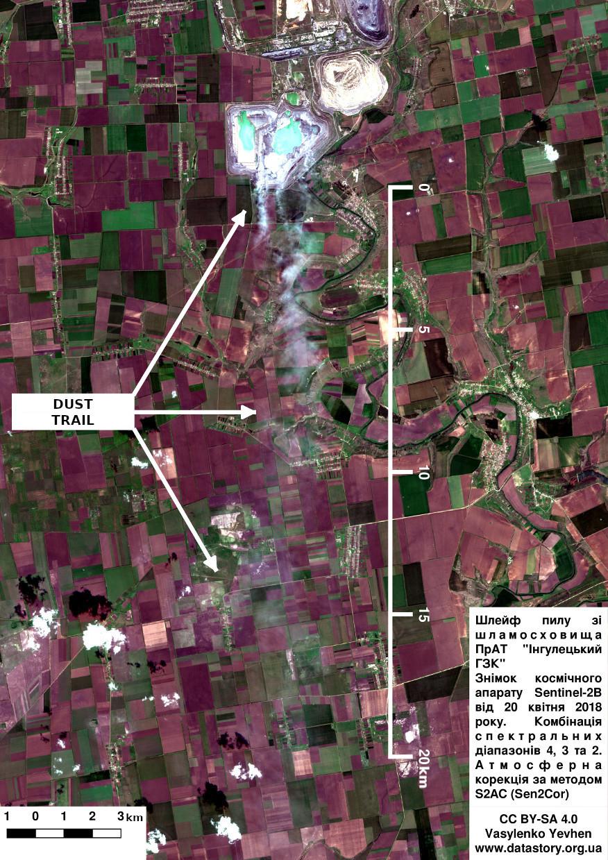
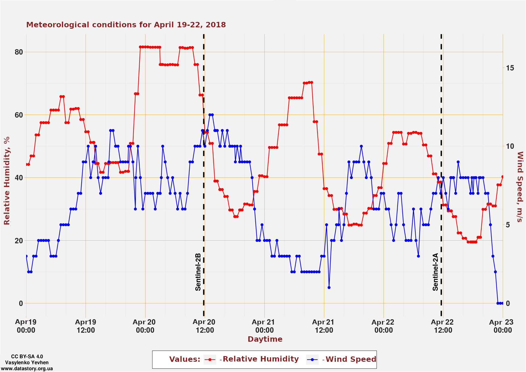
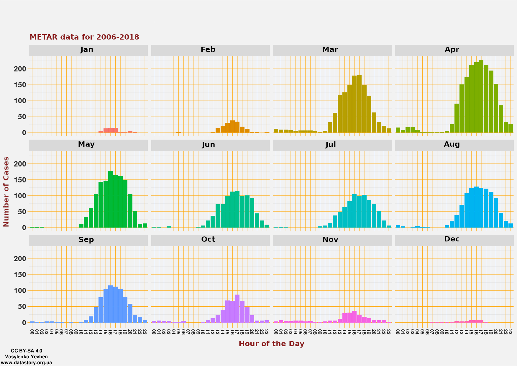
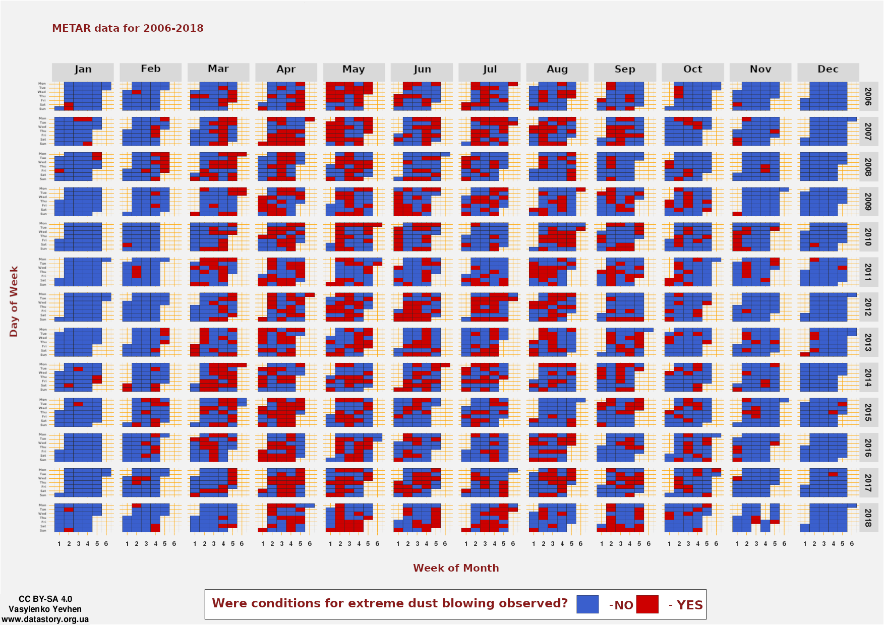
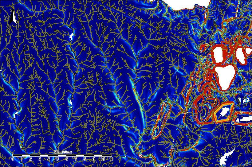
Using large meteorological datasets and satellite observations, I demonstrated that extreme dust emissions coincide with the region’s dry spring winds — a seasonal pattern that persists year after year.

The findings challenged local industrial ā€œdust controlā€ programs, showing that their methods do not reflect real climatic conditions.
The publication sparked a wide public debate, meetings of the municipal working group, and eventually led to updates in enterprise dust-suppression policies.

šŸ“Ž The article is here:
datastory.org.ua/dust-for-ever

#EnvironmentalScience #RemoteSensing #AirPollution #DustEmission #MiningImpact #ClimateData #KryvyiRih #IndependentResearch #OpenScience #Sustainability #RStats #QGIS #METAR #NOAA

Dust trails from the tailings ponds of the ā€œIngulets Mining and Processing Plantā€Meteorological conditions in Kryvyi Rih region on April 19-22, 2018Number of cases of observed wind speed ā€œ7 m/s and moreā€ combined with relative humidity ā€œ60% and lessā€Days when meteorological conditions conducive to extreme dust blowing from tailings ponds were observed
2025-11-10

🌊 Hydrological patterns in the Inhulets River Basin

I’m working on a large-scale study of the technogenic impact on the Inhulets River system (Ukraine).
The workflow combines R + SAGA GIS + QGIS for geomorphometric and hydrological analysis.

Over the past week, I’ve been refining digital elevation models and tracing surface runoff connectivity — not an easy task in a region reshaped by century of mining.

The map below shows one of the calmest and most ā€œwell-behavedā€ areas, far from the mining zone.
As for the drainage network over the mining areas… let’s just say it’s geological chaos down there šŸ˜„

šŸ›°ļø Data: Copernicus DEM (GLO-30)
🧭 Tools: SAGA GIS (Terrain Analysis), R, QGIS

#Hydrology #Geomorphometry #SAGAGIS #QGIS #RStats #DEM #GIScience #EnvironmentalModeling #MiningImpact #Geodata #InhuletsRiver #Ukraine #KryvyiRih #Copernicus #CopernicusDem

Extracted drainage network and real surface area patterns for the western part of the Inhulets Basin. Generated in SAGA GIS using the Terrain Analysis module.
The Times of Central Asiatimesca.com@bsky.brid.gy
2025-03-20

Concerns grow over waste dumps at Kyrgyzstan's Kumtor mine potentially threatening nearby rivers, though the mining company downplays immediate risks timesca.com/kyrgyzstans-... #Kyrgyzstan #KumtorMine #MiningImpact #EnvironmentalConcerns

Kyrgyzstan's Largest Gold Depo...

The Times of Central AsiaTheTimesofCentralAsia@federated.press
2025-03-20

Concerns grow over waste dumps at Kyrgyzstan's Kumtor mine potentially threatening nearby rivers, though the mining company downplays immediate risks timesca.com/kyrgyzstans-larges #Kyrgyzstan #KumtorMine #MiningImpact #EnvironmentalConcerns

Headlines Africaafrica@journa.host
2025-01-16

Southern Africa: Giant Freshwater Aquifer in Southern Africa Is Under Threat From Mining: [The Conversation Africa] A huge underground water resource the size of Austria, the Stampriet Transboundary Aquifer System, stretches for 87,000km² across Namibia, South Africa and Botswana. It supplies 50,000 people in several towns with water pure enough to drink, and is their only source of… newsfeed.facilit8.network/THNs #SouthernAfrica #WaterConservation #AquiferProtection #MiningImpact #FreshwaterResources

The RV Sonne is on a two month expedition to learn more about the impact of #deepseamining. On board are @StratmannTanja@twitter.com and @gollner_sabine@twitter.com and many more researchers from other countries. Together they are measuring #miningimpact of an earlier mining pilot.
Read the first blog by one of the German chief scientists Felix Janssen: oceanblogs.org/SO295-MiningImp

Client Info

Server: https://mastodon.social
Version: 2025.07
Repository: https://github.com/cyevgeniy/lmst