Satellite Photo Captures the Demise of the World’s Largest Iceberg https://petapixel.com/2025/05/21/satellite-photo-captures-the-demise-of-the-worlds-largest-iceberg-a23a/ #satelliteimagery #satellitephoto #southgeorgia #antarctica #satellite #iceberg #Space #News #NASA
#SatellitePhoto
Lunar Satellite Takes Photo of Blue Ghost Spacecraft on the Moon https://petapixel.com/2025/03/13/lunar-satellite-takes-photo-of-blue-ghost-spacecraft-on-the-moon/ #nasalunarreconnaissanceorbiter #lunarreconnaissanceorbiter #fireflyaerospace #satellitephoto #lunarlander #moonlander #blueghost #Space #NASA
Man Finds ‘Huge Scar’ on Google Maps and Discovers Unnoticed Tornado https://petapixel.com/2024/11/26/man-finds-huge-scar-on-google-maps-and-discovers-unnoticed-tornado/ #satelliteimages #satellitephoto #Technology #googlemaps #tornado #News
Adorable Cloud That Regularly Appears in the Same Spot Captured by NASA Satellite https://petapixel.com/2024/10/30/adorable-cloud-that-regularly-appears-in-the-same-spot-captured-by-nasa-satellite-taieri-pet/ #lenticularcloud #satellitephoto #satellite #Features #landsat #Space
Satellite Spots ‘Star Trek’ Starfleet Logo Among Dirty Sea Ice https://petapixel.com/2024/09/26/satellite-spots-star-trek-starfleet-logo-among-dirty-sea-ice/ #satellitephoto #starfleet #Features #startrek #arctic #Space #NASA
Satellite Photo Reveals Grand Canyon-Sized Scar on the Surface of Mars https://petapixel.com/2024/07/08/satellite-photo-reveals-grand-canyon-sized-scar-on-the-surface-of-mars/ #satellitephoto #grandcanyon #marsexpress #Space #mars
Satellite Photos and AI Combine to Reveal Secret Roads Damaging Rainforests https://petapixel.com/2024/03/01/satellite-photos-and-ai-combine-to-reveal-secret-roads-damaging-rainforests/ #amazonrainforest #satelliteimage #satellitephoto #Technology #rainforest #roads #News
Signs of spring: the first #satellitePhoto of the season is now available for #fieldwork preparation in NW #Greenland - which reminds me of #cuckoos #KievitsEi #CherryBlossom + other #Phenology signs.
If you like #SatPics + exploring #SatelliteData in general and you don't know #SentinelHUb's #EOBrowser then you're missing out. Full link to full res image:
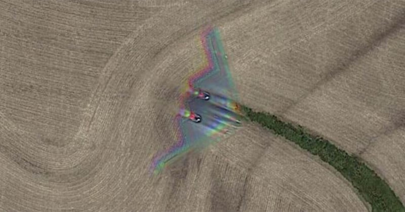
Stealth Bomber Caught Mid-Flight in a Google Maps Photo
A Northrop Grumman B-2 Spirit stealth bomber has been caught flying over farm fields in the Midwest by Google Satellite cameras. It was spotted by a sharp-eyed Google Maps user.
The Discovery of the B-2 Stealth Bomber
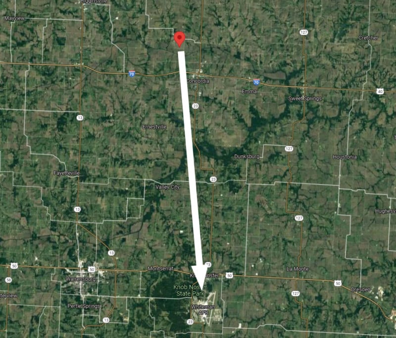
Google has been working to photograph seemingly every inch of the globe for its street and satellite views, and this occasionally results in some unexpected photos. The stealth bomber was discovered by Redditor Hippowned in Missouri about 50 miles east of Kansas City.
The exact coordinates are 39°01’18.5”,-93°35’40.5”, and you can go directly to the spot through this Google Maps link.
A closer crop of the satellite photo showing the B-2 stealth bomber.
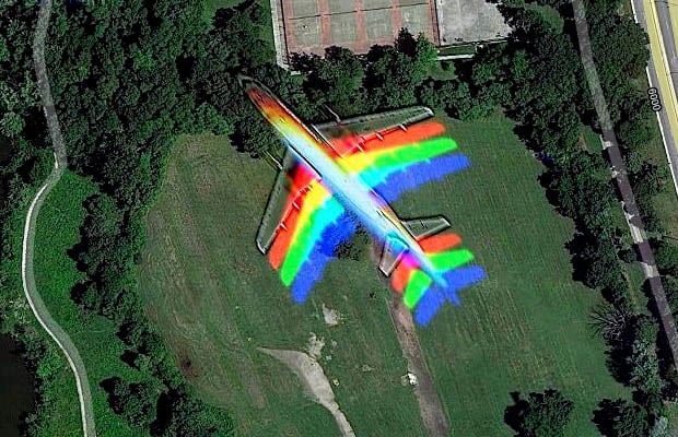
The blurry look of the B-2 in the photo is a result of how the satellite cameras captured photos for the red, green, and blue (RGB) channels separately before combining them into a single full-color image. The same effect was seen back in 2010 when Google's satellites photographed an airliner over Chicago.
Google satellites photographed an airliner flying over Chicago back in 2010.
About the B-2 Spirit Stealth Bomber
The B-2 Spirit is a heavy strategic bomber created during the Cold War that uses stealth technologies for flying through anti-aircraft defenses. Each one is capable of carrying up to 40,000 pounds (~18,000kg) of explosives, including nuclear weapons.
A U.S. Air Force B-2 Spirit flying over the Pacific Ocean in May 2006.
Only 21 of the stealth bombers were built at an average cost of over $2 billion per aircraft, and one of them was destroyed in a crash in 2008, so seeing or photographing one of these bombers may not be easy.
A side view of the B-2 Bomber Spirit of Missouri in 2018.
The ultra-expensive stealth bombers may be good at hiding from enemy detection, but they are not so good at hiding from Google's satellite cameras. On Reddit, where the satellite photo has racked up over 111,000 upvotes, commenters are clearly amused by the discovery.
"More like a photo bomber," writes user RandyGareth.
"Not much of a stealth bomber then huh?" says user Alw4r.
"No one escapes Google," writes p1um5mu991er.
Whiteman AFB: The Home of the B-2 Spirit
For those interested in seeing the B-2 in flight, this location in Missouri is the right place to be. This B-2 was spotted just 20 miles north of Whiteman Air Force Base, the current home of the B-2 Spirit.
All 20 B-2 Spirit stealth bombers currently in service are based at Whiteman AFB.
#culture #news #b2 #b2spirit #caught #google #googlemaps #satellite #satellitephoto #stealthbomber #unexpected
Deepfake Satellite Images Pose Risk to Global Politics and Military: Report
Fake, AI-generated satellite images can pose threat to nations and agencies worldwide, a team of researchers warns. These bogus images could be used to create hoaxes ranging from natural disasters to propping up other fake news, or even be used to mislead international governments into conflicts.
A Deepfake, which is a combination of "deep learning" and "fake," is synthetic media -- both photo and video content generated by artificial intelligence -- often created with the intention of fooling the content consumer. Although the content can be presented as a lighthearted joke in some situations, for example, when a TikTok user impersonated Tom Cruise, deepfakes can also cause issues of varying severity when used maliciously.
The Guardian reports that this type of false visual content is predominantly used for adult content, for example, to map a female celebrity's face onto the adult actor. It's also used to spread false news information or to scam individuals or businesses. In addition to falsifying existing information, deepfakes can create a non-existing person's profile from scratch, which can be further utilized for spying or for other deceitful or illegal means.
In August 2020, PetaPixel reported on the negative impact this type of manipulated media can have both on celebrities and on businesses who are impersonated and pointed out that detecting and keeping up with deepfake technology is a costly and difficult process for any research group that is prepared to tackle this.
However, deepfakes now also present a threat to nations and security agencies in the form of false and misleading satellite imagery, as first reported by The Verge. The bogus satellite images could be used to create hoaxes about natural disasters or to back up false news; it could also "be a national security issue, as geopolitical adversaries use fake satellite imagery to mislead foes."
A recent study, led by University of Washington researchers, examined this concern and "its potentials in transforming the human perception of the geographic world." The study points out that, although detection of deepfakes has had progress to an extent, there are no specific methods for detecting false satellite images in particular.
The team simulated their own deepfakes using Tacoma, Washington as a base map and placed onto it features extracted from Seattle, Washington and Beijing, China. The high rises from Beijing cast shadows in the fake satellite image while the low-rise buildings and greenery were superimposed from the urban landscape found in Seattle.
Study by Bo Zhao, et al. Fake satellite images of a neighborhood in Tacoma with landscape features of other cities. (a) The original CartoDB basemap tile; (b) the corresponding satellite image tile. The fake satellite image in the visual patterns of (c) Seattle and (d) Beijing.
The team explains that anyone unfamiliar with this type of technology would struggle to differentiate between real and fake results, especially because any odd details or colors can be attributed to poor image quality often found in satellite images. Instead, researchers note that to identify fakes, you can examine the images based on color histogram, spatial domains, and frequency domains.
The lead author of the study, Bo Zhao, explains that the study's goal was to raise public awareness of the technology that can be used to misinform and to encourage precautions, with a hope that this study can encourage the development of systems that could point out fake satellite images among real ones.
"As technology continues to evolve, this study aims to encourage more holistic understanding of geographic data and information so that we can demystify the question of absolute reliability of satellite images or other geospatial data," Zhao says to UW News.
Although AI-generated images could create chaos and loss for many security agencies and strategists, the researcher also points out that AI-generated satellite images can be used for positive purposes, too. For example, the technology can help to simulate locations from the past to study climate change, unrestricted growth in urban areas, known as urban sprawl, or how a region may develop in the future.
Image credits: Header photo licensed via Depositphotos.
#news #technology #ai #artificialintelligence #artificialintelligencephotos #deepfake #military #satelliteimages #satellitephoto
Client Info
Server: https://mastodon.social
Version: 2025.04
Repository: https://github.com/cyevgeniy/lmst