#damagingwinds

John :au: :60: :05: :12: :GP:John@fairdinkum.one
2025-05-19

#Evacuations ordered after parts of #NSW received more than 260mm of rain.

#Emergency & watch & act #warnings remain in place for parts of the #NewSouthWales #Hunter & #MidNorthCoast regions, as #intenserainfall, #damagingwinds, & #flashflooding continue. #auspol #weather

Residents in parts of #Bulahdelah have been told to #evacuate their homes, as well as those in #Patterson, #Dungog & #Gloucester. A seek shelter warning is in place for #Taree.

abc.net.au/news/2025-05-20/wea

iWeatherNet 🌪⚡️StormNet
2025-03-13

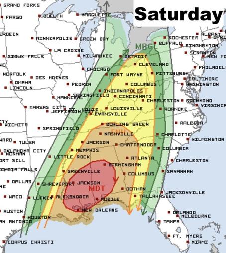
🌪️ We're monitoring a significant severe weather outbreak Friday and Saturday (March 14th & 15th. Saturday's the main concern, with high risks for strong tornadoes (especially in the South), damaging winds, and large hail from the Gulf Coast into the Ohio Valley. Friday will also see severe weather, but with less moisture available. ⚠️ Stay weather aware! iweathernet.com/weathernet-sev

Saturday storm threat for the southern united states. 
A powerful storm system will support widespread damaging winds, strong tornadoes and large hail from Friday through Saturday night. map image of a severe storm system for Friday (Pie Day) 
A powerful storm system will support widespread damaging winds, strong tornadoes and large hail from Friday through Saturday night.  Image shows Arkansas, Texas, Alabama and more plains states.
Stuart Longland (VK4MSL)stuartl@longlandclan.id.au
2025-01-24

The associated warning…

bom.gov.au/products/IDQ21035.s

Severe Thunderstorm Warning - Southeast Queensland
for DAMAGING WINDS, LARGE HAILSTONES and HEAVY RAINFALL

For people in parts of Logan, Redland City, Brisbane City and Moreton Bay Council Areas.

Issued at 7:42 pm Friday, 24 January 2025.

Severe thunderstorms about Logan, tracking north towards Brisbane.

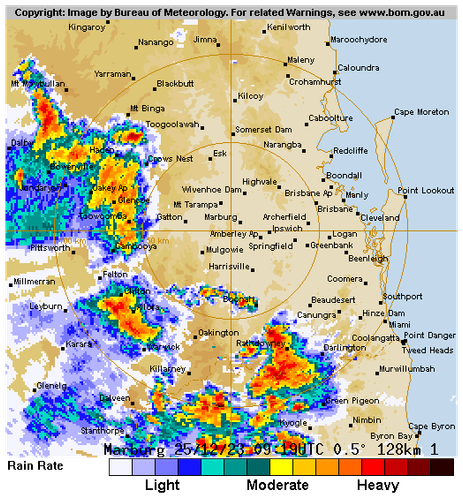
The Bureau of Meteorology warns that, at 7:40 pm, a severe thunderstorm likely to produce damaging winds, large hailstones and heavy rainfall that may lead to flash flooding was detected near Woodridge and Sunnybank Hills. This thunderstorm is moving towards the north. It is forecast to affect Brisbane CBD, Aspley, Boondall and Sandgate by 8:10 pm and Strathpine, Redcliffe, Deception Bay waters and Beachmere by 8:40 pm.

Emergency services advise people to:
* Park your car undercover away from trees.
* Close doors and windows.
* Keep asthma medications close by. Storms and wind can trigger asthma attacks.
* Charge mobile phones and power banks in case the power goes out.
* Put your pets somewhere safe and make sure they can be identified in case they get lost.
* Do not drive now unless you have to because conditions are dangerous.
* Tell friends, family and neighbours in the area.
* Go inside a strong building now. Stay inside until the storm has passed.

The next warning is due to be issued by 8:45 pm.

A more general severe thunderstorm warning is also current for parts of the Southeast Coast district.

Warnings are also available through TV and Radio broadcasts, the Bureau's website at www.bom.gov.au or call 1300 659 210. The Bureau and emergency services would appreciate warnings being broadcast regularly.

#BNEStorm #DamagingWinds #LargeHailstones #HeavyRainfall #LoganQld #RedlandCityQld #BrisbaneQld #Brisbane #BrisbaneCity #MoretonBayQld #WoodridgeQld #SunnybankQld #AspleyQld #BoondallQld #SandgateQld #StrathpineQld #RedcliffeQld #DeceptionBayQld #BeachmereQld

Map of the affected warning area and the cell.

The warning area is roughly circular, centred just north of Brisbane CBD and stretching from Beenleigh to Caboolture.

The storm cell is shown as being elliptical on a 45° angle, upper-left edge just south of Brisbane CBD, lower-right edge just east of Logan Central.  There's an arrow indicating it is headed directly north, with an orange "immediate threat" area path covering a parallel track from here to Caboolture.
Stuart Longland (VK4MSL)stuartl@longlandclan.id.au
2023-12-25

Just refreshed…

Severe Thunderstorm Warning - Southeast Queensland
for #GiantHailstones, #DamagingWinds and #HeavyRainfall

For people in #Ipswich, #ScenicRim and parts of #Logan, #Somerset, #SouthernDowns, #Toowoomba, #LockyerValley, #GoldCoast and #BrisbaneCity Council Areas.

The Bureau of Meteorology warns that, at 7:50 pm, a VERY DANGEROUS THUNDERSTORM likely to produce large, possibly giant hailstones, damaging winds and heavy rainfall that may lead to flash flooding was detected near Laravale and Kooralbyn. This thunderstorm is moving towards the east. It is forecast to affect the #McPhersonRange and the area south of #Canungra by 8:20 pm and #Beaudesert, Little Nerang Dam and Canungra by 8:50 pm.

Other severe thunderstorms likely to produce damaging winds, large hailstones and heavy rainfall that may lead to flash flooding were detected near Laidley, Gatton and the area northeast of Warwick. These thunderstorms are moving towards the east. They are forecast to affect Rosewood, Hatton Vale and Marburg by 8:20 pm and Ipswich, Boonah and the area between Boonah and Beaudesert by 8:50 pm.

Stuart Longland (VK4MSL)stuartl@longlandclan.id.au
2023-12-25

IIIINCOMING!!! #BNEStorm in under a few hours I suspect.

bom.gov.au/products/IDQ21035.s

Severe Thunderstorm Warning - Southeast Queensland
for #DamagingWinds, #LargeHailstones and #HeavyRainfall

For people in parts of #Ipswich, #Somerset, #ScenicRim, #SouthernDowns, #WesternDowns, #Toowoomba and #LockyerValley Council Areas.

The Bureau of Meteorology warns that, at 6:55 pm, severe thunderstorms likely to produce damaging winds, large hailstones and heavy rainfall that may lead to flash flooding were detected near #Dalby, the area northeast of Dalby, #MoogerahDam and #Ellangowan. These thunderstorms are moving towards the east to southeast. They are forecast to affect #Warwick, #Toowoomba and #CrowsNest by 7:25 pm and #Laidley, #Gatton and #Esk by 7:55 pm.

93 km/h wind gust at Dalby at 6:31pm.

96 km/h wind gust at #Oakey at 6:52pm.

Biiig storm cell covering a rectangular area from Dalby to just east of Cambooya, headed east toward Brisbane.

There's also other storm cells harassing the Scenic Rim and Gold Coast.
Stuart Longland (VK4MSL)stuartl@longlandclan.id.au
2023-12-10

Details of Tropical #CycloneJasper at 4:00 pm AEST:

Intensity: category 2, sustained winds near the centre of 100 kilometres per hour with wind gusts to 140 kilometres per hour.
Location: within 55 kilometres of 16.9 degrees South, 153.7 degrees East , 880 kilometres east of #PortDouglas and 850 kilometres east of #Cairns .
Movement: southwest at 14 kilometres per hour .

Tropical Cyclone Jasper, category 2, is moving in a general westwards direction. Jasper is forecast to maintain intensity during Monday and Tuesday. Jasper is forecast to intensify to a category 3 cyclone shortly before making landfall during Wednesday, most likely between #Cooktown and #Cardwell.

Hazards:

#DamagingWinds of 90 km/h are expected to develop along the Queensland coast between #Cooktown and #Ingham, including #Cairns from Tuesday. DAMAGING WINDS of 90 km/hr may extend as far south as #Townsville or as far north as #CapeMelville depending on Jasper's exact movement.

#HeavyRainfall is expected to develop along the coast from late Tuesday.

As the cyclone approaches the coast, #AbnormallyHighTides are possible and large waves are likely along the coast.

Recommended Action:

People between Cape Melville and Townsville, including Cairns and Cooktown, should consider what action they will need to take if the cyclone threat increases.

- Information is available from your local government.

- For cyclone preparedness and safety advice, visit Queensland's Disaster Management Services website (www.disaster.qld.gov.au).

- For emergency assistance call the Queensland State Emergency Service (SES) on 132 500 (for assistance with storm damage, rising flood water, fallen trees on buildings or roof damage).

bom.gov.au/products/IDQ65002.s

Client Info

Server: https://mastodon.social
Version: 2025.04
Repository: https://github.com/cyevgeniy/lmst